
BlockBefore
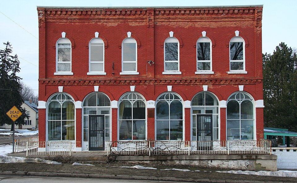
Photograph of Weaver Mercantile Building
Photograph by Jonathunder, CC BY-SA 3.0. Via Wikimedia Commons.

Weaver Mercantile Building

Listed on the National Register of Historic Places in 1978.

From the record

“The Weaver Mercantile Building is a historic building in the unincorporated community of Weaver, Minnesota, United States, built in 1875. It was listed on the National Register of Historic Places in 1978 for having local significance in the themes of architecture and commerce.”

Wikipedia article Weaver Mercantile Building, CC BY-SA 4.0.

One of 26 National Register listings published here for Wabasha County · listed in 1978 · category: Building.

Sources: the Wikipedia article · the case file at the National Archives · the National Register database, National Park Service

The listing

  • What is counted as historic. The nomination lists 1 building as contributing to the listing.
  • Address. U.S. 61 and MN 74, Minneiska, 55910
  • When was it listed? September 1978
  • Category. building
  • Township. Minneiska township
  • Architectural style. Renaissance Revival architecture
  • National Register reference number. 78001567 - the number the National Park Service assigned this property when it was listed, and the key its nomination file is catalogued under at the National Archives.

The ground it stands on

1,828 words

The chapter on Minneiska Township in History of Wabasha County : Together with Biographical Matter, Statistics, Etc. : Gathered from Matter Furnished by Interviews with Old Settlers, County, Township, and Other Records, and Extracts from Files of Papers, Pamphlets, and Such Other Sources As Have Been Available : Also a History of Winona County, published 1884 names Minneiska. This is what it says, exactly as the scans read.

Minneiska is a fractional town, and falls far short of containing the requisite number of sections to constitute a full government township, there being but thirteen complete sections in it, while the eight other parts of sections, which form its eastern boundary, are much curtailed by the course of the river.

Passage source: History of Wabasha County : Together with Biographical Matter, Statistics, Etc. : Gathered from Matter Furnished by Interviews with Old Settlers, County, Township, and Other Records, and Extracts from Files of Papers, Pamphlets, and Such Other Sources As Have Been Available : Also a History of Winona County, published 1884.

Tiie first settlement within the limits C)f what is now known as the town of Minneiska was made as early as 1S51, Michael Agnes coming up from St. Louis in August of that year, and building a shanty on the southeast corner, on the river side. Louis Krutely followed the same summer, settling near Agnes. During the same year Charles R. Reed, of Reed's Landing, purchased a claim some four miles further up the river. These men only built shanties to shelter themselves while cutting wood for the steamboats that plied up and down the river, and broke no ground for cultivation during their first year. Their mainstay for subsistence was the rod and the rifle, and very often they had nothing but fish and fowl, and considered themselves fortunate if they could occasionally trade their game for some flour and other necessaries with the stewards of the steamers. The total sale of their wood during the summer did not buy enough food to supply them during the winter, and they had a hard time to pull through until the following spring. Steamboats were not as plenty on the rivers in those days as now, and the advent of a steamer passing at intervals of weeks was a godsend to these hardy men. Tliej' used to climb a tree on the island opposite to where now is built the pretty village of Minneiska, commanding a view of the river up and down for several miles, to> sight a coming boat, and it was with feelings of anxiety, as their supplies would

Passage source: History of Wabasha County : Together with Biographical Matter, Statistics, Etc. : Gathered from Matter Furnished by Interviews with Old Settlers, County, Township, and Other Records, and Extracts from Files of Papers, Pamphlets, and Such Other Sources As Have Been Available : Also a History of Winona County, published 1884.

Machine-read from a century-old scan, so expect the errors a machine makes: misspelled names, dropped words, stray characters.

Read the whole chapter on Minneiska Township - 1,828 words on its settlement, mills, schools and churches.

Fires near this property

35 since 1992

Regional context, not property-specific evidence. The federal wildfire occurrence database lists 35 fires within 5 miles of Weaver Mercantile Building between 1992 and 2020, burning about 512 acres in total. None started naturally. 9 were recorded as arson. Distance is straight-line from the map coordinates, so a fire counted here may appear on a neighbouring settlement's page as well.

Reported cause Fires
Arson/incendiarism9
Missing data/not specified/undetermined8
Smoking6
Recreation and ceremony5
Equipment and vehicle use3
Debris and open burning3
Railroad operations and maintenance1

The most recent of them, most recent first, with the day each was reported and the service that recorded it.

DateCause SizeReported by Name on the report
30 September 2000Missing data/not specified/undetermined1.0 acresMinnesota Department of Natural Resourcesnot named
2 August 2012Recreation and ceremony15 acresMinnesota Department of Natural Resourcesnot named
5 July 1996Smokingunder an acreMinnesota Department of Natural Resourcesnot named
29 July 2015Missing data/not specified/undeterminedunder an acreMinnesota Department of Natural Resourcesnot named
29 July 1993Missing data/not specified/undetermined5.0 acresMinnesota Department of Natural Resourcesnot named
28 July 2004Missing data/not specified/undetermined5.0 acresMinnesota Department of Natural Resourcesnot named
4 June 1992Recreation and ceremonyunder an acreMinnesota Department of Natural Resourcesnot named
5 May 2014Debris and open burning1.0 acresMinnesota Department of Natural Resourcesnot named

Every fire recorded in Wabasha County

Mines and quarries near this property

9 within 5 miles

Regional context, not property-specific evidence. The federal mineral resources record lists 9 workings within 5 miles of Weaver Mercantile Building: 6 occurrences, 2 past producers, 1 producer. 1 still produces. What was taken out: Sand and Gravel, Construction, Clay, Stone, Crushed/Broken. Distance is straight-line from the map coordinates, so a quarry counted here may appear on a neighbouring settlement's page as well.

Where SiteCommodity StatusRecorded
Dodge County Clay DepositClayOccurrence
Weaver QuarryStone, Crushed/BrokenProducer
Averbeck Gravel DepositSand and Gravel, ConstructionOccurrence
Buffalo City Gravel DepositSand and Gravel, ConstructionOccurrence
Buffalo City Gravel PitSand and Gravel, ConstructionPast Producer
Foegen Road Gravel DepositSand and Gravel, ConstructionOccurrence
J. Martin Gravel DepositSand and Gravel, ConstructionOccurrence
Lizzy Pauls Pond Gravel PitSand and Gravel, ConstructionPast Producer
River Road Gravel DepositSand and Gravel, ConstructionOccurrence

Every working recorded in Wabasha County

Map coverage status

No historic map-sheet match is published for this property yet. That does not mean no map exists. This record needs a coordinate-quality review before it can be joined to a sheet boundary. Browse the county's mapped places while that work is pending.

Sources for this property

National Archives recordThe nomination case file for reference 78001567 in Record Group 79.
Wikipedia articleCommunity-written account of this property, licensed CC BY-SA.
Wabasha CountyAll 26 listed properties in this county.

Provenance

  • Listing record. National Park Service National Register of Historic Places, listed-properties dataset, current to 2026-05-22.
  • Map join. Address geocoded through the United States Census geocoder, then tested against the published boundary of every sheet in the USGS Historical Topographic Map Collection.
  • How this page is made. Listing fields come from federal records; map-sheet coverage is a labelled coordinate-to-boundary calculation, not a source-field claim.
  • Wildfire. Short, Karen C. 2022. Spatial wildfire occurrence data for the United States, 1992-2020 [FPA_FOD_20221014]. 6th Edition. Fort Collins, CO: Forest Service Research Data Archive. https://doi.org/10.2737/RDS-2013-0009.6 Collected with United States Government funding and usable without additional permissions or fees.
  • Mines and quarries. USGS Mineral Resources Data System (MRDS) https://mrdata.usgs.gov/mrds/ A work of the United States government, no copyright under 17 U.S.C. 105.