BlockBefore
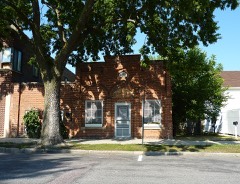
Photograph of Boesch, Hummel, and Maltzahn Block
Photograph by Bobak Ha'Eri, CC BY 3.0. Via Wikimedia Commons.

Boesch, Hummel, and Maltzahn Block

Built in 1890. Listed on the National Register of Historic Places in 1979.

From the record

One of 38 National Register listings published here for Brown County · listed in 1979 · category: Building · built in 1890.

Sources: the case file at the National Archives · the National Register database, National Park Service · the Wikipedia article

The listing

  • What is counted as historic. The nomination lists 1 building as contributing to the listing.
  • Address. 6-12 N. Minnesota St., New Ulm, 56073
  • When was it listed? December 1979
  • Category. building
  • Also known as. Brown County MRA
  • City. New Ulm city
  • When was it built? 1890
  • National Register reference number. 79001201 - the number the National Park Service assigned this property when it was listed, and the key its nomination file is catalogued under at the National Archives.

What happened here

An account from the chapter on New Ulm city. The inset identifies its exact source book and publication year.

From History of Brown County, Minnesota: Its People, Industries and Institutions (Volume 1), published 1916 - New Ulm City

Municipal History

New Ulm was incorporated in March, 1857, and William Pfaender was elected its first president. Later it was incorporated as a borough, with Charles Roos as mayor. A city charter was granted New Ulm on February 24, 1876, with Charles Roos as mayor and Jacob Nix as clerk. Since the place was incorporated into a city the records are all intact, but on account of the Indian depredations during the massacre in August, 1862, the early village records were all destroyed or lost.

Read the rest of this passage

The ground it stands on

3,395 words

The chapter on New Ulm City in History of Brown County, Minnesota: Its People, Industries and Institutions (Volume 1), published 1916 names New Ulm. This is what it says, exactly as the scans read.

New Ulm, the seat of justice of Brown county, on the right bank of the Minnesota river, was named by its founders after an important city and an old fort standing on the shore of the Danube in Wurtemberg - Ulm - which word is a combination of the initials of the old Roman legend, " Ultra limites militares," which, translated into our language signifies 6 i Beyond the military border/ ' as the Romans usually called the territory adjoining their possessions in distant countries. It will be understood by the reader from what has already been noted, this place in Brown county was first settled and has always been almost exclusively a German town, hence it was but natural that the founders named it from Ulm, in Wurtemberg, and added the prefix "New," making it New Ulm.

Passage source: History of Brown County, Minnesota: Its People, Industries and Institutions (Volume 1), published 1916.

The object in laying out New Ulm was stated in a resolution passed by the company or colony that headed the enterprise in the following words: "The object of the German Land Company is to procure a home for every German laborer, popish priests and lawyers excepted, in some healthy and productive district, located on some navigable river." With the passing years, both priest and lawyer have here found a welcome and have been numerous, as well as truly law-abiding citizens of a sprightly city whose history reads not unlike a romance from the early fifties on down for more than a third of a century, which covered the awful baptism of blood during the 1862 massacre, as well as that never-to-be-forgotten summer in 1881, when the city was destroyed by a cyclone of fearful velocity.

Passage source: History of Brown County, Minnesota: Its People, Industries and Institutions (Volume 1), published 1916.

Machine-read from a century-old scan, so expect the errors a machine makes: misspelled names, dropped words, stray characters.

Read the whole chapter on New Ulm City - 3,395 words on its settlement, mills, schools and churches.

Fires near this property

13 since 2001

Regional context, not property-specific evidence. The federal wildfire occurrence database lists 13 fires within 5 miles of Boesch, Hummel, and Maltzahn Block between 2001 and 2015, burning about 17 acres in total. None started naturally. 2 were recorded as arson. Distance is straight-line from the map coordinates, so a fire counted here may appear on a neighbouring settlement's page as well.

Reported cause Fires
Debris and open burning6
Recreation and ceremony2
Arson/incendiarism2
Smoking1
Equipment and vehicle use1
Fireworks1

The most recent of them, most recent first, with the day each was reported and the service that recorded it.

DateCause SizeReported by Name on the report
3 September 2007Debris and open burningunder an acreMinnesota Department of Natural Resourcesnot named
1 July 2010Arson/incendiarism1.1 acresMinnesota Department of Natural Resourcesnot named
31 May 2001Debris and open burningunder an acreMinnesota Department of Natural Resourcesnot named
14 May 2008Recreation and ceremonyunder an acreMinnesota Department of Natural Resourcesnot named
19 April 2007Arson/incendiarismunder an acreMinnesota Department of Natural Resourcesnot named
15 April 2007Debris and open burning2.0 acresMinnesota Department of Natural Resourcesnot named
19 December 2006Recreation and ceremony2.0 acresMinnesota Department of Natural Resourcesnot named

Every fire recorded in Brown County

Mines and quarries near this property

2 within 5 miles

Regional context, not property-specific evidence. The federal mineral resources record lists 2 workings within 5 miles of Boesch, Hummel, and Maltzahn Block: 2 producers. All of them still produce. What was taken out: Stone, Crushed/Broken, Sand and Gravel, Construction. Distance is straight-line from the map coordinates, so a quarry counted here may appear on a neighbouring settlement's page as well.

Where SiteCommodity StatusRecorded
New Ulm Quartzite QuarriesStone, Crushed/BrokenProducer
Reinhart PitSand and Gravel, ConstructionProducer

Every working recorded in Brown County

Storms near this property

57 since 1994

Regional context, not property-specific evidence. The National Weather Service names New Ulm, the town this property stands in, in 57 storm reports between 1994 and 2025: 29 thunderstorm wind, 21 hail, 2 lightning, 2 flash flood. No death or injury is recorded in these reports. Each account below is quoted exactly as the forecast office filed it, from the NOAA Storm Events Database, and each date opens the federal record of that event.

WhenEvent Place namedHarm What the report says
July 1998Thunderstorm WindNew Ulm$7,000,0004,000 trees blown down. 10 businesses lost portions of their roof. Mobile home destroyed. Maintenance hangar at airport destroyed, damaging several airplanes. 400 ft TV tower blown down. Poultry bldg levelled at fairgrounds. Reception hall lost its roof. Large trees blown down at local cemeteries. The statue of Hermann the German damaged. Estimated 5% of crops or about 50,000 acres in county destroyed. Damage estimate for entire county.
May 2000HailNew Ulm$500,000More than 100 vehicles at a dealership sustained damage.
March 2010FloodNew Ulm$160,000Numerous county roads around New Ulm were closed due to flooding. Monetary costs were based on FEMA, State, and Local assistance which includes the following categories; emergency protective measures and road systems and bridges.
May 2022Thunderstorm WindNew Ulm$50,000Several trees and power lines blew down, some landed on homes and damaged their roofs around New Ulm.
July 2002Thunderstorm WindNew Ulm$40,000Numerous trees down, including one on a car. Barn and shed also downed.
June 2010Thunderstorm WindNew Ulm$10,000A street light pole was bent over due to severe straight line winds.
September 2021Thunderstorm WindNew Ulm$1,000A large tree was blown down in the city of New Ulm. The regional airport reported a wind gust of 61 mph as the storms moved through the city.
June 1994HailNew Ulm$500no account filed
July 1994HailNew Ulm$500no account filed
June 2025Thunderstorm WindNew Ulm-Thunderstorm winds estimated at 60 mph snapped several large trees snapped at their base in German Park, downed a dead, 2 foot diameter tree along 5th North Street, and downed several trees near the New Ulm Medical Center.
August 2024Thunderstorm WindNew Ulm-Multiple downed trees blocked roads throughout New Ulm.
June 2024Heavy RainNew Ulm-The storm total was 2.5 inches of rainfall.
August 2023Thunderstorm WindNew Ulm-A report of a tree down in the city of New Ulm was related by dispatch. The New Ulm airport west of town had a measured wind gust of 56 mph.
June 2016Thunderstorm WindNew Ulm-A large tree and several large tree branches were blown down in New Ulm.
June 2016Thunderstorm WindNew Ulm-Numerous trees were blown down in New Ulm.
June 2014Flash FloodNew Ulm-Due to excessive rainfall numerous roads were flooded, especially in New Ulm, and slumping took place in several locations.
July 2011Thunderstorm WindNew Ulm-A few trees were blown down around New Ulm, Minnesota.
June 2010Thunderstorm WindNew Ulm-A 50 knot wind gust was measured at the New Ulm, Airport.
June 2010Thunderstorm WindNew Ulm-A measured wind gust at the New Ulm Airport.
July 2008Thunderstorm WindNew Ulm-Several trees blown down.
August 2007Flash FloodNew Ulm-Widespread street flooding occurred. Several cars stranded around New Ulm. The cooperative observer in New Ulm measured 6.82 inches as of 0630 CST August 19.
July 2006Thunderstorm WindNew Ulm-Tree down over Shag Road along Minnesota River.
June 2005Thunderstorm WindNew Ulm-A tree in a marsh near the Minnesota River was downed onto a power line.
June 2005Thunderstorm WindNew Ulm-Numerous trees were downed onto yards and roads. The most concentrated area of damage was in an east-west path between 12th North and Center streets. One large tree pulled up the sidewalk and a portion of the curb on South Minnesota Street.
June 2005Thunderstorm WindNew Ulm-Trees and power poles were downed.
August 2005Thunderstorm WindNew Ulm-Many tree branches were downed throughout town. A tree fell onto a garage in Payne Street.
August 2005Thunderstorm WindNew Ulm-A 60 MPH wind gust was reported via HAM radio.
April 2004Thunderstorm WindNew Ulm-Several trees were downed. The metal roof of a granary was ripped off and blown 100 feet.
September 2004LightningNew Ulm-A home on Garden Street suffered electrical damage after a lightning strike.
September 2004LightningNew Ulm-A residence on South Jefferson Street suffered damage to a tree, transformer, doorbell, and front door after lightning struck.
August 2000Thunderstorm WindNew Ulm-Several trees toppled.
July 1999Thunderstorm WindNew Ulm-Portion of old one story building collapsed onto car. Large tree limbs down. Winds estimated.
July 1998Thunderstorm WindNew Ulm-Windows blown out at Flandreau State Park Bldg. 300 trees down. Two trees blown onto camper. Estimated windspeed.
June 1997Thunderstorm WindNew Ulm-Trees and large branches down on west side of city. Estimated windspeed. About one and one half inches of rain in one half hour resulted in minor flooding at a mobile home park.
May 1994Thunderstorm WindNew Ulm-Thunderstorm winds blew down several large trees in the city of New Ulm. Hail and strong winds damaged several hundred acres of crops in the Springfield area.
August 2023HailNew Ulm-no account filed
May 2022Thunderstorm WindNew Ulm-no account filed
May 2014HailNew Ulm-no account filed
May 2012HailNew Ulm-no account filed
June 2010Thunderstorm WindNew Ulm-no account filed
June 2008HailNew Ulm-no account filed
May 2007HailNew Ulm-no account filed
June 2007HailNew Ulm-no account filed
June 2005HailNew Ulm-no account filed
July 2003HailNew Ulm-no account filed
May 2003HailNew Ulm-no account filed
May 1998HailNew Ulm-no account filed
July 1997HailNew Ulm-no account filed
July 1997Funnel CloudNew Ulm-no account filed
October 1996HailNew Ulm-no account filed
July 1995Thunderstorm WindNew Ulm-no account filed

Every storm recorded in Brown County

Map coverage status

No historic map-sheet match is published for this property yet. That does not mean no map exists. This record needs a coordinate-quality review before it can be joined to a sheet boundary. Browse the county's mapped places while that work is pending.

Listed places nearby

6 within 8 miles

Other National Register properties close enough to walk or drive between, ordered by distance from this one. Both positions come from the same geocoding pass that matched these properties to their map sheets.

Photograph PropertyDistance Listed
New Ulm Commercial Historic Districtunder 500 feet2005
New Ulm Post Officeunder 500 feet1970
Grand Hotel0.1 miles1990
Melges Bakery0.1 miles1974
Gov. John Lind House0.2 miles1974
New Ulm Armory0.2 miles1979

Sources for this property

National Archives recordThe nomination case file for reference 79001201 in Record Group 79.
Wikipedia articleCommunity-written account of this property, licensed CC BY-SA.
Brown CountyAll 38 listed properties in this county.

Provenance

  • Listing record. National Park Service National Register of Historic Places, listed-properties dataset, current to 2026-05-22.
  • Map join. Address geocoded through the United States Census geocoder, then tested against the published boundary of every sheet in the USGS Historical Topographic Map Collection.
  • How this page is made. Listing fields come from federal records; map-sheet coverage is a labelled coordinate-to-boundary calculation, not a source-field claim.
  • Wildfire. Short, Karen C. 2022. Spatial wildfire occurrence data for the United States, 1992-2020 [FPA_FOD_20221014]. 6th Edition. Fort Collins, CO: Forest Service Research Data Archive. https://doi.org/10.2737/RDS-2013-0009.6 Collected with United States Government funding and usable without additional permissions or fees.
  • Mines and quarries. USGS Mineral Resources Data System (MRDS) https://mrdata.usgs.gov/mrds/ A work of the United States government, no copyright under 17 U.S.C. 105.
  • Storms. NOAA National Centers for Environmental Information, Storm Events Database https://www.ncei.noaa.gov/stormevents/ A work of the United States government, no copyright under 17 U.S.C. 105. Narratives are quoted verbatim from the National Weather Service report and are not edited or summarised.