 Block
From the record
One of 22 National Register listings published here for Wright County · listed in 1979 · category: Building.
Sources: the National Register database, National Park Service
Listed on the National Register of Historic Places in 1979.
One of 22 National Register listings published here for Wright County · listed in 1979 · category: Building.
Sources: the National Register database, National Park Service
The chapter on Albertville City in History of Wright County, Minnesota Volume II, published 1915 names Albertville. This is what it says, exactly as the scans read.
Albertville, formerly called St. Michael Station or St. Michael's Station, is an enterprising business center, and an excellent trading point for a good farming district. The village is ineorporated, connected with the outside world by both telephone and telegraph and has excellent schools. Its business men are up and doing, carry large, well selected stocks and are making a bid for patronage in the way of prices that is felt in all sections. Albertville has about 450 inhabitants and is surrounded with as desirable farm lands as are to be found in this great state. It is located on the Great Northern railroad, fifteen miles northeast of Buffalo, the county seat. Lately the city has built cement walks on her principal streets which add much to her appearance. Large quantities of grain, live stock, potatoes, butter and eggs are shipped from here every year.
Passage source: History of Wright County, Minnesota Volume II, published 1915.
Machine-read from a century-old scan, so expect the errors a machine makes: misspelled names, dropped words, stray characters.
Read the whole chapter on Albertville City - 2,477 words on its settlement, mills, schools and churches.
Regional context, not property-specific evidence. The federal wildfire occurrence database lists 8 fires within 5 miles of Albertville Roller Mill between 1993 and 2015, burning about 32 acres in total. None started naturally. None was recorded as arson. Distance is straight-line from the map coordinates, so a fire counted here may appear on a neighbouring settlement's page as well.
| Reported cause | Fires |
|---|---|
| Debris and open burning | 6 |
| Recreation and ceremony | 1 |
| Missing data/not specified/undetermined | 1 |
The most recent of them, most recent first, with the day each was reported and the service that recorded it.
| Date | Cause | Size | Reported by | Name on the report |
|---|---|---|---|---|
| 18 April 1993 | Debris and open burning | under an acre | Minnesota Department of Natural Resources | not named |
| 13 April 1997 | Debris and open burning | under an acre | Minnesota Department of Natural Resources | not named |
| 12 April 1997 | Debris and open burning | 1.0 acres | Minnesota Department of Natural Resources | not named |
| 11 April 2010 | Debris and open burning | 10 acres | Minnesota Department of Natural Resources | not named |
| 28 March 2015 | Missing data/not specified/undetermined | 19 acres | Minnesota Department of Natural Resources | not named |
| 24 November 1993 | Debris and open burning | 1.0 acres | Minnesota Department of Natural Resources | not named |
| 16 November 2004 | Recreation and ceremony | under an acre | Litchfield Wetland Management District | PELICAN |
| 22 October 2000 | Debris and open burning | under an acre | Minnesota Department of Natural Resources | not named |
Regional context, not property-specific evidence. The federal mineral resources record lists 1 working within 5 miles of Albertville Roller Mill: 1 producer. All of them still produce. What was taken out: Sand and Gravel, Construction. Distance is straight-line from the map coordinates, so a quarry counted here may appear on a neighbouring settlement's page as well.
| Where | Site | Commodity | Status | Recorded |
|---|---|---|---|---|
| Barthel Pit | Sand and Gravel, Construction | Producer |
Regional context, not property-specific evidence. The National Weather Service names Albertville, the town this property stands in, in 23 storm reports between 1997 and 2025: 10 hail, 9 thunderstorm wind, 2 heavy rain, 1 tornado. No death or injury is recorded in these reports. Each account below is quoted exactly as the forecast office filed it, from the NOAA Storm Events Database, and each date opens the federal record of that event.
| When | Event | Place named | Harm | What the report says |
|---|---|---|---|---|
| September 2002 | Tornado (F1) | Albertville | $1,400,000 | A rare late night tornado struck a subdivision in Albertville. According to a damage survey conducted by NWS personnel, it touched down on the eastern edge of Cedar Creek Golf Course, trekked straight east, and dissipated in a city park just west of the railroad tracks. It completely tore the roof off of one home. Roofs were partially off a number of other homes, many attached garages collapsed, and a couple of houses were rotated on their foundation. About 20 homes were damaged, nine of which sustained significant damage. |
| July 2025 | Thunderstorm Wind | Albertville | - | Reports of a tree down between St Michael and Albertville. |
| July 2024 | Thunderstorm Wind | Albertville | - | Trees down in Albertville. |
| August 2024 | Thunderstorm Wind | Albertville | - | County dispatch reported light pole down in Albertville. |
| May 2012 | Heavy Rain | Albertville | - | A local observer measured 3.73 inches in the last 24 hours. |
| May 2012 | Heavy Rain | Albertville | - | A local observer measured 3.48 inches in the last 24 hours. |
| August 2012 | Thunderstorm Wind | Albertville | - | A street light was blown down in Albertville. |
| July 2008 | Thunderstorm Wind | Albertville | - | Twelve inch diameter tree toppled blocking road at intersection of Highway 37 and Interstate 94. |
| May 2008 | Hail | Albertville | - | Vehicle and roof damage also reported. |
| June 2007 | Thunderstorm Wind | Albertville | - | Three to four inch branches felled. |
| September 2006 | Hail | Albertville | - | Hail occurred along Interstate 94. |
| June 2005 | Hail | Albertville | - | Penny sized hail fell in Otsego Township. |
| September 2005 | Thunderstorm Wind | Albertville | - | Few trees down, some over roads. |
| September 2005 | Hail | Albertville | - | Hail dented siding and broke windows. |
| June 2003 | Flash Flood | Albertville | - | County wide flooding. Six to twelve inches of rain were unofficaially recorded across much of Wright county. The heaviest rainfall was in the eastern portions of the county. Many streets were impassable in the areas around Albertville, Otsego, and St Michael. Some roads were washed out. Many basements were flooded, including a few where the water level reached the basement ceiling. Sandbagging of homes was necessary at the Albert Villas in Albertville. Many crops were under water. |
| July 1997 | Thunderstorm Wind | Albertville | - | Numerous trees blown down. Scattered roof damage. In neighboring Otsego, silos toppled and a mobile home destroyed. Roof damage in Otsego and St. Michael. Several Otsego elementary schools experience roof damage. Estimated windspeed. |
| August 1997 | Thunderstorm Wind | Albertville | - | Trees blown down. Estimated windspeed. |
| May 2022 | Hail | Albertville | - | no account filed |
| May 2011 | Hail | Albertville | - | no account filed |
| May 2008 | Hail | Albertville | - | no account filed |
| May 2008 | Hail | Albertville | - | no account filed |
| May 2008 | Hail | Albertville | - | no account filed |
| May 2008 | Hail | Albertville | - | no account filed |
No historic map-sheet match is published for this property yet. That does not mean no map exists. This record needs a coordinate-quality review before it can be joined to a sheet boundary. Browse the county's mapped places while that work is pending.
Other National Register properties close enough to walk or drive between, ordered by distance from this one. Both positions come from the same geocoding pass that matched these properties to their map sheets.
| Photograph | Property | Distance | Listed |
|---|---|---|---|
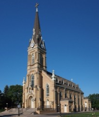 | Church of St. Michael-Catholic | 1.8 miles | 1979 |
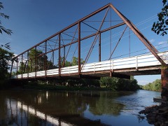 | Hanover Bridge | 5.7 miles | 1979 |
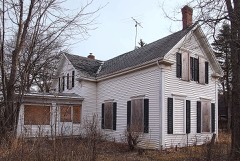 | Tobias G. Mealey House | 6.2 miles | 1976 |
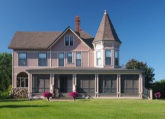 | Rufus Rand Summer House and Carriage Barn | 7.7 miles | 1979 |
| National Archives record | The nomination case file for reference 79001258 in Record Group 79. |
| Wright County | All 22 listed properties in this county. |