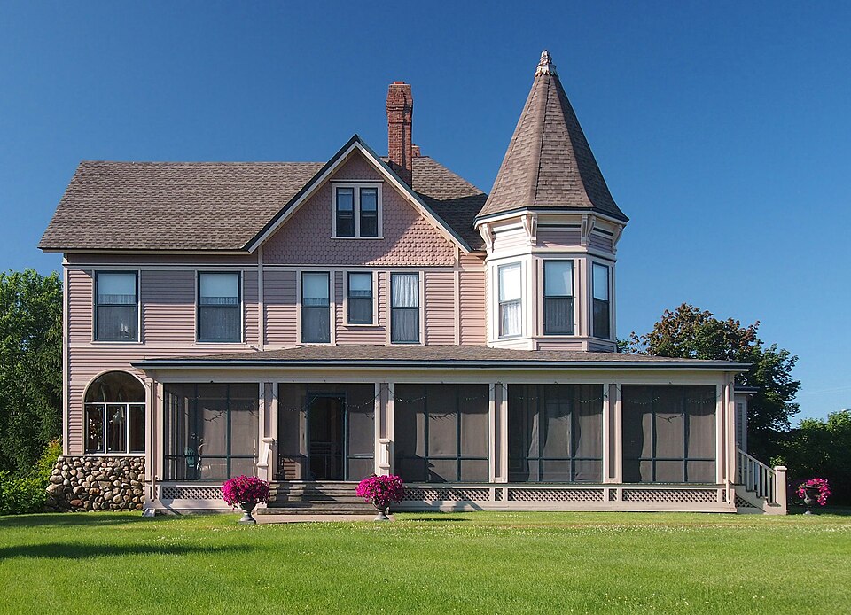
Listed on the National Register of Historic Places in 1979.
From the record
“The Rand House, nicknamed "Random", is a historic house in Monticello, Minnesota, United States, constructed in 1884 and operated as a bed and breakfast from the mid-1990s until 2020. It was the centerpiece of a summer estate owned by Minneapolis businessman Rufus Rand, Sr., and his wife Susan Mealey.”
Wikipedia article Rand House, CC BY-SA 4.0.
One of 22 National Register listings published here for Wright County · listed in 1979 · category: Building.
National Register reference number.79001275- the number the National Park Service assigned this property when it was listed, and the key its nomination file is catalogued under at the National Archives.
Monticello is an irregular shaped township on the Mississippi river in the northeastern part of the county. It embraces township 121, range 25, fractional township 122, range 25, and the west fractional half of township 121, range 24. It is bounded on the north by the Mississippi river, on the east by Otsego township, on the south by Frankfort and Buffalo townships, and on the west by Maple Lake and Silver Creek townships.
The first actual settlers were Herbert W. McCrory and Frederick M. Cadwell, who came to Monticello in the fall of 1852. Mr. MeCrory took a claim adjoining the upper limits of the present village. Mr, Cadwell took a claim two miles above Monticello, opposite Rawlin's Island, There he and Mr. MeCrory raised their first crops in the summer of 1853. Then he moved down and took another claim adjoining Mr. MecCrory's, just above the present townsite. Mr. Cadwell afterward moved to Albion, but later returned, and is now (June, 1915) living in the village of Monticello. Mr. MeCroxy moved to Kansas. In April, 1853, Ashley C. Riggs took a claim in lower Monticello, on what afterward became the townsite of Moritzious.
Regional context, not property-specific
evidence. The
federal wildfire occurrence database
lists 63 fires within 5 miles of Rufus Rand Summer House and Carriage Barn
between 1992 and 2018, burning about 86 acres in total. None started naturally. 9 were recorded as arson.
Distance is straight-line from the map coordinates, so a fire counted
here may appear on a neighbouring settlement's page as well.
Reported cause
Fires
Debris and open burning
19
Railroad operations and maintenance
15
Arson/incendiarism
9
Missing data/not specified/undetermined
8
Equipment and vehicle use
7
Smoking
3
Misuse of fire by a minor
1
Other causes
1
The most recent of
them, most recent first, with the day each was reported and the service
that recorded it.
Regional context, not property-specific
evidence. The federal mineral resources record lists
2 workings within 5 miles of Rufus Rand Summer House and Carriage Barn: 2 producers.
All of them still produce. What was taken out: Sand and Gravel, Construction. Distance is straight-line from the
map coordinates, so a quarry counted here may appear on a neighbouring
settlement's page as well.
Regional context, not property-specific
evidence. The National Weather Service names
Monticello, the town this property stands in, in 74 storm reports between 1995 and 2024: 39 hail, 24 thunderstorm wind, 3 lightning, 2 tornado.
The reports record 2 injuries. Each account below is quoted exactly as the forecast office
filed it, from the NOAA Storm Events Database, and each date
opens the federal record of that event.
While several tornadoes converged on the southern edge of town, hurricane force winds battered the northern portions. The intersection of Interstate 94 and highway 25 was hardest hit by downburst winds resulting in extensive roof damage. Every tree in Ellison Park damaged. Roof ripped off automobile dealership flung into new car area destroying 75 new cars and trucks. Numerous recreational vehicles at RV dealership totaled. Over 200 structures significantly damaged. 61 homes and apartment buildings declared uninhabitable. 30 factories closed. Northern States Power transmission towers blown down. 2500 trees lost. Air conditioning unit blown off high school roof. Parked truck blown two thirds of a block. $100 million dollars damage estimate in Wright county. Called worst storm in 60 year history of Wright-Hennepin Cooperative Electric Association.
The Wright County Sheriffs Office said that several people had to be evacuated from their homes, and three townhouses were damaged in the fire-related lightning strike. The lightning struck a home and spread to three different townhouses near the area. No one was injured.
The ramp from southbound Highway 25, to eastbound Interstate 94 was completed flooded. One car was stranded and had to be towed due to the flooded roadway.
Lightning struck a TV antenna on top of a house on Meadow Lane. The bolt traveled into the garage where it started a fire. After the roof of the garage caught fire, the flames moved onto the roof of the home and produced significant damage.
Torrential rain produced over four inches of rain in less than two hours. Two county roads northwest of Monticello were covered with water, and intersections in Monticello were flooded with water two feet deep. Streets and intersections flooded in Albertville and St. Michael.
No historic map-sheet match is published
for this property yet. That does not mean no map exists. This record needs
a coordinate-quality review before it can be joined to a sheet boundary.
Browse the county's mapped places while that work is
pending.
Listed places nearby
4 within 8 miles
Other National Register properties close
enough to walk or drive between, ordered by distance from this one. Both
positions come from the same geocoding pass that matched these properties
to their map sheets.
Listing record. National Park Service National Register of Historic Places, listed-properties dataset, current to 2026-05-22.
Map join. Address geocoded through the United States Census geocoder, then tested against the published boundary of every sheet in the USGS Historical Topographic Map Collection.
How this page is made. Listing fields come from federal records; map-sheet coverage is a labelled coordinate-to-boundary calculation, not a source-field claim.
Wildfire. Short, Karen C. 2022. Spatial wildfire occurrence data for the United States, 1992-2020 [FPA_FOD_20221014]. 6th Edition. Fort Collins, CO: Forest Service Research Data Archive. https://doi.org/10.2737/RDS-2013-0009.6 Collected with United States Government funding and usable without additional permissions or fees.
Mines and quarries. USGS Mineral Resources Data System (MRDS) https://mrdata.usgs.gov/mrds/ A work of the United States government, no copyright under 17 U.S.C. 105.
Storms. NOAA National Centers for Environmental Information, Storm Events Database https://www.ncei.noaa.gov/stormevents/ A work of the United States government, no copyright under 17 U.S.C. 105. Narratives are quoted verbatim from the National Weather Service report and are not edited or summarised.
 Block