BlockBefore
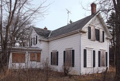
Photograph of David Hanaford Farmstead
Photograph by Bobak Ha'Eri, CC BY 3.0. Via Wikimedia Commons.

David Hanaford Farmstead

Listed on the National Register of Historic Places in 1979.

From the record

“The David Hanaford Farmstead is a historic farm in Monticello Township, Minnesota, United States. It was first settled in 1855 and features a farmhouse built in 1870 and a barn from around the same time.”

Wikipedia article David Hanaford Farmstead, CC BY-SA 4.0.

One of 22 National Register listings published here for Wright County · listed in 1979 · category: District.

Sources: the Wikipedia article · the case file at the National Archives · the National Register database, National Park Service

The listing

  • What is counted as historic. The nomination lists 7 buildingss, 5 sitess as contributing to the listing.
  • Listed as. Hanaford, David, Farmstead - the National Register files a house under its owner's surname.
  • Address. Off Co. Hwy. 106, Monticello, 55362
  • When was it listed? December 1979
  • Category. district
  • Also known as. Wright County MRA
  • Township. Monticello township
  • Architectural style. Federal architecture
  • National Register reference number. 79001273 - the number the National Park Service assigned this property when it was listed, and the key its nomination file is catalogued under at the National Archives.

Fires near this property

10 since 1994

Regional context, not property-specific evidence. The federal wildfire occurrence database lists 10 fires within 5 miles of David Hanaford Farmstead between 1994 and 2010, burning about 6 acres in total. None started naturally. 1 was recorded as arson. Distance is straight-line from the map coordinates, so a fire counted here may appear on a neighbouring settlement's page as well.

Reported cause Fires
Debris and open burning3
Smoking2
Equipment and vehicle use2
Railroad operations and maintenance1
Missing data/not specified/undetermined1
Arson/incendiarism1

The most recent of them, most recent first, with the day each was reported and the service that recorded it.

DateCause SizeReported by Name on the report
4 June 1994Smoking2.0 acresMinnesota Department of Natural Resourcesnot named
25 June 1996Railroad operations and maintenanceunder an acreMinnesota Department of Natural Resourcesnot named
19 May 1997Debris and open burningunder an acreMinnesota Department of Natural Resourcesnot named
18 May 2002Debris and open burningunder an acreMinnesota Department of Natural Resourcesnot named
12 May 2007Equipment and vehicle useunder an acreMinnesota Department of Natural Resourcesnot named
16 April 2008Debris and open burningunder an acreMinnesota Department of Natural Resourcesnot named
16 April 1998Arson/incendiarismunder an acreMinnesota Department of Natural Resourcesnot named
11 April 2010Smokingunder an acreMinnesota Department of Natural Resourcesnot named

Every fire recorded in Wright County

Mines and quarries near this property

3 within 5 miles

Regional context, not property-specific evidence. The federal mineral resources record lists 3 workings within 5 miles of David Hanaford Farmstead: 2 producers, 1 past producer. 2 still produce. What was taken out: Sand and Gravel, Construction. Distance is straight-line from the map coordinates, so a quarry counted here may appear on a neighbouring settlement's page as well.

Where SiteCommodity StatusRecorded
Barton Pit No 755Sand and Gravel, ConstructionProducer
Gullings PitSand and Gravel, ConstructionProducer
Munsterteiger PitSand and Gravel, ConstructionPast Producer

Every working recorded in Wright County

Storms near this property

60 of 74 shown

Regional context, not property-specific evidence. The National Weather Service names Monticello, the town this property stands in, in 74 storm reports between 1995 and 2024: 39 hail, 24 thunderstorm wind, 3 lightning, 2 tornado. The reports record 2 injuries. Each account below is quoted exactly as the forecast office filed it, from the NOAA Storm Events Database, and each date opens the federal record of that event.

WhenEvent Place namedHarm What the report says
July 2008LightningMonticello1 hurtMan struck and injured by lightning while accomplishing construction work on the roof of a home.
August 1995Thunderstorm WindMonticello1 hurtTree fell on house injuring one person.
July 1997Thunderstorm WindMonticello$20,000,000While several tornadoes converged on the southern edge of town, hurricane force winds battered the northern portions. The intersection of Interstate 94 and highway 25 was hardest hit by downburst winds resulting in extensive roof damage. Every tree in Ellison Park damaged. Roof ripped off automobile dealership flung into new car area destroying 75 new cars and trucks. Numerous recreational vehicles at RV dealership totaled. Over 200 structures significantly damaged. 61 homes and apartment buildings declared uninhabitable. 30 factories closed. Northern States Power transmission towers blown down. 2500 trees lost. Air conditioning unit blown off high school roof. Parked truck blown two thirds of a block. $100 million dollars damage estimate in Wright county. Called worst storm in 60 year history of Wright-Hennepin Cooperative Electric Association.
July 2016LightningMonticello$500,000The Wright County Sheriffs Office said that several people had to be evacuated from their homes, and three townhouses were damaged in the fire-related lightning strike. The lightning struck a home and spread to three different townhouses near the area. No one was injured.
July 2016Thunderstorm WindMonticello$250,000A pole barn was destroyed west of Monticello, on County Road 39.
July 2011Thunderstorm WindMonticello$15,000Several trees and power lines were blown down in Monticello, Minnesota.
July 2024HailMonticello-Additionally sent in a photo with hail size measurement.
June 2017Thunderstorm WindMonticello-Power lines and large branches were blown down via social media.
June 2017Thunderstorm WindMonticello-A cinder block dugout was destroyed at a high school ballpark.
July 2016Heavy RainMonticello-A trained spotter measured 3.75 inches of rain near Monticello.
July 2016Flash FloodMonticello-The ramp from southbound Highway 25, to eastbound Interstate 94 was completed flooded. One car was stranded and had to be towed due to the flooded roadway.
July 2016Heavy RainMonticello-A trained spotter measured 4.22 inches of rain east of Monticello.
July 2016Thunderstorm WindMonticello-A large 14 inch diameter tree was blown down between Buffalo and Monticello near Highway 25.
June 2013Thunderstorm WindMonticello-A large 30 inch diameter tree was blown down in Monticello, with other smaller trees blown down in Monticello as well.
September 2013HailMonticello-Quarter size hail was reported near interstate 94, and Highway 118.
July 2012Thunderstorm WindMonticello-A 22-inch diameter tree blew down near Monticello, Minnesota.
July 2011Thunderstorm WindMonticello-Several power poles were blown down near Monticello, Minnesota.
July 2011HailMonticello-Several reports of baseball size hail occurred in the city of Monticello, Minnesota.
August 2010Thunderstorm WindMonticello-A 14 inch diameter tree was uprooted near Monticello, Minnesota.
July 2010Thunderstorm WindMonticello-A trained spotter measured a wind gust of 70 mph.
July 2008Thunderstorm WindMonticello-Seventeen inch and fifteen inch diameter trees felled. A total of 5 trees downed.
July 2008Thunderstorm WindMonticello-Debris observed on road, large branches also felled.
July 2008HailMonticello-Hail occurred at intersection of 25th and 137th.
May 2008HailMonticello-Widespread damage to houses and vehicles.
June 2008Thunderstorm WindMonticello-Eleven inch diameter branches down.
July 2008Thunderstorm WindMonticello-Sixteen inch box elder tree toppled. Eighty pound dog house tossed 50 feet across yard.
May 2006HailMonticello-Ground covered with hail. Scattered leaves torn off trees.
June 2005LightningMonticello-Lightning struck a TV antenna on top of a house on Meadow Lane. The bolt traveled into the garage where it started a fire. After the roof of the garage caught fire, the flames moved onto the roof of the home and produced significant damage.
September 2005Flash FloodMonticello-Torrential rain produced over four inches of rain in less than two hours. Two county roads northwest of Monticello were covered with water, and intersections in Monticello were flooded with water two feet deep. Streets and intersections flooded in Albertville and St. Michael.
September 2005Thunderstorm WindMonticello-Siding ripped off some homes. Scattered trees and large branches down.
July 2003Thunderstorm WindMonticello-Numerous trees and power lines down.
June 2003Thunderstorm WindMonticello-Few trees down.
June 1999HailMonticello-Strong winds also blew scaffolding down at high school.
June 1999Thunderstorm WindMonticello-Large Tree toppled near home. Estimated wind speed.
June 1998Thunderstorm WindMonticello-Trees blown down. Estimated windspeed.
July 1997Tornado (F2)Monticello-Two tornadoes converged on the Prairie Acres housing development 1 south of Monticello at about the same time. Extensive damage in area.
August 1997Thunderstorm WindMonticello-Power line poles broken in half. Estimated windspeed.
July 2024HailMonticello-no account filed
July 2023HailMonticello-no account filed
April 2021HailMonticello-no account filed
June 2019HailMonticello-no account filed
July 2019HailMonticello-no account filed
March 2017HailMonticello-no account filed
July 2016Funnel CloudMonticello-no account filed
July 2016HailMonticello-no account filed
July 2011HailMonticello-no account filed
June 2010HailMonticello-no account filed
July 2008Funnel CloudMonticello-no account filed
May 2008HailMonticello-no account filed
June 2008Thunderstorm WindMonticello-no account filed
July 2007HailMonticello-no account filed
September 2007HailMonticello-no account filed
April 2007HailMonticello-no account filed
August 2006HailMonticello-no account filed

Every storm recorded in Wright County

Map coverage status

No historic map-sheet match is published for this property yet. That does not mean no map exists. This record needs a coordinate-quality review before it can be joined to a sheet boundary. Browse the county's mapped places while that work is pending.

Listed places nearby

3 within 8 miles

Other National Register properties close enough to walk or drive between, ordered by distance from this one. Both positions come from the same geocoding pass that matched these properties to their map sheets.

Photograph PropertyDistance Listed
Rufus Rand Summer House and Carriage Barn3.5 miles1979
Nicherson-Tarbox House, Shed and Barn3.6 miles1979
Tobias G. Mealey House5.7 miles1976

Sources for this property

National Archives recordThe nomination case file for reference 79001273 in Record Group 79.
Wikipedia articleCommunity-written account of this property, licensed CC BY-SA.
Wright CountyAll 22 listed properties in this county.

Provenance

  • Listing record. National Park Service National Register of Historic Places, listed-properties dataset, current to 2026-05-22.
  • Map join. Address geocoded through the United States Census geocoder, then tested against the published boundary of every sheet in the USGS Historical Topographic Map Collection.
  • How this page is made. Listing fields come from federal records; map-sheet coverage is a labelled coordinate-to-boundary calculation, not a source-field claim.
  • Wildfire. Short, Karen C. 2022. Spatial wildfire occurrence data for the United States, 1992-2020 [FPA_FOD_20221014]. 6th Edition. Fort Collins, CO: Forest Service Research Data Archive. https://doi.org/10.2737/RDS-2013-0009.6 Collected with United States Government funding and usable without additional permissions or fees.
  • Mines and quarries. USGS Mineral Resources Data System (MRDS) https://mrdata.usgs.gov/mrds/ A work of the United States government, no copyright under 17 U.S.C. 105.
  • Storms. NOAA National Centers for Environmental Information, Storm Events Database https://www.ncei.noaa.gov/stormevents/ A work of the United States government, no copyright under 17 U.S.C. 105. Narratives are quoted verbatim from the National Weather Service report and are not edited or summarised.