BlockBefore
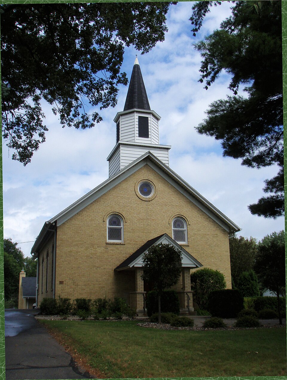
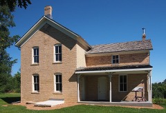
Photograph of Laketown Moravian Brethren's Church
Photograph by Elkman, CC BY-SA 3.0. Via Wikimedia Commons.

Laketown Moravian Brethren's Church

Listed on the National Register of Historic Places in 1980.

From the record

“Laketown Moravian Brethren's Church is a historic church on County Highway 11 in Victoria, Minnesota, United States.”

Wikipedia article Laketown Moravian Brethren's Church, CC BY-SA 4.0.

One of 35 National Register listings published here for Carver County · listed in 1980 · category: Building.

Sources: the Wikipedia article · the case file at the National Archives · the National Register database, National Park Service · the Wikipedia article

The listing

  • What is counted as historic. The nomination lists 1 building as contributing to the listing.
  • Address. Co. Hwy. 11, Victoria, 55386
  • When was it listed? January 1980
  • Category. building
  • Also known as. Carver County MRA
  • City. Victoria city
  • National Register reference number. 80001981 - the number the National Park Service assigned this property when it was listed, and the key its nomination file is catalogued under at the National Archives.

Fires near this property

1 since 2010

Regional context, not property-specific evidence. The federal wildfire occurrence database lists 1 fire within 5 miles of Laketown Moravian Brethren's Church in 2010, burning about 85 acres in total. None started naturally. None was recorded as arson. Distance is straight-line from the map coordinates, so a fire counted here may appear on a neighbouring settlement's page as well.

Reported cause Fires
Recreation and ceremony1

The most recent of them, most recent first, with the day each was reported and the service that recorded it.

DateCause SizeReported by Name on the report
11 April 2010Recreation and ceremony85 acresMinnesota Department of Natural Resourcesnot named

Every fire recorded in Carver County

Storms near this property

29 since 1994

Regional context, not property-specific evidence. The National Weather Service names Victoria, the town this property stands in, in 29 storm reports between 1994 and 2025: 13 hail, 9 thunderstorm wind, 4 heavy rain, 1 funnel cloud. No death or injury is recorded in these reports. Each account below is quoted exactly as the forecast office filed it, from the NOAA Storm Events Database, and each date opens the federal record of that event.

WhenEvent Place namedHarm What the report says
May 1998Thunderstorm WindVictoria$5,000,000Windows broken. Trees blown down. Partial structural damage to building. Scattered areas damaged to wind driven hail. Estimated windspeed. Damage estimate for entire county.
August 2020HailVictoria$500,000Numerous sources from social media pictures, to trained spotters and official NWS observations, reported and measured very large hail for nearly 40 minutes from Victoria, eastward to the Carver, Hennepin County line. This includes some of the smaller communities between the two towns. ||The largest hailstone was measured at 2.75 inches in diameter and fell near Victoria. Two inch hail was measured at the NWS office. Due to the large hail size and almost a continuous line of storms redeveloping in the same areas, many roofs and cars were damaged.
August 2017LightningVictoria$200,000A home in Chanhassen, Minnesota was severely damaged after a fire broke out in the attic. It was caused by a lightning strike and happened on the 4000 block of Leslie Curve just before 12:30 a.m. LST. Fire officials said the heavy rain made it difficult to put the fire out. No one was hurt.
August 2021Thunderstorm WindVictoria$20,000A pontoon boat was flipped over and docks were damaged on Lake Minnewashta. In addition, several large trees were blown down.
August 2022Thunderstorm WindVictoria$500Several large tree branches were blown down around Victoria.
August 2025HailVictoria-Hail was continuous for roughly 3 minutes and the average size of the hail was 1 inch in diameter. The largest hail stone was 1.25 inches in diameter.
June 2025HailVictoria-A lot of hail up to ping pong size in Victoria.
June 2025Tornado (EF1)Victoria-The tornado touchdown likely occurred in the northern part of Carver Park Reserve before tracking across portions of Stone Lake and Lake Zumbra. Tree damage occurred along the shores of Lake Zumbra & residences on Zumbra Drive. The most extensive tree damage occurred at Rolling Acres Rd and Highway 7 where numerous trees were uprooted or were broken. The tornado terminated over Lake Minnewashta. The maximum estimated winds were 90 mph.
August 2024Thunderstorm WindVictoria-Tree down and power line down blocking one lane of Hwy 5 near the Arboretum east of Victoria.
August 2024Thunderstorm WindVictoria-Large tree was down in Victoria.
August 2024Thunderstorm WindVictoria-Multiple large tree branches were down.
August 2020Heavy RainVictoria-A measured rainfall report of 4.52 inches in Victoria.
June 2017Thunderstorm WindVictoria-A few large branches were blown down.
June 2014Heavy RainVictoria-A 24 hour rainfall total of 4.23 inches was reported.
May 2012Heavy RainVictoria-A local observer measured 3.18 inches in the last 24 hours.
August 2012Thunderstorm WindVictoria-Multiple tents were blown over at a campground in Carver.
August 2009Heavy RainVictoria-The local COOP Observer in Chaska recorded 6.20 inches of rainfall in a six hour period.
August 2007Thunderstorm WindVictoria-Dozens of trees felled in the Lake Schutz area. Some trees fell on houses and sheds.
May 2004HailVictoria-Dime sized hail fell at Deer Run Golf Course.
August 2025HailVictoria-no account filed
July 2019HailVictoria-no account filed
June 2016HailVictoria-no account filed
May 2012HailVictoria-no account filed
June 2008HailVictoria-no account filed
September 2005HailVictoria-no account filed
June 1996Funnel CloudVictoria-no account filed
June 1994HailVictoria-no account filed

Every storm recorded in Carver County

Map coverage status

No historic map-sheet match is published for this property yet. That does not mean no map exists. This record needs a coordinate-quality review before it can be joined to a sheet boundary. Browse the county's mapped places while that work is pending.

Listed places nearby

6 within 8 miles

Other National Register properties close enough to walk or drive between, ordered by distance from this one. Both positions come from the same geocoding pass that matched these properties to their map sheets.

Photograph PropertyDistance Listed
Andrew Peterson Farmstead2.4 miles1979
Wendelin Grimm Farmstead2.4 miles1974
Zoar Moravian Church4.3 miles1980
Coney Island of the West5.2 miles1976
Charles Maiser House5.5 miles1980
Mock Cigar Factory and House5.5 miles1980

Sources for this property

National Archives recordThe nomination case file for reference 80001981 in Record Group 79.
Wikipedia articleCommunity-written account of this property, licensed CC BY-SA.
Carver CountyAll 35 listed properties in this county.

Provenance

  • Listing record. National Park Service National Register of Historic Places, listed-properties dataset, current to 2026-05-22.
  • Map join. Address geocoded through the United States Census geocoder, then tested against the published boundary of every sheet in the USGS Historical Topographic Map Collection.
  • How this page is made. Listing fields come from federal records; map-sheet coverage is a labelled coordinate-to-boundary calculation, not a source-field claim.
  • Wildfire. Short, Karen C. 2022. Spatial wildfire occurrence data for the United States, 1992-2020 [FPA_FOD_20221014]. 6th Edition. Fort Collins, CO: Forest Service Research Data Archive. https://doi.org/10.2737/RDS-2013-0009.6 Collected with United States Government funding and usable without additional permissions or fees.
  • Storms. NOAA National Centers for Environmental Information, Storm Events Database https://www.ncei.noaa.gov/stormevents/ A work of the United States government, no copyright under 17 U.S.C. 105. Narratives are quoted verbatim from the National Weather Service report and are not edited or summarised.