 Block
From the record
One of 22 National Register listings published here for Clay County · listed in 1980 · category: Building.
Sources: the case file at the National Archives · the National Register database, National Park Service
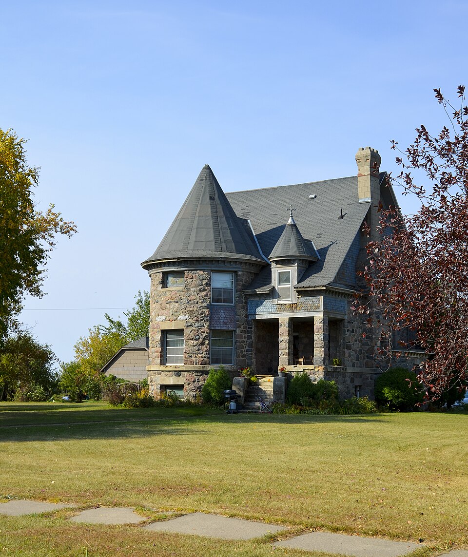
Listed on the National Register of Historic Places in 1980.
One of 22 National Register listings published here for Clay County · listed in 1980 · category: Building.
Sources: the case file at the National Archives · the National Register database, National Park Service
Regional context, not property-specific evidence. The federal mineral resources record lists 6 workings within 5 miles of Patterson-Hernandez House: 6 producers. All of them still produce. What was taken out: Sand and Gravel, Construction. Distance is straight-line from the map coordinates, so a quarry counted here may appear on a neighbouring settlement's page as well.
| Where | Site | Commodity | Status | Recorded |
|---|---|---|---|---|
| Barth Pit | Sand and Gravel, Construction | Producer | ||
| Hollands Pit | Sand and Gravel, Construction | Producer | ||
| Mallinger Pit | Sand and Gravel, Construction | Producer | ||
| Quinnild Pit No 1 | Sand and Gravel, Construction | Producer | ||
| Quinnild Pit No 2 | Sand and Gravel, Construction | Producer | ||
| Skree Pit No 2 | Sand and Gravel, Construction | Producer |
Regional context, not property-specific evidence. The National Weather Service names Barnesville, the town this property stands in, in 42 storm reports between 1993 and 2025: 19 thunderstorm wind, 15 hail, 6 flash flood, 1 tornado. No death or injury is recorded in these reports. Each account below is quoted exactly as the forecast office filed it, from the NOAA Storm Events Database, and each date opens the federal record of that event.
| When | Event | Place named | Harm | What the report says |
|---|---|---|---|---|
| July 2020 | Lightning | Barnesville | $250,000 | Lightning ignited a house fire, destroying the home. |
| May 1996 | Thunderstorm Wind | Barnesville | $50,000 | no account filed |
| June 1999 | Thunderstorm Wind | Barnesville | $10,000 | A tree was blown over onto a house. |
| July 2010 | Flash Flood | Barnesville | $5,000 | Nearly three inches of rain fell, causing flooding in low spots. Local sloughs and creeks also filled with water and overspilled their banks. |
| September 2014 | Flash Flood | Barnesville | $3,000 | Several bouts of heavy rainfall flooded city streets. Water was reported to be over a foot deep in some areas. |
| July 2016 | Flash Flood | Barnesville | $2,000 | Fields and farm access roads were flooded near Stoney Creek and across northern Humboldt and southern Skree townships. |
| August 2000 | Thunderstorm Wind | Barnesville | $500 | Large branches were blown down. |
| June 2025 | Hail | Barnesville | - | Hail reported via ice-chip research team. |
| June 2025 | Hail | Barnesville | - | Reported via ice-chip research team. |
| May 2024 | Thunderstorm Wind | Barnesville | - | Delayed report from social media; shed flipped over fence. Time estimated based on radar and surrounding obs with an RWIS gusting to 57 mph 10 minutes later about 13 miles ESE as the gust front hit that location. |
| September 2023 | Hail | Barnesville | - | Broadcast Media relays report of 1.75-inch hail in Barnesville. |
| May 2022 | Thunderstorm Wind | Barnesville | - | A peak wind of 58 mph was measured at a personal weather station. |
| June 2021 | Thunderstorm Wind | Barnesville | - | Peak wind gust of 67 mph measured at a personal weather station. |
| July 2021 | Thunderstorm Wind | Barnesville | - | Received reports from two different wind sensors in the Barnesville area with wind gusts to 60 mph between 0136 and 0144 CDT. A few large tree branches were broken down around town as reported by a trained spotter. |
| July 2020 | Thunderstorm Wind | Barnesville | - | Large tree branches were blown down. |
| June 2020 | Thunderstorm Wind | Barnesville | - | Large branches were blown down in a farm yard. |
| July 2019 | Thunderstorm Wind | Barnesville | - | The wind gusts were measured by a personal weather station. |
| July 2018 | Thunderstorm Wind | Barnesville | - | Tree were snapped and uprooted around Barnesville. A barn was partially blown off its foundation and collapsed. |
| July 2018 | Thunderstorm Wind | Barnesville | - | The strong winds were measured by a personal weather station. |
| June 2018 | Thunderstorm Wind | Barnesville | - | Six to seven trees were blown down, the largest one had a 9 inch diameter. |
| June 2016 | Thunderstorm Wind | Barnesville | - | Several twelve inch diameter poplar trees and an eighteen inch diameter cottonwood tree were snapped in shelterbelts near the Clay and Wilkin county line. |
| June 2013 | Tornado (EF0) | Barnesville | - | The tornado touched down about a mile west of the airport and tracked to the Interstate 94 exit north of town by 2230 CST. The tornado continued to about four miles northeast of town, a track length of about seven miles. The tornado was likely wrapped in heavy rain during portions of this track. One livestock loafing shed was lifted and collapsed and several trees were knocked down. Peak winds were estimated at 80 mph. |
| July 2012 | Hail | Barnesville | - | The hail ranged from dime to golfball size. |
| July 2011 | Thunderstorm Wind | Barnesville | - | Wind gusts were estimated up to 60 mph. |
| July 2010 | Thunderstorm Wind | Barnesville | - | A large tree was blown down next to the firehouse. A lot of smaller branches were also blown off trees around town. |
| July 2010 | Thunderstorm Wind | Barnesville | - | A small ride at the Clay County fair was damaged due to strong winds. |
| June 2007 | Thunderstorm Wind | Barnesville | - | Trees were blown down in a shelterbelt near the Clay and Wilkin County line. |
| May 2004 | Flash Flood | Barnesville | - | [See the event description under the Lawndale, Wilkin county, flash flood event.] |
| July 2002 | Flash Flood | Barnesville | - | A highway underpass was flooded. |
| August 1993 | Thunderstorm Wind | Barnesville | - | Strong thunderstorm winds blew down a barn and a shed was destroyed. |
| July 2022 | Hail | Barnesville | - | no account filed |
| September 2014 | Hail | Barnesville | - | no account filed |
| May 2004 | Hail | Barnesville | - | no account filed |
| May 2004 | Hail | Barnesville | - | no account filed |
| May 2004 | Hail | Barnesville | - | no account filed |
| May 2004 | Hail | Barnesville | - | no account filed |
| May 2004 | Hail | Barnesville | - | no account filed |
| May 2004 | Hail | Barnesville | - | no account filed |
| May 2004 | Hail | Barnesville | - | no account filed |
| August 2004 | Hail | Barnesville | - | no account filed |
| August 2002 | Hail | Barnesville | - | no account filed |
| April 2001 | Flash Flood | Barnesville | - | no account filed |
No historic map-sheet match is published for this property yet. That does not mean no map exists. This record needs a coordinate-quality review before it can be joined to a sheet boundary. Browse the county's mapped places while that work is pending.
Other National Register properties close enough to walk or drive between, ordered by distance from this one. Both positions come from the same geocoding pass that matched these properties to their map sheets.
| Photograph | Property | Distance | Listed |
|---|---|---|---|
 | Barnesville City Hall and Jail | 0.2 miles | 1980 |
 | Hannah C. and Peter E. Thompson House | 0.6 miles | 1996 |
| National Archives record | The nomination case file for reference 80002010 in Record Group 79. |
| Clay County | All 22 listed properties in this county. |