BlockBefore
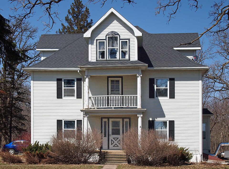
Photograph of Holden Lutheran Church Parsonage
Photograph by McGhiever, CC BY-SA 3.0. Via Wikimedia Commons.

Holden Lutheran Church Parsonage

Listed on the National Register of Historic Places in 1980.

From the record

“Holden Lutheran Church Parsonage is a historic church parsonage at Kenyon in Wanamingo Township, Goodhue County, Minnesota. The building is located on the north side of Goodhue County Highway 8.”

Wikipedia article Holden Lutheran Church Parsonage, CC BY-SA 4.0.

One of 60 National Register listings published here for Goodhue County · listed in 1980 · category: Building.

Sources: the Wikipedia article · the case file at the National Archives · the National Register database, National Park Service


The listing

  • What is counted as historic. The nomination lists 1 building as contributing to the listing.
  • Address. Co. Hwy. 60, Kenyon, 55946
  • When was it listed? February 1980
  • Category. building
  • Also known as. Rural Goodhue County MRA
  • Township. Wanamingo township
  • National Register reference number. 80002049 - the number the National Park Service assigned this property when it was listed, and the key its nomination file is catalogued under at the National Archives.

The ground it stands on

2,075 words

The chapter on Wanamingo Township in Goodhue County, Minnesota, Past and Present, published 1893 names Kenyon. This is what it says, exactly as the scans read.

This last party consisted of Andres Baarnhus and his family, John Stroemme and family, Kolben Ektevest and family, Gunder Hestemyr, Ole O. Oakland, Haldor Johnson, also having their families. About the first of August another train of Norwegian immigrants came on from Wisconsin, but finding the township of Wanamingo already claimed, they went further west into Holden and Kenyon, some even beyond the county line west, to make claims.

Passage source: Goodhue County, Minnesota, Past and Present, published 1893.

Machine-read from a century-old scan, so expect the errors a machine makes: misspelled names, dropped words, stray characters.

Read the whole chapter on Wanamingo Township - 2,075 words on its settlement, mills, schools and churches.

Mines and quarries near this property

3 within 5 miles

Regional context, not property-specific evidence. The federal mineral resources record lists 3 workings within 5 miles of Holden Lutheran Church Parsonage: 3 producers. All of them still produce. What was taken out: Stone, Crushed/Broken, Sand and Gravel, Construction. Distance is straight-line from the map coordinates, so a quarry counted here may appear on a neighbouring settlement's page as well.

Where SiteCommodity StatusRecorded
Anderson Sand & Gravel PitSand and Gravel, ConstructionProducer
County QuarryStone, Crushed/BrokenProducer
Wacobson QuarryStone, Crushed/BrokenProducer

Every working recorded in Goodhue County

Storms near this property

33 since 1995

Regional context, not property-specific evidence. The National Weather Service names Kenyon, the town this property stands in, in 33 storm reports between 1995 and 2025: 17 thunderstorm wind, 8 hail, 3 tornado, 2 heavy rain. No death or injury is recorded in these reports. Each account below is quoted exactly as the forecast office filed it, from the NOAA Storm Events Database, and each date opens the federal record of that event.

WhenEvent Place namedHarm What the report says
June 2012Thunderstorm WindKenyon$250,000There were numerous reports of trees snapped, power lines and barns blown down, with injuries to livestock from Kenyon to Wanamingo and Zumbrota.
July 2022Thunderstorm WindKenyon$5,000Several large trees were blown down in Kenyon, including some taking down power lines.
April 2025Thunderstorm WindKenyon-Photos of roof damage to large commercial warehouse in Kenyon.
September 2024HailKenyon-Lots of hail occurred, with the largest being ping pong ball size.
September 2024HailKenyon-There were several reports of quarter to half dollar sized hail in Kenyon.
June 2024Thunderstorm WindKenyon-Several 14 to 24 inch diameter trees were downed.
August 2023Thunderstorm WindKenyon-Various trees and branches were reported down in and around Kenyon.
July 2023HailKenyon-Mix of quarter to half-dollar sized hail. Picture via Twitter.
May 2020Thunderstorm WindKenyon-A large tree limb was blown down at the corner of Red Wing Avenue and 1st Street.
September 2018Tornado (EF1)Kenyon-This is the continued tornado track from the Rice County tornado that moved an additional 1.4 miles northeast into Goodhue County. A storm survey, and high resolution satellite imagery, concluded that damage was associated with flattened corn and soy bean fields, and a loss of a silo's roof panel. The damage is consistent with EF1 damage with winds up to 90 mph, and a width of 100 yards.
August 2018Tornado (EF0)Kenyon-A storm survey determined that a tornado started just east of Nerstrand MN (in Rice County) and continued into Goodhue County, where is dissipated. It damaged trees and crops.
June 2016Thunderstorm WindKenyon-A social media video showed several large trees branches blown down, and a couple of large diameter trees uprooted near Kenyon. A local farm noted that their corn had been flattened near Kenyon.
June 2016Thunderstorm WindKenyon-A 8 inch diameter tree branch was blown across Highway 56, south of Kenyon.
September 2016Heavy RainKenyon-A local trained weather observer measured 5.16 inches of rainfall near Kenyon between Wednesday afternoon, September 21st, to the early morning of Thursday, September 22nd.
September 2016FloodKenyon-Runoff from torrential rainfall that occurred across most of southern Goodhue County Wednesday night, September 21st, caused numerous roads to remain impassable and closed.
July 2013Flash FloodKenyon-Several areas in the town of Kenyon had over six inches of flowing water in streets and county roads. This water drained into the Zumbro River system. Very heavy rain also fell to the north of Kenyon, in Holden Township, and this water drained into the Cannon River system. Eventually, there was high water on both the Cannon and Zumbro Rivers.
June 2012Heavy RainKenyon-A measured rainfall report of 4.54 inches occurred in less than 18 hours.
July 2007Thunderstorm WindKenyon-Few trees and power lines down.
August 2007Thunderstorm WindKenyon-Downed power lines.
August 2006HailKenyon-A two to three mile wide swath of very large hail extended from Northfield in Rice County to Wanamingo in Goodhue County. About 40,000 acres of crops were damaged or destroyed in Goodhue County. Vehicles, homes and businesses damaged. Damage total includes all storm reports from August 24 in Goodhue County.
June 2005Thunderstorm WindKenyon-Two trees were downed. One tree fell onto a garage.
June 2005Thunderstorm WindKenyon-Along 430th Street in Holden Township, Section 23, a large commodity shed was destroyed after 5 support beams were ripped from the structure. One of the beams was thrown 75 feet and the roof of the structure fell onto a tractor. Doors on two free standing barns were also damaged. In addition, a very large Maple tree that was estimated to be over 100 years old was felled.
June 2005HailKenyon-A newspaper published a picture of hail that fell in Kenyon that looked to be at least 1.25 inches in diameter.
July 2002Thunderstorm WindKenyon-Numerous trees down, chimney toppled.
August 2002Thunderstorm WindKenyon-Few trees and power lines down.
June 1998Thunderstorm WindKenyon-Trees down. Estimated windspeed. Also received 5 inches of rain.
May 1998Thunderstorm WindKenyon-Trees blown down. Estimated windspeed.
June 1995Thunderstorm WindKenyon-Large tree toppled by strong thunderstorm winds at Kenyon Country Club at 1657 CST. Four inches of rain flooded Highway 60 1.5 miles east of Kenyon. Water washed out part of the north shoulder and traffic was reduced to one lane. Kenyon Golf Course received three and one-half inches of rain in one hour. Five fairways that run parallel with the Zumbro River were flooded.
August 2007HailKenyon-no account filed
July 2007HailKenyon-no account filed
August 2006HailKenyon-no account filed
August 1999Funnel CloudKenyon-no account filed
June 1998Tornado (F0)Kenyon-no account filed

Every storm recorded in Goodhue County

Map coverage status

No historic map-sheet match is published for this property yet. That does not mean no map exists. This record needs a coordinate-quality review before it can be joined to a sheet boundary. Browse the county's mapped places while that work is pending.

Listed places nearby

4 within 8 miles

Other National Register properties close enough to walk or drive between, ordered by distance from this one. Both positions come from the same geocoding pass that matched these properties to their map sheets.

Photograph PropertyDistance Listed
Nansen Agricultural Historic District3.8 miles2000
Martin T. Gunderson House5.7 miles1975
Church of St. Rose of Lima7.3 miles2013
Hauge Lutheran Church7.4 miles1980

Sources for this property

National Archives recordThe nomination case file for reference 80002049 in Record Group 79.
Wikipedia articleCommunity-written account of this property, licensed CC BY-SA.
Goodhue CountyAll 60 listed properties in this county.

Provenance

  • Listing record. National Park Service National Register of Historic Places, listed-properties dataset, current to 2026-05-22.
  • Map join. Address geocoded through the United States Census geocoder, then tested against the published boundary of every sheet in the USGS Historical Topographic Map Collection.
  • How this page is made. Listing fields come from federal records; map-sheet coverage is a labelled coordinate-to-boundary calculation, not a source-field claim.
  • Mines and quarries. USGS Mineral Resources Data System (MRDS) https://mrdata.usgs.gov/mrds/ A work of the United States government, no copyright under 17 U.S.C. 105.
  • Storms. NOAA National Centers for Environmental Information, Storm Events Database https://www.ncei.noaa.gov/stormevents/ A work of the United States government, no copyright under 17 U.S.C. 105. Narratives are quoted verbatim from the National Weather Service report and are not edited or summarised.