
BlockBefore
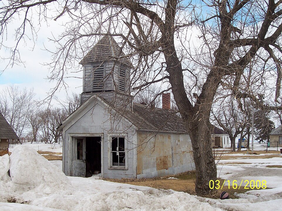
Photograph of Tenney Fire Hall
Photograph by Brain Rodeo, Public domain. Via Wikimedia Commons.

Tenney Fire Hall

Listed on the National Register of Historic Places in 1980.

From the record

“The Tenney Fire Hall was a historic fire station in Tenney, Minnesota, United States, built in 1904, but which burned down in 2010. It was listed on the National Register of Historic Places in 1980 for having local significance in the theme of politics/government.”

Wikipedia article Tenney Fire Hall, CC BY-SA 4.0.

One of 7 National Register listings published here for Wilkin County · listed in 1980 · category: Building.

Sources: the Wikipedia article · the National Register database, National Park Service

The listing

  • Listing status. The Park Service records this property as Removed.
  • What is counted as historic. The nomination lists 1 building as contributing to the listing.
  • Address. Concord Ave., Tenney, 56583
  • When was it listed? July 1980
  • Category. building
  • Also known as. Wilkin County MRA
  • Township. Campbell township
  • National Register reference number. 80002186 - assigned by the National Park Service when the property was listed.

Storms near this property

31 since 1998

Regional context, not property-specific evidence. The National Weather Service names Tenney, the town this property stands in, in 31 storm reports between 1998 and 2022: 17 thunderstorm wind, 6 hail, 3 flash flood, 3 tornado. No death or injury is recorded in these reports. Each account below is quoted exactly as the forecast office filed it, from the NOAA Storm Events Database, and each date opens the federal record of that event.

WhenEvent Place namedHarm What the report says
June 2017Thunderstorm WindTenney$500,000Several large grain bins were caved in by the strong wind and a couple of empty grain cars were blown over.
July 2011Thunderstorm WindTenney$20,000A few large trees were blown down at a farmstead. Wind damage continued intermittently through Tenney to Nashua, and across southern Campbell and Champion townships.
July 2002Thunderstorm WindTenney$10,000A power pole was snapped and trees damaged.
July 2002Thunderstorm WindTenney$200Branches were blown down.
May 2022Tornado (EF2)Tenney-This tornado began at approximately 716 pm about 1 mile southwest of Tenney, MN, then tracked to the north where it lifted 3 miles north of Campbell, MN. This tornado was best marked by the trail of at least 23 power poles which were cracked or completely snapped along it's, route. Widespread tree damage and large steel grain bins at the Campbell elevator complex were partially caved in. Peak winds were estimated at 115 mph, equating to an EF2 rating. The path length was 9 miles.
July 2020Thunderstorm WindTenney-The wind gust was measured by a RWIS mesonet sensor.
July 2020Thunderstorm WindTenney-The wind gust was measured by a RWIS mesonet station.
July 2020Thunderstorm WindTenney-The wind gust was measured by a personal weather station.
July 2020HailTenney-A lot of hail fell, resulting in piles in the yard.
September 2019Thunderstorm WindTenney-The wind gust was measured by a MNDOT RWIS sensor.
June 2016Funnel CloudTenney-A photo and video of the funnel cloud were posted on social media. These images showed a persistent wall cloud with a brief funnel.
August 2016Thunderstorm WindTenney-The wind gust was measured at the Tenney RWIS, near highway 75.
August 2012Thunderstorm WindTenney-The wind gust was measured at the MNDOT RWIS site along highway 75.
May 2012HailTenney-Nickel sized hail fell at the intersection of highways 55 and 75.
August 2010Tornado (EF0)Tenney-This tornado touched down briefly in an open field, roughly seven miles east of a larger and much longer lasting tornado.
June 2009Funnel CloudTenney-A wall cloud and a funnel were reported by a storm chaser. It appeared that the funnel was strengthening at the time.
June 2009Thunderstorm WindTenney-The wind gust was measured at the MNDOT RWIS site near Tenney on highway 75.
June 2009Tornado (EF0)Tenney-A brief tornado touchdown was reported near the Wilkin and Traverse County line. The tornado tracked for roughly a mile across open fields. Peak winds were estimated at 80 mph.
September 2008Flash FloodTenney-Heavy rains produced local 3 to 4 inch accumulations through the early morning hours. Several farm fields and some farm access roads were reported underwater in portions of Campbell West and Campbell East Townships.
May 2007Flash FloodTenney-Several rural and farm access roads were flooded by the heavy rain. 3 to 4 inches of rain fell in a short amount of time.
June 2005Thunderstorm WindTenney-Large tree branches were blown down and power lines were knocked down. Scattered power outages were also reported.
June 2005Flash FloodTenney-Ditches were full with fields and farm yards flooded.
August 2005Thunderstorm WindTenney-Power lines were blown down in southern Wilkin county. The power was knocked out to the MNDOT RWIS site near Tenney.
August 2005Thunderstorm WindTenney-Strong winds snapped trees and downed power lines.
July 2003Thunderstorm WindTenney-A MN DOT RWIS site along Highway 75 measured the wind gust.
July 2002Thunderstorm WindTenney-A MNDOT RWIS site measured a 76 mph wind gust.
July 2008HailTenney-no account filed
June 2006HailTenney-no account filed
August 2004HailTenney-no account filed
July 2001Thunderstorm WindTenney-no account filed
July 1998HailTenney-no account filed

Every storm recorded in Wilkin County

Map coverage status

No historic map-sheet match is published for this property yet. That does not mean no map exists. This record needs a coordinate-quality review before it can be joined to a sheet boundary. Browse the county's mapped places while that work is pending.

Sources for this property

National Archives recordThe nomination case file for reference 80002186 in Record Group 79.
Wikipedia articleCommunity-written account of this property, licensed CC BY-SA.
Wilkin CountyAll 7 listed properties in this county.

Provenance

  • Listing record. National Park Service National Register of Historic Places, listed-properties dataset, current to 2026-05-22.
  • Map join. Address geocoded through the United States Census geocoder, then tested against the published boundary of every sheet in the USGS Historical Topographic Map Collection.
  • How this page is made. Listing fields come from federal records; map-sheet coverage is a labelled coordinate-to-boundary calculation, not a source-field claim.
  • Storms. NOAA National Centers for Environmental Information, Storm Events Database https://www.ncei.noaa.gov/stormevents/ A work of the United States government, no copyright under 17 U.S.C. 105. Narratives are quoted verbatim from the National Weather Service report and are not edited or summarised.