 Block
From the record
7 National Register listings published here.
Sources: the National Register database, National Park Service
48 topographic sheets cover 14 settlements here, and 7 properties are on the National Register of Historic Places.
7 National Register listings published here.
Sources: the National Register database, National Park Service
Every property in this county listed on the National Register of Historic Places, with the year it was listed and the federal nomination document.
| Photograph | Property | Type | Listed | Reference |
|---|---|---|---|---|
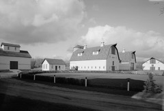 | Femco Farm No. 2 | building | 1980 | 80002184 |
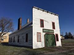 | J. A. Johnson Blacksmith Shop | building | 1996 | 96000174 |
| David N. Peet Farmstead | building | 1980 | 80002187 | |
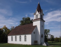 | Stiklestad United Lutheran Church | building | 1980 | 80002183 |
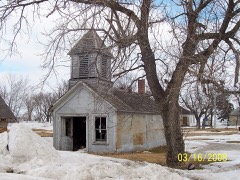 | Tenney Fire Hall | building | 1980 | 80002186 |
 | Wilkin County Courthouse | building | 1980 | 80002182 |
 | Wolverton Public School | building | 1980 | 80002188 |
Every wildfire the federal occurrence database records inside this county: 13 of them, burning about 5,099 acres. 1 started naturally and none was recorded as arson. Each settlement page carries the fires within five miles of it.
| Reported cause | Fires |
|---|---|
| Missing data/not specified/undetermined | 6 |
| Equipment and vehicle use | 3 |
| Debris and open burning | 2 |
| Natural | 1 |
| Recreation and ceremony | 1 |
The five largest, by the area the report gives. None of them was recorded as arson.
| Date | Cause | Size | Reported by | Name on the report |
|---|---|---|---|---|
| 7 October 2003 | Missing data/not specified/undetermined | 2,855 acres | Minnesota Department of Natural Resources | ROTHSAY |
| 1 May 1992 | Debris and open burning | 910 acres | Fergus Falls Wetland Management District | MEADOWS |
| 21 May 2012 | Equipment and vehicle use | 900 acres | Fergus Falls Wetland Management District | FFR DNR ASSIST |
| 28 April 2003 | Missing data/not specified/undetermined | 288 acres | Fergus Falls Wetland Management District | BROWN (SOUTH) |
| 6 May 1996 | Missing data/not specified/undetermined | 56 acres | Fergus Falls Wetland Management District | GERMUNDSON |
| 7 May 2018 | Equipment and vehicle use | 55 acres | Fergus Falls Wetland Management District | BELLMORE WF |
| 18 April 2015 | Missing data/not specified/undetermined | 21 acres | Fergus Falls Wetland Management District | HAUGRUD WF |
| 27 April 1998 | Recreation and ceremony | 5.0 acres | Fergus Falls Wetland Management District | WIRTH |
Every settlement page carries the fires within five miles of it - see the settlement index below.
The NOAA Storm Events Database holds 364 reports for this county, causing no deaths, 7 injuries and about $2,663,600 in recorded property damage. Each settlement page carries the reports that name it.
| Kind of event | Reports |
|---|---|
| Thunderstorm Wind | 136 |
| Hail | 126 |
| Tornado | 35 |
| Flash Flood | 35 |
| Flood | 15 |
| Funnel Cloud | 14 |
| Heavy Rain | 2 |
| Lightning | 1 |
The most serious of them, by death, then injury, then recorded damage. The accounts are quoted exactly as the forecast office filed them.
| When | Event | Place named | Harm | What the report says |
|---|---|---|---|---|
| June 1950 | Tornado (F2) | not stated | 4 hurt, $2,500 | no account filed |
| July 1955 | Tornado (F3) | not stated | 3 hurt, $250,000 | no account filed |
| April 2006 | Flood | Countywide | $552,000 | The Red River at Wahpeton/Breckenridge rose above flood stage around 2 AM CST on March 30th and remained above flood stage until around 8 PM CST on April 9th. The river peaked at roughly 15.95 feet around 3 AM CST on April 1st. Unofficially, 15.95 feet would be the sixth highest modern-day river stage recorded. Overland flooding also occurred in addition to the river flooding. Roughly 35 bridges and 35 roads around the county were closed due to flooding. A 6 mile stretch of Minnesota Highway 210 east of Breckenridge was covered with flowing water. U.S. Highway 75 was closed at the railroad underpass at Kent, while the Red River bridge from Kent to Abercrombie was also closed. The Minnesota Governor authorized the National Guard to assist in the flood fight, providing generators and support to the Wolverton area. After the spring flood of 1997, many communities along the Red River looked at ways to mitigate flood effects. For Breckenridge, a higher permanent levee system was in the process of being constructed. A majority of the dike work had been completed, but some stretches were still unfinished and needed temporary patches. A diversion was also constructed on the Otter Tail River at Breckenridge, which diverted floodwaters from the Otter Tail River north of the city and then back into the Red River. Wilkin County received a Presidential Disaster Declaration for damages caused by spring flooding.In summary, the total public and private flood losses experienced within the Red River of the North basin through late March and April 2006 were likely in excess of $20 million. This includes the following amounts. For Minnesota state and local infrastructure (this total includes the damages listed for each county), $8.5 million. For North Dakota state and local infrastructure (this total includes the damages listed for each county), $8 million. For Federal agencies (USACE, USGS, and USCG), $1.5 million. For the transportation industry costs due to traffic diversions caused by prolonged road and bridge closures, $1.5 million. For personal property losses due to floodwaters surrounding more than 500 individual farmsteads and rural homesteads, $1.0 million. |
| June 2017 | Thunderstorm Wind | Tenney | $500,000 | Several large grain bins were caved in by the strong wind and a couple of empty grain cars were blown over. |
| July 2010 | Thunderstorm Wind | Breckenridge | $250,000 | Numerous large trees were snapped or uprooted at various locations along a roughly 3 mile wide path centered along MN Highway 210. Farm machinery was moved about, doors and roofing materials were torn off farm buildings and homes. Peak winds estimated at 90 to 100 mph at multiple locations. |
| June 1979 | Tornado (F1) | not stated | $250,000 | no account filed |
| June 2008 | Tornado (EF1) | Foxhome | $150,000 | The tornado tracked for about two miles to around two miles north of Foxhome by 6 PM CDT. A machine shed was moved off its foundation. Several large trees were broken down or snapped off near the ground in local shelter belts. The peak winds were estimated at 95 mph with a maximum width of 50 yards. |
| July 2020 | Tornado (EF1) | Foxhome | $50,000 | This tornado began in Wilkin County, but ended in Otter Tail County, on the north side of Fergus Falls. The tornado was wrapped in downburst winds and rain, with a total track length of about 11 miles. The tornado uprooted or snapped numerous trees in shelterbelts along its path. It also snapped a few power poles and tore the roof off and collapsed the walls at a welding and manufacturing shop near the Fergus Falls airport. Peak winds were estimated at 100 mph. |
| July 2008 | Thunderstorm Wind | Campbell | $50,000 | A tool shed was blown down. Debris caused broken windows on the house. Several large trees were snapped off. |
| May 1998 | Thunderstorm Wind | Wolverton | $50,000 | 10 aluminum transmission structure were blown over by the strong wind. |
| March 2019 | Flood | Wolverton | $50,000 | no account filed |
| April 2019 | Flood | Wolverton | $50,000 | no account filed |
| May 1996 | Tornado (F1) | Campbell | $50,000 | no account filed |
| May 1996 | Thunderstorm Wind | Rothsay | $50,000 | no account filed |
| August 2008 | Flash Flood | Breckenridge | $40,000 | The city park was flooded and several streets were blocked off due to street flooding. |
| June 2002 | Tornado (F2) | Rothsay | $25,000 | A brief tornado touchdown demolished a 76x296 foot roof on a turkey barn. |
| July 2002 | Thunderstorm Wind | Campbell | $25,000 | A small aircraft hangar was blown down with the debris scattered over one-half mile away. |
| June 1986 | Tornado (F1) | not stated | $25,000 | no account filed |
| July 1977 | Tornado (F1) | not stated | $25,000 | no account filed |
| July 2011 | Thunderstorm Wind | Tenney | $20,000 | A few large trees were blown down at a farmstead. Wind damage continued intermittently through Tenney to Nashua, and across southern Campbell and Champion townships. |
| July 2008 | Hail | Campbell | $20,000 | The hail varied in size from penny to golfball. |
| August 2008 | Flash Flood | Kent | $20,000 | U.S. Highway 75 was flooded at the railroad underpass near Kent. |
| July 2002 | Thunderstorm Wind | Campbell | $20,000 | Widespread tree and roof damage was observed. Trees were uprooted and power lines were blown down. |
| April 2012 | Tornado (EF0) | Kent | $15,000 | This tornado touched down near a farmstead and then tracked intermittently to the east for about a half mile. The tornado tore all of the tin roofing and roof panels from an open faced pole shed. It also tore down several tree limbs in the farmyard and tossed a trampoline on top of the garage. Peak winds were estimated at 80 mph. |
| July 2002 | Thunderstorm Wind | Campbell | $15,000 | A garage was blown down. |
| June 2013 | Flood | Wolverton | $10,000 | Overland flooding developed over portions of Wolverton Township drained by Wolverton Creek. Six to ten inches of very heavy rainfall the preceding evening collected in farm fields, ditches, and smaller streams through the early morning then steadily drained towards Wolverton Creek and the Red River. Wolverton Creek overtopped and partially washed out rural township and county roads at several locations. |
| June 2009 | Flash Flood | Wolverton | $10,000 | Farm access roads and a 140 acre field were flooded. U.S. Highway 75 north of Kent was underwater and remained closed due to damage from earlier spring flooding. Portions of southern Roberts and northern McCauleyville townships along the Whiskey Creek drainage basin received 5 to 7 inches of rain from late afternoon into the late evening of the 16th. |
| July 2002 | Thunderstorm Wind | Tenney | $10,000 | A power pole was snapped and trees damaged. |
| July 2016 | Flash Flood | Breckenridge | $5,000 | Fields and farm access roads were flooded near the Doran Slough. |
| June 2013 | Flash Flood | Wolverton | $5,000 | Widespread flooding was reported in and around Wolverton. A total of 8.25 inches of rain was reported in town with over nine inches reported just outside of town to the south. |
| June 2013 | Flash Flood | Kent | $5,000 | Water was reported over U. S. Highway 75 near Kent. |
| July 2011 | Tornado (EF1) | Breckenridge | $5,000 | This tornado touched down in a farmstead shelterbelt just east of Lake Breckenridge and tracked near a second residence during its roughly one mile path. Some large trees were knocked down, a number of large branches were broken down and a few shingles were lifted off the house. A two cubic yard metal dumpster was lifted and thrown about 100 feet into a nearby ditch. Peak winds were estimated at 95 mph. |
| June 2009 | Flash Flood | Mc Cauleyville | $5,000 | Several fields and farm access roads were flooded in McCauleyville and Nordick townships. The U.S. Highway 75 bridge over Whiskey Creek closed with water running level with the bridge deck. The highway was also closed at the railroad bridge underpass due to long term flooding issues. |
| July 2008 | Thunderstorm Wind | Campbell | $5,000 | Several large trees were snapped off. |
| July 2008 | Thunderstorm Wind | Foxhome | $5,000 | Four inch diameter branches were blown down. |
| July 1999 | Thunderstorm Wind | Rothsay | $5,000 | A semi truck was overturned on Interstate 94. |
| June 2014 | Flash Flood | Breckenridge | $5,000 | no account filed |
| May 2012 | Flood | Rothsay | $5,000 | no account filed |
| June 2009 | Flood | Wolverton | $5,000 | no account filed |
| March 2009 | Flood | Wolverton | $5,000 | no account filed |
| April 2009 | Flood | Wolverton | $5,000 | no account filed |
| July 2008 | Hail | Kent | $5,000 | no account filed |
| May 1964 | Tornado (F3) | not stated | $2,500 | no account filed |
| August 2010 | Flash Flood | Nashua | $2,000 | Multiple heavy downpours of 3 to 4 inches of rain produced localized flooding of farm fields and farm access roads near the Rabbit River drainage. |
| September 2014 | Flash Flood | Wolverton | $1,000 | Several farm access roads and fields were flooded across Wolverton Township. |
| July 2010 | Flash Flood | Lawndale | $1,000 | Roughly 1.50 inches of rain fell in 15 minutes. |
| July 2001 | Thunderstorm Wind | Rothsay | $1,000 | Several large branches were blown down. |
| September 2014 | Flash Flood | Lawndale | $500 | Numerous fields and farm access roads were flooded across Atherton and Prairie View townships. |
| August 2000 | Thunderstorm Wind | Wolverton | $500 | Large branches were blown down. |
| July 2002 | Thunderstorm Wind | Tenney | $200 | Branches were blown down. |
| August 2002 | Thunderstorm Wind | Wolverton | $200 | Tree limbs were blown down. |
| May 1998 | Thunderstorm Wind | Kent | $200 | Several trees were downed by the strong wind. |
| August 2025 | Hail | Campbell | - | Hail was mostly pea size, with a few stones around quarter size. Time estimated by radar. |
| August 2025 | Thunderstorm Wind | Wolverton | - | Wind gust measured on NDAWN site Wolverton 2E. |
| June 2025 | Thunderstorm Wind | Wolverton | - | Measurement on 10 meter NDAWN sensor. |
| June 2025 | Thunderstorm Wind | Mc Cauleyville | - | RWIS measured gust north of Kent along US Highway 75. |
| June 2025 | Thunderstorm Wind | Foxhome | - | Ndawn measured gust at Foxhome. |
| June 2025 | Thunderstorm Wind | Mc Cauleyville | - | MN dot mesonet station MN135 Kent, MN. |
| June 2025 | Thunderstorm Wind | Rothsay | - | Measurement on 10 meter NDAWN sensor. |
| June 2024 | Thunderstorm Wind | Foxhome | - | Combination of quarter sized hail and strong winds striped and destroyed cornfields. Time estimated from Radar. |
The Survey's mineral resources record lists 5 workings inside this county. All of them still produce. Each settlement page carries the workings within five miles of it.
| Commodity | Workings |
|---|---|
| Sand and Gravel, Construction | 4 |
| Stone, Crushed/Broken | 1 |
The least common of them first, because a county's hundredth gravel pit says nothing its first ten did not.
| Where | Site | Commodity | Status | Recorded |
|---|---|---|---|---|
| Winona Quarry and Mill | Stone, Crushed/Broken | Producer | ||
| Foxhome Pit and Mill | Sand and Gravel, Construction | Producer | ||
| Kost Bros Pit | Sand and Gravel, Construction | Producer | ||
| Rasmussen Pit | Sand and Gravel, Construction | Producer | ||
| Turner Pitsd Mill | Sand and Gravel, Construction | Producer |
Named settlements recorded in the Geographic Names Information System, each with the topographic sheets covering it. Villages, hamlets and abandoned places alike. Each is shown with the nearest named watercourse or landform and the survey quadrangle it falls on.
Breckenridge city · 56520 · On Bois de Sioux River · Wahpeton quadrangle
11 sheets, 1904 to 1989
Campbell township · 56522 · On South Fork Rabbit River · Campbell quadrangle
8 sheets, 1951 to 1989
McCauleyville township · 56553 · On Whisky Creek · Abercrombie quadrangle
9 sheets, 1904 to 1989