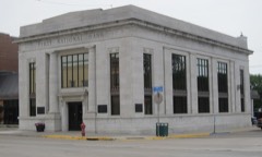
Listed on the National Register of Historic Places in 1980.
From the record
“In September, of this year, five energetic young men, then in St. Paul, moved by the spirit of the times and impelled much by the same motives which had actuated the founders of Blue Earth City, also conceived the idea of establishing a town somewhere in the great Territory of Minnesota.”
The History of Faribault County, Minnesota : from Its First Settlement to the Close of the Year 1879 : the Story of the Pioneers (1896). Machine-read text.
One of 11 National Register listings published here for Faribault County · listed in 1980 · category: Building.
Architectural style. Queen Anne style architecture in the United States, Neoclassical architecture
National Register reference number.80004265- the number the National Park Service assigned this property when it was listed, and the key its nomination file is catalogued under at the National Archives.
In September, of this year, five energetic young men, then in St. Paul, moved by the spirit of the times and impelled much by the same motives which had actuated the founders of Blue Earth City, also conceived the idea of establishing a town somewhere in the great Territory of Minnesota. Their names were Andrew C. Dunn, Warren N. Dunham. Elijah H. Barritt, James Sherlock and Charles H. Parker. Having determined on this project, they at once purchased a team and outfit, and all except Mr. Parker, started out to find an eligible location. They laid their course for Lake Albert Lea, in Freeborn county, adjoining this county on the east, and ar- rived there about the first of October. But on reaching that point they found that tlie only suitable location for a town had already been taken up by George Ruble and others. They endeavored to get an interest in this location, but failed. The question then arose to what point should they now direct their course? Mr. Dunn remembered having met, during the summer of this year, at Mankato, Grover C. Burt and Hiram L. Young, who were at the time living on the Blue Earth river, in this county, and who had given him very glowing descriptions of the Blue Earth Valley and strongly invited him to visit this region. So they started for the Blue Earth, where they safely arrived and made inquiry for Mr. Young, whom they found living in a tent on the lands of Capt. H. H. Bigelow, adjoining what is now the site of Winnebago City. Mr. Young and one B. K. Burt were then "claiming" the two quarter sections on which the village of Winnebago City was afterwards located, but on learning that our company were desirous of founding a city, they surrendered their claims and took others. Our company camped with Mr. Young about six weeks, while making the claim and locating the town. The town was located upon the south-east quarter of section thirty-four and the south-west quarter of section thirty-five in town one hundred and four of Range twenty-eight west.
A hotel building next demanded attention. One Dr. W. N. Towndrow, assisted by the town proprietors, undertook this important work. This structure was twenty by thirty-six feet and one and one-half stories high. The boards for the floor and roof - green basswood and elm - were purchased at Mankato, at an expense of about seventy-five dollars per thousand feet. The building, however, was not finished until the next year, but served a good purpose as a fort, during the Indian excitement, in the spring of 1857. A steam saw mill was also purchased in Chicago, by the company during the year, but did not arrive until the following spring. The further history of this young city will be found in the historical sketch of Winnebago City township.
Regional context, not property-specific
evidence. The
federal wildfire occurrence database
lists 2 fires within 5 miles of Andrew C. Dunn House
between 2000 and 2006, burning about 88 acres in total. None started naturally. None was recorded as arson.
Distance is straight-line from the map coordinates, so a fire counted
here may appear on a neighbouring settlement's page as well.
Reported cause
Fires
Missing data/not specified/undetermined
2
The most recent of
them, most recent first, with the day each was reported and the service
that recorded it.
Regional context, not property-specific
evidence. The federal mineral resources record lists
6 workings within 5 miles of Andrew C. Dunn House: 6 producers.
All of them still produce. What was taken out: Sand and Gravel, Construction, Clay. Distance is straight-line from the
map coordinates, so a quarry counted here may appear on a neighbouring
settlement's page as well.
Regional context, not property-specific
evidence. The National Weather Service names
Winnebago, the town this property stands in, in 26 storm reports between 1998 and 2019: 15 hail, 4 thunderstorm wind, 3 flood, 3 heavy rain.
No death or injury is recorded in these reports. Each account below is quoted exactly as the forecast office
filed it, from the NOAA Storm Events Database, and each date
opens the federal record of that event.
Strong thunderstorms dumped between two and two and one half inches of rainfall over western Faribault county in approximately 2 hours. Scattered streets were reported under water in Winnebago and over the surrounding area. Basement flooding occurred in Blue Earth.
No historic map-sheet match is published
for this property yet. That does not mean no map exists. This record needs
a coordinate-quality review before it can be joined to a sheet boundary.
Browse the county's mapped places while that work is
pending.
Listed places nearby
1 within 8 miles
Other National Register properties close
enough to walk or drive between, ordered by distance from this one. Both
positions come from the same geocoding pass that matched these properties
to their map sheets.
Listing record. National Park Service National Register of Historic Places, listed-properties dataset, current to 2026-05-22.
Map join. Address geocoded through the United States Census geocoder, then tested against the published boundary of every sheet in the USGS Historical Topographic Map Collection.
How this page is made. Listing fields come from federal records; map-sheet coverage is a labelled coordinate-to-boundary calculation, not a source-field claim.
Wildfire. Short, Karen C. 2022. Spatial wildfire occurrence data for the United States, 1992-2020 [FPA_FOD_20221014]. 6th Edition. Fort Collins, CO: Forest Service Research Data Archive. https://doi.org/10.2737/RDS-2013-0009.6 Collected with United States Government funding and usable without additional permissions or fees.
Mines and quarries. USGS Mineral Resources Data System (MRDS) https://mrdata.usgs.gov/mrds/ A work of the United States government, no copyright under 17 U.S.C. 105.
Storms. NOAA National Centers for Environmental Information, Storm Events Database https://www.ncei.noaa.gov/stormevents/ A work of the United States government, no copyright under 17 U.S.C. 105. Narratives are quoted verbatim from the National Weather Service report and are not edited or summarised.
 Block