BlockBefore

Faribault County, Minnesota

30 topographic sheets cover 19 settlements here, and 11 properties are on the National Register of Historic Places.

Research this county

From the record

“The people of this town, like all others residing on the frontiers, became greatly apprehensive of an attack by the Indians, at the time of the great massacre in 1862. They held a number of meetings, when plans of defense were discussed. A military company was formed, of which James Ogilvie was commissioned first lieutenant, and the company was drilled by Sergeant Shepard Young, the only old soldier in the company.”

Sundry Interesting Facts - The History of Faribault County, Minnesota : from Its First Settlement to the Close of the Year 1879 : the Story of the Pioneers (1896). Machine-read text.

11 National Register listings published here · the county-history sources tell 4 stories and name 29 people · people the book names include Sheridan J. Abbott (Kiester Township, 1896) · Hon. Smith T. Barnes (Minnesota Lake City, 1896) (machine-read).

Sources: the county history on the Internet Archive · the National Register database, National Park Service

Minnesota within the United States
Faribault County within Minnesota

What the record shows

  • 138 topographic sheet readings cover the county's settlements.
  • 11 properties here are on the National Register of Historic Places: 11 buildings.
  • 1 of the 11 listings was added during the 1970s.
  • The Geographic Names Information System records 19 populated places in this county; 19 are covered by at least one topographic sheet.
  • 1 public-domain county history, 1896, supplies 77,202 words of narrative reproduced here.

What happened here

4 accounts

Among them: In Early Days; Murder; Interesting Incidents. These passages come from the identified county-history source books. Each inset names its own source and opens the exact section it comes from.

From The History of Faribault County, Minnesota : from Its First Settlement to the Close of the Year 1879 : the Story of the Pioneers, published 1896 - Clark Township

In Early Days

"Three soldiers were frozen to death in a blizzard which swept over this part of the country during the winter of 1864, and their bodies were not found until spring. When found one was identified as the body of Mr. Daramas, of Minnesota Lake, and the others as the remains of two comrades named Price, who accompanied him to his home In this county on a furlough.

Read the rest of this passage

From The History of Faribault County, Minnesota : from Its First Settlement to the Close of the Year 1879 : the Story of the Pioneers, published 1896 - Delavan City

Murder

A murder was committed at Wells, on the 4th day of November. This was the fourth homicide in the county. The facts in the case, briefly stated, are about as follows. A number of Swedes and Norwegians under the influence of intoxicating liquors got into a street brawl when one Nels Hast stabbed or cut one Ole Olsen in the neck.

Read the rest of this passage

From The History of Faribault County, Minnesota : from Its First Settlement to the Close of the Year 1879 : the Story of the Pioneers, published 1896 - Verona Township

Interesting Incidents

At the time of the Ink-pe-du-ta massacre, in the spring of 1857, and again at the time of the Sioux massacre, in August, 1862, this town was almost completely depopulated, for a short time, and, although no attack was made on the people of the town, at either time, yet prudence dictated the abandonment of the town for the time be- ing.

Read the rest of this passage

From The History of Faribault County, Minnesota : from Its First Settlement to the Close of the Year 1879 : the Story of the Pioneers, published 1896 - Pilot Grove Township

Sundry Interesting Facts

The people of this town, like all others residing on the frontiers, became greatly apprehensive of an attack by the Indians, at the time of the great massacre in 1862. They held a number of meetings, when plans of defense were discussed. A military company was formed, of which James Ogilvie was commissioned first lieutenant, and the company was drilled by Sergeant Shepard Young, the only old soldier in the company.

Read the rest of this passage

Places on the National Register

11

Every property in this county listed on the National Register of Historic Places, with the year it was listed and the federal nomination document.

Photograph PropertyType ListedReference
Milwaukee Chicago St. Paul and Pacific Depot and Lunchroombuilding198080004263
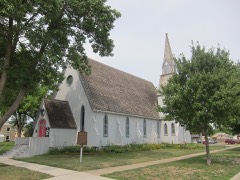
Church of the Good Shepherd-Episcopalbuilding198080004257
District No. 40 Schoolbuilding198080004264
Andrew C. Dunn Housebuilding198080004265
Faribault County Courthousebuilding197777000731
First National Bankbuilding198080004266
Peter Kremer Housebuilding198080004260
Muret N. Leland Housebuilding198080004261
Memorial Librarybuilding198888002835
James B. Wakefield Housebuilding198080004258
Walters Jailbuilding198080004262

Wildfire, 1999 to 2015

8 fires

Every wildfire the federal occurrence database records inside this county: 8 of them, burning about 122 acres. None started naturally and none was recorded as arson. Each settlement page carries the fires within five miles of it.

Reported cause Fires
Missing data/not specified/undetermined8

The five largest, by the area the report gives. None of them was recorded as arson.

DateCause SizeReported by Name on the report
9 November 2006Missing data/not specified/undetermined55 acresWindom Wetland Management DistrictPRESCOTT
13 October 2000Missing data/not specified/undetermined34 acresWindom Wetland Management DistrictPRESCOTT
19 April 2001Missing data/not specified/undetermined24 acresWindom Wetland Management DistrictPILOT GROVE
1 April 2003Missing data/not specified/undetermined4.0 acresWindom Wetland Management DistrictPILOT GROVE
17 October 2000Missing data/not specified/undetermined2.9 acresWindom Wetland Management DistrictPILOT GROVE
22 April 2015Missing data/not specified/undetermined1.0 acresWindom Wetland Management DistrictMINNESOTA LAKE
10 April 2000Missing data/not specified/undeterminedunder an acreWindom Wetland Management DistrictPILOT GROVE
8 October 1999Missing data/not specified/undeterminedunder an acreWindom Wetland Management DistrictSTRING LAKE

Every settlement page carries the fires within five miles of it - see the settlement index below.

Storms, 1957 to 2026

60 of 317 shown

The NOAA Storm Events Database holds 317 reports for this county, causing no deaths, 6 injuries and about $14,133,500 in recorded property damage. Each settlement page carries the reports that name it.

Kind of event Reports
Hail120
Thunderstorm Wind104
Tornado42
Flash Flood17
Heavy Rain14
Funnel Cloud12
Flood6
Lightning2

The most serious of them, by death, then injury, then recorded damage. The accounts are quoted exactly as the forecast office filed them.

WhenEvent Place namedHarm What the report says
June 1984Thunderstorm Windnot stated2 hurtno account filed
April 1967Tornado (F1)not stated2 hurtno account filed
September 2005HailMinnesota Lake1 hurtGolf ball sized hail fell in and around Minnesota Lake, west to County Road 17 N (460th Avenue), east to County Road 29 (570th Avenue), and south to 200th Street. Hail drifts and considerable corn and soybean crop damage were reported. One person walking from a shed to their house was bloodied by the hail.
June 1987Thunderstorm Windnot stated1 hurtno account filed
May 1998Thunderstorm WindElmore$10,000,00020 to 40 homes damaged. Estimated windspeed. Damage estimate for entire county.
May 1996Thunderstorm WindWells$1,500,000no account filed
September 2010FloodMinnesota Lake$402,000Numerous roads were closed due to excessive rainfall that fell on September 22nd and 23th.
September 2018Thunderstorm WindEaston$250,000A NWS storm survey concluded that a severe downburst caused significant structural damage in the town of Easton. A local church steeple was toppled, plus a few dozen trees were uprooted. Damage was consistent with winds up to 80-85 mph.
May 2012Tornado (EF0)Kiester$250,000The emergency manager of Faribault County survey damage associated with a tornado that touched down in the southeast part of the county on May 4th. ||The survey indicated that the tornado touchdown approximately 1.7 miles east of Kiester, and tracked east-northeast along County Road 2, and then turned northeast, to 2.4 miles northeast of Kiester before dissipating. The tornado was rated an EF0, with winds of 75 mph. It damaged trees, took down three barns, and destroyed a number of sheds and other outbuildings. In addition, a few windows were blown out, along with several power poles blown down.
March 1991Tornado (F1)not stated$250,000no account filed
June 1981Tornado (F2)not stated$250,000no account filed
May 1980Tornado (F1)not stated$250,000no account filed
June 1967Tornado (F1)not stated$250,000no account filed
June 2014FloodWinnebago$150,000Multiple local and county roads were closed and there were some impacts to wastewater treatment plants and drinking water systems.
June 2013Thunderstorm WindMinnesota Lake$100,000Several large trees blew down, which damaged three homes and a garage. Power lines were also blown down due to falling trees.
June 2013HailWells$100,000Baseball size hail caused damage to area roofs in Wells, Minnesota.
July 1997Tornado (F0)Blue Earth$100,0002 farmsteads damaged.
June 2010Thunderstorm WindMinnesota Lake$50,000Several power lines and trees were blown down near Minnesota Lake, Minnesota.
June 2013HailWells$25,000There was damage to roof shingles and siding of houses, with the hail depth of a few inches.
June 2013Thunderstorm WindWells$25,000A trained spotter, along with video coverage of the storm, had sustained severe winds lasting for 10 minutes or more. In addition to numerous trees blown down or uprooted, a barn north of Wells was destroyed.
June 2010Thunderstorm WindMinnesota Lake$25,000Hundreds of trees and some power poles were blown down in a two mile wide swath from southeast of Minnesota Lake to southeast of Wells. Several trees up to 3 feet in diameter were blown down across Highway 22. Sheds and other outbuildings were also damaged. Most of the damage in Wells was in the northern and eastern portions.
June 1990Tornado (F1)not stated$25,000no account filed
September 1985Tornado (F1)not stated$25,000no account filed
July 1978Tornado (F0)not stated$25,000no account filed
May 1959Tornado (F1)not stated$25,000no account filed
June 2001Thunderstorm WindWells$20,000Barn shifted off foundation. Several trees felled.
June 2013HailWells$15,000There was damage to trees and broken windshields north of Wells, Minnesota.
September 2018Thunderstorm WindGranada$5,000A NWS storm survey concluded that a severe downburst caused significant tree damage in the Riverside Town Country Club east of Granada.
June 2010Thunderstorm WindBlue Earth$5,000Several large tree branches were blown down, and caused a garage roof to be damaged in the city of Blue Earth, Minnesota.
April 2002Thunderstorm WindBlue Earth$5,000Tree down on car.
June 1964Tornado (F0)not stated$2,500no account filed
April 2016Thunderstorm WindBlue Earth$2,000Large tree branches were blown down, with a trailer tossed near Blue Earth.
June 2009Tornado (EF0)Easton$1,000A tree was downed and a garage door damaged from a brief tornado at a farmstead. Rear flank downdraft winds also caused tree damage about 150 yards north-northwest of the tornado.
June 2009Tornado (EF0)Walters$1,000Tornado moved through a corn field, occasionally touching down, then blew the lids off the top of two grain bins, crossed Highway 22, and dissipated in a corn field.
April 2026Tornado (EF1)Pilot Grove-This tornado track and timing are based on videos from two different storm chasers as well as damage reported by personnel with the Elmore Fire Department. The tornado mostly moved over open fields, but toward the end, it hit a farm, taking tin off a shed and blowing in garage doors. Trees were also broken. The maximum wind speed was estimated at 90 mph.
April 2025Thunderstorm WindBrush Creek-Thunderstorm winds forced power poles to lean and pull towards the ground. A farm outbuilding sustained some roof damage.
April 2025Thunderstorm WindMinnesota Lake-Photo of large pine tree blown over.
August 2025Funnel CloudDelavan-A trained spotter reported several brief funnel clouds with a storm just west of Delavan.
June 2025Tornado (EF0)Walters-A tornado was caught on video in Faribault County, just north of Interstate 90. It moved across fields before moving into Freeborn County, where it hit some trees. Satellite imagery confirmed the tornado path. Based on the tree damage, the maximum wind speed was estimated at 80 mph.
August 2024Tornado (EF0)Wells-The tornado mostly moved across fields, but it did hit one house. A storm chaser took video of the tornado. Satellite imagery showed a path through the crops, enabling a determination of the beginning and end points.
August 2024Thunderstorm WindWells-Several trees and very large branches were taken down in the southeast side of Wells due to a downburst not far from a tornado.
August 2024Flash FloodWells-Flooded roadways in the southwest part of Wells due to heavy rain.
June 2024Thunderstorm WindWalters-Several trees were knocked down or broken.
June 2024Heavy RainWells-A total of 3 to 5 inches of rain fell from multiple rounds of thunderstorms. CoCoRaHS observers measured 4.62 inches near Minnesota Lake.
December 2021Tornado (EF0)Kiester-A barn lost its roof. Large tree limbs were also downed. This tornado began in Winnebago County, Iowa (see entry from NWS Des Moines).
July 2019Thunderstorm WindWells-In the city of Wells, several large branches, and a tree were blown down in the city park.
August 2019Thunderstorm WindWinnebago-A few large tree limbs were blown down in Winnebago.
July 2019Thunderstorm WindWinnebago-A trained spotter reported a large tree limb blown down in the city of Winnebago.
July 2018HailHuntley-A swath of large hail, up to golf ball size, occurred near Truman, then southeast to west of Blue Earth. The local emergency management had reports of shredded crops due to the intense amount and wind associated with the hail.
July 2018HailHuntley-A swath of very large hail, up to baseball size, occurred from south of Huntley, southeast to south-southeast of Blue Earth. Crops were reported shredded in this area due to the extremely large hail and wind. The COOP observer in Blue Earth reported up to quarter size hail during this time period.
September 2018Tornado (EF0)Huntley-This is the continuation of the Martin County tornado that continued into Faribault County before dissipating in a field approximately 1.2 miles east of the county line. Most of the damage was associated with downed trees and power lines. Maximum width was 70 yards with an EF0 rating based on damage.
May 2018Tornado (EF0)Minnesota Lake-A landspout tornado moved across an open field and was filmed on video. It did not hit anything.
March 2017HailFrost-A swath of large hail, up to ping pong size, fell along the Iowa, Minnesota border south of Frost, northeast to north of Bricelyn.
March 2017Tornado (EF1)Bricelyn-A NWS storm survey indicated that a EF1 tornado touched down just northwest of Bricelyn, and moved northeast, damaging a campground at Rice Lake, then it moved just north of I-90 before lifting. Several camper trailers were overturned or lofted, numerous trees were uprooted or broken, several sheds were damaged, and one barn collapsed.
September 2016Heavy RainFrost-A local trained weather observer measured 5.10 inches of rainfall near Frost between Wednesday afternoon, September 21st, to the early morning of Thursday, September 22nd.
September 2016Heavy RainWells-A local trained weather observer measured 5.15 inches of rainfall near Wells between Wednesday afternoon, September 21st, to the early morning of Thursday, September 22nd.
September 2015Flash FloodWells-Several streets were flooded in the town of Wells.
June 2014Heavy RainWinnebago-A 48 hour rainfall total of 6.50 inches was reported.
June 2014Heavy RainWells-A measured 12 hour rainfall total of 2.57 inches near Wells.
June 2014Thunderstorm WindEaston-A large shed roof was blown off.

Mines and quarries

10 recorded

The Survey's mineral resources record lists 10 workings inside this county. All of them still produce. Each settlement page carries the workings within five miles of it.

Commodity Workings
Sand and Gravel, Construction8
Clay2

The least common of them first, because a county's hundredth gravel pit says nothing its first ten did not.

Where SiteCommodity StatusRecorded
Faribault County PitsClayProducer
Baker Pit & MillSand and Gravel, ConstructionProducer
Hodgman MillSand and Gravel, ConstructionProducer
Hodgman PitSand and Gravel, ConstructionProducer
Hodgman Pit & MillSand and Gravel, ConstructionProducer
Kluender Pit & MillSand and Gravel, ConstructionProducer
Olman Pit & MillSand and Gravel, ConstructionProducer
W Hodgman & Sons PitSand and Gravel, ConstructionProducer

The townships, in 1896

77,202 words

The History of Faribault County, Minnesota : from Its First Settlement to the Close of the Year 1879 : the Story of the Pioneers devotes a chapter to each township: its boundaries and streams, who settled it and when, the mills, the schools and the churches. All 15 are reproduced here in full. Each row shows the township's own shape and where it lies in the county, drawn from the Census Bureau's boundary. Which settlements belong to which township is computed from that same boundary, not taken from the book.

Shape and position in the county TownshipSettlements in it LengthSections
Blue Earth CityBlue Earth, Riverside Heights6,978 words16
Brush Creek TownshipBrush Creek964 words7
Clark TownshipBaroda, Wells3,827 words7
Delavan CityDelavan12,180 words29
Easton CityEaston2,466 words5
Elmore CityElmore3,182 words16
Emerald TownshipDell, Marna3,610 words4
Foster TownshipWalters1,434 words8
Jo Daviess TownshipGuckeen1,613 words8
Kiester TownshipKiester30,544 words42
Minnesota Lake CityMinnesota Lake1,065 words3
Pilot Grove TownshipPilot Grove2,903 words11
Seely TownshipBricelyn1,330 words7
Verona TownshipHuntley2,593 words10
Winnebago CityWinnebago2,513 words5

The county's history books

186,526 words

One book written about this county, cut here where the book itself is cut, at its printed chapters: 26 chapters in all. Every chapter is public domain, machine-read from the scan and reproduced complete. A chapter already given under one of the county's towns is not repeated in this list.

The History of Faribault County, Minnesota : from Its First Settlement to the Close of the Year 1879 : the Story of the Pioneers (1896)

ChapterLength
Chapter 17,628 words
Chapter 28,555 words
Chapter 315,187 words
Chapter 55,549 words
Chapter 64,221 words
Chapter 79,854 words
Chapter 86,859 words
Chapter 96,857 words
Chapter 1014,526 words
Chapter 126,210 words
Chapter 133,666 words
Chapter 146,619 words
Chapter 158,865 words
Chapter 178,427 words
Chapter 1814,875 words
Chapter 207,728 words
Chapter 216,706 words
Chapter with an unread heading (no. 19 of those read)9,236 words
Chapter with an unread heading (no. 20 of those read)12,130 words
Chapter with an unread heading (no. 21 of those read)11,684 words
Chapter 1: Dunbar Township1,597 words
Chapter 2: Minnesota Lake Township2,947 words
Chapter 3: Lura Township - Easton1,574 words
Chapter 7: Prescott Township1,904 words
Chapter 8: 15arber Township1,461 words
Chapter 18: Rome Township1,661 words

The people it describes

29 named

Everyone The History of Faribault County, Minnesota : from Its First Settlement to the Close of the Year 1879 : the Story of the Pioneers stops to write about, with the section that describes them. Among them are the men who founded the place and governed the Territory. Each name opens the passage itself, in the words of 1896.

Every populated place in the county

19

Named settlements recorded in the Geographic Names Information System, each with the topographic sheets covering it. Villages, hamlets and abandoned places alike. Each is shown with the nearest named watercourse or landform and the survey quadrangle it falls on.

Provenance

  • Topographic sheets. USGS Historical Topographic Map Collection, county index, measured from the bulk metadata.
  • Fire insurance maps. Library of Congress Sanborn collection, faceted to this county.
  • Photographs. Each place queried individually against the Library of Congress Prints and Photographs search.
  • Wildfire. Short, Karen C. 2022. Spatial wildfire occurrence data for the United States, 1992-2020 [FPA_FOD_20221014]. 6th Edition. Fort Collins, CO: Forest Service Research Data Archive. https://doi.org/10.2737/RDS-2013-0009.6 Collected with United States Government funding and usable without additional permissions or fees.
  • Mines and quarries. USGS Mineral Resources Data System (MRDS) https://mrdata.usgs.gov/mrds/ A work of the United States government, no copyright under 17 U.S.C. 105.
  • Storms. NOAA National Centers for Environmental Information, Storm Events Database https://www.ncei.noaa.gov/stormevents/ A work of the United States government, no copyright under 17 U.S.C. 105. Narratives are quoted verbatim from the National Weather Service report and are not edited or summarised.