 Block
From the record
One of 76 National Register listings published here for Rice County · listed in 1982 · category: Building.
Sources: the case file at the National Archives · the National Register database, National Park Service

Listed on the National Register of Historic Places in 1982.
One of 76 National Register listings published here for Rice County · listed in 1982 · category: Building.
Sources: the case file at the National Archives · the National Register database, National Park Service
Regional context, not property-specific evidence. The federal wildfire occurrence database lists 6 fires within 5 miles of Wiliam Martin House between 2001 and 2012, burning about 6 acres in total. None started naturally. None was recorded as arson. Distance is straight-line from the map coordinates, so a fire counted here may appear on a neighbouring settlement's page as well.
| Reported cause | Fires |
|---|---|
| Recreation and ceremony | 3 |
| Equipment and vehicle use | 2 |
| Missing data/not specified/undetermined | 1 |
The most recent of them, most recent first, with the day each was reported and the service that recorded it.
| Date | Cause | Size | Reported by | Name on the report |
|---|---|---|---|---|
| 1 May 2001 | Missing data/not specified/undetermined | 2.0 acres | Minnesota Valley National Wildlife Refuge | STOLAF |
| 20 April 2012 | Recreation and ceremony | under an acre | Minnesota Valley National Wildlife Refuge | BLACK DOG |
| 7 December 2012 | Recreation and ceremony | under an acre | Minnesota Valley National Wildlife Refuge | BLOOMINGOTN FERRY 1 |
| 29 November 2012 | Recreation and ceremony | under an acre | Minnesota Valley National Wildlife Refuge | SORENSON LANDING 1 |
| 22 October 2012 | Equipment and vehicle use | 1.0 acres | Minnesota Valley National Wildlife Refuge | CO RD 18 |
| 12 October 2012 | Equipment and vehicle use | 3.0 acres | Minnesota Valley National Wildlife Refuge | CO RD 101 |
Regional context, not property-specific evidence. The federal mineral resources record lists 1 working within 5 miles of Wiliam Martin House: 1 producer. All of them still produce. What was taken out: Sand and Gravel, Construction. Distance is straight-line from the map coordinates, so a quarry counted here may appear on a neighbouring settlement's page as well.
| Where | Site | Commodity | Status | Recorded |
|---|---|---|---|---|
| Shilling Pit | Sand and Gravel, Construction | Producer |
Regional context, not property-specific evidence. The National Weather Service names Dundas, the town this property stands in, in 23 storm reports between 1998 and 2023: 12 hail, 9 thunderstorm wind, 2 tornado. No death or injury is recorded in these reports. Each account below is quoted exactly as the forecast office filed it, from the NOAA Storm Events Database, and each date opens the federal record of that event.
| When | Event | Place named | Harm | What the report says |
|---|---|---|---|---|
| August 2002 | Thunderstorm Wind | Dundas | $150,000 | Roof off house, three barns down, roofs off three storage buildings, one storage building blown 1/4 mile, garage collapsed, several hundred trees downed. A 56 knot gust was measured in downtown Northfield at the Public Safety Building, with 40 to 50 knot winds persisting for another 10 minutes. Wind was stronger just outside Northfield, where stronger wind and the most severe damage occurred. |
| March 2012 | Thunderstorm Wind | Dundas | $15,000 | A 50 foot tree was blown down and landed on an automobile in Dundas, Minnesota. |
| April 2022 | Hail | Dundas | - | There was a swath of large hail, up to ping pong size, that fell from near Dundas, northeast across the city of Northfield, and to the Dakota, Rice County line. |
| May 2021 | Tornado (EF0) | Dundas | - | Two storm chasers took video of a narrow tornado. A damage survey revealed that several trees were broken or blown down. Law enforcement and spotters were also watching the tornado. |
| September 2018 | Thunderstorm Wind | Dundas | - | A NWS storm survey, plus areal footage of drone and satellite data, concluded that there was sporadic downburst and inflow wind damage from south of Northfield, east and northeast to the Rice, Goodhue county line, west of Stanton. ||There was no definite path of damage but more widespread uprooted trees, power lines, and destroyed outbuildings and silos. The worst damage occurred to a farm near the intersection of 90th Street East, and Kellogg Ave. Two large silos and outbuildings were either blown over, or destroyed. The damage is consistent with wind gusts of 110 mph. Other damage was associated with flattened corn and soy bean fields. |
| September 2018 | Tornado (EF0) | Dundas | - | A NWS storm survey, plus areal footage of drone and satellite data, concluded that an EF0 tornado tracked 5.5 miles from the intersection of I-35 and 130th Street West, northeast to the city of Dundas. This tornado started with damage to a billboard on I-35 with uprooted pine trees, then mainly damage to corn and soy bean fields, and it ended with several large trees uprooted in Dundas. The damage was consistent with EF0 damage with maximum wind speeds of 75 mph and a width of 75 yards. |
| June 2016 | Thunderstorm Wind | Dundas | - | A few trees were reported blown down in the area of 145th & 150th just west of Hwy 3. There was also a large pine tree (about 2' diameter) that fell partially onto I-35, north of 130th Street. There were also some trees down in the City of Northfield. |
| August 2012 | Thunderstorm Wind | Dundas | - | A large tree was uprooted east of Dundas. |
| July 2011 | Thunderstorm Wind | Dundas | - | A two foot diameter tree was blown down near Dundas, Minnesota. |
| July 2011 | Thunderstorm Wind | Dundas | - | Several large tree limbs were torn off a tree near Dundas, Minnesota. |
| June 1998 | Thunderstorm Wind | Dundas | - | Barn blown down along Co Rd 1. Estimated windspeed. |
| July 1998 | Thunderstorm Wind | Dundas | - | Power lines blown down. Estimated windspeed. |
| July 2023 | Hail | Dundas | - | no account filed |
| May 2017 | Hail | Dundas | - | no account filed |
| June 2012 | Hail | Dundas | - | no account filed |
| June 2012 | Hail | Dundas | - | no account filed |
| April 2006 | Hail | Dundas | - | no account filed |
| August 2006 | Hail | Dundas | - | no account filed |
| April 2004 | Hail | Dundas | - | no account filed |
| May 2004 | Hail | Dundas | - | no account filed |
| June 1998 | Hail | Dundas | - | no account filed |
| June 1998 | Hail | Dundas | - | no account filed |
| June 1998 | Hail | Dundas | - | no account filed |
No historic map-sheet match is published for this property yet. That does not mean no map exists. This record needs a coordinate-quality review before it can be joined to a sheet boundary. Browse the county's mapped places while that work is pending.
Other National Register properties close enough to walk or drive between, ordered by distance from this one. Both positions come from the same geocoding pass that matched these properties to their map sheets.
| Photograph | Property | Distance | Listed |
|---|---|---|---|
 | Ault Store | under 500 feet | 1982 |
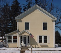 | Edward T. Archibald House | 0.1 miles | 1976 |
 | Church of the Holy Cross-Episcopal | 0.2 miles | 1982 |
 | Archibald Mill | 0.2 miles | 1976 |
 | Edwin S. Drake Farmhouse | 2.1 miles | 1982 |
 | Steensland Library-St. Olaf College | 2.5 miles | 1982 |
| National Archives record | The nomination case file for reference 82003006 in Record Group 79. |
| Rice County | All 76 listed properties in this county. |