
BlockBefore
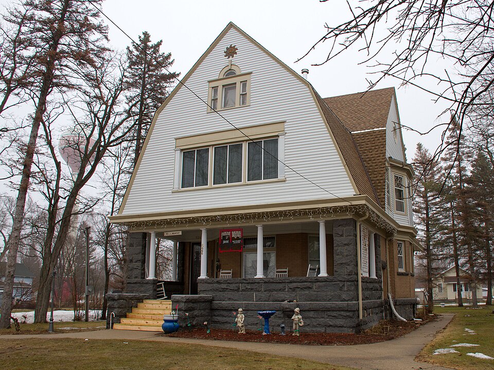
Photograph of Christopher Borgerding House
Photograph by Bobak Ha'Eri, CC BY 3.0. Via Wikimedia Commons.

Christopher Borgerding House

Built in 1904 (Colonial Revival architecture). Listed on the National Register of Historic Places in 1982.

From the record

“The Christopher Borgerding House is a historic house in Belgrade, Minnesota, United States. It was built from 1904 to 1905 for an early settler of Belgrade who became a successful businessman and platted an expansion to the town.”

Wikipedia article Christopher Borgerding House, CC BY-SA 4.0.

One of 36 National Register listings published here for Stearns County · listed in 1982 · category: Building · built in 1904, Colonial Revival architecture.

Sources: the Wikipedia article · the case file at the National Archives · the National Register database, National Park Service

The listing

  • What is counted as historic. The nomination lists 2 buildingss as contributing to the listing.
  • Listed as. Borgerding, Christopher, House - the National Register files a house under its owner's surname.
  • Address. Washburn Ave., Belgrade, 56312
  • When was it listed? April 1982
  • Category. building
  • Also known as. Stearns County MRA
  • City. Belgrade city
  • When was it built? 1904
  • Architectural style. Colonial Revival architecture
  • National Register reference number. 82003039 - the number the National Park Service assigned this property when it was listed, and the key its nomination file is catalogued under at the National Archives.

The ground it stands on

125 words

The chapter on Belgrade City in History of Stearns County, Minnesota, published 1915 names Belgrade. This is what it says, exactly as the scans read.

The Belgrade Tribune, published by W. P. Lemmer, is the representative of the southwestern section of the county. It is in its nineteenth year, according to the volume number, but the writer has been unable to obtain any information regarding its history. The Tribune of today is a well-edited and enterprising paper.

Passage source: History of Stearns County, Minnesota, published 1915.

Machine-read from a century-old scan, so expect the errors a machine makes: misspelled names, dropped words, stray characters.

Read the whole chapter on Belgrade City - 125 words on its settlement, mills, schools and churches.

Fires near this property

4 since 2000

Regional context, not property-specific evidence. The federal wildfire occurrence database lists 4 fires within 5 miles of Christopher Borgerding House between 2000 and 2006, burning about 190 acres in total. None started naturally. 2 were recorded as arson. Distance is straight-line from the map coordinates, so a fire counted here may appear on a neighbouring settlement's page as well.

Reported cause Fires
Arson/incendiarism2
Missing data/not specified/undetermined2

The most recent of them, most recent first, with the day each was reported and the service that recorded it.

DateCause SizeReported by Name on the report
16 April 2006Arson/incendiarism30 acresMinnesota Department of Natural Resourcesnot named
14 April 2000Arson/incendiarism10 acresMinnesota Department of Natural Resourcesnot named
11 October 2000Missing data/not specified/undetermined150 acresMinnesota Department of Natural Resourcesnot named
1 January 2001Missing data/not specified/undeterminedunder an acreMinnesota Department of Natural Resourcesnot named

Every fire recorded in Stearns County

Mines and quarries near this property

1 within 5 miles

Regional context, not property-specific evidence. The federal mineral resources record lists 1 working within 5 miles of Christopher Borgerding House: 1 producer. All of them still produce. What was taken out: Sand and Gravel, Construction. Distance is straight-line from the map coordinates, so a quarry counted here may appear on a neighbouring settlement's page as well.

Where SiteCommodity StatusRecorded
Olson PitSand and Gravel, ConstructionProducer

Every working recorded in Stearns County

Storms near this property

28 since 1998

Regional context, not property-specific evidence. The National Weather Service names Belgrade, the town this property stands in, in 28 storm reports between 1998 and 2023: 12 hail, 11 thunderstorm wind, 3 tornado, 1 funnel cloud. No death or injury is recorded in these reports. Each account below is quoted exactly as the forecast office filed it, from the NOAA Storm Events Database, and each date opens the federal record of that event.

WhenEvent Place namedHarm What the report says
July 2023Thunderstorm WindBelgrade-Fire department reported winds near 70 mph.
July 2023Thunderstorm WindBelgrade-There was a delayed report that a tarp was needed to cover a damaged roof on a local nursing home.
July 2023HailBelgrade-The hail size was based on a picture on social media.
May 2022Thunderstorm WindBelgrade-Several trees were blown down near Belgrade.
August 2021Tornado (EF0)Belgrade-Several storm chasers documented a tornado that started in Belgrade. It knocked over several trees and numerous large branches in town, and took a few shingles and some soffit off a house. It then moved north-northeast out of town, across open fields, and dissipated.
September 2017Tornado (EF0)Belgrade-A tornado knocked down several dozen trees, with some landing on cars and sheds. One tree landed on a mobile home. The tornado also destroyed a storage building (the building had been moved from another location and was still in the process of being made ready for business when the tornado came and blew it across the road).
September 2017Thunderstorm WindBelgrade-Dozens and possibly more than 100 trees were felled in Belgrade, just to the south of a tornado. A storm survey determined this was due to rear flank downdraft winds associated with the Belgrade tornado.
September 2017Thunderstorm WindBelgrade-A few dozen trees were damaged, the roof of an open sided shed was blown off, and several corn fields were damaged. This area may have been an earlier beginning point of the Belgrade tornado, but damage was too scant to be certain, and therefore this damage has been listed as thunderstorm wind damage.
July 2016Heavy RainBelgrade-A trained spotter measured 4.00 inches of rainfall near Belgrade.
June 2013Thunderstorm WindBelgrade-Several one to three foot diameter trees were blown down, and some damaged area power lines.
May 2012Thunderstorm WindBelgrade-Several large trees were blown down from north of Belgrade, to Elrosa, Minnesota.
May 2008HailBelgrade-Hail reported at Stearns and Kandiyohi County line along Highway 71 and County Road 198.
August 2007Thunderstorm WindBelgrade-Six to eight inch diameter tree limbs severed.
June 2007Thunderstorm WindBelgrade-Measured by MNDOT sensor along Highway 55.
June 2005Funnel CloudBelgrade-Law enforcement reported a funnel cloud at the intersection of county roads 4 and 59.
July 2003Thunderstorm WindBelgrade-Numerous trees down in Belgrade. Gust measured by MNDOT Road Weather System 3 ESE Belgrade; observation indicated the severe wind lasted 10 minutes.
July 2002HailBelgrade-Ground turned white.
June 2001Thunderstorm WindBelgrade-Trees and power lines toppled.
August 1999Tornado (F1)Belgrade-Roof partially off small cafe. Siding peeled off and lumber tossed around a lumber yard. Large steel tank blown off trailer.
July 2023HailBelgrade-no account filed
September 2019HailBelgrade-no account filed
June 2010HailBelgrade-no account filed
July 2010HailBelgrade-no account filed
July 2008HailBelgrade-no account filed
August 2007HailBelgrade-no account filed
September 1999HailBelgrade-no account filed
May 1998HailBelgrade-no account filed

Every storm recorded in Stearns County

Map coverage status

No historic map-sheet match is published for this property yet. That does not mean no map exists. This record needs a coordinate-quality review before it can be joined to a sheet boundary. Browse the county's mapped places while that work is pending.

Sources for this property

National Archives recordThe nomination case file for reference 82003039 in Record Group 79.
Wikipedia articleCommunity-written account of this property, licensed CC BY-SA.
Stearns CountyAll 36 listed properties in this county.

Provenance

  • Listing record. National Park Service National Register of Historic Places, listed-properties dataset, current to 2026-05-22.
  • Map join. Address geocoded through the United States Census geocoder, then tested against the published boundary of every sheet in the USGS Historical Topographic Map Collection.
  • How this page is made. Listing fields come from federal records; map-sheet coverage is a labelled coordinate-to-boundary calculation, not a source-field claim.
  • Wildfire. Short, Karen C. 2022. Spatial wildfire occurrence data for the United States, 1992-2020 [FPA_FOD_20221014]. 6th Edition. Fort Collins, CO: Forest Service Research Data Archive. https://doi.org/10.2737/RDS-2013-0009.6 Collected with United States Government funding and usable without additional permissions or fees.
  • Mines and quarries. USGS Mineral Resources Data System (MRDS) https://mrdata.usgs.gov/mrds/ A work of the United States government, no copyright under 17 U.S.C. 105.
  • Storms. NOAA National Centers for Environmental Information, Storm Events Database https://www.ncei.noaa.gov/stormevents/ A work of the United States government, no copyright under 17 U.S.C. 105. Narratives are quoted verbatim from the National Weather Service report and are not edited or summarised.