National Register reference number.82003047- the number the National Park Service assigned this property when it was listed, and the key its nomination file is catalogued under at the National Archives.
The ground it stands on
5,495 words
The chapter on Sauk Centre Township in History of Stearns County, Minnesota, published 1915 names Sauk Centre. This is what it says, exactly as the scans read.
The white man who first set his foot on the spot where now rises the beautiful little city of Sauk Centre was probably a reckless adventurer inspired by wanderlust. He passed on, leaving never a trace l>ehind him, and has now ended his aimless journeyings through the world. To this nomadic class belong not the real pioneers of a country, they who build its civilization. With these latter it is a desire for the erection of homes that sends them forth to endure all the hardships and perils of a new and uninhabited country. The love of home is instinctive with them:
The first settlement made in Sauk Centre was in the year 1856. It consisted of what was known as the "Sauk Centre -Townsite Co.," comprised of seven persons, of whom the leading spirit in the enterprise was Alexander Moore, who was then acting as agent for his mother, Rachel Moore. His arrival in this locality was probably antedated by that of W. R. James, the latter, however, after a short stay had departed to return a few years later. Although the township had not then been sub-divided, the outlines of a townsite were staked out.
Regional context, not property-specific
evidence. The
federal wildfire occurrence database
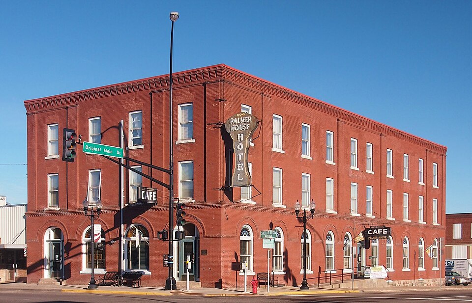
lists 4 fires within 5 miles of Palmer House Hotel
between 2000 and 2011, burning about 23 acres in total. None started naturally. 1 was recorded as arson.
Distance is straight-line from the map coordinates, so a fire counted
here may appear on a neighbouring settlement's page as well.
Reported cause
Fires
Recreation and ceremony
2
Debris and open burning
1
Arson/incendiarism
1
The most recent of
them, most recent first, with the day each was reported and the service
that recorded it.
Regional context, not property-specific
evidence. The federal mineral resources record lists
1 working within 5 miles of Palmer House Hotel: 1 producer.
All of them still produce. What was taken out: Sand and Gravel, Construction. Distance is straight-line from the
map coordinates, so a quarry counted here may appear on a neighbouring
settlement's page as well.
Regional context, not property-specific
evidence. The National Weather Service names
Sauk Centre, the town this property stands in, in 45 storm reports between 1993 and 2025: 23 hail, 13 thunderstorm wind, 3 flash flood, 2 tornado.
The reports record 1 injury. Each account below is quoted exactly as the forecast office
filed it, from the NOAA Storm Events Database, and each date
opens the federal record of that event.
The Sauk Centre City Officials noted that power was lost in the town at 1908 CST, which is when emergency sirens lost power. Several residents noted that the strong straight line winds lasted for 10 minutes. ||Damage occurred to approximately 200 trees in Sauk Centre which were either uprooted or snapped off with the line of storms. Tree damage was noted from Interstate 94, in the south, to the Sauk Centre Country Club to the north. ||The survey noted that all of the trees were laying toward the east, which was indicative of damage caused by straight line winds. Dozens of structures were also damaged in the town, though almost all of the structural damage was caused by falling trees. There was a toppled truck trailer, just over a dozen downed utility poles, and several snapped road signs.
Video on social media showed a tornado moving across the southern part of Sauk Lake. A damage survey found over a dozen trees uprooted or broken in the northwest wide of Sauk Centre, just east and southeast of the Old Golf Course. After moving across the lake, it knocked down a few more trees and dissipated.
There were numerous reports of county roads flooding between Sauk Centre and Melrose, including County Road 4 near the Sauk River, Highway 71 south of Sauk Centre, plus County Roads, 29, 186 and 169. These roads were closed during the height of the storm, and sustained damage due to debris and some erosion from the fast flowing water.
Very heavy rainfall began across Stearns County after 1200 AM CST, Friday, June 21st. Due to the extreme rainfall rates that continued through 130 AM CST, Friday, June 21st, several roads in the city of Sauk Centre became inundated with flood waters. The heavy rainfall tapered off after 2 AM CST, June 21st, and flood waters slowly receded during the early morning hours.
Semi-trailer trucks blown over on Interstate 94. Roof off two buildings at car dealership, garage door blown out, softball bleacher tossed, large trees uprooted, silo collapsed onto barn.
No historic map-sheet match is published
for this property yet. That does not mean no map exists. This record needs
a coordinate-quality review before it can be joined to a sheet boundary.
Browse the county's mapped places while that work is
pending.
Listed places nearby
3 within 8 miles
Other National Register properties close
enough to walk or drive between, ordered by distance from this one. Both
positions come from the same geocoding pass that matched these properties
to their map sheets.
Listing record. National Park Service National Register of Historic Places, listed-properties dataset, current to 2026-05-22.
Map join. Address geocoded through the United States Census geocoder, then tested against the published boundary of every sheet in the USGS Historical Topographic Map Collection.
How this page is made. Listing fields come from federal records; map-sheet coverage is a labelled coordinate-to-boundary calculation, not a source-field claim.
Wildfire. Short, Karen C. 2022. Spatial wildfire occurrence data for the United States, 1992-2020 [FPA_FOD_20221014]. 6th Edition. Fort Collins, CO: Forest Service Research Data Archive. https://doi.org/10.2737/RDS-2013-0009.6 Collected with United States Government funding and usable without additional permissions or fees.
Mines and quarries. USGS Mineral Resources Data System (MRDS) https://mrdata.usgs.gov/mrds/ A work of the United States government, no copyright under 17 U.S.C. 105.
Storms. NOAA National Centers for Environmental Information, Storm Events Database https://www.ncei.noaa.gov/stormevents/ A work of the United States government, no copyright under 17 U.S.C. 105. Narratives are quoted verbatim from the National Weather Service report and are not edited or summarised.
 Block