 Block
From the record
One of 28 National Register listings published here for Le Sueur County · listed in 1982 · category: Building.
Sources: the case file at the National Archives · the National Register database, National Park Service
Listed on the National Register of Historic Places in 1982.
One of 28 National Register listings published here for Le Sueur County · listed in 1982 · category: Building.
Sources: the case file at the National Archives · the National Register database, National Park Service
Regional context, not property-specific evidence. The federal wildfire occurrence database lists 3 fires within 5 miles of Union Hotel between 2003 and 2006, burning about 2 acres in total. None started naturally. 1 was recorded as arson. Distance is straight-line from the map coordinates, so a fire counted here may appear on a neighbouring settlement's page as well.
| Reported cause | Fires |
|---|---|
| Arson/incendiarism | 1 |
| Missing data/not specified/undetermined | 1 |
| Smoking | 1 |
The most recent of them, most recent first, with the day each was reported and the service that recorded it.
| Date | Cause | Size | Reported by | Name on the report |
|---|---|---|---|---|
| 10 April 2003 | Smoking | 2.0 acres | Minnesota Department of Natural Resources | not named |
| 9 November 2006 | Arson/incendiarism | under an acre | Minnesota Department of Natural Resources | not named |
| 20 October 2003 | Missing data/not specified/undetermined | under an acre | Minnesota Department of Natural Resources | not named |
Regional context, not property-specific evidence. The National Weather Service names Waterville, the town this property stands in, in 20 storm reports between 1999 and 2023: 8 hail, 5 thunderstorm wind, 4 tornado, 2 funnel cloud. The reports record 1 injury. Each account below is quoted exactly as the forecast office filed it, from the NOAA Storm Events Database, and each date opens the federal record of that event.
| When | Event | Place named | Harm | What the report says |
|---|---|---|---|---|
| June 2005 | Thunderstorm Wind | Waterville | 1 hurt | Trees were downed across the city. The roof of a trailer home and an attached garage was ripped off and a picture window was blown out. A man in the trailer home was cut on the leg by flying glass from a shattered window and required 14 stitches. A camper in the back yard of the home was blown into Whitewater Creek along with roof and tree debris. Damage was reported to other houses in the vicinity, including one home that was impaled by a 2x4 that came from a damaged building across the street. A tree was downed onto a power truck on Highway 60. |
| July 2021 | Thunderstorm Wind | Waterville | $10,000 | A few trees were blown over, along with approximately 20 feet of corn flattened on the north side of Lake Tetonka. |
| July 2017 | Thunderstorm Wind | Waterville | $10,000 | There were reports of trees and power lines blown down in Waterville. One house in Waterville lost its roof due to the severe winds. |
| June 2016 | Thunderstorm Wind | Waterville | $2,000 | A home had siding damage in Waterville. Numerous trees were also blown downed across the city, some were blocking city streets. |
| July 2020 | Heavy Rain | Waterville | - | A measured rainfall report over the last 24-hours at Waterville was 7.33 inches. |
| September 2018 | Tornado (EF1) | Waterville | - | This is a continuation path of the tornado that crossed the Waseca, Le Sueur county line southwest of Waterville. ||A NWS storm survey, plus areal footage of drone and satellite data, concluded that an EF1 tornado tracked an additional 5.8 miles from southwest of Waterville, then through the northwest corner of Waterville, or between Lake Tetonka and Upper Sakatah Lake, before lifting on the south side of Horseshoe Lake. Tornado damage was consistent with EF1 damage with winds up to 90 mph, and a maximum path width of 330 yards. Damage along the path occurred to homes, outbuildings, and large trees. |
| September 2018 | Thunderstorm Wind | Waterville | - | A NWS storm survey, plus drone footage, concluded that there was significant damage to the south of the tornado track in the town of Waterville. Damage was consistent with downburst winds and inflow winds into the tornadic storm. Damage was also consistent with winds up to 95 mph with complete destruction of manufactured homes and some campers being rolled several times. Other damage included roof damage and large trees uprooted. |
| June 2016 | Tornado (EF0) | Waterville | - | A tornado touched down occasionally, mostly over open fields. It did break a few trees. The tornado crossed into Rice County before dissipating. |
| May 2012 | Hail | Waterville | - | Consistent hail of half dollar size was covering the ground from Waterville, and east to Calvary Cemetery. |
| June 2009 | Funnel Cloud | Waterville | - | Trained spotters reported a rotating wall cloud and associated funnel cloud east of Waterville before dissipating. |
| September 2005 | Hail | Waterville | - | Crop damage was reported from large hail and/or gusty winds in several Le Sueur county townships, including northeast of Waterville. |
| August 1999 | Tornado (F0) | Waterville | - | Multiple vortex tornado crossed open fields and continued into Rice County. |
| August 1999 | Tornado (F0) | Waterville | - | Few trees down. Tornado continued into Rice County and Camp Omega. |
| August 1999 | Funnel Cloud | Waterville | - | Funnel Cloud remained over western end of Lake Sakatah. |
| August 2023 | Hail | Waterville | - | no account filed |
| March 2021 | Hail | Waterville | - | no account filed |
| May 2017 | Hail | Waterville | - | no account filed |
| June 2007 | Hail | Waterville | - | no account filed |
| May 2002 | Hail | Waterville | - | no account filed |
| May 2002 | Hail | Waterville | - | no account filed |
No historic map-sheet match is published for this property yet. That does not mean no map exists. This record needs a coordinate-quality review before it can be joined to a sheet boundary. Browse the county's mapped places while that work is pending.
Other National Register properties close enough to walk or drive between, ordered by distance from this one. Both positions come from the same geocoding pass that matched these properties to their map sheets.
| Photograph | Property | Distance | Listed |
|---|---|---|---|
| Arthur Dehn House | 0.5 miles | 1982 | |
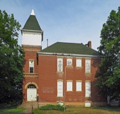 | Elysian Public School | 5.4 miles | 1981 |
| National Archives record | The nomination case file for reference 82004709 in Record Group 79. |
| Le Sueur County | All 28 listed properties in this county. |