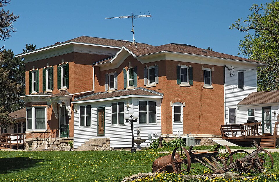
Built in 1873 (Italianate architecture). Listed on the National Register of Historic Places in 1984.
From the record
“The Benjamin Ellsworth House is a historic house in Utica, Minnesota, United States. It was built in 1873 for Benjamin Ellsworth (1826-1890), the founder of Utica.”
Wikipedia article Benjamin Ellsworth House, CC BY-SA 4.0.
One of 50 National Register listings published here for Winona County · listed in 1984 · category: Building · built in 1873, Italianate architecture.
National Register reference number.84001718- the number the National Park Service assigned this property when it was listed, and the key its nomination file is catalogued under at the National Archives.
The ground it stands on
2,913 words
The chapter on Utica City in History of Winona County, published 1883 names Utica. This is what it says, exactly as the scans read.
In 1855 nearly all the land was taken up by settlers. In the spring of this year came Austin Raymond, father of the brothers above named, Luzon, his son, James Myers, William H. D wight, Clayburn Cheatham, J. S. Lewis, David Wlietstine, Philip Ramer, and numerous others. The first death was that of an infant child of Peter Ramer, wliich occurred in April, 1855. In the fall of the same year Mrs. Clayburn Cheatham died of consumption. In October, 1856, Daniel Ramer, a brother of Philip, died of the same disease, and about the same time Mrs. Perry Miller passed away. In February, 1857, Steward Cook, one of the pioneers, was killed by a landslide from the bluff while going through a valley on the way to Winona. Steps were early taken to secure postal facilities, and a postoffice was established on the northeast quarter of Sec. 23, the fall of 1855, at the house of William H. Dwight. The business of the office was transacted by Collins Rice. Soon after this a postofiice was also established at Dr. Bentley's house, on Sec. 17, ^ with the doctor as postmaster. It is still related, as one of the examples of the style of business in those days, that the mail was kept in an old trunk, and anyone expecting mail was free to sort over the contents of said trunk, taking or leaving as he pleased. This was quite as "convenient" as Elder Ely's hat, in the early days of Winona. The two postofiices still maintained in the town are near the above original sites, namely, at the villages of Lewiston and Utica.
Among the settlers of 1855 were a number of Dunkard families, who sought to settle a community of their faith. They succeeded in so doing, and now have a neat and commodious church edifice, standing on the eastern side of the line dividing Utica from Warren township. Philip Ramer, one of these pioneers, was a preacher of this faith, and very soon after their arrival regular meetings of the sect were inaugurated. As early as May 20, 1855, Mr. Ramer preached at the house of J. S. Lewis. In July of the same year Rev. William Sweet preached in a grove in the central part of the town. In 1856 Mr. Ramer conducted religions services in the western part of the town, in a shanty built by Luzon Raymond on his first claim. The first school of which we can find any memory was taught in the summer of 1856 by Miss Elizabeth Sands, in Mr. Raymond's pre-emption shanty on Sec. 19. The next year a frame schoolhouse was built in the same locality, and a good-sized school occupied it.
Regional context, not property-specific
evidence. The
federal wildfire occurrence database
lists 18 fires within 5 miles of Benjamin Ellsworth House
between 1992 and 2007, burning about 72 acres in total. None started naturally. None was recorded as arson.
Distance is straight-line from the map coordinates, so a fire counted
here may appear on a neighbouring settlement's page as well.
Reported cause
Fires
Equipment and vehicle use
6
Railroad operations and maintenance
5
Debris and open burning
4
Smoking
3
The most recent of
them, most recent first, with the day each was reported and the service
that recorded it.
Regional context, not property-specific
evidence. The federal mineral resources record lists
2 workings within 5 miles of Benjamin Ellsworth House: 2 producers.
All of them still produce. What was taken out: Stone, Crushed/Broken. Distance is straight-line from the
map coordinates, so a quarry counted here may appear on a neighbouring
settlement's page as well.
Regional context, not property-specific
evidence. The National Weather Service names
Utica, the town this property stands in, in 21 storm reports between 1997 and 2024: 9 hail, 6 thunderstorm wind, 4 funnel cloud, 2 tornado.
No death or injury is recorded in these reports. Each account below is quoted exactly as the forecast office
filed it, from the NOAA Storm Events Database, and each date
opens the federal record of that event.
A fast moving and long track tornado began in St. Charles and produced EF-0 to EF-1 damage to farmsteads and trees in central Winona County. It then moved into Rollingstone, Minnesota were it damaged a few structures and caused widespread tree damage. The tornado continued northeast and crossed the Mississippi River into Buffalo County, Wisconsin where it dissipated.
Thunderstorm wind gusts produced damage to a farm near Utica. Thunderstorm wind gusts also knocked down several elm trees, a 50 foot steel windmill, and blew a metal roof off of a tractor shed.
No historic map-sheet match is published
for this property yet. That does not mean no map exists. This record needs
a coordinate-quality review before it can be joined to a sheet boundary.
Browse the county's mapped places while that work is
pending.
Listed places nearby
5 within 8 miles
Other National Register properties close
enough to walk or drive between, ordered by distance from this one. Both
positions come from the same geocoding pass that matched these properties
to their map sheets.
Listing record. National Park Service National Register of Historic Places, listed-properties dataset, current to 2026-05-22.
Map join. Address geocoded through the United States Census geocoder, then tested against the published boundary of every sheet in the USGS Historical Topographic Map Collection.
How this page is made. Listing fields come from federal records; map-sheet coverage is a labelled coordinate-to-boundary calculation, not a source-field claim.
Wildfire. Short, Karen C. 2022. Spatial wildfire occurrence data for the United States, 1992-2020 [FPA_FOD_20221014]. 6th Edition. Fort Collins, CO: Forest Service Research Data Archive. https://doi.org/10.2737/RDS-2013-0009.6 Collected with United States Government funding and usable without additional permissions or fees.
Mines and quarries. USGS Mineral Resources Data System (MRDS) https://mrdata.usgs.gov/mrds/ A work of the United States government, no copyright under 17 U.S.C. 105.
Storms. NOAA National Centers for Environmental Information, Storm Events Database https://www.ncei.noaa.gov/stormevents/ A work of the United States government, no copyright under 17 U.S.C. 105. Narratives are quoted verbatim from the National Weather Service report and are not edited or summarised.
 Block