 Block
From the record
One of 6 National Register listings published here for Polk County · listed in 1984 · category: District.
Sources: the case file at the National Archives · the National Register database, National Park Service
Listed on the National Register of Historic Places in 1984.
One of 6 National Register listings published here for Polk County · listed in 1984 · category: District.
Sources: the case file at the National Archives · the National Register database, National Park Service
Regional context, not property-specific evidence. The federal wildfire occurrence database lists 3 fires within 5 miles of Crookston Commercial Historic District between 2006 and 2012, burning about 22 acres in total. 1 started naturally. 1 was recorded as arson. Distance is straight-line from the map coordinates, so a fire counted here may appear on a neighbouring settlement's page as well.
| Reported cause | Fires |
|---|---|
| Natural | 1 |
| Equipment and vehicle use | 1 |
| Arson/incendiarism | 1 |
The most recent of them, most recent first, with the day each was reported and the service that recorded it.
| Date | Cause | Size | Reported by | Name on the report |
|---|---|---|---|---|
| 5 August 2006 | Natural | 1.0 acres | Detroit Lakes Wetland Management District | OLD LIGHTNING |
| 10 April 2006 | Equipment and vehicle use | 20 acres | Glacial Ridge | GLACIAL RIDGE 1 |
| 17 March 2012 | Arson/incendiarism | 1.3 acres | Minnesota Department of Natural Resources | not named |
Regional context, not property-specific evidence. The National Weather Service names Crookston, the town this property stands in, in 69 storm reports between 1994 and 2024: 38 hail, 20 thunderstorm wind, 7 flash flood, 2 tornado. No death or injury is recorded in these reports. Each account below is quoted exactly as the forecast office filed it, from the NOAA Storm Events Database, and each date opens the federal record of that event.
| When | Event | Place named | Harm | What the report says |
|---|---|---|---|---|
| May 2011 | Thunderstorm Wind | Crookston | $400,000 | There were many reports of damage around Crookston, with many trees, power lines, and street signs blown over. A small shed was blown down and falling tree limbs damaged the roofs of numerous homes. |
| July 2001 | Thunderstorm Wind | Crookston | $50,000 | Tree branches were blown down. |
| August 2001 | Thunderstorm Wind | Crookston | $50,000 | Many trees and powerlines were blown down and several buildings were damaged. One tree fell on a car, totalling it. A portion of a brick building was blown over. |
| May 2005 | Tornado (F2) | Crookston | $10,000 | A tornado touched down north of Crookston, and created a west-to-east damage path. The tornado hit a well-constructed pole barn and then travelled into an open field. Several large trees were snapped in half. The estimated peak wind speed was 140 mph. |
| May 2016 | Flash Flood | Crookston | $5,000 | Streets and fields were flooded by around four inches of rain in several hours. There were reports of kayaking in the flooded streets. |
| July 2001 | Flash Flood | Crookston | $2,000 | Street flooding was reported in Crookston. |
| June 2024 | Flash Flood | Crookston | $1,000 | Law Enforcement reports standing water in roads, resulting in impassable streets downtown. |
| March 2009 | Flash Flood | Crookston | $1,000 | no account filed |
| June 1999 | Thunderstorm Wind | Crookston | $500 | Several large trees were blown down. |
| August 2002 | Thunderstorm Wind | Crookston | $200 | Branches were blown down. |
| June 2024 | Thunderstorm Wind | Crookston | - | Law Enforcement reports trees down in various sizes around Crookston. |
| April 2023 | Flood | Crookston | - | Crookston gage, on the Red Lake River. Crested at 22.34 ft on April 17th at 14:55. |
| July 2019 | Thunderstorm Wind | Crookston | - | Large tree branches were blown down across the northern part of town. |
| June 2018 | Thunderstorm Wind | Crookston | - | Several large trees and a fence were blown down. |
| May 2016 | Hail | Crookston | - | The hail started as dime size and slowly got larger. |
| May 2016 | Hail | Crookston | - | The hailstones were possibly formed by several smaller stones merging together aloft. |
| July 2014 | Thunderstorm Wind | Crookston | - | A personal weather station recorded a wind gust of 80 mph. The strong winds wrecked havoc on the trees in the city of Crookston. |
| July 2011 | Thunderstorm Wind | Crookston | - | Large tree branches were blown down throughout Crookston. A door was also blown in at the Hugos grocery store. Wind speeds were estimated at 60 to 70 mph. |
| July 2009 | Hail | Crookston | - | The hail was reported at the University of Minnesota Crookston. |
| September 2007 | Hail | Crookston | - | The ground was covered with hail. |
| August 2007 | Thunderstorm Wind | Crookston | - | Zero visibility was reported in very high winds and rain. |
| August 2007 | Thunderstorm Wind | Crookston | - | Large tree limbs and power lines were blown down along the Polk and Red Lake County line. |
| June 2006 | Thunderstorm Wind | Crookston | - | Large tree branches were blown down near the University of Minnesota Crookston campus. |
| June 2005 | Thunderstorm Wind | Crookston | - | The roof was torn off a barn and two steel grain bins were blown down. |
| June 2005 | Thunderstorm Wind | Crookston | - | Several large trees were blown down by the strong wind. Shingles were torn off two homes. |
| June 2005 | Thunderstorm Wind | Crookston | - | The roofing and sidewalls were violently torn from two pole sheds and blown to the east. Numerous trees were uprooted or snapped off. |
| June 2003 | Thunderstorm Wind | Crookston | - | A 6 inch diameter tree was blown down. |
| June 2002 | Flash Flood | Crookston | - | Numerous county roads were under water. |
| June 2002 | Lightning | Crookston | - | A lightning strike knocked out the Polk county 911 system. |
| June 2002 | Flash Flood | Crookston | - | U.S. Highway 2 was covered with water. |
| August 2002 | Flash Flood | Crookston | - | Water flowed over county roads. |
| June 2000 | Hail | Crookston | - | Hail completely covered the ground. |
| June 1994 | Thunderstorm Wind | Crookston | - | A 19-year-old man was struck by lightning while driving a motorcycle along Highway 2 near Erskine and was killed. Another 17-year-old cyclist, traveling alongside the other, was injured. |
| June 1994 | Thunderstorm Wind | Crookston | - | Several trees were blown down by strong thunderstorm winds. |
| September 2020 | Hail | Crookston | - | no account filed |
| May 2018 | Hail | Crookston | - | no account filed |
| June 2010 | Hail | Crookston | - | no account filed |
| July 2009 | Hail | Crookston | - | no account filed |
| July 2009 | Hail | Crookston | - | no account filed |
| July 2009 | Hail | Crookston | - | no account filed |
| July 2009 | Hail | Crookston | - | no account filed |
| July 2009 | Hail | Crookston | - | no account filed |
| August 2006 | Hail | Crookston | - | no account filed |
| August 2006 | Hail | Crookston | - | no account filed |
| May 2005 | Hail | Crookston | - | no account filed |
| May 2005 | Hail | Crookston | - | no account filed |
| September 2005 | Hail | Crookston | - | no account filed |
| May 2004 | Thunderstorm Wind | Crookston | - | no account filed |
| June 2004 | Hail | Crookston | - | no account filed |
| September 2003 | Hail | Crookston | - | no account filed |
| September 2003 | Hail | Crookston | - | no account filed |
| April 2002 | Hail | Crookston | - | no account filed |
| June 2002 | Hail | Crookston | - | no account filed |
| May 2001 | Hail | Crookston | - | no account filed |
| August 2001 | Hail | Crookston | - | no account filed |
| August 2001 | Hail | Crookston | - | no account filed |
| September 2001 | Hail | Crookston | - | no account filed |
| August 2001 | Hail | Crookston | - | no account filed |
| August 2001 | Hail | Crookston | - | no account filed |
| June 1998 | Hail | Crookston | - | no account filed |
No historic map-sheet match is published for this property yet. That does not mean no map exists. This record needs a coordinate-quality review before it can be joined to a sheet boundary. Browse the county's mapped places while that work is pending.
Other National Register properties close enough to walk or drive between, ordered by distance from this one. Both positions come from the same geocoding pass that matched these properties to their map sheets.
| Photograph | Property | Distance | Listed |
|---|---|---|---|
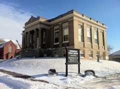 | Crookston Carnegie Public Library | under 500 feet | 1984 |
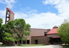 | Cathedral of the Immaculate Conception | under 500 feet | 1998 |
 | E. C. Davis House | 0.6 miles | 1984 |
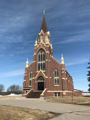 | Church of St. Peter-Catholic | 7.4 miles | 1982 |
| National Archives record | The nomination case file for reference 84002709 in Record Group 79. |
| Polk County | All 6 listed properties in this county. |