
BlockBefore
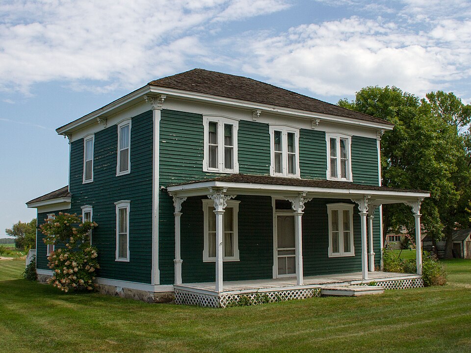
Photograph of Sabin S. Murdock House
Photograph by Bobak Ha'Eri, CC BY-SA 3.0. Via Wikimedia Commons.

Sabin S. Murdock House

Built in 1878. Listed on the National Register of Historic Places in 1985.

From the record

“Murdock House was a historic house in Murdock, Minnesota, United States. Murdock (1830-1900), who almost singlehandedly founded and promoted the community he named after himself.”

Wikipedia article Sabin S. Murdock House, CC BY-SA 4.0.

One of 9 National Register listings published here for Swift County · listed in 1985 · category: Building · built in 1878.

Sources: the Wikipedia article · the case file at the National Archives · the National Register database, National Park Service
The listing

  • What is counted as historic. The nomination lists 7 structuress, 3 buildingss as contributing to the listing.
  • Listed as. Murdock, Sabin S., House - the National Register files a house under its owner's surname.
  • Address. Clara Ave., Murdock, 56271
  • When was it listed? August 1985
  • Category. building
  • Township. Dublin township
  • When was it built? 1878
  • National Register reference number. 85001752 - the number the National Park Service assigned this property when it was listed, and the key its nomination file is catalogued under at the National Archives.

Storms near this property

13 since 1999

Regional context, not property-specific evidence. The National Weather Service names Murdock, the town this property stands in, in 13 storm reports between 1999 and 2025: 5 thunderstorm wind, 3 hail, 3 tornado, 2 funnel cloud. No death or injury is recorded in these reports. Each account below is quoted exactly as the forecast office filed it, from the NOAA Storm Events Database, and each date opens the federal record of that event.

WhenEvent Place namedHarm What the report says
September 2017Tornado (EF1)Murdock$1,500,000A tornado touched down in a corn field northwest of Murdock and moved northeast. The first structure that was hit was a church, which lost part of its roof. Along the way, the tornado destroyed corn fields, knocked down or broke many trees, and blew apart six empty grain bins that were ready for harvest. Three machine or equipment storage sheds were also destroyed and the roof of a restaurant was partially torn off. The tornado then moved into Kandiyohi County (see separate entry).
May 2022Thunderstorm WindMurdock$250,000Social media pictures and video of a dairy farm damaged near Murdock.
May 2015Tornado (EF1)Murdock$50,000Tornado mostly moved across open fields, but it also hit a farmstead, blowing out windows, knocking down power lines, and destroying an outbuilding. The tornado was recorded on video by numerous storm chasers.
June 2025Thunderstorm WindMurdock-Sherriff Dispatch reported tree damage 1 mile S of Murdock.
August 2019Funnel CloudMurdock-A storm spotter photographed a funnel that seemed to be close to the ground. It may have touched down but the chaser was too far away (12 miles across rolling terrain) and noted no debris cloud. Nobody who was closer to the storm saw the funnel touch down.
September 2017Thunderstorm WindMurdock-Numerous trees were blown down in the city of Murdock. Some of the trees were one foot in diameter. Due to several of the trees knocking down power lines, a large portion of Murdock lost power.
May 2015Tornado (EF0)Murdock-Tornado touched down in open field. It was recorded on video by multiple storm chasers. The tornado moved toward the southeast, even though its parent storm was moving north-northeast.
June 2010HailMurdock-Several areas from north of Murdock, to southwest of Sunburg had hail up to golf ball size.
May 2004HailMurdock-Dime to golf ball sized hail covered the ground.
June 2003HailMurdock-Hail fell on newly planted crops.
June 2001Thunderstorm WindMurdock-Several sheds down, some siding off homes, numerous trees down, mostly on western side of town.
July 2001Thunderstorm WindMurdock-Numerous trees down along a 12 mile long swath.
July 1999Funnel CloudMurdock-no account filed

Every storm recorded in Swift County

Map coverage status

No historic map-sheet match is published for this property yet. That does not mean no map exists. This record needs a coordinate-quality review before it can be joined to a sheet boundary. Browse the county's mapped places while that work is pending.

Listed places nearby

1 within 8 miles

Other National Register properties close enough to walk or drive between, ordered by distance from this one. Both positions come from the same geocoding pass that matched these properties to their map sheets.

Photograph PropertyDistance Listed
Church of St. Bridget-Catholic4.5 miles1985

Sources for this property

National Archives recordThe nomination case file for reference 85001752 in Record Group 79.
Wikipedia articleCommunity-written account of this property, licensed CC BY-SA.
Swift CountyAll 9 listed properties in this county.

Provenance

  • Listing record. National Park Service National Register of Historic Places, listed-properties dataset, current to 2026-05-22.
  • Map join. Address geocoded through the United States Census geocoder, then tested against the published boundary of every sheet in the USGS Historical Topographic Map Collection.
  • How this page is made. Listing fields come from federal records; map-sheet coverage is a labelled coordinate-to-boundary calculation, not a source-field claim.
  • Storms. NOAA National Centers for Environmental Information, Storm Events Database https://www.ncei.noaa.gov/stormevents/ A work of the United States government, no copyright under 17 U.S.C. 105. Narratives are quoted verbatim from the National Weather Service report and are not edited or summarised.