 Block
From the record
9 National Register listings published here.
Sources: the National Register database, National Park Service
28 topographic sheets cover 10 settlements here, and 9 properties are on the National Register of Historic Places.
9 National Register listings published here.
Sources: the National Register database, National Park Service
Every property in this county listed on the National Register of Historic Places, with the year it was listed and the federal nomination document.
| Photograph | Property | Type | Listed | Reference |
|---|---|---|---|---|
 | Appleton City Hall | building | 1977 | 77000770 |
 | Christ Church-Episcopal | building | 1985 | 85001761 |
 | Church of St. Bridget-Catholic | building | 1985 | 85001768 |
 | Church of St. Francis Xavier-Catholic | building | 1985 | 85001753 |
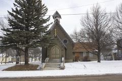 | Gethsemane Episcopal Church | building | 2011 | 11000469 |
 | Monson Lake State Park CCC/WPA/Rustic Style Historic Resources | district | 1989 | 89001666 |
 | Sabin S. Murdock House | building | 1985 | 85001752 |
 | Swift County Courthouse | building | 1977 | 77000771 |
| Christian F. Uytendale Farmstead | district | 1985 | 85001989 |
Every wildfire the federal occurrence database records inside this county: 10 of them, burning about 1,038 acres. None started naturally and 1 was recorded as arson. Each settlement page carries the fires within five miles of it.
| Reported cause | Fires |
|---|---|
| Debris and open burning | 4 |
| Missing data/not specified/undetermined | 3 |
| Arson/incendiarism | 1 |
| Recreation and ceremony | 1 |
| Equipment and vehicle use | 1 |
The five largest, by the area the report gives. One of them was set deliberately.
| Date | Cause | Size | Reported by | Name on the report |
|---|---|---|---|---|
| 11 October 2000 | Debris and open burning | 847 acres | Morris National Wildlife Refuge | SVOR |
| 14 October 2006 | Equipment and vehicle use | 85 acres | Minnesota Department of Natural Resources | not named |
| 19 December 2011 | Missing data/not specified/undetermined | 36 acres | Morris National Wildlife Refuge | WELSH |
| 4 May 2015 | Debris and open burning | 36 acres | Minnesota Department of Natural Resources | not named |
| 8 November 2020 | Arson/incendiarism | 27 acres | Minnesota Department of Natural Resources | not named |
| 30 May 1992 | Debris and open burning | 4.4 acres | Morris National Wildlife Refuge | ARTICHOKE |
| 2 May 1992 | Debris and open burning | 1.0 acres | Minnesota Agency | not named |
| 3 May 2008 | Missing data/not specified/undetermined | 1.0 acres | Minnesota Department of Natural Resources | not named |
Every settlement page carries the fires within five miles of it - see the settlement index below.
The NOAA Storm Events Database holds 272 reports for this county, causing no deaths, 8 injuries and about $17,267,000 in recorded property damage. Each settlement page carries the reports that name it.
| Kind of event | Reports |
|---|---|
| Thunderstorm Wind | 104 |
| Hail | 96 |
| Tornado | 51 |
| Funnel Cloud | 15 |
| Flood | 3 |
| Flash Flood | 3 |
The most serious of them, by death, then injury, then recorded damage. The accounts are quoted exactly as the forecast office filed them.
| When | Event | Place named | Harm | What the report says |
|---|---|---|---|---|
| June 2001 | Tornado (F2) | Benson | 7 hurt, $10,000,000 | After several brief tornadoes around Danvers, a much larger tornado struck the east side of Benson and travelled southeast along Highway 212. 71 structures were damaged, including 4 homes and 7 businesses that had to be demolished. The tornado lifted off in DeGraff, but not before damaging one last grain bin, taking the roof off a grain elevator, and knocking several sheds down in DeGraff. Seven people were injured when they fled a van just as the tornado was hitting the vehicle on the eastern edge of Benson. One boy was critically injured but survived and was discharged from the hospital two weeks later. Damage listed encompasses damages from all tornadoes and wind events in Swift County. |
| July 2015 | Thunderstorm Wind | Swift Falls | 1 hurt | A large tree limb was blown off and landed on a tent in the Swift Falls Campground. One individual was injured in the tent. |
| June 1952 | Tornado (F2) | not stated | $2,500,000 | no account filed |
| September 2017 | Tornado (EF1) | Murdock | $1,500,000 | A tornado touched down in a corn field northwest of Murdock and moved northeast. The first structure that was hit was a church, which lost part of its roof. Along the way, the tornado destroyed corn fields, knocked down or broke many trees, and blew apart six empty grain bins that were ready for harvest. Three machine or equipment storage sheds were also destroyed and the roof of a restaurant was partially torn off. The tornado then moved into Kandiyohi County (see separate entry). |
| September 2017 | Tornado (EF1) | Swift Falls | $800,000 | A tornado touched down southwest of Camp Lake, where it hit some trees at a farmstead. It then moved across fields, damaging or destroying corn fields. It partially tore the roof off a turkey barn before hitting homes along the east side of Camp Lake. It was here that an observer reported his flag was blowing hard from the northwest as tennis ball size hail hit, then the flag suddenly switched and was blowing from the southeast while the hail continued, then from the southwest when the tornado moved in. One modular home had windows blown in, a porch blown away, and its roof was uplifted to the point where driving rain got into much of the house. The tornado then hit an abandoned farm, rolling a mobile home and destroying several outbuildings before moving into Pope County (see separate entry). |
| July 1997 | Thunderstorm Wind | Benson | $500,000 | Three 50,000 bushel grain bins blown onto highway. Wall collapse at ethanol plant. Damage estimate for entire county. |
| April 2001 | Flash Flood | Countywide | $500,000 | no account filed |
| May 2022 | Thunderstorm Wind | Murdock | $250,000 | Social media pictures and video of a dairy farm damaged near Murdock. |
| June 2013 | Thunderstorm Wind | Benson Arpt | $250,000 | A 74 knot wind gust was measured at the Benson Airport. In addition, numerous trees were blown down in Benson, including some on houses and vehicles. |
| July 2009 | Tornado (EF2) | Swift Falls | $250,000 | A National Weather Service storm survey and visual reports confirmed that a tornado moved through portions of Swift and Pope Counties in west central Minnesota where two turkey barns and several outbuildings were destroyed, with extensive tree damage throughout the entire path. Maximum damage was EF-2 with estimated winds of 111-119 mph. In the town of Swift Falls, two residences were damaged along with two garages that were destroyed. The tornado was produced minor crop damage northeast of Swift Falls. |
| June 2013 | Thunderstorm Wind | Danvers | $200,000 | Numerous trees were blown down in Danvers, including downed trees on homes and vehicles. |
| May 2022 | Thunderstorm Wind | Appleton Arpt | $100,000 | An empty grain bin was lofted and blown about 300 feet into a field. Several trees were uprooted or broken. Shingles were removed from a house. A brand new and large metal building system was completely ripped off its foundation and destroyed. |
| June 2013 | Thunderstorm Wind | Swift Falls | $100,000 | Numerous trees were blown down in Swift Falls, including damage to turkey barns around Swift Falls. |
| May 2022 | Thunderstorm Wind | Benson | $50,000 | Several trees were blown down and a steel building was damaged near the intersection of 40th Street and Highway 29 south of Benson. Dozens of downed trees were scattered across Benson. |
| August 2020 | Thunderstorm Wind | Danvers | $50,000 | A farm irrigator was tipped over and a grain bin caved in during the early morning. |
| May 2015 | Tornado (EF1) | Murdock | $50,000 | Tornado mostly moved across open fields, but it also hit a farmstead, blowing out windows, knocking down power lines, and destroying an outbuilding. The tornado was recorded on video by numerous storm chasers. |
| June 1994 | Tornado (F1) | De Graff | $50,000 | A tornado demolished a tool shed, garage, barn and uprooted tress on a farmstead. |
| May 1977 | Tornado (F1) | not stated | $25,000 | no account filed |
| September 1975 | Tornado (F1) | not stated | $25,000 | no account filed |
| August 1954 | Tornado (F2) | not stated | $25,000 | no account filed |
| July 2016 | Tornado (EF0) | Appleton Arpt | $20,000 | Two storm chasers recorded a tornado on video. Fire department spotters also reported this tornado, and in fact, two of them were very close to it as it moved from north to south, even moving to the southwest at times. It tipped over an irrigator, broke three power poles and a few trees, and tossed around an old appliance that was at the city dump near Highway 59 and 70th Street. Very little corn was damaged, 15 acres at most. |
| August 2020 | Thunderstorm Wind | Benson | $5,000 | Several large trees and power lines/poles were blown down around Benson, Minnesota. |
| May 2015 | Tornado (EF0) | Danvers | $5,000 | The tornado moved across open fields and into a wildlife management area, where a number of trees were broken or downed. The tornado also hit a farmstead, producing minor damage. It was recorded on video by two completely independent experienced storm chasers. Times and locations of both chasers were checked very carefully, as radar only showed a weak echo north of Danvers at the time of the tornado. |
| June 2014 | Tornado (EF0) | Benson | $5,000 | A brief tornado touched down just to the northeast of Benson. It took the roof off a shed and hit a grove of trees but caused no other damage. It drew water upward from a slough and then soon thereafter dropped all the water and debris when the tornado dissipated. The tornado was recorded on photos and video. |
| July 2003 | Tornado (F1) | Danvers | $5,000 | Tornado ripped across open fields as well as several groves of trees. It brushed one farmstead southwest of Danvers, damaging a grain bin. |
| August 2021 | Thunderstorm Wind | Appleton | $2,000 | A few large tree branches and a power line were blown down in the city of Appleton. |
| May 2025 | Tornado (EF0) | Danvers | - | Video provided from storm chaser showed a condensation funnel and ground circulation. The tornado moved across a grove of trees and knocked down large trees. Its maximum wind was estimated at 75 mph. |
| May 2025 | Tornado (EF1) | Benson | - | A tornado developed approximately 3 miles to the SSE of Benson. Visible debris was reported by trained spotters and law enforcement. The tornado caused damage to some farm outbuildings before lifting just north of the intersection of US-12 and 10th St NE. Multiple damage photos and the detailed track were provided, so a virtual storm survey was conducted on this tornado. Its maximum wind was estimated at 95 mph. |
| June 2025 | Thunderstorm Wind | Swift Falls | - | Thunderstorm wind gust of 78 mph measured by MNDOT RWIS along Hwy 9. |
| June 2025 | Thunderstorm Wind | Appleton Arpt | - | A 61 mph gust was measured with personal weather station as a line of storms moved through western Swift County. |
| July 2025 | Thunderstorm Wind | Appleton Arpt | - | Measured by a MNDOT road weather station. |
| July 2025 | Thunderstorm Wind | Swift Falls | - | Measured by a MNDOT road weather station. It mainly recorded gusts near 59 mph between 15:25 and 15:55, but measured a 71 mph gust between 15:30 and 15:35. |
| August 2025 | Funnel Cloud | Danvers | - | Funnel cloud reported by a couple spotters. We have no report of it reaching the ground. |
| June 2025 | Tornado (EF1) | Danvers | - | A tornado developed just west of a farm and tracked east-southeast, before turning to the southeast and dissipating. At the farm, it damaged outbuildings, taking portions of the roofs and walls. It mangled trees, knocked over three irrigation pivots, and ripped through three turkey barns. Video was provided of the tornado. Photos and drone video of the damage were provided to determine the specific track. The maximum estimated wind was 100 mph. |
| June 2025 | Thunderstorm Wind | Murdock | - | Sherriff Dispatch reported tree damage 1 mile S of Murdock. |
| August 2024 | Funnel Cloud | Kerkhoven | - | Delayed report via X with photo attached. Time estimated from radar. |
| July 2024 | Thunderstorm Wind | De Graff | - | A semi was blown off Highway 29 just north of the Chippewa/Swift County line. |
| June 2024 | Funnel Cloud | Danvers | - | Funnel cloud photo submitted on social media. Time estimated via radar. |
| September 2023 | Funnel Cloud | Appleton Arpt | - | A broadcast meteorologist photographed a funnel cloud and shared it on social media. The funnel did not appear to have made ground contact. |
| May 2022 | Thunderstorm Wind | Appleton Arpt | - | Tree damage was noted near Holloway. Although winds were estimated at 60 mph, the Benson airport which is 10 miles east of this site had a measured wind gust of 54 mph at 6:56 PM CST. |
| May 2022 | Tornado (EF0) | Swift Falls | - | The tornado broke or uprooted dozens of trees. Tin was peeled off roofs and the sides of outbuildings. Trailers were tipped and various farm equipment heavily damaged. Some large tree branches were blown away rather than being downed next to the trees. Maximum winds were estimated at 75 mph. |
| May 2022 | Thunderstorm Wind | Appleton Arpt | - | Video showed an old church was blown off its foundation and overturned. Time estimated by radar. |
| May 2022 | Tornado (EF1) | Danvers | - | This tornado developed about 5 miles southwest of Danvers and tracked north until an outflow boundary caught up with it, then the tornado tracked northeast to 7 miles northwest of Clontarf. It originated in Swift County, then moved through the southeast corner of Stevens County, then into Pope County, where it dissipated. Several wooden poles with electrical transmission lines were snapped. Irrigation systems were overturned, trees were damaged, and some structural damage to homes and farm outbuildings also resulted. Maximum winds were estimated at 100 mph. |
| May 2022 | Thunderstorm Wind | Appleton | - | A survey team viewed the damage in Appleton but was unable to determine whether it was due to a downburst or tornado. Several dozen trees were broken. |
| May 2022 | Tornado (EF1) | Appleton | - | A tornado developed about 3 miles north-northwest of Milan in Chippewa County and then moved into Swift County where it uprooted a number of trees and significantly damaged farm outbuildings. Maximum winds for the Swift County portion were estimated at 90 mph. |
| May 2022 | Tornado (EF1) | Appleton Arpt | - | The tornado hit several farms. It broke some windows, knocked down or broke dozens of trees, tore tin off several sheds, and caused major damage to barns. Maximum winds were estimated at 90 mph. |
| May 2022 | Thunderstorm Wind | Benson | - | Several large trees were blown across Highway 9 near Benson. |
| September 2021 | Hail | Kerkhoven | - | Most of the hail was less than one inch in diameter. |
| August 2021 | Thunderstorm Wind | Appleton Arpt | - | A large tree blew down along Highway 12, or 4 miles north of Appleton. The tree damage was posted on social media. |
| August 2021 | Thunderstorm Wind | Benson Arpt | - | This was a measured wind gust at the Benson airport. No other damage occurred around the area. |
| July 2020 | Thunderstorm Wind | De Graff | - | A large tree limb was blown off and landed on U.S. Highway 12 near County Road 31. |
| August 2019 | Funnel Cloud | Murdock | - | A storm spotter photographed a funnel that seemed to be close to the ground. It may have touched down but the chaser was too far away (12 miles across rolling terrain) and noted no debris cloud. Nobody who was closer to the storm saw the funnel touch down. |
| July 2019 | Hail | Swift Falls | - | A swath of large hail fell along the the Pope, Swift County line. The largest hail stone reported was golf ball size. Damage occurred to corn fields along the path. |
| July 2018 | Funnel Cloud | Benson | - | The local police department reported funnel clouds west of Benson. |
| August 2018 | Thunderstorm Wind | Swift Falls | - | Several trees were blown down west of Sunburg. |
| June 2017 | Thunderstorm Wind | Kerkhoven | - | Trees and power lines were blown down. |
| September 2017 | Thunderstorm Wind | Swift Falls | - | About six evergreen trees were tipped over. Based on a storm survey, it was determined that this was due to rear flank downdraft winds, with the Camp Lake tornado about two-thirds mile to the north. |
| September 2017 | Thunderstorm Wind | Swift Falls | - | A few trees were damaged, a weak 4-legged metal tower was tipped over, and a shed was blown over. This area may have been an earlier beginning point of the Camp Lake tornado, but damage was too scant to be certain, and therefore this damage has been listed as thunderstorm wind damage. |
| September 2017 | Thunderstorm Wind | Murdock | - | Numerous trees were blown down in the city of Murdock. Some of the trees were one foot in diameter. Due to several of the trees knocking down power lines, a large portion of Murdock lost power. |
| September 2017 | Hail | Swift Falls | - | Hail fell on the northeast side of Camp Lake, just before the tornado hit. |
Named settlements recorded in the Geographic Names Information System, each with the topographic sheets covering it. Villages, hamlets and abandoned places alike. Each is shown with the nearest named watercourse or landform and the survey quadrangle it falls on.
Benson city · 56215 · On East Branch Chippewa River · Benson quadrangle
8 sheets, 1953 to 1986