BlockBefore
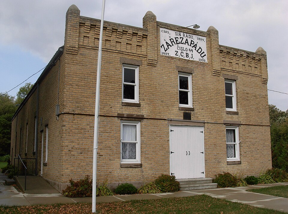
Photograph of Lodge Zare Zapadu
Photograph by Jonathunder, CC BY-SA 3.0. Via Wikimedia Commons.

Lodge Zare Zapadu No. 44

Built in 1909. Listed on the National Register of Historic Places in 1986.

From the record

One of 8 National Register listings published here for Freeborn County · listed in 1986 · category: Building · built in 1909.

Sources: the case file at the National Archives · the National Register database, National Park Service · the Wikipedia article

The listing

  • What is counted as historic. The nomination lists 1 building as contributing to the listing.
  • Address. CH 30, Hayward, 56036
  • When was it listed? March 1986
  • Category. building
  • Township. Hayward township
  • When was it built? 1909
  • National Register reference number. 86000479 - the number the National Park Service assigned this property when it was listed, and the key its nomination file is catalogued under at the National Archives.

The ground it stands on

701 words

The chapter on Hayward Township in History of Freeborn County, Minnesota, published 1911 names Hayward. This is what it says, exactly as the scans read.

This township, which has also borne the name of Douglass, is the southeast of the six interior towns of the county, and the towns in contact with it are : Riceland on the north, Oakland on the east, Shell Rock on the south, and Albert Lea on the west. It is six miles square, like all the other towns in the county. An arm of Lake Albert Lea, three miles long and a third of a mile wide, lies near the yestern boundary, in a north and south direc¬ tion. A stream called Peter Lunde creek enters the lake in sec¬ tion 7, made up of two branches arising back in the town. The land may be described as prairie, with oak openings and meadow land interspersed, the prairie predominating. The soil as a rule is a black loam, productive of all crops in this latitude. The sub¬ soil is clay and gravel. The town has one village, also known as Hayward.

Passage source: History of Freeborn County, Minnesota, published 1911.

Early Settlement. Oliver Andrews, who came to Shell Rock in 1855, located his claim in Hayward township. His friends, however, were in Shell Rock, and many efforts were made to have his farm remain a part of that township, instead of being included in Hayward. Peter Lunde and Endre Oulbrandson came here in 1856. Peter Lunde had located in Mitchell county, Iowa, in the early fifties. To his home, early in the spring of 1856, came Endre Gulbrandson, a native of Norway, but a resident of Wis¬ consin. Gulbrandson had left his Wisconsin home and brought his family as far as Houston county, Minnesota, where he left them for a time, while he pushed on to Mitchell, where his relative, Peter Lunde, resided. Together these men came to Hayward township and selected claims, later going after their families, who arrived during the middle of the summer. In 1856 William Newlin settled in section 7, William Eddy in section 18, A. T. and Philo Butts in section 20, S. H. Ludlow in section 8, and Freeman Briggs in section 20. The same year came David Hayward, from whom the town is named. He settled on section 6 and remained about two years. Lysander R. Luce came in 1857.

Passage source: History of Freeborn County, Minnesota, published 1911.

Machine-read from a century-old scan, so expect the errors a machine makes: misspelled names, dropped words, stray characters.

Read the whole chapter on Hayward Township - 701 words on its settlement, mills, schools and churches.

Fires near this property

1 since 2012

Regional context, not property-specific evidence. The federal wildfire occurrence database lists 1 fire within 5 miles of Lodge Zare Zapadu No. 44 in 2012, burning about 25 acres in total. None started naturally. None was recorded as arson. Distance is straight-line from the map coordinates, so a fire counted here may appear on a neighbouring settlement's page as well.

Reported cause Fires
Equipment and vehicle use1

The most recent of them, most recent first, with the day each was reported and the service that recorded it.

DateCause SizeReported by Name on the report
8 October 2012Equipment and vehicle use25 acresMinnesota Valley National Wildlife RefugeREST STOP

Every fire recorded in Freeborn County

Storms near this property

4 since 1998

Regional context, not property-specific evidence. The National Weather Service names Hayward, the town this property stands in, in 4 storm reports between 1998 and 2023: 2 tornado, 1 thunderstorm wind, 1 hail. No death or injury is recorded in these reports. Each account below is quoted exactly as the forecast office filed it, from the NOAA Storm Events Database, and each date opens the federal record of that event.

WhenEvent Place namedHarm What the report says
December 2021Tornado (EF0)Hayward-This tornado hit several farmsteads, partially removing the roofs of several outbuildings and a turkey barn. It dented a silo. Trees fell on a number of sheds and vehicles.
July 2019Thunderstorm WindHayward-A trained spotter measured a wind gust of 52 knots.
June 1998Tornado (F1)Hayward-Barn destroyed. Large power poles knocked down.
July 2023HailHayward-no account filed

Every storm recorded in Freeborn County

Map coverage status

No historic map-sheet match is published for this property yet. That does not mean no map exists. This record needs a coordinate-quality review before it can be joined to a sheet boundary. Browse the county's mapped places while that work is pending.

Sources for this property

National Archives recordThe nomination case file for reference 86000479 in Record Group 79.
Wikipedia articleCommunity-written account of this property, licensed CC BY-SA.
Freeborn CountyAll 8 listed properties in this county.

Provenance

  • Listing record. National Park Service National Register of Historic Places, listed-properties dataset, current to 2026-05-22.
  • Map join. Address geocoded through the United States Census geocoder, then tested against the published boundary of every sheet in the USGS Historical Topographic Map Collection.
  • How this page is made. Listing fields come from federal records; map-sheet coverage is a labelled coordinate-to-boundary calculation, not a source-field claim.
  • Wildfire. Short, Karen C. 2022. Spatial wildfire occurrence data for the United States, 1992-2020 [FPA_FOD_20221014]. 6th Edition. Fort Collins, CO: Forest Service Research Data Archive. https://doi.org/10.2737/RDS-2013-0009.6 Collected with United States Government funding and usable without additional permissions or fees.
  • Storms. NOAA National Centers for Environmental Information, Storm Events Database https://www.ncei.noaa.gov/stormevents/ A work of the United States government, no copyright under 17 U.S.C. 105. Narratives are quoted verbatim from the National Weather Service report and are not edited or summarised.