 Block
From the record
8 National Register listings published here.
Sources: the county history on the Internet Archive · the National Register database, National Park Service
28 topographic sheets cover 33 settlements here, and 8 properties are on the National Register of Historic Places.
8 National Register listings published here.
Sources: the county history on the Internet Archive · the National Register database, National Park Service
Every property in this county listed on the National Register of Historic Places, with the year it was listed and the federal nomination document.
| Photograph | Property | Type | Listed | Reference |
|---|---|---|---|---|
| Albert Lea City Hall | building | 1984 | 84001412 | |
| Albert Lea Commercial Historic District | district | 1987 | 87001214 | |
| Albert Lea Commercial Historic District (Boundary Increase and Decrease) | district | 2003 | 03001337 | |
| Milwaukee Chicago St. Paul and Pacific Railroad Depot | building | 1982 | 82002954 | |
 | Clarks Grove Cooperative Creamery | building | 1986 | 86000480 |
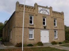 | Lodge Zare Zapadu No. 44 | building | 1986 | 86000479 |
| H. A. Paine House | building | 1986 | 86000481 | |
| Dr. Albert C. Wedge House | building | 1986 | 86001332 |
Every wildfire the federal occurrence database records inside this county: 7 of them, burning about 232 acres. None started naturally and 1 was recorded as arson. Each settlement page carries the fires within five miles of it.
| Reported cause | Fires |
|---|---|
| Debris and open burning | 4 |
| Equipment and vehicle use | 1 |
| Missing data/not specified/undetermined | 1 |
| Arson/incendiarism | 1 |
The five largest, by the area the report gives. One of them was set deliberately.
| Date | Cause | Size | Reported by | Name on the report |
|---|---|---|---|---|
| 25 April 2000 | Debris and open burning | 177 acres | Windom Wetland Management District | TWO ISLAND (RX/WF) |
| 8 October 2012 | Equipment and vehicle use | 25 acres | Minnesota Valley National Wildlife Refuge | REST STOP |
| 2 April 2003 | Debris and open burning | 17 acres | Windom Wetland Management District | TWIN LAKES |
| 16 April 2007 | Debris and open burning | 9.0 acres | Windom Wetland Management District | HALLS LAKE |
| 12 September 2017 | Arson/incendiarism | 2.4 acres | Minnesota Department of Natural Resources | not named |
| 1 May 2015 | Missing data/not specified/undetermined | 1.2 acres | Windom Wetland Management District | IOWA CHICAGO & EASTERN |
| 27 November 1999 | Debris and open burning | under an acre | Windom Wetland Management District | FOSTER CREEK |
Every settlement page carries the fires within five miles of it - see the settlement index below.
The NOAA Storm Events Database holds 441 reports for this county, causing 16 deaths, 99 injuries and about $153,897,410 in recorded property damage. Each settlement page carries the reports that name it.
| Kind of event | Reports |
|---|---|
| Thunderstorm Wind | 164 |
| Hail | 152 |
| Tornado | 70 |
| Funnel Cloud | 21 |
| Flash Flood | 16 |
| Flood | 10 |
| Heavy Rain | 7 |
| Lightning | 1 |
The most serious of them, by death, then injury, then recorded damage. The accounts are quoted exactly as the forecast office filed them.
| When | Event | Place named | Harm | What the report says |
|---|---|---|---|---|
| May 1953 | Tornado (F2) | not stated | 6 killed, 3 hurt, $2,500 | no account filed |
| April 1967 | Tornado (F4) | not stated | 5 killed, 35 hurt, $25,000,000 | no account filed |
| April 1967 | Tornado (F3) | not stated | 2 killed, 23 hurt, $25,000,000 | no account filed |
| June 2010 | Tornado (EF4) | Mansfield | 1 killed, 14 hurt | The tornado initially moved northeast to approximately 3.5 miles west of Conger, where at about (43.6156, -93.6015), it began to move more to the east-northeast. West of Armstrong, at about (43.6597, -93.4938), it began tracking nearly due north to just west of Manchester, where at about (43.7357, -93.4801), it began to move to the north-northwest, before dissipating 1.5 miles west of Hartland. Accounting for the changes in direction of this track, the actual path length covered by the tornado was 19.95 miles.||Near 180th Street and County Road 2, a home was likely in the outer circulation of the tornado, as it sustained some roof and siding damage. A barn was also destroyed to its brick foundation and a car was also flipped over lengthwise. Some evidence of tree debarking was noted. The tornado continued to the northeast and caused extensive crop damage approximately 500 yards in width. Near County Roads 17 and 63, the tornado intensified to produce EF-3 damage, impacting a farmstead and causing the complete destruction of three swine barns and the loss of 12 head of swine. Two empty grain bins were completely blown away at this location. The house at this location had some roof damage but appeared to be northwest of the main tornado path. Approximately 100 feet northeast of the house, a 150 foot tripod style wind turbine tower was twisted and toppled. This location also marked the beginning of crops being completely raked, with only stalks of corn left, and soybean fields being almost unrecognizable.||After passing through this farmstead the tornado took a more easterly path across County Road 63, and maintained EF-3 strength. After passing County Road 63, another farmstead was hit, and two empty harvester silos were toppled. The tornado continued to the northeast across County Road 4, where continued raking of the fields was noted with significant deposition of debris along the tornado path. Numerous trees were toppled at County Road 89 where it turns to the north. The tornado continued to the north-northeast, grew to 1000 yards, and around 1750 LST impacted a farmstead along County Road 12 two miles north of Conger, where EF-4 damage was observed. The house at this location was completely destroyed, as was the barn and several other buildings. Extensive tree damage was noted with nearly all branches being removed from the trunks. Debarking of trees was widespread at this location. A car was also tumbled a distance of 3200 feet, coming to rest in a field east of County Road 12.||The tornado continued to the northeast across County Road 69 and County Road 46, where it weakened slightly to EF-3 intensity. As it crossed County Road 46, a house was rotated off the foundation. The tornado was approximately 700 yards wide at this point. To the north-northeast, a swine barn was destroyed with sheet metal being carried off to Interstate 90. At this same time, a satellite tornado developed and caused damage in the town of Armstrong (see separate entry).||The main tornado continued to the north-northeast and was 500 yards in width. The tornado crossed County Road 74 and caused EF-2 damage to three farmsteads. One farmstead with a manufactured home was hit, resulting in one fatality and one severe injury. The tornado crossed Interstate 90 just west of County Road 14 as it grew to one third of a mile in width and re-strengthened to EF-3 intensity. Several farmsteads saw significant damage between Sugar Lake and County Road 14, with a house and two barns completely destroyed. From this point the tornado continued to the north, growing to one mile in width. Around 1800 LST, a house and barn were destroyed approximately one mile west of Manchester on County Road 25, where extensive tree and structural damage was also noted at several properties in the area. Additionally, west of this tornadic damage, a separate area of tree and structural damage was caused by strong thunderstorm winds associated with a rear flank downdraft (see separate entry).||About one mile north, the tornado weakened slightly to EF-2 Intensity, where it damaged three full grain bins near County Road 29. The tornado was approximately 1300 yards at this point. Further north, at County Road 95, the tornado continued to weaken, although a farmstead still received EF-1 damage to trees and structures. Finally, the tornado continued north and began to narrow and weaken. It dissipated west of Hartland. One person was killed and 14 injured from this tornado. |
| June 2008 | Flash Flood | Albert Lea | 1 killed, 2 hurt, $500,000 | Approximately three to five inches of heavy rain in three hours resulted in flash flooding. Water was reported over Highway 65 three miles southeast of Albert Lea, and over Interstate 90 five miles east and one mile north of Hayward. Heavy rain washed out a section of County Road 34 between County Roads 19 and 21, or about three miles south of Oakland. One man died when he drove into the washed out roadbed and the vehicle submerged. The first call to 911 came at 0005 CST June 12, alerting law enforcement that the road had washed out. Shortly thereafter, another call to 911 was placed when a vehicle with two occupants drove into the washed out roadbed. The two occupants were rescued but informed their rescuers that they had landed on a vehicle, which turned out to be the vehicle with the deceased 52 year old male. Two people died indirect deaths when, at night on June 29, at the same washed out location three miles south of Oakland, they either drove around a barricade or somebody had moved the barricade. The vehicle plunged into the cavernous hole. One woman died June 29 and a man died July 3. |
| April 1991 | Thunderstorm Wind | not stated | 1 killed | no account filed |
| June 1984 | Tornado (F3) | not stated | 12 hurt, $25,000,000 | no account filed |
| July 1952 | Tornado (F2) | not stated | 4 hurt, $25,000 | no account filed |
| May 2018 | Thunderstorm Wind | Geneva | 3 hurt, $50,000 | A NWS storm survey indicated that a severe downburst wind, with an estimated wind of 80 mph, occurred from near the intersection of 310th Street, and 820th Avenue, |north-northeast for approximately one mile. Several trees were uprooted, with a trailer and a turkey barn that were destroyed near the end of the path. Three injuries occurred, but were not life threatening. Other trees and power lines were blown down in the city of Geneva which is likely associated with another downburst around the same time. |
| June 1994 | Thunderstorm Wind | Albert Lea | 2 hurt, $5,000 | Severe thunderstorm winds blew over a semi trailer , while also knocking numerous large trees down in the city of Albert Lea. The observing site in Albert Lea clocked winds at 68 miles an hour. There were two people injured by falling trees. |
| October 1966 | Tornado (F2) | not stated | 1 hurt, $2,500 | no account filed |
| April 1967 | Tornado (F4) | not stated | $25,000,000 | no account filed |
| April 1967 | Tornado (F4) | not stated | $25,000,000 | no account filed |
| May 2001 | Tornado (F2) | Glenville | $20,000,000 | Tornado first touched down on the western fringe of Glenville, and produced major damage, especially on the northwest side of Glenville. There were 25 homes that sustained major damage, and 70 with minor damage. Damage survey indicated F2 damage on northwest side of Glenville, with F1 damage along rest of path. |
| June 1984 | Tornado (F1) | not stated | $2,500,000 | no account filed |
| May 2001 | Tornado (F2) | Oakland | $2,000,000 | Shortly after the Glenville tornado dissipated, another tornado formed 4 miles southwest of Oakland and dissipated about 1/2 mile before it would have crossed Interstate 90, which law enforcement had barricaded. Major damage to 3 farmsteads, minor damage to 8 others per damage survey. |
| June 2014 | Flood | Freeborn | $625,000 | In Albert Lea, West Main Street between Garfield Avenue and Newton Avenue were|closed due to flooding. Of the local lakes; flood waters submerged several islands. Boat docks were submerged along Fountain Lake, and six holes at Oak Island Disc Golf Course were unplayable due to flood waters. |
| July 2022 | Flash Flood | Gordonsville | $300,000 | Heavy rain caused flooding across much of western, southern, and central Freeborn County, with significant damage to numerous roads, bridges, and ditches in multiple townships, affecting areas in and near Shell Rock Watershed. Flooding caused major damage to two homes in Alden and two in Albert Lea, with walls collapsed. One more home in Albert Lea sustained minor damage. Local media also showed two vehicles fully submerged at the intersection of Franks Avenue and East 8th Street in Albert Lea. There were also cars submerged in a parking lot on Main Street and South Washington Avenue. |
| August 2016 | Thunderstorm Wind | Hollandale | $300,000 | A local broadcast Meteorologist storm survey indicated downburst wind damage on the west and south side of a tornado that formed briefly near Highway 251 and Zuyder Zee Avenue North. The damage was concentrated on the southern part of town between 830th Avenue and Highway 28th. |
| September 2016 | Flood | Freeborn | $280,000 | Runoff from torrential rainfall that occurred across most of northern Freeborn County Wednesday night, September 21st, caused numerous roads to remain impassable and closed. Local officials indicated that nearly 300 properties in Freeborn County had reported flood damage. Repair work for regrading and re-rocking gravel roads, replacing riprap and reimbursing cost were estimated at $280,000. |
| June 1984 | Tornado (F1) | not stated | $250,000 | no account filed |
| May 1982 | Tornado (F3) | not stated | $250,000 | no account filed |
| May 1982 | Tornado (F3) | not stated | $250,000 | no account filed |
| May 1980 | Tornado (F1) | not stated | $250,000 | no account filed |
| June 1973 | Tornado (F1) | not stated | $250,000 | no account filed |
| June 2014 | Thunderstorm Wind | (Ael)Albert Lea Arpt | $200,000 | A severe downburst produced considerable damage to a home residence. Damage included the loss of the roof, and structure damage throughout the home, including total destruction of their garage. |
| September 2010 | Flood | Bath | $190,000 | Numerous roads were closed due to excessive rainfall that fell on September 22nd and 23th. |
| June 2014 | Thunderstorm Wind | Alden | $100,000 | Several roofs were blown off sheds, and multiple grain bins were blown down around the city of Alden. |
| June 2013 | Flash Flood | Albert Lea | $100,000 | The City of Albert Lea had many streets barricaded due to water over the road. The streets in town was basically ponding due to saturated ground. Many stalled vehicles were reported. In the county there were several roads, including County Road 61 and County Road 27, near Freeborn, which had water over the road. The intersection of County Roads 14 and 74, north of Emmons, needed significant repairs. |
| September 2012 | Thunderstorm Wind | Armstrong | $100,000 | A large tree fell on a house in Albert Lea. In addition, there were reports of widespread tree damage across parts of Freeborn County, along with power outages. |
| July 2019 | Thunderstorm Wind | Albert Lea | $50,000 | There was widespread tree damage, and some roof damage to commercial buildings around Albert Lea, and then eastward toward Hayward, and Glenville. |
| June 2012 | Thunderstorm Wind | Conger | $50,000 | Severe winds caused a roof of a home to blow off, along with a large grain bin destroyed. |
| June 2010 | Thunderstorm Wind | Albert Lea | $50,000 | Numerous trees and power lines were blown down. |
| May 2001 | Tornado (F1) | Oakland | $50,000 | The third tornado in a series (the first one started at Glenville) formed just north of Interstate 90 and east of Oakland. It was on the ground for one mile in Freeborn County before crossing into Mower County, where it dissipated 4 N Austin (see Storm Data for southeast Minnesota). A few grain bins were blown down. |
| June 2020 | Thunderstorm Wind | Hollandale | $25,000 | A shed and home were damaged in Hollandale. There was also several power poles blown down around the area. |
| July 2016 | Thunderstorm Wind | Albert Lea | $25,000 | Numerous trees and power lines were blown down across the city of Albert Lea. Some of the worst areas were near the fairgrounds where barn doors were damaged and a vehicle was damaged due to a fallen tree. |
| June 2010 | Thunderstorm Wind | Manchester | $25,000 | Several large trees were blown down, plus a garage door was damaged. This damage was associated with the rear flank downdraft associated with the EF-4 tornado that began near Mansfield. |
| August 2019 | Thunderstorm Wind | Manchester | $10,000 | A barn was damaged due to severe straight-line winds near Manchester. |
| May 2015 | Thunderstorm Wind | Albert Lea | $10,000 | Several reports were received from state officials of windows blown out, trees and power lines knocked down around Albert Lea. |
| June 2013 | Thunderstorm Wind | Alden | $10,000 | Several trees were blown down in North Park, plus a garage was blown down on County Road 51, east of Alden. |
| August 2010 | Thunderstorm Wind | (Ael)Albert Lea Arpt | $10,000 | Several large trees and power lines were blown down on the northside of Albert Lea, Minnesota. The local AWOS airport measured a wind gust of 59 mph near the same time. |
| June 2001 | Flash Flood | Albert Lea | $10,000 | Numerous streets and basements flooded. |
| August 2014 | Thunderstorm Wind | Albert Lea | $5,000 | A large tree blew down on a vehicle. |
| March 2012 | Thunderstorm Wind | (Ael)Albert Lea Arpt | $5,000 | Severe thunderstorm winds caused a grain bin, approximately 15 feet tall, to collapse north of Albert Lea, Minnesota. |
| June 1994 | Thunderstorm Wind | Twin Lakes | $5,000 | Winds were estimated at over 70-miles-an-hour near Twin Lakes and Conger. Golf ball-size hail fell in the Twin Lakes area. |
| June 1994 | Hail | Alden | $5,000 | Dime-size hail and major tree damage was reported from the city of Alden. Along with downed trees, structural damage had occurred to some of the buildings in town. |
| June 1994 | Thunderstorm Wind | Alden | $5,000 | Dime-size hail and major tree damage was reported from the city of Alden. Along with downed trees, structural damage had occurred to some of the buildings in town. |
| June 1994 | Hail | Twin Lakes | $5,000 | Winds were estimated at over 70-miles-an-hour near Twin Lakes and Conger. Golf ball-size hail fell in the Twin Lakes area. |
| July 2016 | Lightning | Freeborn | $3,000 | An attic fire was reported about three quarters of a mile north of Freeborn. It was caused by a lightning strike at about 2:30 a.m. cst. A husband and wife were home at the time of the fire, but were able to leave the house safely. The damage was estimated to be close to $3,000. |
| July 1974 | Tornado (F0) | not stated | $2,500 | no account filed |
| September 1958 | Tornado (F1) | not stated | $2,500 | no account filed |
| June 2009 | Tornado (EF0) | Geneva | $1,000 | Several storm spotters and local law enforcement officials watched a nearly continuous wall cloud and/or funnel cloud move across northern Freeborn County before forming a tornado near Geneva. Several trees and two sheds were damaged on the northeast corner of Interstate 35 and County Road 35, on the west edge of Geneva. Debris was occasionally noted underneath the condensation funnel cloud as it trekked to the east-southeast. There was minor tree damage associated with the tornado on the east side of Geneva, with the last damage just south of the intersection of County Roads 26 and 35. |
| May 1995 | Thunderstorm Wind | Emmons | $1,000 | Strong thunderstorm winds caused minor roof damage and blew down an abandoned and derelict barn. Fourteen trees were also damaged. |
| July 2022 | Thunderstorm Wind | Alden | $500 | Several large tree branches were blown down in the city of Alden. |
| July 1994 | Thunderstorm Wind | Austin | $500 | Numerous large tree limbs were knocked down by thunderstorm winds across the Austin area. |
| June 1994 | Hail | Hartland | $500 | Dime-size hail and wind gusts to 60 miles an hour were reported in city of Hartland. |
| June 1994 | Thunderstorm Wind | Hartland | $500 | Dime-size hail and wind gusts to 60 miles an hour were reported in city of Hartland. |
| June 1986 | Tornado (F0) | not stated | $250 | no account filed |
| May 1994 | Hail | Albert Lea | $50 | A severe thunderstorm dumped dime-size hail across much of southern Freeborn County. |
| May 1994 | Hail | Albert Lea | $50 | A severe thunderstorm dumped dime-size hail across much of southern Freeborn County. |
The Survey's mineral resources record lists 18 workings inside this county. 17 still produce and 1 is closed or unrecorded. Each settlement page carries the workings within five miles of it.
| Commodity | Workings |
|---|---|
| Sand and Gravel, Construction | 17 |
| Limestone, General | 1 |
The least common of them first, because a county's hundredth gravel pit says nothing its first ten did not.
| Where | Site | Commodity | Status | Recorded |
|---|---|---|---|---|
| Freeborn County Marl Bed | Limestone, General | Occurrence | ||
| Don Wayne | Sand and Gravel, Construction | Producer | ||
| Don Wayne Pit | Sand and Gravel, Construction | Producer | ||
| Dunbar Pit and Mill | Sand and Gravel, Construction | Producer | ||
| Hans Hanson Pit | Sand and Gravel, Construction | Producer | ||
| Jande Pit | Sand and Gravel, Construction | Producer | ||
| Janke Mill | Sand and Gravel, Construction | Producer | ||
| Jenson Pit & Plant | Sand and Gravel, Construction | Producer | ||
| Lee Pit | Sand and Gravel, Construction | Producer | ||
| Nelson Pit & Mill | Sand and Gravel, Construction | Producer | ||
| Nickerson Pit & Plant | Sand and Gravel, Construction | Producer | ||
| Olson Pit Wash Plant & Mill | Sand and Gravel, Construction | Producer | ||
| Perkins Pit | Sand and Gravel, Construction | Producer | ||
| Ron Thompson Pit & Plant | Sand and Gravel, Construction | Producer | ||
| Sanderson Pit | Sand and Gravel, Construction | Producer | ||
| Spinler Pit & Plant | Sand and Gravel, Construction | Producer | ||
| Ulland Pit | Sand and Gravel, Construction | Producer | ||
| Vanderhorse Pit & Plant | Sand and Gravel, Construction | Producer |
History of Freeborn County, Minnesota devotes a chapter to each township: its boundaries and streams, who settled it and when, the mills, the schools and the churches. All 15 are reproduced here in full. Each row shows the township's own shape and where it lies in the county, drawn from the Census Bureau's boundary. Which settlements belong to which township is computed from that same boundary, not taken from the book.
| Shape and position in the county | Township | Settlements in it | Length | Sections |
|---|---|---|---|---|
| Albert Lea Township | Albert Lea, Murtaugh, Stoney Creek Estates | 2,820 words | 4 | |
| Alden City | Alden | 5,685 words | 4 | |
| Bancroft Township | Bancroft | 1,747 words | 0 | |
| Bath Township | Bath | 2,353 words | 0 | |
| Freeborn City | Freeborn | 2,397 words | 0 | |
| Geneva Township | Geneva | 1,451 words | 0 | |
| Hartland Township | Hartland | 1,272 words | 0 | |
| Hayward Township | Hayward, Hollandale Junction, Petran | 701 words | 0 | |
| London Township | London | 900 words | 0 | |
| Manchester City | Manchester | 1,712 words | 1 | |
| Mansfield Township | Mansfield | 4,663 words | 0 | |
| Newry Township | Maple Island | 1,554 words | 0 | |
| Pickerel Lake Township | Armstrong | 5,611 words | 8 | |
| Riceland Township | Lerdal, Muckland, Sigsbee, South Hollandale, Twin Grove | 1,103 words | 0 | |
| Shell Rock Township | Gordonsville | 1,742 words | 0 |
2 books written about this county, cut here where the book itself is cut, at its printed chapters: 91 chapters in all. Every chapter is public domain, machine-read from the scan and reproduced complete. A chapter already given under one of the county's towns is not repeated in this list.
Named settlements recorded in the Geographic Names Information System, each with the topographic sheets covering it. Villages, hamlets and abandoned places alike. Each is shown with the nearest named watercourse or landform and the survey quadrangle it falls on.
Albert Lea city · 56007 · Near Katherine Island · Albert Lea East quadrangle
10 sheets, 1954 to 1985
Shell Rock township · 56036 · On Goose Creek · Glenville quadrangle
10 sheets, 1954 to 1985