
BlockBefore
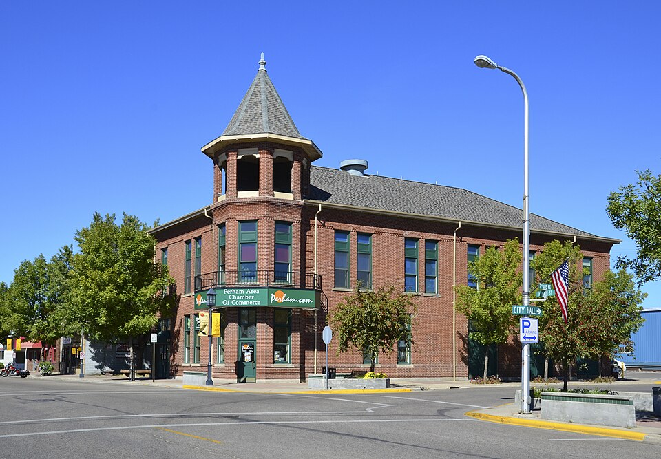
Photograph of Perham Village Hall and Fire Station
Photograph by Elizabeth A. Armour, CC BY-SA 3.0. Via Wikimedia Commons.

Perham Village Hall and Fire Station

Listed on the National Register of Historic Places in 1986.

From the record

“Perham Village Hall and Fire Station, also known as the Perham Area Chamber of Commerce, is a historic building located in Perham, Minnesota, United States. Completed in 1906, the two-story brick structure replaced the old village hall that was in need of repair.”

Wikipedia article Perham Village Hall and Fire Station, CC BY-SA 4.0.

One of 27 National Register listings published here for Otter Tail County · listed in 1986 · category: Building.

Sources: the Wikipedia article · the case file at the National Archives · the National Register database, National Park Service

The listing

  • What is counted as historic. The nomination lists 1 building as contributing to the listing.
  • Address. 153 E. Main, Perham, 56573
  • When was it listed? July 1986
  • Category. building
  • Township. Perham township
  • National Register reference number. 86002122 - the number the National Park Service assigned this property when it was listed, and the key its nomination file is catalogued under at the National Archives.

The ground it stands on

22 words

This property stands in Perham Township. Otter Tail County, Minnesota, in the World War;, published 1919 gives that township a chapter of its own.

The chapter covers the township.

Machine-read from a century-old scan, so expect the errors a machine makes: misspelled names, dropped words, stray characters.

Read the whole chapter on Perham Township - 22 words on its settlement, mills, schools and churches.

Fires near this property

19 since 1999

Regional context, not property-specific evidence. The federal wildfire occurrence database lists 19 fires within 5 miles of Perham Village Hall and Fire Station between 1999 and 2020, burning about 251 acres in total. None started naturally. 1 was recorded as arson. Distance is straight-line from the map coordinates, so a fire counted here may appear on a neighbouring settlement's page as well.

Reported cause Fires
Equipment and vehicle use10
Debris and open burning3
Missing data/not specified/undetermined2
Railroad operations and maintenance2
Smoking1
Arson/incendiarism1

The most recent of them, most recent first, with the day each was reported and the service that recorded it.

DateCause SizeReported by Name on the report
4 September 2003Equipment and vehicle useunder an acreMinnesota Department of Natural Resourcesnot named
12 July 2002Smokingunder an acreMinnesota Department of Natural Resourcesnot named
10 June 2017Missing data/not specified/undeterminedunder an acreMinnesota Department of Natural Resourcesnot named
21 May 2010Equipment and vehicle useunder an acreMinnesota Department of Natural Resourcesnot named
21 May 2002Equipment and vehicle useunder an acreMinnesota Department of Natural Resourcesnot named
12 May 2020Debris and open burningunder an acreMinnesota Department of Natural Resourcesnot named
1 May 2003Arson/incendiarismunder an acreMinnesota Department of Natural Resourcesnot named
25 April 2020Debris and open burningunder an acreMinnesota Department of Natural Resourcesnot named

Every fire recorded in Otter Tail County

Mines and quarries near this property

1 within 5 miles

Regional context, not property-specific evidence. The federal mineral resources record lists 1 working within 5 miles of Perham Village Hall and Fire Station: 1 producer. All of them still produce. What was taken out: Sand and Gravel, Construction. Distance is straight-line from the map coordinates, so a quarry counted here may appear on a neighbouring settlement's page as well.

Where SiteCommodity StatusRecorded
Perham Ready Mix Pit and MillSand and Gravel, ConstructionProducer

Every working recorded in Otter Tail County

Storms near this property

33 since 1994

Regional context, not property-specific evidence. The National Weather Service names Perham, the town this property stands in, in 33 storm reports between 1994 and 2025: 15 thunderstorm wind, 10 hail, 3 tornado, 2 flash flood. The reports record 1 injury. Each account below is quoted exactly as the forecast office filed it, from the NOAA Storm Events Database, and each date opens the federal record of that event.

WhenEvent Place namedHarm What the report says
July 2002LightningPerham1 hurtA 33 year-old man was struck by lightning while riding his motorcycle westbound on U.S. Highway 10. His wife, who was also on the motorcycle, was uninjured.
September 2004Tornado (F2)Perham$250,000A tornado tracked through pasture, forest, and corn fields. Numerous trees were knocked down and one farmstead received extensive barn, shed, and home damage. Twelve head of cattle were killed. Several trees were toppled onto homes near Marion Lake. Farmyard debris was carried as far as Perham, about 7 miles northeast.
May 2022Tornado (EF1)Perham$150,000This tornado was wrapped in damaging downburst winds and rain as it rapidly tracked to the north northeast, into and across Big Pine Lake. Numerous poplar, ash, spruce, and pine trees were snapped or uprooted. One garage had an overhead door blown in and the back wall blown out, though the roof remained intact. Peak wind estimated to 100 mph. Time estimated based on radar.
June 2018Flash FloodPerham$10,000Over five inches of rain fell in a short period of time. Drivers had to pull over because they could not see the road. The water ponded and ran off in all directions.
July 2010Flash FloodPerham$10,000Street flooding was caused by 4.25 inches of rain.
September 1998Thunderstorm WindPerham$10,000The Blue Horizon Ballroom lost part of its roof due to the wind.
August 2001Thunderstorm WindPerham$5,000Powerlines were blown down.
June 2013FloodPerham$3,000Runoff from heavy rains caused widespread flooding of local ditches, creeks, and fields across Corliss and Butler townships. County road eight east of county road 53 was closed for about half a day due to washouts along the shoulder. The city of Perham also experienced areas of street flooding.
July 1999Thunderstorm WindPerham$2,000Power poles were downed.
June 2025Thunderstorm WindPerham-Tree damage reported by public and relayed via broadcast media.
July 2015Thunderstorm WindPerham-Trees were snapped and roofs were damaged in Perham.
September 2014HailPerham-Penny to nickel sized hail covered the ground to a depth of one inch.
August 2013HailPerham-Pea to quarter size hail fell with winds over 50 mph.
August 2013Thunderstorm WindPerham-At least one large pine tree was snapped and several large tree branches were broken down by the strong winds.
August 2012Thunderstorm WindPerham-Numerous large four to eight inch diameter tree limbs were broken down. Two forty foot tall pine trees were snapped about ten feet above ground level.
July 2011Thunderstorm WindPerham-Many large trees were blown down in Perham.
July 2010Tornado (EF0)Perham-A waterspout formed on the north side of little Pine Lake but dissipated as it came to shore. A persistent wall cloud was viewed for several minutes by spotters in the Perham area.
June 2006Thunderstorm WindPerham-Many large trees were blown down near Round Lake.
July 2006Thunderstorm WindPerham-Several trees were blown down in town.
June 2005Funnel CloudPerham-A funnel cloud was seen dipping down from the parent wall cloud.
June 2005Thunderstorm WindPerham-Numerous trees were broken or uprooted in and around Perham. One tree fell on a car. Tree damage also occurred along U.S. Highway 10.
September 1998HailPerham-Two inches of hail fell.
June 1994Thunderstorm WindPerham-Several hundred trees were blown down by strong thunderstorm winds.
June 2008HailPerham-no account filed
August 2006HailPerham-no account filed
July 2003HailPerham-no account filed
June 2001Thunderstorm WindPerham-no account filed
July 2000HailPerham-no account filed
July 1999HailPerham-no account filed
August 1999HailPerham-no account filed
September 1998Thunderstorm WindPerham-no account filed
August 1994Thunderstorm WindPerham-no account filed

Every storm recorded in Otter Tail County

Map coverage status

No historic map-sheet match is published for this property yet. That does not mean no map exists. This record needs a coordinate-quality review before it can be joined to a sheet boundary. Browse the county's mapped places while that work is pending.

Sources for this property

National Archives recordThe nomination case file for reference 86002122 in Record Group 79.
Wikipedia articleCommunity-written account of this property, licensed CC BY-SA.
Otter Tail CountyAll 27 listed properties in this county.

Provenance

  • Listing record. National Park Service National Register of Historic Places, listed-properties dataset, current to 2026-05-22.
  • Map join. Address geocoded through the United States Census geocoder, then tested against the published boundary of every sheet in the USGS Historical Topographic Map Collection.
  • How this page is made. Listing fields come from federal records; map-sheet coverage is a labelled coordinate-to-boundary calculation, not a source-field claim.
  • Wildfire. Short, Karen C. 2022. Spatial wildfire occurrence data for the United States, 1992-2020 [FPA_FOD_20221014]. 6th Edition. Fort Collins, CO: Forest Service Research Data Archive. https://doi.org/10.2737/RDS-2013-0009.6 Collected with United States Government funding and usable without additional permissions or fees.
  • Mines and quarries. USGS Mineral Resources Data System (MRDS) https://mrdata.usgs.gov/mrds/ A work of the United States government, no copyright under 17 U.S.C. 105.
  • Storms. NOAA National Centers for Environmental Information, Storm Events Database https://www.ncei.noaa.gov/stormevents/ A work of the United States government, no copyright under 17 U.S.C. 105. Narratives are quoted verbatim from the National Weather Service report and are not edited or summarised.