 Block
From the record
One of 15 National Register listings published here for Morrison County · listed in 1989 · category: District.
Sources: the case file at the National Archives · the National Register database, National Park Service
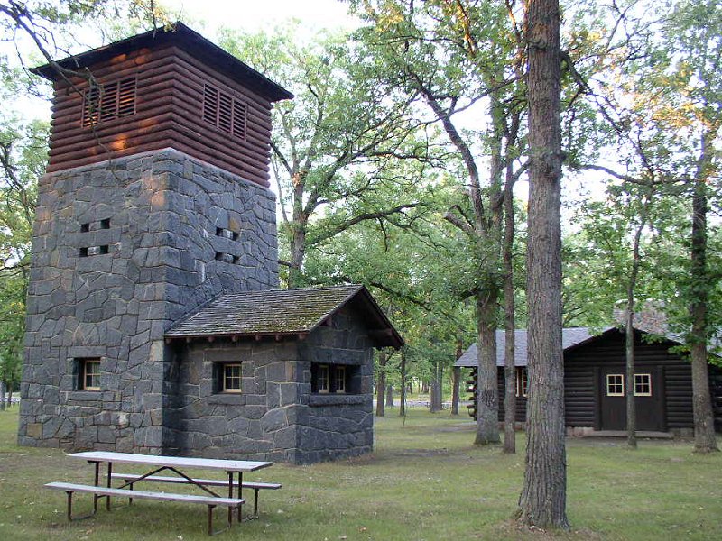
Listed on the National Register of Historic Places in 1989.
One of 15 National Register listings published here for Morrison County · listed in 1989 · category: District.
Sources: the case file at the National Archives · the National Register database, National Park Service
Regional context, not property-specific evidence. The federal wildfire occurrence database lists 203 fires within 5 miles of Charles A. Lindbergh State Park WPA/Rustic Style Historic Resources between 1992 and 2020, burning about 941 acres in total. None started naturally. 27 were recorded as arson. Distance is straight-line from the map coordinates, so a fire counted here may appear on a neighbouring settlement's page as well.
| Reported cause | Fires |
|---|---|
| Debris and open burning | 93 |
| Equipment and vehicle use | 35 |
| Arson/incendiarism | 27 |
| Railroad operations and maintenance | 16 |
| Missing data/not specified/undetermined | 15 |
| Smoking | 9 |
| Recreation and ceremony | 4 |
| Power generation/transmission/distribution | 2 |
| Fireworks | 1 |
| Misuse of fire by a minor | 1 |
The most recent of them, most recent first, with the day each was reported and the service that recorded it.
| Date | Cause | Size | Reported by | Name on the report |
|---|---|---|---|---|
| 8 September 1998 | Railroad operations and maintenance | under an acre | Minnesota Department of Natural Resources | not named |
| 7 September 2013 | Equipment and vehicle use | 1.2 acres | Minnesota Department of Natural Resources | not named |
| 28 September 2012 | Equipment and vehicle use | under an acre | Minnesota Department of Natural Resources | not named |
| 14 September 2012 | Equipment and vehicle use | under an acre | Minnesota Department of Natural Resources | not named |
| 1 September 1996 | Railroad operations and maintenance | under an acre | Minnesota Department of Natural Resources | not named |
| 8 August 2007 | Equipment and vehicle use | under an acre | Minnesota Department of Natural Resources | not named |
| 6 August 2005 | Equipment and vehicle use | under an acre | Minnesota Department of Natural Resources | not named |
| 31 August 2015 | Equipment and vehicle use | under an acre | Minnesota Department of Natural Resources | not named |
Regional context, not property-specific evidence. The federal mineral resources record lists 1 working within 5 miles of Charles A. Lindbergh State Park WPA/Rustic Style Historic Resources: 1 occurrence. None of them still produces. What was taken out: Titanium, Water, Free, Aluminum, Iron, Silica. Distance is straight-line from the map coordinates, so a quarry counted here may appear on a neighbouring settlement's page as well.
| Where | Site | Commodity | Status | Recorded |
|---|---|---|---|---|
| Mississippi River Area Clays | Titanium, Water, Free, Aluminum, Iron, Silica | Occurrence |
Regional context, not property-specific evidence. The National Weather Service names Little Falls, the town this property stands in, in 46 storm reports between 1995 and 2024: 20 thunderstorm wind, 19 hail, 2 flood, 2 heavy rain. No death or injury is recorded in these reports. Each account below is quoted exactly as the forecast office filed it, from the NOAA Storm Events Database, and each date opens the federal record of that event.
| When | Event | Place named | Harm | What the report says |
|---|---|---|---|---|
| May 2022 | Thunderstorm Wind | Little Falls | $75,000 | Significant wind damage occurred to city-owned property of the Little Falls Golf Course. There were 53 trees lost to the storm, along with several large branches. There were also several buildings damage to the local Little Falls Community School District. Dozens of trees were also broken or uprooted in the southeast part of town. A damage survey by the NWS was performed and it appeared to have been downburst damage. |
| June 2001 | Flash Flood | Little Falls | $20,000 | Little Elk River in Randall overflowed. Skunk River in Pierz overflowed and undermined Park Road bridge. Many highways and basements flooded. |
| August 2024 | Thunderstorm Wind | Little Falls | - | Trees down in the Little Falls with a measured wind gust of 65 mph. |
| June 2024 | Thunderstorm Wind | Little Falls | - | A few trees were down, including one on a power line. |
| June 2024 | Thunderstorm Wind | Little Falls | - | Tree down on the 700 block of 6th St NE. Time estimated via radar. |
| June 2022 | Heavy Rain | Little Falls | - | Storm total from overnight thunderstorms 4.00 inches. |
| August 2020 | Thunderstorm Wind | Little Falls | - | A measured wind report from a private weather sensor. |
| September 2019 | Thunderstorm Wind | Little Falls | - | There were numerous reports of downed trees in the Little Falls area. |
| July 2019 | Hail | Little Falls | - | There were reports of hail throughout the county, with the largest hailstone being ping pong ball size in Little Falls. |
| June 2018 | Thunderstorm Wind | Little Falls | - | A tree was blown onto a house in Little Falls. |
| June 2016 | Thunderstorm Wind | Little Falls | - | A tree was blown down across a road in Little Falls. |
| July 2016 | Thunderstorm Wind | Little Falls | - | Several trees were blown down in Little Falls. |
| June 2013 | Heavy Rain | Little Falls | - | Storm total rainfall amount of 3.73 inches was measured near Little Falls. |
| March 2010 | Flood | Little Falls | - | Highway 10 bridge was closed due to an ice jam. |
| July 2008 | Thunderstorm Wind | Little Falls | - | Dozens of trees also reported down in vicinity. |
| August 2007 | Hail | Little Falls | - | Hail covered the ground. |
| August 2007 | Hail | Little Falls | - | Hail covered the ground. |
| September 2007 | Thunderstorm Wind | Little Falls | - | Two trees down in and near spotter residence. Additional trees and power lines down on the west side of town. |
| June 2007 | Hail | Little Falls | - | Heavy rain also reported. |
| July 2006 | Thunderstorm Wind | Little Falls | - | A tree was reported felled in Belle Prairie Township. |
| June 2005 | Thunderstorm Wind | Little Falls | - | Tree limbs were downed in the southwest part of town. |
| August 2005 | Thunderstorm Wind | Little Falls | - | Two hangars, a maintenance garage, and the roof of the terminal building were damaged by winds measured at 78 MPH at the airport in the southeast corner of town. A large tree also fell onto a truck at the airport. In town, Oak trees up to 40 feet tall and several branches were blown down. |
| August 2005 | Hail | Little Falls | - | Penny sized hail falling along Highway 27 stopped traffic. |
| July 2004 | Thunderstorm Wind | Little Falls | - | A tree was downed between two homes on 7th Street SE. |
| September 2004 | Thunderstorm Wind | Little Falls | - | Several trees were downed, including one in Pine Grove Park. |
| June 2001 | Hail | Little Falls | - | This was the last severe report from a series of storms that formed in Douglas County near Rose City, produced a tornado 3 E Long Prairie in Todd County, and moved into Morrison County. |
| July 2001 | Thunderstorm Wind | Little Falls | - | Grove of trees felled. |
| July 2000 | Flood | Little Falls | - | Two to three inches rain in less than two hours caused minor street flooding, with two vehicles stranded. |
| July 2000 | Thunderstorm Wind | Little Falls | - | Trees blown down. |
| July 1999 | Thunderstorm Wind | Little Falls | - | Estimated winds, trees down. |
| July 1999 | Tornado (F0) | Little Falls | - | Large trees down. |
| July 1995 | Thunderstorm Wind | Little Falls | - | Trees down from thunderstorm winds. |
| May 2022 | Hail | Little Falls | - | no account filed |
| May 2022 | Hail | Little Falls | - | no account filed |
| July 2016 | Hail | Little Falls | - | no account filed |
| July 2009 | Hail | Little Falls | - | no account filed |
| July 2008 | Hail | Little Falls | - | no account filed |
| May 2006 | Hail | Little Falls | - | no account filed |
| July 2006 | Hail | Little Falls | - | no account filed |
| September 2002 | Hail | Little Falls | - | no account filed |
| September 2002 | Hail | Little Falls | - | no account filed |
| June 2001 | Funnel Cloud | Little Falls | - | no account filed |
| June 2001 | Hail | Little Falls | - | no account filed |
| July 1999 | Hail | Little Falls | - | no account filed |
| June 1997 | Hail | Little Falls | - | no account filed |
| July 1995 | Hail | Little Falls | - | no account filed |
No historic map-sheet match is published for this property yet. That does not mean no map exists. This record needs a coordinate-quality review before it can be joined to a sheet boundary. Browse the county's mapped places while that work is pending.
Other National Register properties close enough to walk or drive between, ordered by distance from this one. Both positions come from the same geocoding pass that matched these properties to their map sheets.
| Photograph | Property | Distance | Listed |
|---|---|---|---|
 | Charles A. Lindbergh House and Park | 0.1 miles | 1970 |
 | Weyerhaeuser, Charles A., and Musser, Richard Drew, Houses | 1.5 miles | 1985 |
 | Burton-Rosenmeier House | 1.5 miles | 1986 |
 | Northern Pacific Railway Depot | 1.7 miles | 1985 |
 | Little Falls Commercial Historic District | 1.8 miles | 1994 |
 | Morrison County Courthouse | 1.9 miles | 1978 |
| National Archives record | The nomination case file for reference 89001655 in Record Group 79. |
| Morrison County | All 15 listed properties in this county. |