 Block
From the record
One of 20 National Register listings published here for Rock County · listed in 1989 · category: Structure.
Sources: the case file at the National Archives · the National Register database, National Park Service
Listed on the National Register of Historic Places in 1989.
One of 20 National Register listings published here for Rock County · listed in 1989 · category: Structure.
Sources: the case file at the National Archives · the National Register database, National Park Service
Regional context, not property-specific evidence. The federal mineral resources record lists 1 working within 5 miles of Bridge No. L-2315: 1 past producer. None of them still produces. What was taken out: Iron. Distance is straight-line from the map coordinates, so a quarry counted here may appear on a neighbouring settlement's page as well.
| Where | Site | Commodity | Status | Recorded |
|---|---|---|---|---|
| Bonnerud Mine | Iron | Past Producer |
Regional context, not property-specific evidence. The National Weather Service names Luverne, the town this property stands in, in 70 storm reports between 1994 and 2026: 29 hail, 21 thunderstorm wind, 5 tornado, 5 flash flood. No death or injury is recorded in these reports. Each account below is quoted exactly as the forecast office filed it, from the NOAA Storm Events Database, and each date opens the federal record of that event.
| When | Event | Place named | Harm | What the report says |
|---|---|---|---|---|
| June 2014 | Flash Flood | Luverne | $3,000,000 | In the midst of very heavy rain, estimated as much as 7 inches, a dam partially gave way on Blue Mounds Creek at Blue Mounds Lake in Blue Mounds State Park. The dam break drained the lake and flooded roads downstream to the Rock River. |
| August 2004 | Thunderstorm Wind | Luverne | $2,000,000 | Thunderstorm winds blew down part of the roof of a large store, destroyed a hangar, and damaged a small plane inside. The winds also blew down signs including a large gas station sign, blew down the roof of a hardware store shed onto a pickup parked inside and destroyed several storage sheds and other small structures. Parts of roofs of several homes and garages were blown off or damaged. The winds caused widespread tree damage, with falling trees or debris damaging several homes and vehicles, and debris blocking several roads. Power lines and poles were blown down, causing power outages, and several light poles were also blown down. The winds also caused severe crop damage in the area, but the amount of crop damage could not be determined. |
| September 2019 | Flood | Luverne | $50,000 | After excessive two-day rainfall during September 10-12 (9.08 inches near Edgerton and 4.72 inches at Luverne), the Rock River at Luverne (gage site LUVM5) reached the third highest stage on record of 3.94 feet above flood stage on September 13. Numerous county roads were inundated, and the city park in Luverne was under several feet of water. |
| April 2001 | Thunderstorm Wind | Luverne | $50,000 | no account filed |
| July 1998 | Thunderstorm Wind | Luverne | $50,000 | no account filed |
| May 2004 | Tornado (F1) | Luverne | $20,000 | A tornado destroyed a storage shed, silo, and outbuildings on a farm. The tornado also caused shingle and gutter damage to a house on the farm. On another farm, two corn bins were destroyed and a pole barn was damaged. Two large trees were blown down at the second farm, one of the trees damaging the corner of a house when it fell. The tornado was visible from long distances and photographed from several locations. |
| July 2004 | Thunderstorm Wind | Luverne | $20,000 | Thunderstorm winds caused tree damage, with numerous branches broken off. The winds also damaged a storage shed and blew down power lines, causing a power outage. The winds also blew down crops in the area. |
| June 2001 | Thunderstorm Wind | Luverne | $10,000 | Thunderstorm winds blew a large tree onto a small building, destroying the building. |
| July 1998 | Lightning | Luverne | $10,000 | no account filed |
| May 1996 | Tornado (F0) | Luverne | $10,000 | no account filed |
| July 1995 | Thunderstorm Wind | Luverne | $8,000 | Thunderstorm winds of unknown speed blew down a large tree onto a truck. |
| July 2000 | Thunderstorm Wind | Luverne | $5,000 | Thunderstorm winds caused tree damage at Blue Mounds State Park, including several large trees blown down. |
| April 2026 | Hail | Luverne | - | Hail occurred for 5 to 10 minutes, largest briefly up to ping-pong ball size. |
| September 2025 | Funnel Cloud | Luverne | - | A funnel cloud was viewed by several law enforcement officers and storm chasers. |
| June 2024 | Flood | Luverne | - | The Rock River at Luverne rose above flood stage the morning of June 21st, cresting around 3.61 feet above flood stage (13.61 feet) on June 22nd. This crest is in the Moderate Stage. The river then fell below flood stage on the morning of June 24th. For a more comprehensive description of flood damage, please see other entries for Rock County. |
| June 2023 | Thunderstorm Wind | Luverne | - | Thunderstorm winds downed a large tree limb. |
| July 2023 | Thunderstorm Wind | Luverne | - | Thunderstorm wind gusts up to 73 mph were measured by a personal weather station 1 mile north-northeast of Luverne. |
| May 2022 | Thunderstorm Wind | Luverne | - | Thunderstorm winds downed several trees. |
| July 2022 | Flash Flood | Luverne | - | Heavy rainfall produced significant flooding of Highway 75 and Main Street in Luverne. |
| May 2022 | Thunderstorm Wind | Luverne | - | Numerous small tree limbs were downed by thunderstorm winds. |
| July 2020 | Heavy Rain | Luverne | - | Photograph of rain gauge with nearly 5.00 inches was provided. |
| July 2020 | Heavy Rain | Luverne | - | Rainfall report of 3.48 inches from cooperative observer LUVM5. |
| July 2020 | Heavy Rain | Luverne | - | Rainfall amount of 4.90 inches from Blue Mounds State Park office. |
| March 2019 | Flood | Luverne | - | Snow melt and heavy rainfall (measured 1.77 inches near Edgerton and 1.54 inches at Luverne) resulted in flooding of agricultural lands. The Rock River at Luverne (gage site LUVM5) reached a crest 0.47 feet above flood stage on March 21. |
| June 2018 | Flood | Luverne | - | A week of periodic heavy rainfall ending June 26 resulted in a widespread 4 to 8 inches of rainfall, much of which occurred on June 20 and 24. Minor flooding occurred with significant amounts of crop and pasture land inundated as the Rock River at Luverne (gage site LUVM5) crested 1.7 feet above flood stage on June 22. The river dropped below flood stage on June 23. |
| July 2018 | Flood | Luverne | - | Significant amounts of crop and pasture land near the Rock River were impacted by minor flooding as river levels climbed to 0.3 foot above flood stage near Luverne (gage site LUVM5) on July 5. |
| May 2017 | Thunderstorm Wind | Luverne | - | Tree downed. |
| June 2015 | Thunderstorm Wind | Luverne | - | Thunderstorm winds blew down trees. |
| June 2014 | Tornado (EF0) | Luverne | - | A brief tornado caused no reported damage. |
| April 2006 | Flash Flood | Luverne | - | Heavy rainfall of 2 to 4 inches flooded roads and basements as storm sewers backed up. |
| May 2005 | Hail | Luverne | - | Large hail covered the ground. |
| April 2004 | Hail | Luverne | - | Hail covered the ground. |
| May 2004 | Hail | Luverne | - | Large hail damaged vehicles and crops. The amount of damage was unknown. |
| May 2004 | Hail | Luverne | - | Large hail stripped leaves off trees, and caused an unknown amount of crop damage. |
| May 2004 | Hail | Luverne | - | Large hail covered old highway 16 and nearby fields. |
| August 2004 | Flash Flood | Luverne | - | Heavy rain caused flooding of several roads, fields, and other low areas in and near Luverne. |
| August 2002 | Thunderstorm Wind | Luverne | - | Thunderstorm winds caused tree damage, including several branches down. |
| August 2002 | Flash Flood | Luverne | - | Heavy rainfall of up to six inches caused flooding of roads and low areas. The flooding included the area along Spring Creek, with flooding and resulting damage to several holes on a golf course. |
| July 2000 | Thunderstorm Wind | Luverne | - | Thunderstorm winds caused tree damage, including large branches down. |
| July 1995 | Tornado (F0) | Luverne | - | Law enforcement reported a brief tornado touchdown near Interstate 90 south of Luverne. |
| April 1994 | Tornado (F0) | Luverne | - | A tornado touched down briefly southeast of Luverne and damaged six mobile homes. |
| July 1994 | Thunderstorm Wind | Luverne | - | Strong thunderstorm winds blew down several trees and damaged a number of buildings across eastern Rock County |
| June 2014 | Hail | Luverne | - | no account filed |
| June 2013 | Hail | Luverne | - | no account filed |
| June 2013 | Hail | Luverne | - | no account filed |
| May 2012 | Hail | Luverne | - | no account filed |
| August 2012 | Hail | Luverne | - | no account filed |
| August 2012 | Hail | Luverne | - | no account filed |
| August 2012 | Hail | Luverne | - | no account filed |
| August 2011 | Hail | Luverne | - | no account filed |
| August 2011 | Thunderstorm Wind | Luverne | - | no account filed |
| June 2010 | Thunderstorm Wind | Luverne | - | no account filed |
| June 2010 | Thunderstorm Wind | Luverne | - | no account filed |
| July 2008 | Hail | Luverne | - | no account filed |
| June 2005 | Thunderstorm Wind | Luverne | - | no account filed |
| June 2005 | Hail | Luverne | - | no account filed |
| May 2005 | Hail | Luverne | - | no account filed |
| July 2005 | Hail | Luverne | - | no account filed |
| June 2005 | Thunderstorm Wind | Luverne | - | no account filed |
| November 2005 | Hail | Luverne | - | no account filed |
No historic map-sheet match is published for this property yet. That does not mean no map exists. This record needs a coordinate-quality review before it can be joined to a sheet boundary. Browse the county's mapped places while that work is pending.
Other National Register properties close enough to walk or drive between, ordered by distance from this one. Both positions come from the same geocoding pass that matched these properties to their map sheets.
| Photograph | Property | Distance | Listed |
|---|---|---|---|
| Bridge No. L-2316 | 0.2 miles | 1989 | |
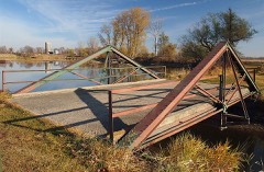 | Bridge No. 1482 | 5.8 miles | 1992 |
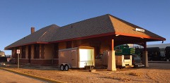 | Omaha Depot | 7.2 miles | 1980 |
 | Palace Theater | 7.4 miles | 1980 |
 | Luverne Carnegie Library | 7.4 miles | 1980 |
 | Rock County Courthouse and Jail | 7.5 miles | 1977 |
| National Archives record | The nomination case file for reference 89001841 in Record Group 79. |
| Rock County | All 20 listed properties in this county. |