BlockBefore
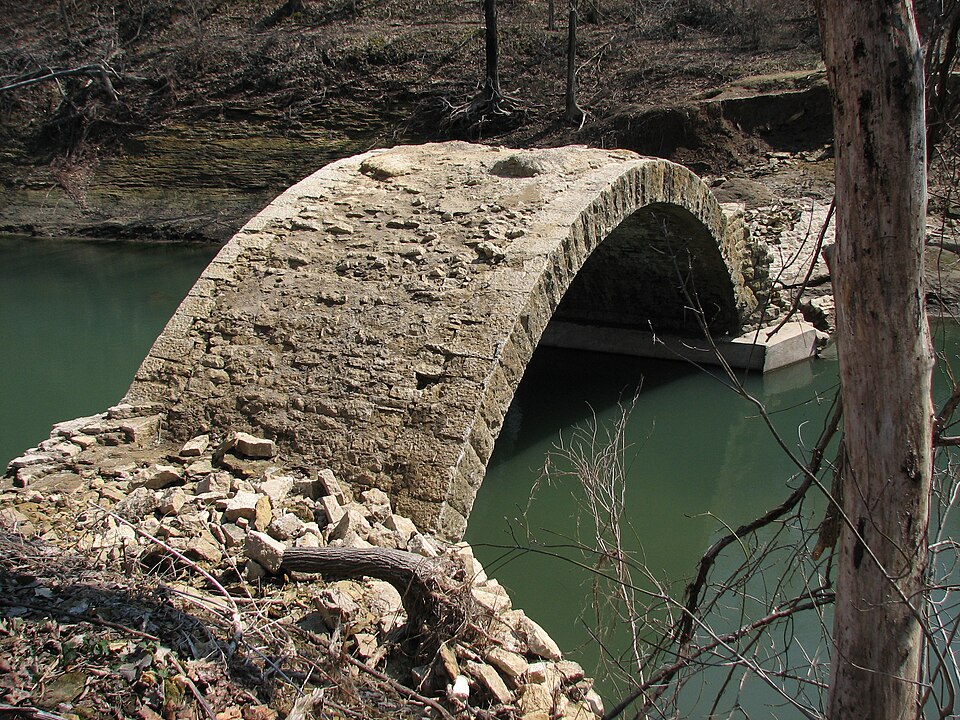
Photograph of Bridge No. L1409
Photograph by Bucienator, CC BY-SA 3.0. Via Wikimedia Commons.

Bridge No. L1409

Listed on the National Register of Historic Places in 1990.

From the record

“L1409, also known as the Garvin Brook Bridge, was a historic stone arch bridge in Hillsdale Township, Minnesota, United States, built in 1895. However it was largely destroyed during the 2007 Midwest flooding, when runoff carried away everything except the arch substructure.”

Wikipedia article Bridge No. L1409, CC BY-SA 4.0.

One of 50 National Register listings published here for Winona County · listed in 1990 · category: Structure.

Sources: the Wikipedia article · the case file at the National Archives · the National Register database, National Park Service

The listing

  • What is counted as historic. The nomination lists 1 structure as contributing to the listing.
  • Address. Twp. Rd. 62 over Garvin Brook, Winona, 55959
  • When was it listed? July 1990
  • Category. structure
  • Also known as. Minnesota Masonry-Arch Highway Bridges MPS
  • Township. Hillsdale township
  • National Register reference number. 90000978 - the number the National Park Service assigned this property when it was listed, and the key its nomination file is catalogued under at the National Archives.

Fires near this property

43 since 1992

Regional context, not property-specific evidence. The federal wildfire occurrence database lists 43 fires within 5 miles of Bridge No. L1409 between 1992 and 2010, burning about 86 acres in total. 1 started naturally. 4 were recorded as arson. Distance is straight-line from the map coordinates, so a fire counted here may appear on a neighbouring settlement's page as well.

Reported cause Fires
Debris and open burning17
Smoking9
Missing data/not specified/undetermined5
Arson/incendiarism4
Equipment and vehicle use3
Recreation and ceremony2
Natural1
Misuse of fire by a minor1
Power generation/transmission/distribution1

The most recent of them, most recent first, with the day each was reported and the service that recorded it.

DateCause SizeReported by Name on the report
15 August 1997Debris and open burningunder an acreMinnesota Department of Natural Resourcesnot named
6 July 1992Smokingunder an acreMinnesota Department of Natural Resourcesnot named
28 June 1997Naturalunder an acreMinnesota Department of Natural Resourcesnot named
26 June 1992Smokingunder an acreMinnesota Department of Natural Resourcesnot named
13 June 1997Missing data/not specified/undetermined1.5 acresWinona District of the Upper Mississippi ComplexGRAFF
1 June 1997Debris and open burningunder an acreMinnesota Department of Natural Resourcesnot named
7 May 2004Debris and open burning4.0 acresMinnesota Department of Natural Resourcesnot named
26 May 2003Smokingunder an acreMinnesota Department of Natural Resourcesnot named

Every fire recorded in Winona County

Mines and quarries near this property

10 of 11 shown

Regional context, not property-specific evidence. The federal mineral resources record lists 11 workings within 5 miles of Bridge No. L1409: 8 producers, 3 occurrences. 8 still produce. What was taken out: Stone, Crushed/Broken, Sand and Gravel, Construction, Limestone, Dimension. Distance is straight-line from the map coordinates, so a quarry counted here may appear on a neighbouring settlement's page as well.

Where SiteCommodity StatusRecorded
Biesanz Winona QuarryLimestone, DimensionProducer
Biesanz Sand & Gravel PitSand and Gravel, ConstructionProducer
Rivers Breeze Gravel DepositSand and Gravel, ConstructionOccurrence
Winona Aggregate Pit & PlantSand and Gravel, ConstructionProducer
Bronk Quarry and MillStone, Crushed/BrokenProducer
Fountain City Dolomite DepositStone, Crushed/BrokenOccurrence
Fountain City Shale DepositStone, Crushed/BrokenOccurrence
Kohner QuarryStone, Crushed/BrokenProducer
Mathy QuarryStone, Crushed/BrokenProducer
Winona Quarry and MillStone, Crushed/BrokenProducer

Every working recorded in Winona County

Storms near this property

60 of 141 shown

Regional context, not property-specific evidence. The National Weather Service names Winona, the town this property stands in, in 141 storm reports between 1993 and 2025: 55 hail, 42 thunderstorm wind, 25 flood, 7 heavy rain. No death or injury is recorded in these reports. Each account below is quoted exactly as the forecast office filed it, from the NOAA Storm Events Database, and each date opens the federal record of that event.

WhenEvent Place namedHarm What the report says
August 2007Flash FloodWinona$12,000,000All drainage areas leading into communities in eastern Winona County experienced tremendous flash flooding. State Highway 43 was washed out just south of Winona. In addition, more than 300 residents were evacuated from their homes in Goodview due to high water. In Minnesota City a railroad bridge was ripped apart by Garvin Brook and a highway bridge through town suffered major damage on each end. Railroad tracks were warped or pushed clear out of position. Major erosion was seen.
June 2020HailWinona$1,800,000Hail ranging in size from 1.25 to 2 inches in diameter moved across the city of Winona causing extensive roof damage to houses and buildings.
August 2007FloodWinona$1,500,000Law enforcement officials reported some roads and bridges washed out or still under water. Whitewater State Park remained closed. In Goodview, extensive damage occurred to homes and apartments due to flood waters. All or portions of highways still closed included Highway 76 from Interstate 90 to Highway 16.
June 1998Thunderstorm WindWinona$400,000no account filed
September 2019Tornado (EF1)Winona$175,000A short-lived tornado moved through Woodlawn Cemetery in Winona. The tornado caused extensive damage to trees and gravestones. The roof of a shed was also damaged.
July 2024FloodWinona$85,000Significant rainfall throughout June pushed the Mississippi River at Winona into flood stage in June and continued into July. The river stage crested during the afternoon on July 2nd in moderate flood stage at 16.14 ft.
August 1998Thunderstorm WindWinona$75,000no account filed
August 1998Thunderstorm WindWinona$55,000no account filed
June 2008FloodWinona$50,000Street flooding was reported in Winona.
May 1998Thunderstorm WindWinona$50,000no account filed
August 1998Thunderstorm WindWinona$40,000no account filed
August 1997Flash FloodWinona$40,000no account filed
August 1998Thunderstorm WindWinona$30,000no account filed
June 1998HailWinona$30,000no account filed
August 1997HailWinona$30,000no account filed
August 2024Flash FloodWinona$25,000The public reported water inside of a parked vehicle on the east side of Winona.
September 2000HailWinona$25,000no account filed
August 1997HailWinona$25,000no account filed
July 2019Flash FloodWinona$22,000Runoff from heavy rain caused mudslides to occur south of Pickwick. The mudslide took down trees and covered County Road 7 between Pickwick and County Road 12. County Road 7 was also covered by floodwaters from Big Trout Creek. A rockslide occurred on Garvin Heights Road in the city of Winona.
May 2019FloodWinona$20,000Flooding along the Mississippi River at Winona that began in March, temporarily ended in early May.
March 2017Thunderstorm WindWinona$20,000A large tree was blown down on a car and partially on a house in the city of Winona.
July 1998Thunderstorm WindWinona$20,000no account filed
August 1997HailWinona$20,000no account filed
October 2013LightningWinona$15,000Lightning struck a power pole causing a line to fall onto 3 buildings. All three buildings then caught on fire.
May 1998Thunderstorm WindWinona$15,000no account filed
July 1998Thunderstorm WindWinona$15,000no account filed
August 1997Thunderstorm WindWinona$15,000no account filed
May 2019FloodWinona$13,000Runoff after a couple of rainfall events pushed the Mississippi River out of its banks again in Winona. The river crested over two feet above the flood stage at 15.13 feet on May 25th. The flooding continued into June.
December 2021Thunderstorm WindWinona$10,000Trees and power poles were snapped off in Winona.
September 2019Thunderstorm WindWinona$10,000Trees and power lines were blown down in Winona.
September 2019Thunderstorm WindWinona$10,000The roof of a restaurant was damaged by high winds.
June 2018Flash FloodWinona$10,000A car was damaged by a rock slide along U.S. Highway 61 near Winona.
April 1997Thunderstorm WindWinona$10,000no account filed
August 2000HailWinona$8,500no account filed
July 2008Thunderstorm WindWinona$8,000Thunderstorm wind gusts blew a tree down on top of a garage in Winona, destroying the garage.
May 1998Thunderstorm WindWinona$8,000no account filed
August 1996Thunderstorm WindWinona$8,000no account filed
June 2000HailWinona$7,000no account filed
June 2001HailWinona$6,000no account filed
July 2021Thunderstorm WindWinona$5,000A large tree was uprooted and fell onto a house in Winona.
September 2019Thunderstorm WindWinona$5,000Numerous trees blown down in Winona. Power outages in Winona, Goodview and Minnesota City affected around 1,200 customers.
July 2018Thunderstorm WindWinona$5,000Part of a barn roof was blown off south of Winona as the outflow from a line of thunderstorms moved across eastern Winona County.
September 2018Thunderstorm WindWinona$5,000Several trees were blown down in Winona.
August 2014Thunderstorm WindWinona$4,000Power lines and some trees were blown down hear Huff Street and U.S. Highway 61 in the city of Winona.
August 2012LightningWinona$3,100A lightning strike produced a 2 square foot hole in the roof of a detached garage. The resulting fire was quickly put out with no other damage occurring to the garage.
April 2021HailWinona$3,000Hail up to 1.5 inches in diameter was reported southeast of Winona.
June 2001HailWinona$3,000no account filed
June 1999Thunderstorm WindWinona$3,000no account filed
August 2005Thunderstorm WindWinona$2,500no account filed
July 2019Thunderstorm WindWinona$2,000Trees were blown down in Winona.
September 2019Thunderstorm WindWinona$2,000Trees were blown down on the campus of Winona State University in Winona.
June 2017Thunderstorm WindWinona$2,000Trees were blown down in Winona.
June 2008Thunderstorm WindWinona$2,000Numerous 12 inch diameter trees were blown down mainly in the city of Winona.
August 2007Thunderstorm WindWinona$2,000Power line down in the western part of the city of Winona.
September 2010Thunderstorm WindWinona$1,500A street light pole and stop lights were blown down in the city of Winona.
July 2010Thunderstorm WindWinona$1,500The emergency manager reported trees down on the west side of the city of Winona.
May 2000HailWinona$1,500no account filed
August 2018LightningWinona$1,000A lightning strike started a tree fire and ruptured a gas line in Winona. The fire burned until the utility company shut the gas off.
July 2011LightningWinona$1,000Lightning struck a house in Winona.

Every storm recorded in Winona County

Map coverage status

No historic map-sheet match is published for this property yet. That does not mean no map exists. This record needs a coordinate-quality review before it can be joined to a sheet boundary. Browse the county's mapped places while that work is pending.

Listed places nearby

6 within 8 miles

Other National Register properties close enough to walk or drive between, ordered by distance from this one. Both positions come from the same geocoding pass that matched these properties to their map sheets.

Photograph PropertyDistance Listed
Trinity Episcopal Church2.1 miles1984
Madison School3.6 miles2012
Jefferson School3.8 miles2012
Winona and St. Peter Engine House3.9 miles1984
Rollingstone Village Hall4.5 miles2021
Church of the Holy Trinity-Catholic4.8 miles1984

Sources for this property

National Archives recordThe nomination case file for reference 90000978 in Record Group 79.
Wikipedia articleCommunity-written account of this property, licensed CC BY-SA.
Winona CountyAll 50 listed properties in this county.

Provenance

  • Listing record. National Park Service National Register of Historic Places, listed-properties dataset, current to 2026-05-22.
  • Map join. Address geocoded through the United States Census geocoder, then tested against the published boundary of every sheet in the USGS Historical Topographic Map Collection.
  • How this page is made. Listing fields come from federal records; map-sheet coverage is a labelled coordinate-to-boundary calculation, not a source-field claim.
  • Wildfire. Short, Karen C. 2022. Spatial wildfire occurrence data for the United States, 1992-2020 [FPA_FOD_20221014]. 6th Edition. Fort Collins, CO: Forest Service Research Data Archive. https://doi.org/10.2737/RDS-2013-0009.6 Collected with United States Government funding and usable without additional permissions or fees.
  • Mines and quarries. USGS Mineral Resources Data System (MRDS) https://mrdata.usgs.gov/mrds/ A work of the United States government, no copyright under 17 U.S.C. 105.
  • Storms. NOAA National Centers for Environmental Information, Storm Events Database https://www.ncei.noaa.gov/stormevents/ A work of the United States government, no copyright under 17 U.S.C. 105. Narratives are quoted verbatim from the National Weather Service report and are not edited or summarised.