 Block
From the record
One of 15 National Register listings published here for Kandiyohi County · listed in 1991 · category: District.
Sources: the case file at the National Archives · the National Register database, National Park Service
Listed on the National Register of Historic Places in 1991.
One of 15 National Register listings published here for Kandiyohi County · listed in 1991 · category: District.
Sources: the case file at the National Archives · the National Register database, National Park Service
Regional context, not property-specific evidence. The federal wildfire occurrence database lists 3 fires within 5 miles of Broman, Andreas, Johanna, Anna and Frank E., Farmstead between 2000 and 2015, burning about 23 acres in total. None started naturally. None was recorded as arson. Distance is straight-line from the map coordinates, so a fire counted here may appear on a neighbouring settlement's page as well.
| Reported cause | Fires |
|---|---|
| Recreation and ceremony | 1 |
| Other causes | 1 |
| Equipment and vehicle use | 1 |
The most recent of them, most recent first, with the day each was reported and the service that recorded it.
| Date | Cause | Size | Reported by | Name on the report |
|---|---|---|---|---|
| 2 July 2013 | Recreation and ceremony | 1.0 acres | Litchfield Wetland Management District | YARMON WF |
| 6 May 2015 | Other causes | 7.0 acres | Litchfield Wetland Management District | YARMON WF |
| 20 October 2000 | Equipment and vehicle use | 15 acres | Minnesota Department of Natural Resources | not named |
Regional context, not property-specific evidence. The federal mineral resources record lists 1 working within 5 miles of Broman, Andreas, Johanna, Anna and Frank E., Farmstead: 1 producer. All of them still produce. What was taken out: Sand and Gravel, Construction. Distance is straight-line from the map coordinates, so a quarry counted here may appear on a neighbouring settlement's page as well.
| Where | Site | Commodity | Status | Recorded |
|---|---|---|---|---|
| Olson Pit No 2 | Sand and Gravel, Construction | Producer |
Regional context, not property-specific evidence. The National Weather Service names Kandiyohi, the town this property stands in, in 16 storm reports between 1993 and 2022: 7 hail, 6 tornado, 2 thunderstorm wind, 1 lightning. No death or injury is recorded in these reports. Each account below is quoted exactly as the forecast office filed it, from the NOAA Storm Events Database, and each date opens the federal record of that event.
| When | Event | Place named | Harm | What the report says |
|---|---|---|---|---|
| June 2012 | Thunderstorm Wind | Kandiyohi | $250,000 | A line of severe straight-line winds, estimated over 75 mph, occurred north of Kandiyohi, then southeast to the city of Atwater. Numerous trees were uprooted, several barns were damaged or destroyed, windows were blown out in several communities, and power was out for several hours. |
| June 2017 | Tornado (EF1) | Kandiyohi | $200,000 | A tornado was associated with a quasi-linear storm complex. It mostly hit trees and crops, but during the latter half of its path, the tornado did move across or just south of a couple metal farm buildings, causing heavy damage. |
| May 2022 | Hail | Kandiyohi | - | There was a social media picture of 3 inch hail. |
| May 2022 | Hail | Kandiyohi | - | There was a social media picture of 3 inch hail. |
| June 2003 | Tornado (F0) | Kandiyohi | - | This was the first of five tornadoes from one supercell in Kandiyohi County, all of which were videotaped by a storm chaser. This first tornado touched down briefly in an open field. |
| June 2003 | Tornado (F0) | Kandiyohi | - | The second of five tornadoes touched down in an open field. |
| June 2003 | Tornado (F0) | Kandiyohi | - | The third tornado in a series also touched down in an open field. A few trees downed. |
| June 2003 | Tornado (F0) | Kandiyohi | - | The fourth tornado was another brief touchdown in an open field. |
| June 2003 | Tornado (F1) | Kandiyohi | - | The fifth and final tornado from the same supercell moved straight north for two miles, then turned and moved from east to west for one mile as it roped out. During its northward trek, it damaged three farmsteads, knocking down sheds, outbuildings and trees. While traveling west, it moved across corn and bean fields. |
| June 2001 | Hail | Kandiyohi | - | This was the last severe report from the mesocyclone that began in Swift County and produced nine tornadoes from the Danvers area to 1 NW Willmar. |
| May 1993 | Thunderstorm Wind | Kandiyohi | - | Several buildings were destroyed by strong downburst winds. |
| May 2022 | Hail | Kandiyohi | - | no account filed |
| June 2017 | Hail | Kandiyohi | - | no account filed |
| July 2003 | Hail | Kandiyohi | - | no account filed |
| May 1996 | Lightning | Kandiyohi | - | no account filed |
| June 1994 | Hail | Kandiyohi | - | no account filed |
No historic map-sheet match is published for this property yet. That does not mean no map exists. This record needs a coordinate-quality review before it can be joined to a sheet boundary. Browse the county's mapped places while that work is pending.
Other National Register properties close enough to walk or drive between, ordered by distance from this one. Both positions come from the same geocoding pass that matched these properties to their map sheets.
| Photograph | Property | Distance | Listed |
|---|---|---|---|
| John Bosch Farmstead | 4.2 miles | 1987 | |
| Willmar Hospital Farm for Inebriates Historic District | 6.8 miles | 1986 | |
| Albert H. and Jennie C. Sperry House | 7.0 miles | 2020 | |
 | Willmar Tribune Building | 7.3 miles | 2007 |
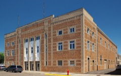 | Willmar Auditorium | 7.4 miles | 1991 |
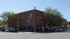 | Lakeland Hotel | 7.4 miles | 2012 |
| National Archives record | The nomination case file for reference 91000098 in Record Group 79. |
| Kandiyohi County | All 15 listed properties in this county. |