 Block
From the record
15 National Register listings published here.
Sources: the National Register database, National Park Service
41 topographic sheets cover 18 settlements here, and 15 properties are on the National Register of Historic Places.
15 National Register listings published here.
Sources: the National Register database, National Park Service
Every property in this county listed on the National Register of Historic Places, with the year it was listed and the federal nomination document.
| Photograph | Property | Type | Listed | Reference |
|---|---|---|---|---|
| John Bosch Farmstead | district | 1987 | 87000620 | |
| Broman, Andreas, Johanna, Anna and Frank E., Farmstead | district | 1991 | 91000098 | |
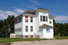 | District No. 55 School | building | 1987 | 87000619 |
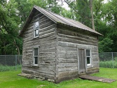 | Lars and Guri Endreson House | building | 1986 | 86001920 |
 | Hotel Atwater | building | 1986 | 86001330 |
 | Lakeland Hotel | building | 2012 | 12000006 |
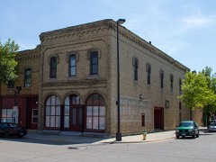 | Larson, A., & Co. Building | building | 1989 | 89000156 |
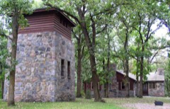 | Sibley State Park CCC/Rustic Style Historic District | district | 1992 | 89001673 |
| Albert H. and Jennie C. Sperry House | building | 2020 | 100004861 | |
| John M. Spicer House | building | 1986 | 86001545 | |
| John M. Spicer Summer House and Farm | building | 1986 | 86002292 | |
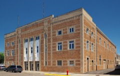 | Willmar Auditorium | building | 1991 | 91000976 |
| Willmar Hospital Farm for Inebriates Historic District | district | 1986 | 86001535 | |
| Willmar Municipal Airport | site | 2013 | 12001174 | |
 | Willmar Tribune Building | building | 2007 | 07000425 |
Every wildfire the federal occurrence database records inside this county: 55 of them, burning about 2,582 acres. 1 started naturally and 8 were recorded as arson. Each settlement page carries the fires within five miles of it.
| Reported cause | Fires |
|---|---|
| Debris and open burning | 15 |
| Missing data/not specified/undetermined | 12 |
| Equipment and vehicle use | 10 |
| Arson/incendiarism | 8 |
| Recreation and ceremony | 6 |
| Other causes | 1 |
| Power generation/transmission/distribution | 1 |
| Natural | 1 |
| Smoking | 1 |
The five largest, by the area the report gives. Four of them were set deliberately.
| Date | Cause | Size | Reported by | Name on the report |
|---|---|---|---|---|
| 16 May 2013 | Recreation and ceremony | 430 acres | Litchfield Wetland Management District | SWAN LAKE WF |
| 11 October 2012 | Equipment and vehicle use | 264 acres | Litchfield Wetland Management District | REGAL MEADOW |
| 21 April 2002 | Arson/incendiarism | 240 acres | Minnesota Department of Natural Resources | not named |
| 17 April 1997 | Arson/incendiarism | 231 acres | Litchfield Wetland Management District | TFLATS 1 |
| 25 April 1999 | Arson/incendiarism | 229 acres | Litchfield Wetland Management District | LOVELL LK. |
| 6 April 2012 | Equipment and vehicle use | 170 acres | Litchfield Wetland Management District | ARCTANDER WF |
| 26 April 2003 | Debris and open burning | 168 acres | Litchfield Wetland Management District | RANDALL WPA |
| 15 May 2020 | Arson/incendiarism | 130 acres | Minnesota Department of Natural Resources | not named |
Every settlement page carries the fires within five miles of it - see the settlement index below.
The NOAA Storm Events Database holds 472 reports for this county, causing 1 death, 8 injuries and about $22,683,060 in recorded property damage. Each settlement page carries the reports that name it.
| Kind of event | Reports |
|---|---|
| Hail | 195 |
| Thunderstorm Wind | 180 |
| Tornado | 56 |
| Funnel Cloud | 13 |
| Heavy Rain | 12 |
| Flash Flood | 9 |
| Lightning | 4 |
| Flood | 2 |
| Strong Wind | 1 |
The most serious of them, by death, then injury, then recorded damage. The accounts are quoted exactly as the forecast office filed them.
| When | Event | Place named | Harm | What the report says |
|---|---|---|---|---|
| May 2022 | Thunderstorm Wind | Blomkest | 1 killed | A grain bin blew over and landed on a man who was about to enter a vehicle. This resulted in a fatality. |
| June 1964 | Tornado (F1) | not stated | 2 hurt, $250,000 | no account filed |
| July 2008 | Tornado (EF3) | Priam | 2 hurt | Three homes were destroyed and eight others were damaged. Barns and sheds were destroyed, along with two businesses, including two turkey barns. At Highway 71 and County Rd. 19 a small trailer was turned on its side, and several farm tractors were turned on their sides. Two minor injuries occurred at a turkey barn 2.5 miles South of Downtown Willmar. |
| June 2001 | Tornado (F1) | Spicer | 2 hurt | Sheds and pole barns down. Church lost part of its roof. Two people were injured when their truck and camper were flung to the edge of a lake. |
| June 1997 | Thunderstorm Wind | Willmar | 1 hurt | Large tree blown onto hood of car. One passenger injured. |
| April 1985 | Thunderstorm Wind | not stated | 1 hurt | no account filed |
| June 2001 | Thunderstorm Wind | Sunburg | $15,000,000 | The mesocyclone which produced its first tornado 9 N Kerkhoven in Swift County intensified dramatically as it neared Spicer. A 5 to 6 mile wide swath of damaging wind blasted an area in a strip from Sunburg to 5 S Sunburg, then intensified dramatically as it neared Spicer and Green Lake. It continued toward the Atwater area, where a seed farm measured 103 knots (119 mph). It then exited Kandiyohi County and went into Meeker County. Hundreds of structures were damaged by the wind, including roofs off some businesses and garages, along with many downed barns, grain bins and outbuildings. Several thousand trees were felled, many onto homes and vehicles. |
| April 1985 | Tornado (F1) | not stated | $2,500,000 | no account filed |
| July 2003 | Tornado (F1) | Pennock | $1,000,000 | A multiple vortex tornado touched down west of Pennock near a turkey farm, which was severely damaged. 200 to 300 turkeys were killed. The tornado then tracked straight east through the city of Pennock, knocking down trees and causing some damage to houses, including partially removing the roof from one home. A large storage building was destroyed in Pennock, as were several sheds and a garage. Just east of Pennock, it took direct aim on a house, lifting off its roof and blowing a shed into a nearby field. Another garage nearby had its roof removed. A strong rear flank downdraft accompanied the tornado, producing wind damage from just east of Pennock to Willmar (see corresponding entry). |
| May 2022 | Thunderstorm Wind | Pennock | $500,000 | A large portion of a turkey barn sheet metal roof was ripped off and blown up to 100 yards away. The flying debris also damaged nearby homes. |
| June 2017 | Thunderstorm Wind | Svea | $500,000 | A large grain bin was blown down near Svea. There were also several turkey barns with roofs blown off. |
| August 2020 | Tornado (EF1) | Spicer | $250,000 | A NWS survey, plus storm chasers video indicated an EF-1 tornado across portions of eastern Kandiyohi County, or the Irving Township area. This tornado destroyed one large shed and heavily damaged another. Drone video indicated the exact track of the tornado as it moved into Meeker County. |
| August 2016 | Flash Flood | Willmar | $250,000 | Several rounds of very heavy rainfall caused significant flooding in the town of Willmar. The first two rounds of heavy rainfall added up to locally 4-6 inches by 9 PM CST. Significant runoff caused some roads to close with basement flooding. |
| June 2012 | Thunderstorm Wind | Kandiyohi | $250,000 | A line of severe straight-line winds, estimated over 75 mph, occurred north of Kandiyohi, then southeast to the city of Atwater. Numerous trees were uprooted, several barns were damaged or destroyed, windows were blown out in several communities, and power was out for several hours. |
| July 2009 | Tornado (EF1) | Spicer | $250,000 | A National Weather Service storm survey, plus visual reports and video, confirmed that a tornado moved through portions of Kandiyohi County near the town of Spicer. Portions of downtown Spicer were damaged, including the partial destruction of the upper level of a home, roof damage to multiple houses, several outbuildings destroyed, and a dozen or more car windows blown out at the local Green Mall parking lot. Maximum wind damage was estimated between 100 to 110 mph. |
| June 1979 | Tornado (F1) | not stated | $250,000 | no account filed |
| June 1979 | Tornado (F1) | not stated | $250,000 | no account filed |
| July 2023 | Thunderstorm Wind | New London | $200,000 | A large machine shed was destroyed. Several dozen large trees and power poles were uprooted or broken. A pontoon was flipped and there was some soffit and shingle damage to a couple houses. |
| June 2017 | Tornado (EF1) | Kandiyohi | $200,000 | A tornado was associated with a quasi-linear storm complex. It mostly hit trees and crops, but during the latter half of its path, the tornado did move across or just south of a couple metal farm buildings, causing heavy damage. |
| April 2001 | Flash Flood | Countywide | $200,000 | no account filed |
| August 2020 | Tornado (EF0) | Spicer | $100,000 | An NWS survey found EF-0 tornado damage along and south of Green Lake around Spicer. The county emergency manager reported portion of a metal roof was blown off near the beginning of the tornado. As it moved northeast, dozens of trees were snapped, and docks along the lake sustained damage. The tornado was documented on several videos, and drone images also provided information on the damage path, including the ending point of the tornado. |
| August 2018 | Tornado (EF0) | Atwater | $100,000 | A NWS storm survey indicated an EF0 Tornado began near Atwater and tracked east for 1.6 miles along Highway 12, and entered Meeker County. Multiple trees and power lines were blown down in the city of Atwater. Some of the trees landed on houses and caused structural damage. |
| September 2017 | Tornado (EF1) | Sunburg | $100,000 | A tornado moved out of Swift County and into northwestern Kandiyohi County. It knocked down trees, damaged crops, and destroyed two machine sheds at a farm. |
| July 2003 | Thunderstorm Wind | Pennock | $100,000 | A strong rear flank downdraft accompanied the Pennock tornado (see corresponding entry). Several trees were felled, bleachers at an athletic complex were destroyed, a grain bin collapsed onto a Bobcat, and a sign at the Kandi Mall was knocked down. |
| July 2023 | Thunderstorm Wind | New London | $50,000 | A spotter with New London Fire and EMS measured 68 mph winds just southeast of Lake Andrew. |
| May 2022 | Thunderstorm Wind | (Bdh)Willmar Municipal Airport | $50,000 | Several large trees were uprooted near the Willmar airport. Some of the trees were snapped at the base along with a destroyed shed. A grain bin was also damaged near the airport. Some sheds in the city of Willmar were also damaged. |
| April 2014 | Lightning | Spicer | $50,000 | An early-morning lightning strike ignited a fire that caused extensive damage to a house overlooking Green Lake near Spicer, Minnesota. The lightning sparked a fire which destroyed a utility room and moved upward to the second story and roof. The interior suffered smoke damage, the electrical system was destroyed, and there was other charring and heat damage. |
| July 2023 | Thunderstorm Wind | Hawick | $30,000 | A large machine shed had part of its roof torn off, and a few nearby trees were also broken. |
| May 1977 | Tornado (F1) | not stated | $25,000 | no account filed |
| September 1975 | Tornado (F1) | not stated | $25,000 | no account filed |
| July 1965 | Tornado (F0) | not stated | $25,000 | no account filed |
| June 1964 | Tornado (F1) | not stated | $25,000 | no account filed |
| May 1959 | Tornado (F1) | not stated | $25,000 | no account filed |
| July 2017 | Lightning | Willmar | $20,000 | Early Wednesday morning, a lightning bolt struck a house in south Willmar. The lightning traveled inside the roof line of the home, which caused the insulation to catch fire. The house suffered considerable smoke damage, along with some water damage from the hoses. pitched roof. |
| July 2001 | Thunderstorm Wind | Willmar | $20,000 | Scattered trees down in a swath that extended to Atwater. Church under construction in Spicer blown down. |
| July 2023 | Thunderstorm Wind | Atwater | $15,000 | Decaying thunderstorm caused a large tree to fall on an unoccupied vehicle in the city of Atwater. The photo was relayed by the emergency manager, and time was estimated from radar. |
| May 2022 | Thunderstorm Wind | Pennock | $10,000 | There were two train cars that were derailed outside of Pennock city limits. |
| May 2022 | Thunderstorm Wind | Prinsburg | $10,000 | Several large tree limbs, and power lines were blown down, including a piece of sheet metal on power lines. |
| July 2010 | Thunderstorm Wind | Pennock | $10,000 | Power lines were reported blown down near Pennock, Minnesota. |
| July 2010 | Thunderstorm Wind | Spicer | $10,000 | Power poles were blown down near Spicer. |
| July 2010 | Thunderstorm Wind | New London | $10,000 | Several power poles were blown down near New London. |
| July 2009 | Thunderstorm Wind | Spicer | $10,000 | A National Weather Service storm survey found straight-line wind damage associated with the rear-flank downdraft of the tornadic thunderstorm that went through Spicer. Localized extensive tree damage was observed where winds were estimated between 90 and 100 mph. |
| May 2016 | Thunderstorm Wind | Blomkest | $5,000 | The emergency manager reported five power poles blown down north of Highway 7, on County Road 44. |
| June 1998 | Thunderstorm Wind | Raymond | $5,000 | Mobile home damaged. |
| June 1969 | Tornado (F0) | not stated | $2,500 | no account filed |
| June 2022 | Thunderstorm Wind | Blomkest | $500 | Several large tree branches were blown down. |
| June 1981 | Tornado (F1) | not stated | $30 | no account filed |
| June 1972 | Tornado (F0) | not stated | $30 | no account filed |
| June 2025 | Thunderstorm Wind | Prinsburg | - | Thunderstorm winds estimated at 65 mph damaged a metal outbuilding near Prinsburg. |
| June 2025 | Thunderstorm Wind | Roseland | - | Thunderstorm winds downed power lines near Roseland. |
| June 2025 | Thunderstorm Wind | Atwater | - | Multiple downed trees on a property west of Lake Elizabeth. |
| July 2025 | Thunderstorm Wind | Sunburg | - | Strong thunderstorm wind gusts caused grain bins to buckle near Sunburg. |
| July 2025 | Thunderstorm Wind | Lake Lillian | - | Trees down in Lake Lillian and Prinsburg. |
| July 2025 | Thunderstorm Wind | New London | - | Thunderstorm wind gusts downed a tree in New London. |
| August 2025 | Thunderstorm Wind | Willmar | - | There were multiple reports of tree damage in the city of Willmar. |
| August 2025 | Heavy Rain | Prinsburg | - | Cocorahs station MN-KD-23 Renville 7.1 N. 72 hour total of 5.11 inches. |
| June 2025 | Heavy Rain | Raymond | - | Report of damage to several roads and many basements with water and sewage. Impacts from heavy rain were mainly across the southern half of Kandiyohi County, including a Trailer Park in the town of Raymond. |
| June 2025 | Thunderstorm Wind | Spicer | - | A thunderstorm wind gust estimated at 60 mph downed two trees in Dovre Township. |
| September 2025 | Funnel Cloud | Blomkest | - | Photo of funnel cloud approximately two miles east of Blomkest submitted via Facebook messenger. |
| June 2025 | Thunderstorm Wind | Lake Lillian | - | Downed tree reported in Big Kandiyohi Lake County Park East. |
The Survey's mineral resources record lists 20 workings inside this county. All of them still produce. Each settlement page carries the workings within five miles of it.
| Commodity | Workings |
|---|---|
| Sand and Gravel, Construction | 20 |
The least common of them first, because a county's hundredth gravel pit says nothing its first ten did not.
| Where | Site | Commodity | Status | Recorded |
|---|---|---|---|---|
| Atwater Pit and Mill | Sand and Gravel, Construction | Producer | ||
| Benson Pit | Sand and Gravel, Construction | Producer | ||
| Central Allied Enterprises Inc | Sand and Gravel, Construction | Producer | ||
| De Cathelineau Pit | Sand and Gravel, Construction | Producer | ||
| Duininck and Gilchrist Pit | Sand and Gravel, Construction | Producer | ||
| Eagle Lake Pit & Mill | Sand and Gravel, Construction | Producer | ||
| Elliot Pit | Sand and Gravel, Construction | Producer | ||
| Goodall Pit No 1 | Sand and Gravel, Construction | Producer | ||
| Goodall Pit No 2 | Sand and Gravel, Construction | Producer | ||
| Hall Pit | Sand and Gravel, Construction | Producer | ||
| Hegstrom Pit | Sand and Gravel, Construction | Producer | ||
| Mcbroom Pit | Sand and Gravel, Construction | Producer | ||
| Messenbrink Pit | Sand and Gravel, Construction | Producer | ||
| Olson Pit | Sand and Gravel, Construction | Producer | ||
| Olson Pit No 2 | Sand and Gravel, Construction | Producer | ||
| Oscar Erickson Pit | Sand and Gravel, Construction | Producer | ||
| Ringo Lake Pit | Sand and Gravel, Construction | Producer | ||
| Ringo Lake Pit and Mill | Sand and Gravel, Construction | Producer | ||
| Tallakson Pit | Sand and Gravel, Construction | Producer | ||
| Willmar Realty Pit | Sand and Gravel, Construction | Producer |
Named settlements recorded in the Geographic Names Information System, each with the topographic sheets covering it. Villages, hamlets and abandoned places alike. Each is shown with the nearest named watercourse or landform and the survey quadrangle it falls on.