
BlockBefore
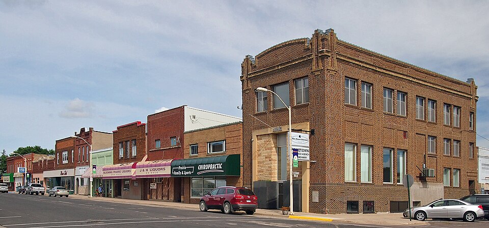
Photograph of Blooming Prairie Commercial Historic District
Photograph by McGhiever, CC BY-SA 4.0. Via Wikimedia Commons.

Blooming Prairie Commercial Historic District

Listed on the National Register of Historic Places in 1994.

From the record

“The Blooming Prairie Commercial Historic District is a designation applied to the historic downtown of Blooming Prairie, Minnesota, United States. It comprises 20 contributing properties built between 1893 and 1932.”

Wikipedia article Blooming Prairie Commercial Historic District, CC BY-SA 4.0.

One of 13 National Register listings published here for Steele County · listed in 1994 · category: District.

Sources: the Wikipedia article · the case file at the National Archives · the National Register database, National Park Service

The listing

Mines and quarries near this property

1 within 5 miles

Regional context, not property-specific evidence. The federal mineral resources record lists 1 working within 5 miles of Blooming Prairie Commercial Historic District: 1 producer. All of them still produce. What was taken out: Sand and Gravel, Construction. Distance is straight-line from the map coordinates, so a quarry counted here may appear on a neighbouring settlement's page as well.

Where SiteCommodity StatusRecorded
Wrander Pit & MillSand and Gravel, ConstructionProducer

Every working recorded in Steele County

Storms near this property

23 since 1997

Regional context, not property-specific evidence. The National Weather Service names Blooming Prairie, the town this property stands in, in 23 storm reports between 1997 and 2025: 10 hail, 5 tornado, 3 thunderstorm wind, 2 flood. The reports record 1 injury. Each account below is quoted exactly as the forecast office filed it, from the NOAA Storm Events Database, and each date opens the federal record of that event.

WhenEvent Place namedHarm What the report says
June 2010Tornado (EF2)Blooming Prairie1 hurtThis EF-2 tornado touched down and tracked east-northeast, and soon crossed the path of the Blooming Prairie EF-3 that had moved north-northeast about 10 minutes earlier. A manufactured home was obliterated by the EF-2. A woman inside the home was blown about 20 feet, but was found under debris, rescued by law enforcement, and survived. The tornado continued moving east-northeast, and several outbuildings were destroyed, along with many broken trees. The tornado continued into Dodge County.
December 2021Tornado (EF0)Blooming Prairie$105,000A narrow path of mostly tree damage was found just to the west of SE 89th Ave. An irrigation system was overturned, some farm outbuildings were damaged, and a small shed was tossed.
September 2025HailBlooming Prairie-Golf ball size hail on Hwy 30 west of Blooming Prairie.
July 2011Flash FloodBlooming Prairie-The Blooming Prairie park area was flooded due to excessive rainfall.
June 2010Tornado (EF3)Blooming Prairie-This tornado developed just north of the Steele/Freeborn County line, shortly after the dissipation in Freeborn County of the Newry tornado. This new tornado moved northeast, and initially, occasional trees were broken. Damage intensified somewhat when it hit a farm on State Highway 30 just west of Blooming Prairie. The tornado continued moving northeast, decimating crops. Some bean fields were scoured in spots. It intensified significantly to EF-3 2.5 miles northwest of Blooming Prairie, where a house was leveled, trees were snapped, and large portions of bark were removed. A pickup truck was lofted about 50 feet into the basement of the house. Several other houses sustained minor damage. The tornado dissipated just west of Highway 218 and 123rd Street. Video recorded by law enforcement and chasers.
June 2010Tornado (EF0)Blooming Prairie-This tornado moved north-northeast and caused minor damage to outbuildings and broke several dozen trees. It exited Steele County about 3/4 mile south of Steele County Road 26 and continued into Dodge County.
May 2009Heavy RainBlooming Prairie-Local law enforcement officials measured 3.50 inches of rain from several periods of heavy rainfall during the late morning and early afternoon of May 6th.
June 2009HailBlooming Prairie-The public observed several hail reports including golf ball and nickel size.
June 2009HailBlooming Prairie-The local media relayed a large hail report west of Blooming Prairie.
July 2008Thunderstorm WindBlooming Prairie-Small tree downed, many branches and other debris on lawns.
July 2002Flash FloodBlooming Prairie-Several streets blocked by high water.
July 2000FloodBlooming Prairie-Estimated 3-4 inches of rain fell during period. Minor street flooding, several homes incurred minor basement flooding.
August 1999FloodBlooming Prairie-Some streets in southwest portion of town under knee deep water. No basements flooded or damages reported.
July 1997Thunderstorm WindBlooming Prairie-Repair shop toppled by high winds. Several trees uprooted. Estimated windspeed.
July 2024HailBlooming Prairie-no account filed
October 2023HailBlooming Prairie-no account filed
September 2010HailBlooming Prairie-no account filed
May 2002HailBlooming Prairie-no account filed
July 2002HailBlooming Prairie-no account filed
June 1999Thunderstorm WindBlooming Prairie-no account filed
March 1998HailBlooming Prairie-no account filed
June 1998HailBlooming Prairie-no account filed
July 1997Tornado (F0)Blooming Prairie-no account filed

Every storm recorded in Steele County

Map coverage status

No historic map-sheet match is published for this property yet. That does not mean no map exists. This record needs a coordinate-quality review before it can be joined to a sheet boundary. Browse the county's mapped places while that work is pending.

Sources for this property

National Archives recordThe nomination case file for reference 94000832 in Record Group 79.
Wikipedia articleCommunity-written account of this property, licensed CC BY-SA.
Steele CountyAll 13 listed properties in this county.

Provenance

  • Listing record. National Park Service National Register of Historic Places, listed-properties dataset, current to 2026-05-22.
  • Map join. Address geocoded through the United States Census geocoder, then tested against the published boundary of every sheet in the USGS Historical Topographic Map Collection.
  • How this page is made. Listing fields come from federal records; map-sheet coverage is a labelled coordinate-to-boundary calculation, not a source-field claim.
  • Mines and quarries. USGS Mineral Resources Data System (MRDS) https://mrdata.usgs.gov/mrds/ A work of the United States government, no copyright under 17 U.S.C. 105.
  • Storms. NOAA National Centers for Environmental Information, Storm Events Database https://www.ncei.noaa.gov/stormevents/ A work of the United States government, no copyright under 17 U.S.C. 105. Narratives are quoted verbatim from the National Weather Service report and are not edited or summarised.