 Block
From the record
13 National Register listings published here, 1 of them a National Historic Landmark.
Sources: the county history on the Internet Archive · the National Register database, National Park Service
31 topographic sheets cover 21 settlements here, and 13 properties are on the National Register of Historic Places.
13 National Register listings published here, 1 of them a National Historic Landmark.
Sources: the county history on the Internet Archive · the National Register database, National Park Service
Every property in this county listed on the National Register of Historic Places, with the year it was listed and the federal nomination document.
| Photograph | Property | Type | Listed | Reference |
|---|---|---|---|---|
| Ezra Abbott House | building | 1975 | 75001029 | |
 | Dr. John H. Adair House | building | 1986 | 86001406 |
 | Administration Building-Minnesota State Public School For Dependent and Neglected Children | building | 1975 | 75001030 |
 | Blooming Prairie Commercial Historic District | district | 1994 | 94000832 |
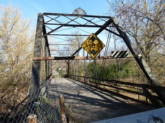 | Bridge No. L-5573 | structure | 1997 | 96001613 |
| Minnesota State Public School for Dependent and Neglected Children | district | 2010 | 10001089 | |
 | National Farmers' Bank | building | 1971 | 71000441 |
 | Owatonna City and Firemen's Hall | building | 1997 | 97000019 |
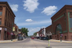 | Owatonna Commercial Historic District | district | 2015 | 14001237 |
| Owatonna Free Public Library | building | 1976 | 76001075 | |
 | Pillsbury Academy Campus Historic District | district | 2021 | 86003680 |
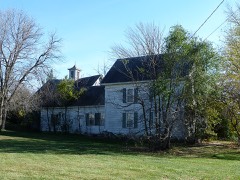 | Daniel S. Piper House | building | 1975 | 75001028 |
| Steele County Courthouse | building | 1978 | 78001565 |
Every wildfire the federal occurrence database records inside this county: 4 of them, burning about 85 acres. None started naturally and none was recorded as arson. Each settlement page carries the fires within five miles of it.
| Reported cause | Fires |
|---|---|
| Missing data/not specified/undetermined | 2 |
| Debris and open burning | 1 |
| Equipment and vehicle use | 1 |
The five largest, by the area the report gives. None of them was recorded as arson.
| Date | Cause | Size | Reported by | Name on the report |
|---|---|---|---|---|
| 21 May 2015 | Debris and open burning | 35 acres | Minnesota Valley National Wildlife Refuge | STRAIGHT CREEK |
| 8 October 2012 | Missing data/not specified/undetermined | 27 acres | Minnesota Department of Natural Resources | not named |
| 23 April 2018 | Missing data/not specified/undetermined | 22 acres | Minnesota Valley National Wildlife Refuge | STRAIGHT CREEK |
| 1 November 2012 | Equipment and vehicle use | 1.0 acres | Minnesota Valley National Wildlife Refuge | LINCOLN |
Every settlement page carries the fires within five miles of it - see the settlement index below.
The NOAA Storm Events Database holds 238 reports for this county, causing no deaths, 1 injury and about $96,274,500 in recorded property damage. Each settlement page carries the reports that name it.
| Kind of event | Reports |
|---|---|
| Thunderstorm Wind | 86 |
| Hail | 80 |
| Tornado | 28 |
| Flash Flood | 19 |
| Heavy Rain | 11 |
| Funnel Cloud | 8 |
| Flood | 5 |
| Lightning | 1 |
The most serious of them, by death, then injury, then recorded damage. The accounts are quoted exactly as the forecast office filed them.
| When | Event | Place named | Harm | What the report says |
|---|---|---|---|---|
| June 2010 | Tornado (EF2) | Blooming Prairie | 1 hurt | This EF-2 tornado touched down and tracked east-northeast, and soon crossed the path of the Blooming Prairie EF-3 that had moved north-northeast about 10 minutes earlier. A manufactured home was obliterated by the EF-2. A woman inside the home was blown about 20 feet, but was found under debris, rescued by law enforcement, and survived. The tornado continued moving east-northeast, and several outbuildings were destroyed, along with many broken trees. The tornado continued into Dodge County. |
| September 2010 | Flood | Ellendale | $28,400,000 | Numerous roads were closed due to excessive rainfall that fell on September 22nd and 23th. The major areal flooding didn't recede until late Saturday when most of the small streams and creeks had crested and only mainstem rivers remained flooded. Residents in Owatonna, Minnesota, were fighting to save their homes along the flooded Maple Creek. 70 homes were evacuated in Owatonna due to the rising flood waters. Friday morning was the first time that I-35 was closed due to flood waters south of Owatonna. It re-opened during the afternoon as waters started to recede. |
| April 1967 | Tornado (F1) | not stated | $25,000,000 | no account filed |
| April 1967 | Tornado (F4) | not stated | $25,000,000 | no account filed |
| May 1996 | Thunderstorm Wind | Owatonna | $5,000,000 | no account filed |
| October 2007 | Flash Flood | Owatonna | $3,000,000 | Three to five inches of rain fell over Owatonna, resulting in flooding of roads, homes and businesses. A city storm sewer also backed up, causing basements to flood in about 40 homes. This event began September 30, 2007 at 2200 CST (see September 2007 Storm Data). |
| August 2007 | Flash Flood | Owatonna | $2,500,000 | A Presidential Disaster Declaration was signed for Steele County in the wake of major flooding and damage. Large areas of Owatonna were reported under two to three feet of water. Water completely covered a few roads, and was above car doors in some areas. Maple Creek at Dartt's Park was reported three times as wide as normal, and spread out into the parking lot. Some basement walls were reported to have collapsed. Two hotels in Owatonna were evacuated. The Steele County emergency manager reported 274 homes and 8 businesses were damaged. Seven homes were considered destroyed. The cooperative observer in Owatonna measured 6.47 inches as of 0700 CST August 19. Some information provided by the Owatonna People's Press newspaper. |
| June 1984 | Tornado (F1) | not stated | $2,500,000 | no account filed |
| June 2014 | Flood | Owatonna Arpt | $2,400,000 | Flood waters from the Straight River impacted businesses in Owatonna. |
| June 2006 | Lightning | Havana | $1,000,000 | Church burned to the ground after lighting hit. One fire fighter was injured while fighting the fire. |
| June 2006 | Flash Flood | Owatonna | $500,000 | Rainfall was reported to vary from 4.4 to 6.3 inches over a narrow area of Steele County. Significant localized flooding occurred, most of which was contained in the industrial park on the western edge of Owatonna. Several of the local factories had flooding in their parking lots. Railroad tracks washed out on North Street. The Microtel hotel, located in this area, had approximately 35 cars submerged in 3 to 4 feet of water. One hundred and eighty people were evacuated from 63 rooms of the hotel by Emergency Services. Some guests of the hotel reported they had water up to their knees in the lower level rooms. Owatonna fire chief Mike Johnson mentioned that 15 homes, mostly in the southeast section of Owatonna had flooding in their basements. Some of these residents reported water up to five feet deep. The over one half million dollar damage estimate included the damage at the hotel plus the flooded vehicles. Information provided by county officials. A large area of mud washed over Highway 14. Interstate 35 was closed at Owatonna. The Red Cross opened an emergency shelter at the Owatonna High School. Some information provided by Faribault Daily News newspaper. |
| May 1982 | Tornado (F3) | not stated | $250,000 | no account filed |
| May 1982 | Tornado (F3) | not stated | $250,000 | no account filed |
| May 1962 | Tornado (F1) | not stated | $250,000 | no account filed |
| December 2021 | Tornado (EF0) | Blooming Prairie | $105,000 | A narrow path of mostly tree damage was found just to the west of SE 89th Ave. An irrigation system was overturned, some farm outbuildings were damaged, and a small shed was tossed. |
| August 2010 | Thunderstorm Wind | Ellendale | $50,000 | A roof was blown off a grainery and a large tree was uprooted west of Ellendale, Minnesota. |
| July 1984 | Tornado (F1) | not stated | $25,000 | no account filed |
| May 1968 | Tornado (F1) | not stated | $25,000 | no account filed |
| June 2001 | Thunderstorm Wind | Owatonna | $10,000 | Roof partially torn off of two businesses. Sheds torn down along with numberous trees. |
| September 2010 | Thunderstorm Wind | Owatonna | $5,000 | Several trees and power lines were blown down in Owatonna, Minnesota. |
| July 1973 | Tornado (F0) | not stated | $2,500 | no account filed |
| August 2019 | Tornado (EF0) | Lemond | $1,000 | Multiple storms chasers, spotters and citizens filmed and photographed this tornado. It mostly moved across fields, and there was minor damage to one soybean field. It blew a portable hoop barn across a field. There was a two mile gap in the middle of its path where it did not appear to be in contact with the ground, but video and pictures show the parent funnel cloud remained consistently evident. |
| May 1994 | Hail | Owatonna | $500 | A severe thunderstorm produced dime-size hail outside of Owatonna. Damaging thunderstorms winds broke several large tree limbs, destroyed numberous hay bales, and toppled mailboxes and posts. |
| May 1994 | Thunderstorm Wind | not stated | $500 | A severe thunderstorm produced dime-size hail outside of Owatonna. Damaging thunderstorms winds broke several large tree limbs, destroyed numberous hay bales, and toppled mailboxes and posts. |
| April 2025 | Hail | Steele Center | - | Measurement provided via social media. |
| April 2025 | Hail | Owatonna | - | Hail measurement provided via phone. |
| August 2025 | Flash Flood | Owatonna | - | The Emergency Manager reported that Hoffman Drive in Owatonna had emergency barricading in place due to water over the road Saturday night. The water had since receded by Sunday morning. |
| August 2025 | Flash Flood | Ellendale | - | The city of Ellendale conducted emergency pumping for their sewer treatment plant over night Saturday into Sunday. One house was barricaded with sandbags due to rising flood waters. |
| August 2025 | Heavy Rain | Ellendale | - | Cocorahs station MN-SE-3 Ellendale 0.3 SW. 72 hour storm total of 5.31 inches. |
| September 2025 | Hail | Bixby | - | Report of a large amount of hail, the largest around quarter sized. |
| September 2025 | Hail | Blooming Prairie | - | Golf ball size hail on Hwy 30 west of Blooming Prairie. |
| May 2024 | Thunderstorm Wind | Steele Center | - | Several trees were downed along County Road 3. |
| September 2024 | Hail | Owatonna | - | A picture on X showed 1 inch hail in Owatonna. |
| June 2024 | Heavy Rain | Bixby | - | A total of 3 to 5 inches of rain fell from multiple rounds of thunderstorms. CoCoRaHS observers measured 4.07 inches near Owatonna. |
| June 2024 | Flash Flood | Owatonna | - | Maple Creek overflowed and flooded roads in and around Mineral Springs Park. |
| June 2024 | Funnel Cloud | Medford | - | A video was provided showing a brief funnel cloud north of Medford. It was not possible to determine if there was any ground contact. |
| May 2022 | Heavy Rain | Owatonna | - | Rainfall was measured at 1.7 inches. Some minor street flooding occurred in Owatonna. |
| June 2022 | Flash Flood | Owatonna | - | Very heavy rainfall occurred in a short period of time in the city of Owatonna. There were a few streets that had water covering the roadway and were impassable at one point. These roads included the intersection of Elm and Main Street, and Rose and Elm Street on the east side of town. |
| July 2022 | Thunderstorm Wind | Bixby | - | A barn was destroyed, and an outbuilding roof collapsed. |
| May 2021 | Funnel Cloud | Owatonna | - | Numerous videos, including some from trained spotters, showed a funnel cloud west of Owatonna. Toward the end, it became rope-like and then dissipated. None of the videos were close-up, and no debris cloud was ever noted, so ground contact contact could not be confirmed by video. Two surveys by local officials and the NWS revealed no damage anywhere. Therefore this has been recorded as a funnel cloud. Videos showed another funnel cloud close to this one, and a separate entry has been made for that funnel. |
| May 2021 | Funnel Cloud | Owatonna | - | Numerous videos, including some from trained spotters and a MNDOT traffic camera, showed a funnel cloud west of Owatonna. None of the videos were close-up, and no debris cloud was ever noted, so ground contact contact could not be confirmed by video. Two surveys by local officials and the NWS revealed no damage anywhere. Therefore this has been recorded as a funnel cloud. Videos showed another funnel cloud (that was rope-like) close to this one, and a separate entry has been made for that funnel. |
| May 2021 | Funnel Cloud | Meriden | - | A storm chaser took video of a brief funnel cloud. It might have made ground contact but it was not possible to tell from the video, nor was there any damage noted. Therefore this has been recorded as a funnel cloud. |
| May 2021 | Tornado (EF0) | Medford | - | Two different trained spotters took video of a tornado that made ground contact in far northern Steele County, where about a dozen trees were broken per a NWS damage survey. It tracked north and moved into Rice County. One of the videos showed this tornado was the larger tornado, with another narrow tornado to its east that had characteristics similar to that of a satellite tornado. |
| December 2021 | Thunderstorm Wind | Steele Center | - | A highway sign and an electronic message sign along Interstate 35 were blown down. Just to the southwest, new power poles were noted to have been erected. Damage was too scant to determine whether this had been from a tornado. |
| August 2020 | Hail | Merton | - | A photograph of the hail was posted to a Skywarn group social media page. |
| June 2019 | Tornado (EF0) | Owatonna | - | The Steele County Sheriff filmed a brief landspout tornado over an open field. |
| August 2019 | Funnel Cloud | Lemond | - | A funnel cloud was observed near Lemond. |
| September 2019 | Thunderstorm Wind | Hope | - | A Minnesota Department of Transportation wind sensor measured a wind gust of 66 mph. |
| July 2019 | Flash Flood | Owatonna Arpt | - | Local law enforcement officials barricaded numerous roads in the Owatonna area due to high water. |
| July 2019 | Thunderstorm Wind | Owatonna | - | A tree was uprooted at the Owatonna country club. |
| July 2019 | Thunderstorm Wind | Ellendale | - | A large tree was snapped at its base in Ellendale. |
| September 2018 | Tornado (EF1) | Meriden | - | A NWS storm survey, plus areal footage of drone and satellite data, concluded that an EF1 tornado started west of Owatonna, and tracked 6.5 miles across the southern and eastern portions of the town, before lifting east of the Brooktree Golf Course. The damage was consistent with EF1 damage with maximum wind speeds of 90 mph and a width of 300 yards. An outbuilding and silo were damaged near the start of the tornado track, with numerous large trees uprooted or blown down in the city of Owatonna. In addition to the tornado damage, severe straight-line winds from inflow of the tornado caused numerous large blown down trees and power poles on the south side of the track. |
| September 2018 | Tornado (EF1) | Meriden | - | This is the continued tornado track from the Waseca County tornado that moved an additional 7.2 miles through northwest Steele County. A storm survey, and high resolution satellite imagery indicated the tornado tracked mainly through corn and soy bean fields, and occasionally damaged a few sheds and outbuildings southwest of Medford. The worst damage was to a silo and grain bin which were destroyed by the tornado. This damage was consistent with EF1 damage with maximum wind speeds of 100 mph and a width of 350 yards. |
| August 2018 | Thunderstorm Wind | Ellendale | - | Large tree limbs were blown down in the town of Ellendale. |
| August 2017 | Thunderstorm Wind | Owatonna | - | The local emergency manager reported several trees blown down around Owatonna. |
| May 2017 | Hail | Hope | - | Several reports of large hail occurred in Steele County between the southwest part of Owatonna, northeast to north of the Rice Lake State Park. The largest hail stone was golf ball size. |
| June 2017 | Thunderstorm Wind | Medford | - | A large tree was blown down on Highway 45 in Steele County. |
| June 2017 | Thunderstorm Wind | Lemond | - | A barn roof was lofted due to severe winds. It was misplaced several feet from the original location of the barn. |
| September 2017 | Thunderstorm Wind | Owatonna | - | Several power poles were blown down in the city of Owatonna. |
| September 2017 | Thunderstorm Wind | Owatonna | - | Several trees, up to 24 inches in diameter, were uprooted at the Brooktree Golf Course in Owatonna. |
The Survey's mineral resources record lists 6 workings inside this county. 5 still produce and 1 is closed or unrecorded. Each settlement page carries the workings within five miles of it.
| Commodity | Workings |
|---|---|
| Sand and Gravel, Construction | 4 |
| Stone, Crushed/Broken | 2 |
The least common of them first, because a county's hundredth gravel pit says nothing its first ten did not.
| Where | Site | Commodity | Status | Recorded |
|---|---|---|---|---|
| Fretham Quarry | Stone, Crushed/Broken | Unknown | ||
| Lundin Cashman Quarry | Stone, Crushed/Broken | Producer | ||
| Concrete Materials Pit #1 | Sand and Gravel, Construction | Producer | ||
| Jones Pit | Sand and Gravel, Construction | Producer | ||
| Schultz Pit & Mill | Sand and Gravel, Construction | Producer | ||
| Wrander Pit & Mill | Sand and Gravel, Construction | Producer |
Geographical and Statistical History of Steele County from Its Earliest Settlement to the Present Time. Embracing Leading Incidents of Pioneer Life, Names of Early Settlers ... &c devotes a chapter to each township: its boundaries and streams, who settled it and when, the mills, the schools and the churches. All 9 are reproduced here in full. Each row shows the township's own shape and where it lies in the county, drawn from the Census Bureau's boundary. Which settlements belong to which township is computed from that same boundary, not taken from the book.
| Shape and position in the county | Township | Settlements in it | Length | Sections |
|---|---|---|---|---|
| Aurora Township | Bixby, Pratt | 1,150 words | 1 | |
| Deerfield Township | Deerfield | 723 words | 0 | |
| Lemond Township | Lemond | 332 words | 0 | |
| Medford City | Medford | 2,588 words | 1 | |
| Meriden Township | Meriden | 354 words | 0 | |
| Merton Township | Merton, Moland, Rice Lake | 1,147 words | 1 | |
| Owatonna City | Clinton Falls, Owatonna | 2,867 words | 2 | |
| Somerset Township | Hope, Litomysl, River Point, Saco, Steele Center | 1,140 words | 0 | |
| Summit Township | Summit | 729 words | 0 |
One book written about this county, cut here where the book itself is cut, at its printed chapters: 1 chapter in all. Every chapter is public domain, machine-read from the scan and reproduced complete. A chapter already given under one of the county's towns is not repeated in this list.
| Chapter | Length |
|---|---|
| The whole text | 25,520 words in 2 parts |
Named settlements recorded in the Geographic Names Information System, each with the topographic sheets covering it. Villages, hamlets and abandoned places alike. Each is shown with the nearest named watercourse or landform and the survey quadrangle it falls on.
Owatonna city · 55060 · On Crane Creek · Medford East quadrangle
9 sheets, 1953 to 1985