 Block
From the record
One of 10 National Register listings published here for Meeker County · listed in 1997 · category: Building.
Sources: the case file at the National Archives · the National Register database, National Park Service
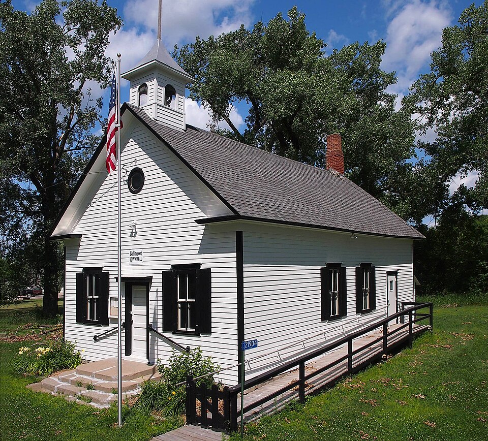
Listed on the National Register of Historic Places in 1997.
One of 10 National Register listings published here for Meeker County · listed in 1997 · category: Building.
Sources: the case file at the National Archives · the National Register database, National Park Service
Regional context, not property-specific evidence. The National Weather Service names Dassel, the town this property stands in, in 53 storm reports between 1993 and 2025: 36 hail, 15 thunderstorm wind, 2 tornado. The reports record 1 injury. Each account below is quoted exactly as the forecast office filed it, from the NOAA Storm Events Database, and each date opens the federal record of that event.
| When | Event | Place named | Harm | What the report says |
|---|---|---|---|---|
| July 2011 | Hail | Dassel | 1 hurt, $500 | In addition, a driver was injured when hail the size of a baseball hit his vehicle's windshield. |
| September 2005 | Hail | Dassel | $800,000 | Hail dented cars, along with roofs and siding of many houses. Some windows broken. Property damage total is for the Dassel area on 9-21-05. |
| July 2008 | Tornado (EF0) | Dassel | $200,000 | Damage survey team reported downed trees in Meeker County. The tornado continued into Wright County, where a roof was ripped off a home and some sheds were destroyed. |
| August 2023 | Hail | Dassel | $100,000 | A photo of hail next to a ruler measured 3.75 inches with the largest stone near Hwy 15. There was damage to the siding on the west side of the house. |
| May 1998 | Thunderstorm Wind | Dassel | $100,000 | Semitrailer blown off highway 12. Estimated windspeed. |
| May 2022 | Thunderstorm Wind | Dassel | $25,000 | A large shed was damaged, including a tree that blew down on a vehicle south of Dassel. |
| July 2003 | Thunderstorm Wind | Dassel | $10,000 | 70 foot HAM radio tower toppled. |
| July 2011 | Thunderstorm Wind | Dassel | $5,000 | A few large trees and power lines were blown down in Dassel. |
| June 2025 | Hail | Dassel | - | Multiple reports of quarter sized hail south of Dassel. |
| August 2024 | Thunderstorm Wind | Dassel | - | Delayed report, time estimated from radar. Tree down across road. |
| August 2023 | Hail | Dassel | - | A picture of hail next to a ruler on social media showed hail slightly larger than 3 inches. |
| July 2023 | Hail | Dassel | - | Golfball size hail was reported 2 miles north of Dassel via social media. |
| July 2015 | Thunderstorm Wind | Dassel | - | A tree was blown across a road north of Dassel. |
| August 2013 | Thunderstorm Wind | Dassel | - | A few trees were blown down near Dassel. |
| June 2007 | Hail | Dassel | - | Small branches felled as well. |
| September 2007 | Thunderstorm Wind | Dassel | - | Trees toppled. |
| September 2005 | Hail | Dassel | - | Dime sized hail was reported on the west side of Lake Jennie. |
| September 2005 | Hail | Dassel | - | A law enforcement officer parked on 183rd Street reported that golf ball sized hail fell for 14 minutes. |
| September 2005 | Hail | Dassel | - | Quarter sized hail was reported 1 mile north of Lamson. |
| May 2004 | Hail | Dassel | - | The time was estimated. |
| June 2003 | Thunderstorm Wind | Dassel | - | Several six inch diameter branches down. |
| June 2002 | Thunderstorm Wind | Dassel | - | Tree down. |
| May 2002 | Thunderstorm Wind | Dassel | - | Eighty foot HAM radio tower downed. Few shingles off house. Large tree toppled. Trained observer watched downburst as it approached. |
| September 2002 | Hail | Dassel | - | Hailed on and off for 30 minutes. |
| July 1997 | Tornado (F0) | Dassel | - | Tree blown onto house. Barn damaged. |
| August 2025 | Hail | Dassel | - | no account filed |
| March 2017 | Hail | Dassel | - | no account filed |
| June 2017 | Thunderstorm Wind | Dassel | - | no account filed |
| May 2015 | Hail | Dassel | - | no account filed |
| August 2013 | Hail | Dassel | - | no account filed |
| August 2012 | Hail | Dassel | - | no account filed |
| July 2011 | Hail | Dassel | - | no account filed |
| July 2011 | Hail | Dassel | - | no account filed |
| July 2011 | Hail | Dassel | - | no account filed |
| May 2008 | Hail | Dassel | - | no account filed |
| June 2008 | Hail | Dassel | - | no account filed |
| July 2008 | Hail | Dassel | - | no account filed |
| September 2007 | Hail | Dassel | - | no account filed |
| May 2006 | Hail | Dassel | - | no account filed |
| September 2005 | Hail | Dassel | - | no account filed |
| July 2003 | Hail | Dassel | - | no account filed |
| April 2002 | Hail | Dassel | - | no account filed |
| April 2002 | Hail | Dassel | - | no account filed |
| August 2002 | Hail | Dassel | - | no account filed |
| September 2002 | Hail | Dassel | - | no account filed |
| September 2002 | Hail | Dassel | - | no account filed |
| September 2002 | Hail | Dassel | - | no account filed |
| September 2002 | Hail | Dassel | - | no account filed |
| June 2001 | Hail | Dassel | - | no account filed |
| May 1998 | Thunderstorm Wind | Dassel | - | no account filed |
| August 1997 | Thunderstorm Wind | Dassel | - | no account filed |
| August 1997 | Hail | Dassel | - | no account filed |
| August 1993 | Thunderstorm Wind | Dassel | - | no account filed |
No historic map-sheet match is published for this property yet. That does not mean no map exists. This record needs a coordinate-quality review before it can be joined to a sheet boundary. Browse the county's mapped places while that work is pending.
Other National Register properties close enough to walk or drive between, ordered by distance from this one. Both positions come from the same geocoding pass that matched these properties to their map sheets.
| Photograph | Property | Distance | Listed |
|---|---|---|---|
 | Universal Laboratories Building | 2.7 miles | 1996 |
| National Archives record | The nomination case file for reference 96001612 in Record Group 79. |
| Meeker County | All 10 listed properties in this county. |