 Block
From the record
10 National Register listings published here.
Sources: the county history on the Internet Archive · the National Register database, National Park Service
38 topographic sheets cover 22 settlements here, and 10 properties are on the National Register of Historic Places.
10 National Register listings published here.
Sources: the county history on the Internet Archive · the National Register database, National Park Service
Every property in this county listed on the National Register of Historic Places, with the year it was listed and the federal nomination document.
| Photograph | Property | Type | Listed | Reference |
|---|---|---|---|---|
 | Henry Ames House | building | 1984 | 84001623 |
 | Bridge No. 90980 | structure | 1997 | 96001560 |
 | Brightwood Beach Cottage | building | 1978 | 78001551 |
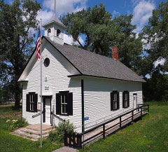 | District No. 48 School | building | 1997 | 96001612 |
 | Grand Army of the Republic Hall | building | 1975 | 75000995 |
| Litchfield Commercial Historic District | district | 1996 | 96000192 | |
 | Litchfield Opera House | building | 1984 | 84000019 |
| Ness Lutheran Church and Cemetery | district | 2025 | 100011871 | |
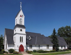 | Trinity Episcopal Church | building | 1975 | 75000996 |
 | Universal Laboratories Building | building | 1996 | 96000191 |
Every wildfire the federal occurrence database records inside this county: 20 of them, burning about 766 acres. 1 started naturally and 1 was recorded as arson. Each settlement page carries the fires within five miles of it.
| Reported cause | Fires |
|---|---|
| Debris and open burning | 8 |
| Missing data/not specified/undetermined | 7 |
| Power generation/transmission/distribution | 1 |
| Equipment and vehicle use | 1 |
| Arson/incendiarism | 1 |
| Recreation and ceremony | 1 |
| Natural | 1 |
The five largest, by the area the report gives. None of them was recorded as arson.
| Date | Cause | Size | Reported by | Name on the report |
|---|---|---|---|---|
| 2 May 2015 | Debris and open burning | 217 acres | Litchfield Wetland Management District | STONE LAKE WF |
| 8 April 2012 | Missing data/not specified/undetermined | 124 acres | Litchfield Wetland Management District | COOMBS WF |
| 17 April 2009 | Debris and open burning | 113 acres | Minnesota Department of Natural Resources | not named |
| 26 April 2001 | Debris and open burning | 105 acres | Minnesota Department of Natural Resources | not named |
| 29 April 1997 | Debris and open burning | 63 acres | Minnesota Department of Natural Resources | not named |
| 1 May 2013 | Power generation/transmission/distribution | 39 acres | Litchfield Wetland Management District | LAKE HARDEN WF |
| 23 November 2002 | Debris and open burning | 32 acres | Litchfield Wetland Management District | TYRONE FLATS WPA WILDFIRE |
| 29 November 2012 | Debris and open burning | 26 acres | Minnesota Department of Natural Resources | not named |
Every settlement page carries the fires within five miles of it - see the settlement index below.
The NOAA Storm Events Database holds 373 reports for this county, causing no deaths, 8 injuries and about $13,920,500 in recorded property damage. Each settlement page carries the reports that name it.
| Kind of event | Reports |
|---|---|
| Hail | 185 |
| Thunderstorm Wind | 140 |
| Tornado | 26 |
| Funnel Cloud | 10 |
| Flash Flood | 6 |
| Heavy Rain | 5 |
| Lightning | 1 |
The most serious of them, by death, then injury, then recorded damage. The accounts are quoted exactly as the forecast office filed them.
| When | Event | Place named | Harm | What the report says |
|---|---|---|---|---|
| September 2005 | Thunderstorm Wind | Litchfield | 3 hurt | Fire and rescue officials reported that high winds overturned a trailer camper at Lake Ripley Campground. Three people were pined inside and were transported to the hospital after rescue. A woman and a man in the trailer suffered minor injuries and the third victim, a retired police officer, suffered cracked ribs and numbness in his legs. Two other unoccupied campers were overturned nearby and others were damaged. Trees were also downed around town. A wind gust of 55 MPH was recorded at the Litchfield airport at 3:55 PM CDT. |
| June 2017 | Thunderstorm Wind | Kingston | 2 hurt | There were 18 inch diameter trees fallen on the highway. In addition, the Minnesota State Patrol reported two people were hurt when wind gusts flipped a pickup and camper as the driver was moving onto the shoulder on a county road in Meeker County. They were taken to a hospital with non-life threatening injuries. |
| July 2011 | Hail | Dassel | 1 hurt, $500 | In addition, a driver was injured when hail the size of a baseball hit his vehicle's windshield. |
| June 2024 | Thunderstorm Wind | Greenleaf | 1 hurt | Sheriff's Office reported that a large pole barn had its roof blown off with all sides collapsing, resulting in one injury. |
| July 2016 | Tornado (EF2) | Watkins | 1 hurt | The tornado near Watkins was also rated an EF-2 with peak winds of 125 mph. It had a maximum width of 400 yards and traveled approximately 2.1 miles. One injury occurred with this tornado. The first significant damage was to a business along Highway 55 on the south side of town. The tornado then tracked across the highway and passed through the St. Anthony Cemetery before passing through the center of Watkins doing damage to structures and many trees. The most significant damage occurred between Stearns Ave and Meeker Ave where several homes had significant roof damage, and had detached sheds, and garages destroyed. The tornado exited the town and did further tree damage as the tornado moved northeast into Stearns County. |
| June 2001 | Thunderstorm Wind | Grove City | $10,000,000 | The storm complex moved into Meeker County, producing a 4 to 5 mile wide swath of damage from northwest to southeast across the county. The most severe damage was in Grove City and Litchfield. The Grove City High School auditorium roof collapsed, and light towers and other structures were destroyed at the Grove City race track. Hundreds of trees were toppled in Litchfield, many onto homes and vehicles. Dozens of barns, grain bins, and outbuildings sustained damage across the county. Homes were pummeled by wind-driven hail. Damage amount listed is for all events in Meeker County. |
| September 2005 | Hail | Dassel | $800,000 | Hail dented cars, along with roofs and siding of many houses. Some windows broken. Property damage total is for the Dassel area on 9-21-05. |
| June 2012 | Thunderstorm Wind | Grove City | $500,000 | Estimated severe straight-line winds of 75 mph caused major damage centered one mile south of Grove City, approximately 5 miles wide (east & west) to 6 miles north of Grove City. Damage was associated with dozens of trees, multiple power lines snapped and blown down, 14 buildings reported or found damaged moderately to severe to include over 1 half dozen metal barns, sheds, grain bins and one house with 1/2 roof torn off. Grove City High School bleachers blown over as well. |
| June 2003 | Thunderstorm Wind | Cosmos | $500,000 | Numerous trees down in a wide swath that originated in Kandiyohi County and extended into Meeker, Renville and McLeod Counties. Sheds and outbuildings were blown over across an approximate area of 40 to 50 square miles. Several grain bins were damaged, and the roof of the Cedar Mills liquor store was removed. The damage survey revealed that winds were from the north-northwest. |
| April 2001 | Flash Flood | Countywide | $300,000 | no account filed |
| July 1978 | Tornado (F1) | not stated | $250,000 | no account filed |
| July 2008 | Tornado (EF0) | Dassel | $200,000 | Damage survey team reported downed trees in Meeker County. The tornado continued into Wright County, where a roof was ripped off a home and some sheds were destroyed. |
| September 2006 | Tornado (F0) | Darwin | $200,000 | An NWS damage survey confirmed a fast moving tornado that ripped apart several large sheds and outbuildings. Scattered trees were downed. |
| June 2002 | Flash Flood | Countywide | $200,000 | Four to six inches of rain affected the northern and eastern portions of Meeker County. Ten roads were closed, and 5 others were covered with some water. A culvert washed out 3 NW Kingston, leading to a section of State Highway 24 collapsing. One family had to be rescued from a car 4 W Kingston. Water was over roads at Dassel, and numerous basements were flooded in Litchfield and Grove City. |
| July 2011 | Flash Flood | Eden Vly | $125,000 | Numerous county roads were flooded or closed due to excessive morning rainfall across the area. The main area was focused between Eden Valley, Forest City and Watkins. |
| August 2023 | Hail | Dassel | $100,000 | A photo of hail next to a ruler measured 3.75 inches with the largest stone near Hwy 15. There was damage to the siding on the west side of the house. |
| September 2019 | Thunderstorm Wind | Grove City | $100,000 | There was sporadic wind damage that occurred across all of Meeker County, especially in towns and bigger cities based on emergency manager notes. Numerous trees were blown down or uprooted, including a tree that had a diameter of 2 feet. There was an overturned pontoon on Big Swan Lake and several power lines and/or power poles blown down. |
| August 2018 | Tornado (EF0) | Grove City | $100,000 | This is the continuation of the same EF0 tornado that tracked across Kandiyohi county, and entered Meeker county. This tornado tracked an additional 9.5 miles east along Highway 12, through Grove City, to just northwest of Litchfield. Pockets of tree damage, an overturned trailer, and some other minor structural damage to sheds and pole barns resulted. Straight line wind damage, mostly to trees, was found south of the tornado |track and Highway 12. Maximum winds were estimated at 80 mph, with a width of 300 yards. |
| May 1998 | Thunderstorm Wind | Dassel | $100,000 | Semitrailer blown off highway 12. Estimated windspeed. |
| July 2016 | Hail | Rosendale | $50,000 | Although some hail reached 2.25 inches, most of the hail was one inch in diameter and lasted for 5 minutes. Some vehicle and roof damage occurred with the hail storm. |
| May 2015 | Tornado (EF0) | Darwin | $50,000 | This tornado knocked down dozens of trees, pushed a barn and other sheds off their foundations, and took the roof off a pole barn. |
| June 2012 | Thunderstorm Wind | Cosmos | $50,000 | A line of severe straight-line winds caused numerous large trees to snap off, and power poles to bend over around Cosmos. |
| July 2011 | Thunderstorm Wind | Cosmos | $50,000 | Numerous trees and power lines were blown down from near Cosmos, northeast of Cosmos where a farm was damaged. |
| July 2023 | Thunderstorm Wind | Crow River | $30,000 | A barn had part of its roof torn off. Several trees were also broken or uprooted. |
| May 2022 | Thunderstorm Wind | Dassel | $25,000 | A large shed was damaged, including a tree that blew down on a vehicle south of Dassel. |
| May 2012 | Thunderstorm Wind | (Y69)Litchfield Muni | $25,000 | Several large tree branches and one large tree blew down in the southern part of Litchfield. In addition, a plane was flipped over at the Litchfield airport. |
| July 2010 | Hail | Kingston | $25,000 | Several trained spotters reported numerous nickel, up to baseball size hail from near South Haven, south-southeast to near French Lake, Minnesota. |
| July 2010 | Thunderstorm Wind | Kingston | $25,000 | About one dozen trees were toppled due to a downburst. One tree fell on a house. |
| July 1977 | Tornado (F2) | not stated | $25,000 | no account filed |
| June 1969 | Tornado (F1) | not stated | $25,000 | no account filed |
| October 1963 | Tornado (F0) | not stated | $25,000 | no account filed |
| August 2011 | Lightning | Casey | $15,000 | Lightning struck a home near Darwin, and damaged the second floor. |
| May 2010 | Thunderstorm Wind | Grove City | $10,000 | A large tree was blown down onto a home near Grove City, Minnesota. |
| July 2003 | Thunderstorm Wind | Dassel | $10,000 | 70 foot HAM radio tower toppled. |
| July 2011 | Thunderstorm Wind | Dassel | $5,000 | A few large trees and power lines were blown down in Dassel. |
| June 2025 | Hail | Dassel | - | Multiple reports of quarter sized hail south of Dassel. |
| June 2025 | Thunderstorm Wind | Cosmos | - | Thunderstorm winds estimated at 60 mph downed powerlines 4 miles north of Cosmos. |
| July 2025 | Thunderstorm Wind | Watkins | - | Many trees damaged and stripped of leaves. |
| July 2025 | Thunderstorm Wind | Litchfield | - | Multiple trees down in Litchfield. |
| July 2025 | Thunderstorm Wind | Cosmos | - | Tree down in Cosmos. |
| August 2024 | Thunderstorm Wind | Forest City | - | Delayed report, time estimated from radar. Two trees were down across roads. |
| August 2024 | Thunderstorm Wind | Dassel | - | Delayed report, time estimated from radar. Tree down across road. |
| August 2024 | Hail | Corvuso | - | Report provided via spotter network of quarter size hail. |
| August 2024 | Thunderstorm Wind | Litchfield Muni Arpt | - | County dispatch reported a tree down near the intersection of Hwy-24 and 285th St. |
| July 2024 | Thunderstorm Wind | Crow River | - | Several dozen trees were downed or broken. A few landed on top of houses and sheds. |
| August 2023 | Hail | Dassel | - | A picture of hail next to a ruler on social media showed hail slightly larger than 3 inches. |
| August 2023 | Funnel Cloud | Cedar Mills | - | A trained spotter located in Hutchinson spotted a funnel cloud to the west and southwest. |
| July 2023 | Thunderstorm Wind | Eden Vly | - | There was a lot of tree and brach debris along with power outages near Eden Valley. |
| July 2023 | Thunderstorm Wind | Litchfield | - | Public works responded to 1 large branch across the road. |
| July 2023 | Hail | Dassel | - | Golfball size hail was reported 2 miles north of Dassel via social media. |
| July 2023 | Thunderstorm Wind | Crow River | - | Part of a roof was blown off a barn. Several trees at the farm were also broken or tipped over. |
| May 2022 | Thunderstorm Wind | Litchfield | - | The county courthouse sustained roof damage. Numerous trees were uprooted around Litchfield. Time estimated based on radar. |
| August 2020 | Tornado (EF0) | Crow River | - | This is the continuation of the Kandiyohi tornado that moved into Meeker County near 340th Street and 210th Street Southeast. The tornado continued to the northeast damaging many trees and corn/bean fields before dissipating near Crow River. It moved across one farmstead but only produced minor damage to outbuildings. At one point, a law enforcement officer along the Meeker/Kandiyohi line reported and videod one tornado to his south and another to his east. This tornado was the one to his east. |
| August 2020 | Tornado (EF0) | Crow River | - | This is the continuation track of the tornado that tracked across Kandiyohi County before dissipating shortly after moving into Meeker County. At one point, a law enforcement officer along the Meeker/Kandiyohi line reported and videod one tornado to his south and another to his east. This tornado was the one to his south. |
| August 2020 | Tornado (EF0) | Strout | - | An EF-0 tornado mostly tracked across corn fields, but it did strike a grove of trees and knock down some large tree limbs before dissipating northeast of Lake Minnie Belle. There was also downburst winds around this tornado that occurred west of the path, and just north of the lake between 205th Street, and 624th Avenue. |
| August 2019 | Funnel Cloud | Rosendale | - | A funnel cloud was observed near Rosendale. |
| August 2018 | Thunderstorm Wind | Forest City | - | Several trees were blown down near Forest City. |
| June 2017 | Thunderstorm Wind | Kingston | - | There were three sheds damaged and one destroyed, along with several trees down along Highway 15, north of Kingston. |
| June 2017 | Thunderstorm Wind | Grove City | - | Large branches were blown down. |
| June 2017 | Thunderstorm Wind | Grove City | - | Power poles were tipped over. Some large branches were also broken. |
The Survey's mineral resources record lists 4 workings inside this county. All of them still produce. Each settlement page carries the workings within five miles of it.
| Commodity | Workings |
|---|---|
| Sand and Gravel, Construction | 4 |
The least common of them first, because a county's hundredth gravel pit says nothing its first ten did not.
| Where | Site | Commodity | Status | Recorded |
|---|---|---|---|---|
| Nussbaum Pit and Mill | Sand and Gravel, Construction | Producer | ||
| Smith Pit | Sand and Gravel, Construction | Producer | ||
| Smith Pit and Mill | Sand and Gravel, Construction | Producer | ||
| Smith Pit and Mill | Sand and Gravel, Construction | Producer |
Album of History and Biography of Meeker County, Minnesota devotes a chapter to each township: its boundaries and streams, who settled it and when, the mills, the schools and the churches. All 5 are reproduced here in full. Each row shows the township's own shape and where it lies in the county, drawn from the Census Bureau's boundary. Which settlements belong to which township is computed from that same boundary, not taken from the book.
| Shape and position in the county | Township | Settlements in it | Length | Sections |
|---|---|---|---|---|
| Ellsworth Township | Casey, Greenleaf | 1,474 words | 1 | |
| Grove City City | Grove City | 824 words | 0 | |
| Kingston Township | Kingston | 1,049 words | 1 | |
| Litchfield City | Litchfield | 13,775 words | 5 | |
| Manannah Township | Manannah | 1,506 words | 2 |
2 books written about this county, cut here where the book itself is cut, at its printed chapters: 32 chapters in all. Every chapter is public domain, machine-read from the scan and reproduced complete. A chapter already given under one of the county's towns is not repeated in this list.
| Chapter | Length |
|---|---|
| Chapter 1 | 1,162 words |
| Chapter 2 | 4,330 words |
| Chapter 3 | 1,067 words |
| Chapter 4 | 2,184 words |
| Chapter 5 | 2,554 words |
| Chapter 6 | 907 words |
| Chapter 7: How the Boys Got Out of Acton | 1,705 words |
| Chapter 8 | 1,171 words |
| Chapter 9 | 2,030 words |
| Chapter 10: A Wild Woman's History-The Slayer of Hun¬ | 2,723 words |
| Dr. Frederick Xoah Ripley | 912 words |
| Chapter 12: Church History - Presbyterian Church | 986 words |
| Chapter 13: The Judiciary | 2,795 words |
| Chapter 14 | 1,494 words |
| Chapter | Length |
|---|---|
| Biographical sketches | 35,366 words in 3 parts |
| Chapter 1: Location, Topography and General Remarks | 646 words |
| Chapter 2: History of Minnesota - from 1660 to 1887 | 4,723 words |
| Chapter 3: The Indian Massacee | 3,782 words |
| Chapter 4: Teeritorial and State Officees | 171,291 words in 11 parts |
| Chapter 2: Early Settlement | 4,165 words |
| Chapter 3: Official Matters | 2,781 words |
| Chapter 5: Journalism and Education | 12,399 words |
| Chapter 8: Forest City Township | 1,660 words |
| Chapter 11: Cedar Mills Township | 942 words |
| Chapter 12: Swede Grove Township | 622 words |
| Dassel Tow'xship | 3,515 words |
| Chapter 14: Darwin Township | 740 words |
| Chapter 15: Harvey Township | 874 words |
| Litchfield Township | 739 words |
| Yiii | 798 words |
| Chapter 20: Forest Prairie Township | 729 words |
| Chapter 69: Greenleaf Township | 669 words |
Named settlements recorded in the Geographic Names Information System, each with the topographic sheets covering it. Villages, hamlets and abandoned places alike. Each is shown with the nearest named watercourse or landform and the survey quadrangle it falls on.
Litchfield city · 55355 · On Jewett Creek · Litchfield North quadrangle
10 sheets, 1953 to 1986
Manannah township · 56243 · On Middle Fork Crow River · Eden Valley quadrangle
8 sheets, 1953 to 1986