 Block
From the record
One of 22 National Register listings published here for Pine County · listed in 1997 · category: District.
Sources: the case file at the National Archives · the National Register database, National Park Service
Listed on the National Register of Historic Places in 1997.
One of 22 National Register listings published here for Pine County · listed in 1997 · category: District.
Sources: the case file at the National Archives · the National Register database, National Park Service
Regional context, not property-specific evidence. The federal wildfire occurrence database lists 39 fires within 5 miles of St. Croix Recreational Demonstration Area between 1992 and 2019, burning about 63 acres in total. 7 started naturally. 5 were recorded as arson. Distance is straight-line from the map coordinates, so a fire counted here may appear on a neighbouring settlement's page as well.
| Reported cause | Fires |
|---|---|
| Debris and open burning | 10 |
| Missing data/not specified/undetermined | 8 |
| Natural | 7 |
| Arson/incendiarism | 5 |
| Recreation and ceremony | 4 |
| Equipment and vehicle use | 2 |
| Smoking | 1 |
| Other causes | 1 |
| Fireworks | 1 |
The most recent of them, most recent first, with the day each was reported and the service that recorded it.
| Date | Cause | Size | Reported by | Name on the report |
|---|---|---|---|---|
| 5 September 2013 | Equipment and vehicle use | under an acre | Wisconsin Department of Natural Resources | EKDALL FLATS |
| 4 September 2003 | Missing data/not specified/undetermined | under an acre | Minnesota Department of Natural Resources | not named |
| 17 August 2005 | Natural | under an acre | Wisconsin Department of Natural Resources | not named |
| 17 August 2005 | Natural | under an acre | Wisconsin Department of Natural Resources | not named |
| 17 August 2005 | Natural | under an acre | Wisconsin Department of Natural Resources | not named |
| 17 August 2005 | Natural | under an acre | Wisconsin Department of Natural Resources | not named |
| 17 August 2005 | Natural | under an acre | Wisconsin Department of Natural Resources | not named |
| 13 August 2000 | Debris and open burning | under an acre | Wisconsin Department of Natural Resources | not named |
Regional context, not property-specific evidence. The National Weather Service names Hinckley, the town this property stands in, in 51 storm reports between 1994 and 2022: 29 hail, 18 thunderstorm wind, 3 tornado, 1 flash flood. No death or injury is recorded in these reports. Each account below is quoted exactly as the forecast office filed it, from the NOAA Storm Events Database, and each date opens the federal record of that event.
| When | Event | Place named | Harm | What the report says |
|---|---|---|---|---|
| August 2010 | Thunderstorm Wind | Hinckley | $2,000 | Power lines were blown down. |
| June 1994 | Tornado (F0) | Hinckley | $50 | A tornado touched down briefly downing several trees. |
| May 2022 | Thunderstorm Wind | Hinckley | - | Wind damage and downed trees at the Holiday gas station in Hinckley. This was near the start of the tornado. |
| May 2022 | Thunderstorm Wind | Hinckley | - | Trees were down just north of Hinckley on I-35. |
| May 2022 | Thunderstorm Wind | Hinckley | - | Widespread trees and power lines down in Hinckley. |
| May 2022 | Tornado (EF1) | Hinckley | - | Damage sustained to a fast food restaurant in Hinckley, including broken windows, a damaged rooftop HVAC unit, and evidence of metal flashing damage, is believed to be the beginning of a tornado that then tracked across Interstate 35 in a north-northwest direction, crossing the railroad tracks near 7th St NE. The majority of the damage was trees uprooted with several snapped along the way. Aerial imagery provided by the Pine County Sheriffs Department shows fairly weak but convergent tree fall between I-35 and near Highway 61 and Owl Drive between a distinct intensification where the treefall becomes much more extensive and a metal roof section was lifted off a local business. The tornado then tracked across Highway 61 and traversed north causing mainly tree damage with at least one home losing some roof shingles. The end of the tornado path is estimated due to the track moving into a much less wooded wetland area. NWS Duluth sincerely appreciates the drone imagery provided by the Pine County Sheriffs Office to aid in the assessment of this storm damage. Peak winds were estimated to be 95 mph. |
| August 2019 | Thunderstorm Wind | Hinckley | - | A photo was received showing a large tree branch down in the city of Hinckley. |
| August 2019 | Thunderstorm Wind | Hinckley | - | The gust was reported by the AWOS at the Hinckley Field of Dreams Airport. |
| July 2017 | Thunderstorm Wind | Hinckley | - | A few trees were either blown down or their trunks were snapped aloft. The largest tree affected was a 26 inch diameter elm tree snapped 8 feet off the ground. |
| July 2016 | Flash Flood | Hinckley | - | Some low-lying areas of Hinckley had more than 6 of water over the roads, including on a stretch of Dunn Avenue, and near the intersection of 3rd Street and Lawler Avenue. |
| July 2015 | Hail | Hinckley | - | The hail fell at Grand National Golf Course. |
| July 2015 | Hail | Hinckley | - | The hail fell for ten minutes. |
| July 2015 | Hail | Hinckley | - | The hail was observed at Grand Casino. |
| September 2014 | Hail | Hinckley | - | There was pea to quarter size hailstones. |
| July 2011 | Thunderstorm Wind | Hinckley | - | Numerous trees were blown down just east of Hinckley. |
| May 2008 | Thunderstorm Wind | Hinckley | - | An eight-inch diameter tree top was snapped off. |
| July 2008 | Thunderstorm Wind | Hinckley | - | Numerous trees were blown down. |
| July 2006 | Thunderstorm Wind | Hinckley | - | Trees and power lines were blown down. Park benches were blown over. |
| June 2005 | Tornado (F1) | Hinckley | - | This tornado traveled through St. Croix State Park. Numerous trees were blown down and uprooted. Fortunately, the tornado missed the camping and swimming areas. |
| September 2004 | Thunderstorm Wind | Hinckley | - | Power lines were blown down. |
| July 2017 | Hail | Hinckley | - | no account filed |
| June 2016 | Hail | Hinckley | - | no account filed |
| June 2016 | Hail | Hinckley | - | no account filed |
| August 2015 | Hail | Hinckley | - | no account filed |
| May 2012 | Hail | Hinckley | - | no account filed |
| May 2009 | Hail | Hinckley | - | no account filed |
| June 2005 | Hail | Hinckley | - | no account filed |
| April 2004 | Hail | Hinckley | - | no account filed |
| April 2004 | Hail | Hinckley | - | no account filed |
| April 2004 | Hail | Hinckley | - | no account filed |
| April 2004 | Hail | Hinckley | - | no account filed |
| July 2004 | Thunderstorm Wind | Hinckley | - | no account filed |
| June 2003 | Hail | Hinckley | - | no account filed |
| June 2002 | Hail | Hinckley | - | no account filed |
| July 2002 | Thunderstorm Wind | Hinckley | - | no account filed |
| September 2002 | Hail | Hinckley | - | no account filed |
| May 2001 | Hail | Hinckley | - | no account filed |
| May 2001 | Hail | Hinckley | - | no account filed |
| July 2000 | Hail | Hinckley | - | no account filed |
| July 2000 | Thunderstorm Wind | Hinckley | - | no account filed |
| August 2000 | Hail | Hinckley | - | no account filed |
| August 2000 | Hail | Hinckley | - | no account filed |
| August 2000 | Hail | Hinckley | - | no account filed |
| July 2000 | Hail | Hinckley | - | no account filed |
| July 2000 | Hail | Hinckley | - | no account filed |
| July 1999 | Hail | Hinckley | - | no account filed |
| June 1999 | Thunderstorm Wind | Hinckley | - | no account filed |
| September 1998 | Thunderstorm Wind | Hinckley | - | no account filed |
| September 1997 | Thunderstorm Wind | Hinckley | - | no account filed |
| May 1994 | Hail | Hinckley | - | no account filed |
| June 1994 | Hail | Hinckley | - | no account filed |
No historic map-sheet match is published for this property yet. That does not mean no map exists. This record needs a coordinate-quality review before it can be joined to a sheet boundary. Browse the county's mapped places while that work is pending.
Other National Register properties close enough to walk or drive between, ordered by distance from this one. Both positions come from the same geocoding pass that matched these properties to their map sheets.
| Photograph | Property | Distance | Listed |
|---|---|---|---|
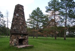 | St. Croix Recreational Demonstration Area | under 500 feet | 1997 |
| National Archives record | The nomination case file for reference 97001261 in Record Group 79. |
| Pine County | All 22 listed properties in this county. |