 Block
From the record
15 National Register listings published here.
Sources: the National Register database, National Park Service
64 topographic sheets cover 50 settlements here, and 15 properties are on the National Register of Historic Places.
15 National Register listings published here.
Sources: the National Register database, National Park Service
Every property in this county listed on the National Register of Historic Places, with the year it was listed and the federal nomination document.
| Photograph | Property | Type | Listed | Reference |
|---|---|---|---|---|
| Camp Smokey/Company 1713 Historic District | district | 1985 | 85000513 | |
| Cassbille Ranger Station Historic District | district | 2003 | 03000716 | |
| David W. Courdin House | district | 1971 | 71000460 | |
| Downtown Monett Historic District | district | 2014 | 14000373 | |
| Roaring River Camps and Hotel Summer Cottage | building | 2024 | 100009689 | |
| Roaring River State Park Bath House | building | 1985 | 85000500 | |
 | Roaring River State Park Dam/Spillway | structure | 1985 | 85000518 |
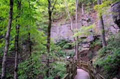 | Roaring River State Park Deer Leap Trail | structure | 1985 | 85000519 |
| Roaring River State Park Honeymoon Cabin | building | 1985 | 85000520 | |
| Roaring River State Park Hotel | building | 1985 | 85000501 | |
| Roaring River State Park Shelter Kitchen No. 2 and Rest Room | building | 1985 | 85000521 | |
| Tom Town Historic District | district | 1989 | 89002126 | |
| Waldensian Church and Cemetery of Stone Prairie | building | 1985 | 85000100 | |
| Wheaton Missouri and North Arkansas Railroad Depot | building | 2000 | 00000085 | |
| White Way Oil Company Station | building | 2026 | 100012649 |
Every wildfire the federal occurrence database records inside this county: 531 of them, burning about 8,853 acres. 5 started naturally and 101 were recorded as arson. Each settlement page carries the fires within five miles of it.
| Reported cause | Fires |
|---|---|
| Debris and open burning | 246 |
| Missing data/not specified/undetermined | 117 |
| Arson/incendiarism | 101 |
| Equipment and vehicle use | 30 |
| Smoking | 15 |
| Recreation and ceremony | 10 |
| Misuse of fire by a minor | 6 |
| Natural | 5 |
| Railroad operations and maintenance | 1 |
The five largest, by the area the report gives. Two of them were set deliberately.
| Date | Cause | Size | Reported by | Name on the report |
|---|---|---|---|---|
| 25 February 1995 | Missing data/not specified/undetermined | 480 acres | Missouri Department of Conservation | not named |
| 7 April 1995 | Debris and open burning | 355 acres | Missouri Department of Conservation | not named |
| 25 February 1995 | Missing data/not specified/undetermined | 260 acres | Mark Twain National Forest | CHUTES RIDGE |
| 2 April 1994 | Arson/incendiarism | 260 acres | Missouri Department of Conservation | not named |
| 18 March 1994 | Debris and open burning | 257 acres | Missouri Department of Conservation | not named |
| 18 April 1994 | Arson/incendiarism | 230 acres | Missouri Department of Conservation | not named |
| 12 March 2008 | Missing data/not specified/undetermined | 210 acres | Missouri Department of Conservation | BIG 10 |
| 18 February 2016 | Debris and open burning | 200 acres | Missouri Department of Conservation | 139581-00523-02182016-1230 |
Every settlement page carries the fires within five miles of it - see the settlement index below.
The NOAA Storm Events Database holds 1,021 reports for this county, causing 5 deaths, 51 injuries and about $137,097,750 in recorded property damage. Each settlement page carries the reports that name it.
| Kind of event | Reports |
|---|---|
| Hail | 351 |
| Thunderstorm Wind | 319 |
| Flash Flood | 184 |
| Flood | 76 |
| Tornado | 49 |
| Heavy Rain | 35 |
| Funnel Cloud | 4 |
| Lightning | 2 |
| Wildfire | 1 |
The most serious of them, by death, then injury, then recorded damage. The accounts are quoted exactly as the forecast office filed them.
| When | Event | Place named | Harm | What the report says |
|---|---|---|---|---|
| November 1988 | Tornado (F2) | not stated | 1 killed, 12 hurt, $2,500,000 | no account filed |
| February 2012 | Tornado (EF2) | Exeter | 1 killed, 4 hurt, $575,000 | An EF-2 rated tornado with a maximum wind speed of 120 mph tracked across northwestern portions of the city of Cassville. The tornado destroyed four mobile homes and one frame home. Another frame home was significantly damaged. This tornado also flipped over a tractor trailer as it crossed Highway 37. The tornado killed one person in a mobile home. There were four other injuries. |
| May 2008 | Tornado (EF2) | Pioneer | 1 killed, $10,000,000 | This tornado is an extension of the Newton County tornado. A National Weather Service storm survey revealed that an EF-2 tornado tracked across much of Barry County and directly impacted the community of Purdy. One man was killed as he was taking shelter in a mobile home. Numerous structures, trees, and power poles were destroyed. |
| April 1994 | Tornado (F1) | Seligman | 1 killed, $50,000 | A tornado touched down near the Missouri-Arkansas border and moved northeast towards the community of Seligman. A mobile home roof was damaged just inside the Missouri border north of Gateway, AR, as the storm moved northeast at 35 to 45 mph. The next touchdown was on the south edge of Seligman where a 60-year-old woman was killed in her mobile home. The storm destroyed a total of three mobile homes in the Heritage Heights Mobile Home Park. Several people observed debris rotating within the funnel. Another touchdown was in a deep ravine just east of town and uprooted several large trees laying them in a criss-cross pattern. (F60M) |
| June 2015 | Lightning | Scholten | 1 killed, $5,000 | A man died after being hit by lightning near Seymour. Two horses were also killed by the lightning strike. The man was cultivating a field at the time of the strike. Time was estimated. |
| October 1979 | Tornado (F2) | not stated | 9 hurt, $2,500,000 | no account filed |
| April 1972 | Tornado (F2) | not stated | 7 hurt, $2,500,000 | no account filed |
| April 1996 | Thunderstorm Wind | Exeter | 4 hurt, $500,000 | no account filed |
| March 1961 | Tornado (F1) | not stated | 4 hurt, $25,000 | no account filed |
| November 2001 | Tornado (F2) | Exeter | 3 hurt, $1,000,000 | no account filed |
| June 1995 | Tornado (F1) | Seligman | 3 hurt, $100,000 | A tornado tore through Roaring River State Park uprooting hundreds of trees and damaging nearly a 100 camper-trailers before lifting at Eagle Rock. |
| December 1972 | Tornado (F2) | not stated | 2 hurt, $25,000 | no account filed |
| March 1954 | Tornado (F3) | not stated | 2 hurt, $25,000 | no account filed |
| May 2009 | Thunderstorm Wind | Purdy | 1 hurt, $10,000 | A microburst destroyed a mobile home. One injury resulted from this wind damage. |
| April 2026 | Hail | Wheaton | $94,500,000 | A hail swath from a mile to 3 miles wide began near Wheaton and continued to the northeast across Barry County. Hail from quarters to 3 inches in size fell along a path from Wheaton to Purdy to Pleasant Ridge as an intensifying left moving supercell moved to the northeast across the County. Along the storms path, numerous homes, vehicles, businesses, equipment, crops, livestock and other structures were damaged by hail before the storm passed into southeastern Lawrence County. |
| December 2015 | Flash Flood | Mc Dowell | $5,000,000 | Route C near Flat Creek was closed due to high water. Numerous low water crossings, roads, and bridges were damaged or washed out throughout Barry County. Numerous homes and business suffered flood water damage as well throughout the county. This storm report will contain the damage estimates for the entire county for this event. |
| May 2009 | Thunderstorm Wind | Monett Friend Arpt | $4,000,000 | Destroyed outbuildings, damage to roofs and other structures, downed trees, and knocked over power poles were all a result of 50 to 85 mph wind gusts that impacted almost all of Barry County. Monett was impacted the greatest as hundreds of structures sustained roof damage. Meanwhile several outbuildings west of Monett along Highway 60 were completely destroyed. There were also destroyed outbuildings along Highway 37 near the community of Purdy. A large roof was torn off of a storage facility that blocked a city street for several hours in Monett. The Gizmo's Event Center grandstand in Wheaton was heavily damaged, which caused heavy rain to destroy the interior of a banquet hall that was being constucted beneath the grandstand. |
| July 2015 | Flash Flood | Eagle Rock | $2,000,000 | County Road 1135 at Roaring River State Park saw a flood wave between 4 and 6 feet move through the park in less than 10 minutes. This storm report will contain the overall flood damage estimates across Barry County for this storm event. There were several episodes and heavy rainfall events which led to a compound affect to the flooding damage. Numerous roads, bridges, and low water crossings were heavily damaged. Roaring River State Park suffered major damage to flood waters. |
| April 2017 | Flash Flood | Exeter | $1,000,000 | Several homes and business sustained flood damage across Barry County. Numerous roads and bridges were severely damaged or washed away across the county. This report will contain the total dollar estimate for flood damage to infrastructure, businesses, and homes across Barry County. |
| April 2011 | Flash Flood | Mc Dowell | $1,000,000 | Route C was closed due to flooding.||The total cost estimate for flooding damages for Barry County for this entire episode has been included. This includes roads, bridges, and structures which were affected. |
| April 2015 | Hail | Monett | $750,000 | Numerous reports of broken car windows across southern Lawrence and Barry Counties. Several car dealerships suffered severe damage from the large hail. |
| April 2008 | Flash Flood | Monett Friend Arpt | $750,000 | Two to four inches of rain fell over Barry County. Any areas that typically flood during periods of excessive rainfall were flooded. Large discharge values from Beaver Lake flowed into Table Rock Lake. This flooded low areas around the Lake in southeastern sections of the county. Also, Kelley Creek flooded numerous homes and businesses near in Monett. |
| August 2013 | Flash Flood | Eagle Rock | $650,000 | This storm report will include the total estimated damages for the flooding event. Roaring River State Park was flooded and evacuated. Several low water crossings and roadways were damaged due to flood waters. |
| April 2019 | Tornado (EF1) | Wheaton | $600,000 | This is the continuation of the tornado that touched down and tracked from five miles southwest of Rocky Comfort in McDonald County to five miles northeast of Wheaton, Missouri in Barry County. A National Weather Service survey confirmed an EF-1 tornado that tracked a total of 12 miles from five miles southwest of Rocky Comfort to five miles northeast of Wheaton, Missouri. The tornado was on the ground for approximately 22 minutes along its total track with maximum wind speeds estimated at 110 mph. After tracking across northeastern McDonald County the tornado then caused substantial damage to a commercial farming operation as it moved into Barry County near the intersection of Highways 76 and 86. While multiple large barns were heavily damaged, the most striking damage at this location was the destruction of a two story home, though it appeared that the lower walls had collapsed as the second story remained largely intact. Wind speeds associated with the home were reduced due to the lack of damage to nearby trees and power lines. The tornado continued to cause mainly roof damage to a number of homes as it crossed through the southern section of Wheaton. Clusters of more intense and a cyclonic tree fall pattern involving hundreds of trees were noted east of Wheaton interspersed with sections of limited damage as the tornado tracked northeast along portions of Highway W, through rural areas along Shoal Creek. Tree damage continued across Farm Roads 1035, 1040, Highway HH, and 1045 before the last visible damage to trees was noted north of Farm Road 2095. |
| May 2010 | Tornado (EF1) | Monett | $500,000 | A National Weather Service ground survey confirmed an EF-1 tornado initially touched down near the Plymouth Hill subdivision...then tracked through the Casino Park area before destroying the Pizza Hut and damaging several other structures. The tornado lifted near the race track on the eastern edge of Monett. Maximum winds were estimated at 100 to 110 mph with a maximum width of 200 yards. |
| January 2008 | Tornado (EF2) | Pioneer | $500,000 | A National Weather Service storm survey revealed that an EF-2 tornado tracked across rural areas between the communities of Monett and Purdy. The tornado intersected Highway 37 just south of its intersection with Highway BB. At this location, the tornado tore through a small mobile home park, destroying eight mobile homes. Additional houses and farm outbuildings were damaged along this tornado track. |
| January 2008 | Flash Flood | Seligman | $500,000 | Training supercells caused major flash flooding in countless locations across the county. Numerous roads and low water crossings were washed away. A few of the specific locations that received this flooding include a section of Farm Road 1095 just south of its intersection with Highway BB along the Barry and Lawrence county line, a section of Farm Road 1100 just south of its intersection with Highway C, a section of Farm Road 1160 just south of its intersection with 2240, the intersection of Farm Road 1150 and Farm Road 2010, and a section of Highway 97 three miles south of Pierce City. A water rescue was performed one mile northeast of Wheaton. Over five inches of rain was measured within a 6 hour time frame. |
| June 2000 | Flash Flood | Countywide | $500,000 | no account filed |
| March 2008 | Flash Flood | Monett | $400,000 | Five to six inches of rain fell over Barry County. All locations that typically flood during periods of excessive rainfall were flooded. Areas near Table Rock Lake were flooded from excessive discharge from Beaver Lake. Damage to roads and bridges occurred while several structures near Monett were flooded from Kelly Creek. |
| January 2008 | Tornado (EF1) | Wayne | $300,000 | A National Weather Service storm survey revealed that an EF-1 tornado developed along a squall line, and tracked across rural areas south of Cassville. A few houses and outbuildings sustained damage. Numerous trees were also damaged from this tornado. |
| February 1997 | Thunderstorm Wind | Monett | $250,000 | no account filed |
| June 2001 | Flash Flood | West Portion | $150,000 | no account filed |
| February 2023 | Hail | Shell Knob | $125,000 | Hail to the size of tennis balls was reported near Viola along Highway 39. Several buildings and a church had minor roof damage and multiple vehicles suffered hail damage. |
| April 2026 | Thunderstorm Wind | Monett | $100,000 | A least 3 trees were reported down on homes with winds estimated between 60 and 70mph along with pea sized hail. |
| May 2021 | Flash Flood | Monett | $100,000 | Significant flooding occurred along Kelly Creek as it rose out of its banks flooding numerous businesses and roads in town. |
| April 2020 | Thunderstorm Wind | Shell Knob | $100,000 | Minor dock and boat damage was reported by Central Crossing Fire near Shell Knob. |
| July 2004 | Thunderstorm Wind | Monett | $100,000 | Downburst winds significantly damaged several businesses and homes in Monett. Damage to the high school was also revealed in a National Weather Service storm survey. |
| April 2001 | Thunderstorm Wind | Wheaton | $100,000 | no account filed |
| August 1996 | Thunderstorm Wind | Eagle Rock | $100,000 | no account filed |
| December 2018 | Tornado (EF0) | Wightman | $90,000 | An EF-0 tornado with maximum estimated wind speed of 80 mph and path width of 25-50 yards tracked 0.12 miles to the east-northeast before lifting west of Highway 37. Roof damage occurred to several homes along the path and damaged a large tree before lifting. |
| April 2025 | Thunderstorm Wind | Shell Knob Turkey Ar | $80,000 | Multiple large tree limbs were reported down. Limbs fell on two vehicles and the corner of a home causing minor damage. |
| February 2023 | Thunderstorm Wind | Wightman | $75,000 | A few barns and outbuildings suffered minor to moderate damage and at least one power pole was broken. Power lines were reported laying on the road at the intersection of Highways 37 and BB. |
| August 2023 | Hail | Seligman | $75,000 | Wind driven quarters size resulted in minor siding and roof damage to a few homes. |
| April 2017 | Tornado (EF1) | Golden | $75,000 | A NWS storm survey confirmed an EF-1 crossed the Arkansas and Missouri border into extreme southeastern Barry County near St. Johns Wood Lane and the Kings River. Numerous trees were snapped or uprooted on a path through a near by hill side across the Kings River. A few trees were blown on to homes in the area. Estimated maximum wind speed was up to 90 mph. |
| May 2015 | Thunderstorm Wind | Monett | $75,000 | Several trees blown down in Monett. One tree damaged a boat. Another tree was on a house and an outbuilding. |
| July 2004 | Thunderstorm Wind | Countywide | $75,000 | A derecho affected areas of extreme southeast Kansas and extreme southern Missouri during the early morning hours of July 4th. As the storm tracked through Barry County, numerous trees and power lines were downed, along with minor structural damage to homes. Wind gusts in excess of 70 mph were estimated from the National Weather Service storm survey. |
| July 2023 | Thunderstorm Wind | Purdy | $60,000 | The roof of a chicken barn suffered significant damage along with several power lines reported down. Large round hay bails were reported to have blown across a road. |
| May 2024 | Tornado (EF1) | Monett Arpt | $55,000 | A NWS Survey team found EF-0 damage in northern Barry County as numerous large trees were uprooted. As the tornado continued to track northeast, it intensified to an EF-1 and caused damage to an outbuilding as well as the roofing material to a house just before crossing over the Barry/Lawrence County line, where it continued to track through southern Lawrence County. |
| April 2025 | Thunderstorm Wind | Wightman | $50,000 | Multiple trees and powerlines were reported. |
| June 2025 | Tornado (EF1) | Wheaton | $50,000 | An NWS Survey concluded that an EF1 tornado with up to 85 mph winds began at the Body of Christ church on the southwest side of Wheaton. The tornado was confirmed by several eyewitnesses along with rotational debris pattern to structures and trees. The tornado pulled multiple sections of roofing off poultry barns northeast of Wheaton before damaging trees a half mile northeast then dissipated. |
| March 2023 | Thunderstorm Wind | Butterfield | $50,000 | Multiple large trees were reported down. An out building also suffered significant damage and a machine shed was damaged as well. |
| July 2023 | Thunderstorm Wind | Monett | $50,000 | Several large limbs were reported down with some on power lines causing power outages. |
| March 2021 | Tornado (EF1) | Eagle Rock | $50,000 | A storm survey determined that a tornado with a maximum of EF-1 strength winds touched down initially five miles northeast of Eagle Rock and continued along an intermittent path of damage 25 miles long as it moved to the northeast. The majority of the damage path, 20 miles, was in Barry County before the tornado crossed into Stone County. Along its path the tornado topped or uprooted several hard and soft wood trees and damaged several outbuildings. The tornado crossed into Stone County along Farm Road 1250. The very rugged terrain precluded a full survey and lead to the intermittent designation. |
| March 2017 | Hail | Monett | $50,000 | This report was from social media with a picture. There was reports of damage to cars in the Monett area. |
| March 2017 | Hail | Golden | $50,000 | This report was from social media with pictures. There was some damage to cars and homes in the area. |
| May 2017 | Tornado (EF0) | Shell Knob | $50,000 | An EF-0 tornado uprooted numerous trees and damaged boat docks southeast of Shell Knob. Estimated maximum winds were up to 85 mph. |
| April 2015 | Hail | Monett | $50,000 | Several cars had damage and windows cracked. |
| June 2015 | Flash Flood | Cassville Flds Arpt | $50,000 | Route 86 was closed because of flooding. This storm report will contain the overall storm damage estimates across the entire Barry County for this storm event. Several roads, bridges, and low water crossings were damaged. |
| May 2013 | Tornado (EF1) | Shell Knob | $50,000 | An EF-0 tornado uprooted and damaged trees along its path. Winds were estimated around 110 mph. This tornado continued into Stone County. |
| August 2012 | Thunderstorm Wind | Eagle Rock | $50,000 | Numerous trees were blown down blocking roads at Roaring River State Park in and around the intersection of Highway 112 and Highway F. Several cars and a couple buildings were damaged by the fallen trees. |
The Survey's mineral resources record lists 73 workings inside this county. 2 still produce and 71 are closed or unrecorded. Each settlement page carries the workings within five miles of it.
| Commodity | Workings |
|---|---|
| Stone, Crushed/Broken | 30 |
| Lead, Zinc | 24 |
| Sand and Gravel, Construction | 5 |
| Iron | 3 |
| Zinc, Lead | 3 |
| Lead | 2 |
| Zinc | 2 |
| Uranium | 2 |
| Lead, Silver, Zinc | 1 |
| Iron, Lead, Zinc | 1 |
The least common of them first, because a county's hundredth gravel pit says nothing its first ten did not.
| Where | Site | Commodity | Status | Recorded |
|---|---|---|---|---|
| Lynn Cave Prospect | Lead, Silver, Zinc | Past Producer | ||
| Unknown - Iron-Lead-Zinc | Iron, Lead, Zinc | Past Producer | ||
| H L Burtner Uranium Mine | Uranium | Prospect | ||
| Radium Cave | Uranium | Prospect | ||
| Unknown - Lead | Lead | Past Producer | ||
| Unknown - Zinc | Zinc | Past Producer | ||
| Unknown - Zinc | Zinc | Past Producer | ||
| Upshur Mine | Lead | Past Producer | ||
| Allen & Stark Mine | Zinc, Lead | Past Producer | ||
| Kelley & Anderson Mines | Zinc, Lead | Past Producer | ||
| Unknown - Iron | Iron | Past Producer | ||
| Unknown - Iron | Iron | Past Producer | ||
| Unknown - Iron | Iron | Past Producer | ||
| Unknown - Lead-Zinc | Zinc, Lead | Past Producer | ||
| Unknown - S&G | Sand and Gravel, Construction | Past Producer | ||
| Unknown - S&G | Sand and Gravel, Construction | Past Producer | ||
| Unknown - S+G | Sand and Gravel, Construction | Past Producer | ||
| Unknown - S+G | Sand and Gravel, Construction | Past Producer | ||
| Unknown - S+G | Sand and Gravel, Construction | Past Producer | ||
| Feney Land | Lead, Zinc | Prospect | ||
| Henderson Mines | Lead, Zinc | Past Producer | ||
| Mcdowell Mines | Lead, Zinc | Past Producer | ||
| Monett | Lead, Zinc | Past Producer | ||
| Morton Land | Lead, Zinc | Past Producer | ||
| Northcutt Mine | Lead, Zinc | Past Producer | ||
| Pioneer Mine | Lead, Zinc | Past Producer | ||
| Polish Queen Mine | Lead, Zinc | Past Producer | ||
| Red Dog Mine | Lead, Zinc | Past Producer | ||
| Stanberry Diggings | Lead, Zinc | Past Producer | ||
| Unknown - Lead-Zinc | Lead, Zinc | Past Producer | ||
| Unknown - Lead-Zinc | Lead, Zinc | Past Producer | ||
| Unknown - Lead-Zinc | Lead, Zinc | Past Producer | ||
| Unknown - Lead-Zinc | Lead, Zinc | Past Producer | ||
| Unknown - Lead-Zinc | Lead, Zinc | Prospect | ||
| Unknown - Lead-Zinc | Lead, Zinc | Past Producer | ||
| Unknown - Lead-Zinc | Lead, Zinc | Past Producer | ||
| Unknown - Lead-Zinc | Lead, Zinc | Past Producer | ||
| Unknown - Lead-Zinc | Lead, Zinc | Past Producer | ||
| Unknown - Lead-Zinc | Lead, Zinc | Past Producer | ||
| Unknown - Lead-Zinc | Lead, Zinc | Past Producer | ||
| Unknown - Lead-Zinc | Lead, Zinc | Past Producer | ||
| Unknown - Lead-Zinc | Lead, Zinc | Past Producer | ||
| Unknown - Lead-Zinc | Lead, Zinc | Past Producer | ||
| Beydler Quarry | Stone, Crushed/Broken | Past Producer | ||
| Chas High Quarry | Stone, Crushed/Broken | Past Producer | ||
| Hutchens Quarry + Mill | Stone, Crushed/Broken | Producer | ||
| Knob Rock Quarry | Stone, Crushed/Broken | Past Producer | ||
| Knob Rock Quarry + Mill | Stone, Crushed/Broken | Past Producer | ||
| Madry Quarry | Stone, Crushed/Broken | Past Producer | ||
| Pulaskifield Quarry + Mill | Stone, Crushed/Broken | Producer | ||
| Roaring River Ls + Marble Quarry | Stone, Crushed/Broken | Past Producer | ||
| Unknown - Ls | Stone, Crushed/Broken | Past Producer | ||
| Unknown - Ls | Stone, Crushed/Broken | Past Producer | ||
| Unknown - Ls | Stone, Crushed/Broken | Past Producer | ||
| Unknown - Ls | Stone, Crushed/Broken | Past Producer | ||
| Unknown - Ls | Stone, Crushed/Broken | Past Producer | ||
| Unknown - Ls | Stone, Crushed/Broken | Past Producer | ||
| Unknown - Ls | Stone, Crushed/Broken | Past Producer | ||
| Unknown - Ls | Stone, Crushed/Broken | Past Producer | ||
| Unknown - Ls | Stone, Crushed/Broken | Past Producer | ||
| Unknown - Ls | Stone, Crushed/Broken | Past Producer | ||
| Unknown - Ls | Stone, Crushed/Broken | Past Producer | ||
| Unknown - Ls | Stone, Crushed/Broken | Past Producer | ||
| Unknown - Ls | Stone, Crushed/Broken | Past Producer | ||
| Unknown - Ls | Stone, Crushed/Broken | Past Producer | ||
| Unknown - Ls | Stone, Crushed/Broken | Past Producer | ||
| Unknown - Ls | Stone, Crushed/Broken | Past Producer | ||
| Unknown - Ls | Stone, Crushed/Broken | Past Producer | ||
| Unknown - Ss | Stone, Crushed/Broken | Past Producer | ||
| Unknown - Ss | Stone, Crushed/Broken | Past Producer | ||
| Unknown - Ss | Stone, Crushed/Broken | Past Producer | ||
| W H Sperry Quarry | Stone, Crushed/Broken | Past Producer | ||
| Washburn Quarry | Stone, Crushed/Broken | Past Producer |
Named settlements recorded in the Geographic Names Information System, each with the topographic sheets covering it. Villages, hamlets and abandoned places alike. Each is shown with the nearest named watercourse or landform and the survey quadrangle it falls on.
White River township · 65658 · On Sweetwater Creek · Viola quadrangle
15 sheets, 1927 to 1999
Roaring River township · 65641 · On Roaring River · Golden quadrangle
15 sheets, 1927 to 1999
Roaring River township · 65641 · Near Garner Hollow · Eagle Rock quadrangle
13 sheets, 1937 to 1999
Liberty township · 65647 · On Talbert Branch · Rocky Comfort quadrangle
14 sheets, 1941 to 1986
No longer a settlement
White River township · 65658 · On Viney Creek · Golden quadrangle
15 sheets, 1927 to 1999
Mountain township · 65605 · On Carney Creek · Elsey quadrangle
12 sheets, 1942 to 1985
No longer a settlement
Roaring River township · 65625 · Near Turkey Mountain · Golden quadrangle
15 sheets, 1927 to 1999
McDowell township · 65769 · On Little Flat Creek · McDowell quadrangle
11 sheets, 1943 to 1985
Mineral township · 65625 · Near Rockhouse Hollow · Cassville quadrangle
13 sheets, 1937 to 1999
Mineral township · 65625 · Near Sink Hole Ridge · Cassville quadrangle
13 sheets, 1937 to 1999
Crane Creek township · 65633 · On East Fork Jenkins Creek · Aurora quadrangle
12 sheets, 1942 to 1985
Liberty township · 65647 · On Talbert Branch · Rocky Comfort quadrangle
14 sheets, 1941 to 1986
Shell Knob township · 65747 · Near Ledgerwood Hollow · Shell Knob quadrangle
16 sheets, 1927 to 1999
McDonald township · 65734 · Near Kemp Hollow · McDowell quadrangle
11 sheets, 1943 to 1985
McDonald township · 65625 · Near Corder Hollow · Cassville quadrangle
13 sheets, 1937 to 1999
Washburn township · 65772 · Near Blockade Hollow · Seligman quadrangle
13 sheets, 1937 to 1999
The vanished settlements of Barry County: the places named above that are no longer on the map.