 Block
From the record
3 National Register listings published here · the county-history sources tell 2 stories.
Sources: the county history on the Internet Archive · the National Register database, National Park Service
81 topographic sheets cover 43 settlements here, and 3 properties are on the National Register of Historic Places.
3 National Register listings published here · the county-history sources tell 2 stories.
Sources: the county history on the Internet Archive · the National Register database, National Park Service
Among them: Noted Criminal Trials; Cholera. These passages come from the identified county-history source books. Each inset names its own source and opens the exact section it comes from.
In 1840, Wm. Grizzle was tried on a change of venue from Pulaski County. He was indicted and found guilty of murder in the first degree and Sheriff Smith erected a scaffold for his execution in the hollow, between the hills, a short distance south of Mr. E. S. Drake's house. A large concourse of people gathered to witness the execution, and the prisoner was on the scaffold, when a commutation by the Grovernor to imprisonment in the Penitentiary was produced.
CHOLERA. The year 1849 is notable for the prevalence of cholera at Warsaw. In June of that year James Blakey and William Peak returned from the South, where they had taken a drove of horses. On June 6th, Mr. Blakey, who was the husband of Mrs. Sarah B. Blakey, still liviog at Warsaw, was attacked with cholera, and died the next day.
Every property in this county listed on the National Register of Historic Places, with the year it was listed and the federal nomination document.
| Photograph | Property | Type | Listed | Reference |
|---|---|---|---|---|
| Central Cole Camp Historic District | district | 2002 | 02000355 | |
| Augustus Sander House | building | 2004 | 04000581 | |
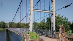 | Upper Bridge | structure | 1999 | 99001159 |
Every wildfire the federal occurrence database records inside this county: 393 of them, burning about 13,264 acres. 3 started naturally and 78 were recorded as arson. Each settlement page carries the fires within five miles of it.
| Reported cause | Fires |
|---|---|
| Debris and open burning | 176 |
| Missing data/not specified/undetermined | 108 |
| Arson/incendiarism | 78 |
| Equipment and vehicle use | 13 |
| Recreation and ceremony | 8 |
| Smoking | 4 |
| Natural | 3 |
| Power generation/transmission/distribution | 3 |
The five largest, by the area the report gives. One of them was set deliberately.
| Date | Cause | Size | Reported by | Name on the report |
|---|---|---|---|---|
| 19 January 2006 | Missing data/not specified/undetermined | 1,803 acres | Missouri Department of Conservation | WHITE ROCK FIRE |
| 22 September 1999 | Debris and open burning | 537 acres | Missouri Department of Conservation | not named |
| 21 March 1995 | Debris and open burning | 498 acres | Missouri Department of Conservation | not named |
| 23 March 2009 | Missing data/not specified/undetermined | 455 acres | Missouri Department of Conservation | KNOBBY FIRE |
| 15 March 2006 | Missing data/not specified/undetermined | 432 acres | Missouri Department of Conservation | SHOCKMAN FIRE |
| 22 March 1994 | Arson/incendiarism | 400 acres | Missouri Department of Conservation | not named |
| 23 March 2018 | Missing data/not specified/undetermined | 302 acres | Missouri Department of Conservation | 176262-01503-03232018-2100 |
| 2 April 1995 | Debris and open burning | 283 acres | Missouri Department of Conservation | not named |
Every settlement page carries the fires within five miles of it - see the settlement index below.
The NOAA Storm Events Database holds 561 reports for this county, causing 7 deaths, 53 injuries and about $8,191,620 in recorded property damage. Each settlement page carries the reports that name it.
| Kind of event | Reports |
|---|---|
| Thunderstorm Wind | 199 |
| Hail | 181 |
| Flash Flood | 95 |
| Flood | 33 |
| Tornado | 31 |
| Heavy Rain | 18 |
| Wildfire | 2 |
| Lightning | 2 |
The most serious of them, by death, then injury, then recorded damage. The accounts are quoted exactly as the forecast office filed them.
| When | Event | Place named | Harm | What the report says |
|---|---|---|---|---|
| July 1996 | Flash Flood | Warsaw | 2 killed, $10,000 | no account filed |
| July 2004 | Thunderstorm Wind | Countywide | 1 killed, 48 hurt, $350,000 | A derecho swept across much of west central and central Missouri during the early morning hours of July 5th. Severe winds from this line of thunderstorms affected a campground near Truman Lake where 48 people were injured. One fatality occurred as a 47 year old man drove his boat over the lake while the storm swept through. Thirty five homes and businesses were damaged. |
| July 2019 | Flash Flood | Dell Jct | 1 killed | Law enforcement reported a woman was swept off her feet while crossing a flooded driveway. The location is within headwaters of small unnamed basins leading to uncertainty of the precise location of the flood. |
| August 2011 | Lightning | Warsaw | 1 killed | A person was struck by lightning and killed while standing on a courtesy dock helping pull a boat out of the water. |
| April 2009 | Flash Flood | Brandon | 1 killed | Flooding occurred along a few creeks in northwest Benton County. One fatality occurred when a rancher was checking on his cattle and was swept into a flooded creek. |
| June 2004 | Thunderstorm Wind | Warsaw | 1 killed | Two men were fishing on Truman Lake near Warsaw while a squall line rapidly pushed across the lake and swamped their boat. Vance Wiles age 40, drowned as he tried to swim to shore without a life jacket. The other passenger Mark Johnson age 37, was wearing a life jacket and survived the accident. |
| April 1973 | Tornado (F3) | not stated | 4 hurt, $250,000 | no account filed |
| March 1982 | Tornado (F3) | not stated | 1 hurt, $2,500,000 | no account filed |
| July 2015 | Tornado (EF1) | Racket | $500,000 | A NWS storm survey concluded that a EF-1 tornado touched down on the west side of Warsaw. The estimated maximum wind speeds were up to 95 mph. The tornado touched down about 3 miles northwest of Warsaw and lift just west of downtown Warsaw. The path width was estimated to be around a quarter of a mile wide and was on the ground for over 3 miles. Numerous trees were uprooted along the path. A metal building was damaged. A boat dock was flipped and heavily damaged with 7 boats sunk at the dock. A fireworks tent was blown over. There were a couple of trees that fell on to recreational vehicles at a RV park. |
| April 1994 | Tornado (F1) | Warsaw to | $500,000 | A tornado touched down near the intersection of Highway 7 and County Road UU west of Warsaw. A wood framed house, motel, and several other buildings in and near the Osage Bluff Recreational Area four miles south of Warsaw were heavily damaged. Power lines were also knocked down and several boat docks and walkways damaged. At the Osage Bluff Marina and Restaurant, a pick-up truck was blown across part of a parking lot, leaving skid marks from all four tires. Numerous trees were also blown down or snapped at the base. Weather spotters followed the tornado before it lifted along Highway 83. |
| April 1994 | Thunderstorm Wind | Warsaw | $500,000 | A roof was completely torn off a mobile home with lesser damage amounts to several other mobiles homes. Trees were also sheared off or uprooted. Reported by the county sheriff. |
| April 2026 | Tornado (EF1) | Tackner | $425,000 | An National Weather Service survey concluded an EF1 tornado touched down southwest of Warsaw, crossing the lake, and tracking just east of Highway 65. The tornado flipped several mobile homes resting on blocks, damaged signs and roofing associated with stores along Highway 65, and created a pattern of tree damage including many uprooted or snapped, surveyed through in-person and Sentinel-2 satellite surveys. The tornado tracked for a little over 6 miles with a path width of 200 yards and maximum wind speeds of 90mph. |
| November 1990 | Tornado (F1) | not stated | $250,000 | no account filed |
| October 1986 | Tornado (F1) | not stated | $250,000 | no account filed |
| April 1973 | Tornado (F2) | not stated | $250,000 | no account filed |
| April 1973 | Tornado (F3) | not stated | $250,000 | no account filed |
| May 1954 | Tornado (F2) | not stated | $250,000 | no account filed |
| May 2025 | Tornado (EF1) | Santiago | $160,000 | A NWS storm survey confirmed an EF-1 tornado with maximum wind speeds of 100 mph had uprooted and snapped numerous trees. As the tornado curled near the end of its lifespan it damaged three barns and downed several power poles. |
| May 2025 | Tornado (EF1) | Racket | $148,000 | A NWS storm survey confirmed that an EF-1 tornado with maximum winds of 100 mph caused widespread uprooted and snapped trees along with power lines downed. Several barns suffered varying degrees of damage along with the roof of one home. |
| May 2025 | Tornado (EF1) | Racket | $115,000 | A NWS survey team determined that an EF-1 tornado pushed a mobile home off its block, damaged outbuildings and snapped trees along a track west of Racket just east of the Henry Benton County line. Maximum wind speeds were determined to be 105 mph. |
| April 2016 | Hail | Cole Camp | $100,000 | There were multiple reports of large hail up to 2 inch in diameter. Numerous cars were damaged with dents and broken car windows in the area. There were reports of siding damage to a church and some homes due to the hail. There were multiple pictures of the large hail on social media. This storm report will include the total estimated damage cost for the entire county with this event. |
| March 2006 | Tornado (F1) | Brandon | $100,000 | This tornado is an extension of the Henry County tornado that eventually tracked into Pettis County following its track through far northwest Benton County. Damage to a few homes and barns along with trees and power poles occurred. |
| April 2026 | Thunderstorm Wind | Edmonson | $80,000 | Several power lines were reported down along Highway H. |
| April 2026 | Thunderstorm Wind | Warsaw | $80,000 | Numerous trees and powerlines were reported down in town with multiple power outages. |
| April 2026 | Tornado (EF0) | Whitakerville | $50,000 | A National Weather Service survey concluded an EF0 tornado caused damage to a building on 83 and Highway MM southeast of Warsaw. This tornado is also damaged multiple trees in the area which was confirmed via Sentinel-2 satellite data analysis. The tornado had maximum winds of 80 mph and was on the ground for about 0.4miles with a width of 200 yards. |
| February 2023 | Thunderstorm Wind | Crockerville | $50,000 | Numerous power outages were reported with power poles and lines down. |
| March 2006 | Tornado (F0) | Cole Camp | $50,000 | A weak tornado touched down two miles west of Cole Camp and tracked across rural areas northwest of the city. A few barns and outbuildings were damaged prior to the tornado dissipating near Highway JJ. |
| July 2002 | Thunderstorm Wind | Zora | $50,000 | no account filed |
| June 2021 | Thunderstorm Wind | Ionia | $45,000 | Numerous limbs were reported down along with several one to two foot diameter trees. Several power poles were reported leaning or broken with siding off a few homes. Winds were estimated at 60 to 70 mph lasting about 25 minutes. |
| June 2004 | Thunderstorm Wind | Cole Camp | $40,000 | A squall line rapidly moved across areas of west central and central Missouri during the overnight hours of June 12th. Areas of northern Benton County experienced the strongest winds out of these thunderstorms as several structures were damaged. One garage was completely destroyed along with numerous downed trees and powerlines. |
| April 2026 | Thunderstorm Wind | Warsaw | $30,000 | Trees and power lines were reported down. |
| March 2003 | Thunderstorm Wind | Cole Camp | $30,000 | no account filed |
| June 1999 | Flash Flood | Countywide | $30,000 | no account filed |
| April 2026 | Thunderstorm Wind | Lincoln | $25,000 | A National Weather Service Survey determined that damage was caused by straight line winds which uprooted or snapped multiple trees and caused damage to a metal building. |
| May 2025 | Thunderstorm Wind | Lincoln | $25,000 | Reports of tree damage in Lincoln on Highway 65. Electricity to the entire town was knocked out. Altogether, over 4000 homes and businesses lost power in Benton County. |
| August 2023 | Thunderstorm Wind | Crockerville | $25,000 | A few trees and powerlines were downed by high winds. |
| May 2002 | Thunderstorm Wind | Warsaw | $25,000 | no account filed |
| May 1990 | Tornado (F0) | not stated | $25,000 | no account filed |
| May 1980 | Tornado (F1) | not stated | $25,000 | no account filed |
| April 1960 | Tornado (F3) | not stated | $25,000 | no account filed |
| March 2026 | Thunderstorm Wind | Bentonville | $20,000 | Numerous power poles and power lines are down at Highway 83 and Highway EE northeast of Harper. |
| May 2024 | Hail | Racket | $20,000 | Report of tennis ball size hail northwest of Warsaw. |
| July 2023 | Thunderstorm Wind | Warsaw | $20,000 | Some large limbs up to 3 inches in diameter and some power lines were reported down. |
| June 2008 | Thunderstorm Wind | Cole Camp | $20,000 | Thunderstorm wind gusts downed a large tree into a house. |
| January 2008 | Tornado (EF0) | Lincoln | $20,000 | A Benton County newspaper reported that a tornado briefly touched down. The description and pictures from the article indicated that a pole barn had been heavily damaged. |
| June 2008 | Thunderstorm Wind | Warsaw | $20,000 | Several trees and power lines were damaged from thunderstorm wind gusts. |
| March 2000 | Wildfire | Countywide | $20,000 | no account filed |
| June 2022 | Thunderstorm Wind | Tackner | $15,000 | A power line was reported down and a small outbuilding suffered minor damage. |
| September 2018 | Flood | Santiago | $15,000 | A culvert was lifted upward due to heavy rainfall and asphalt was washed away on State Highway HH about 4 miles west of Highway 65 northwest of Lincoln, Missouri. |
| July 2018 | Thunderstorm Wind | Fristoe | $15,000 | Large tree limbs were reported down and damage occurred to some outbuildings. The time was estimated by radar and the report was received via social media. |
| May 2004 | Lightning | Lincoln | $15,000 | A teen center was struck by lightning and partially burned down from a fire that developed. |
| June 1998 | Hail | Lakeview Hgt | $15,000 | no account filed |
| May 1997 | Thunderstorm Wind | Fristoe | $15,000 | no account filed |
| December 2024 | Tornado (EF0) | Zora | $12,000 | A National Weather Service storm survey determined that an EF-0 tornado occurred near the town of Zora. Several trees were damaged along with an outbuilding. The tornado traveled along a 1.7 mile path with maximum estimated winds at 80 mph and a path width of 75 yards. |
| April 2026 | Thunderstorm Wind | Fairfield | $10,000 | A power line was reported down at the entrance Osage Bluff Camp. |
| April 2026 | Thunderstorm Wind | Warsaw | $10,000 | A tree fell on a vehicle on Hawthorn Drive. |
| April 2026 | Thunderstorm Wind | Warsaw | $10,000 | A tree fell onto a power line. |
| May 2024 | Thunderstorm Wind | Warsaw | $10,000 | Report of a tree down on a powerline that caused power outages in town. |
| April 2024 | Thunderstorm Wind | Cole Camp | $10,000 | An irrigation pivot arm was rolled over and a large tree was damaged by high winds. |
| August 2023 | Flash Flood | Zora | $10,000 | Highway WW at Archer Creek was flooded with a portion of the road surface washed out due to flood waters. |
The Survey's mineral resources record lists 82 workings inside this county. 5 still produce and 77 are closed or unrecorded. Each settlement page carries the workings within five miles of it.
| Commodity | Workings |
|---|---|
| Barium-Barite | 21 |
| Stone, Crushed/Broken | 17 |
| Sand and Gravel, Construction | 13 |
| Iron | 8 |
| Barium-Barite, Lead | 6 |
| Lead, Zinc | 5 |
| Zinc | 4 |
| Lead | 3 |
| Flagstone | 2 |
| Barium-Barite, Zinc | 1 |
| Zinc, Lead | 1 |
| Coal, Zinc | 1 |
The least common of them first, because a county's hundredth gravel pit says nothing its first ten did not.
| Where | Site | Commodity | Status | Recorded |
|---|---|---|---|---|
| Brown Mine | Barium-Barite, Zinc | Past Producer | ||
| Unknown - Coal-Zinc | Coal, Zinc | Past Producer | ||
| Unknown - Lead-Zinc | Zinc, Lead | Past Producer | ||
| Chmelir Quarry | Flagstone | Past Producer | ||
| Neff Quarry | Flagstone | Past Producer | ||
| Deer Creek Mines | Lead | Past Producer | ||
| Gustka Diggings | Lead | Past Producer | ||
| Hopkins Diggings | Lead | Past Producer | ||
| Holderman Diggings | Zinc | Past Producer | ||
| Schumaker Shaft | Zinc | Past Producer | ||
| Unknown - Zinc | Zinc | Past Producer | ||
| Unknown - Zinc | Zinc | Past Producer | ||
| Unknown - Lead-Zinc | Lead, Zinc | Past Producer | ||
| Unknown - Lead-Zinc | Lead, Zinc | Past Producer | ||
| Unknown - Lead-Zinc | Lead, Zinc | Past Producer | ||
| Unknown - Lead-Zinc | Lead, Zinc | Past Producer | ||
| White Diggings | Lead, Zinc | Past Producer | ||
| Albert Schwald Property Number Two | Barium-Barite, Lead | Prospect | ||
| Campbell Brothers Mine | Barium-Barite, Lead | Past Producer | ||
| Unknown - Lead-Barite | Barium-Barite, Lead | Prospect | ||
| Unknown - Lead-Barite | Barium-Barite, Lead | Past Producer | ||
| Unknown - Lead-Barite | Barium-Barite, Lead | Prospect | ||
| Unknown - Lead-Barite | Barium-Barite, Lead | Prospect | ||
| Carpenter Bank | Iron | Past Producer | ||
| Charles Millers Land | Iron | Past Producer | ||
| Grissom Bank | Iron | Past Producer | ||
| Gun Bank | Iron | Past Producer | ||
| Indian Creek Bank | Iron | Past Producer | ||
| Richwoods Bank | Iron | Past Producer | ||
| Sands Bank | Iron | Past Producer | ||
| Smith Mine | Iron | Past Producer | ||
| Bailey Gravel Pit + Plant | Sand and Gravel, Construction | Producer | ||
| Bailey Sand + Gravel Pit | Sand and Gravel, Construction | Past Producer | ||
| Byler Branch Gravel Pit | Sand and Gravel, Construction | Producer | ||
| Unknown - S+G | Sand and Gravel, Construction | Past Producer | ||
| Unknown - S+G | Sand and Gravel, Construction | Past Producer | ||
| Unknown - S+G | Sand and Gravel, Construction | Past Producer | ||
| Unknown - S+G | Sand and Gravel, Construction | Past Producer | ||
| Unknown - S+G | Sand and Gravel, Construction | Past Producer | ||
| Unknown - S+G | Sand and Gravel, Construction | Past Producer | ||
| Unknown - S+G | Sand and Gravel, Construction | Past Producer | ||
| Unknown - S+G | Sand and Gravel, Construction | Past Producer | ||
| Unknown - S+G | Sand and Gravel, Construction | Past Producer | ||
| Unknown - S+G | Sand and Gravel, Construction | Past Producer | ||
| Lincoln Quarry | Stone, Crushed/Broken | Past Producer | ||
| Northwest Quarry Mine & Mill | Stone, Crushed/Broken | Producer | ||
| Palo Quarry | Stone, Crushed/Broken | Past Producer | ||
| Phillips Quarry | Stone, Crushed/Broken | Past Producer | ||
| Santiago Quarry | Stone, Crushed/Broken | Past Producer | ||
| Unknown - Ls | Stone, Crushed/Broken | Past Producer | ||
| Unknown - Ls | Stone, Crushed/Broken | Past Producer | ||
| Unknown - Ls | Stone, Crushed/Broken | Past Producer | ||
| Unknown - Ls | Stone, Crushed/Broken | Past Producer | ||
| Unknown - Ls | Stone, Crushed/Broken | Past Producer | ||
| Unknown - Ls | Stone, Crushed/Broken | Past Producer | ||
| Unknown - Ls | Stone, Crushed/Broken | Past Producer | ||
| Unknown - Ls | Stone, Crushed/Broken | Past Producer | ||
| Unknown - Ls | Stone, Crushed/Broken | Past Producer | ||
| Unknown - Ls | Stone, Crushed/Broken | Past Producer | ||
| Warsaw Northwest Mine Qry 1 & Plnt | Stone, Crushed/Broken | Producer | ||
| Warsaw South Mine Quarry #2 & Plant | Stone, Crushed/Broken | Producer | ||
| Albert Schwald Property Number One | Barium-Barite | Past Producer | ||
| Bertha Brunjes Land | Barium-Barite | Past Producer | ||
| Blackman Mine | Barium-Barite | Past Producer | ||
| Blue Goose Mine | Barium-Barite | Past Producer | ||
| Blue Goose Mine | Barium-Barite | Past Producer | ||
| Chick Young Mine | Barium-Barite | Past Producer | ||
| Cliffs of Dover Prospect | Barium-Barite | Past Producer | ||
| Craig Mine | Barium-Barite | Past Producer | ||
| Moelman Prospect | Barium-Barite | Past Producer | ||
| Schumacher Property | Barium-Barite | Past Producer | ||
| Tahoma Mine | Barium-Barite | Past Producer | ||
| Taylor Prospect | Barium-Barite | Past Producer | ||
| Unknown - Barite | Barium-Barite | Past Producer | ||
| Unknown - Barite | Barium-Barite | Past Producer | ||
| Unknown - Barite | Barium-Barite | Past Producer | ||
| Unknown - Barite | Barium-Barite | Past Producer | ||
| Unknown - Barite | Barium-Barite | Prospect | ||
| Unknown - Barite | Barium-Barite | Prospect | ||
| Unknown - Barite | Barium-Barite | Past Producer | ||
| Unknown - Barite | Barium-Barite | Past Producer | ||
| Unknown - Barite | Barium-Barite | Prospect |
A Sketch of the History of Benton County, Missouri devotes a chapter to each township: its boundaries and streams, who settled it and when, the mills, the schools and the churches. All 5 are reproduced here in full. Each row shows the township's own shape and where it lies in the county, drawn from the Census Bureau's boundary. Which settlements belong to which township is computed from that same boundary, not taken from the book.
| Shape and position in the county | Township | Settlements in it | Length | Sections |
|---|---|---|---|---|
| Alexander Township | Bentonville, Fairfield, Pom-o-sa Heights, Wisdom | 70 words | 0 | |
| Cole Township | Edmonson, Hilda, Lakeview Heights, Zora | 445 words | 1 | |
| Union Township | Edwards, Hastain, Knobby, Lively, Walkers Corner | 15,139 words | 15 | |
| White Township | Brandon, Ionia, Lincoln, Palo Pinto, Santiago | 86 words | 0 | |
| Williams Township | Cole Camp, Cole Camp Junction, Crest, Crockerville, Lake Creek, Mora, Windsor Junction | 93 words | 0 |
Named settlements recorded in the Geographic Names Information System, each with the topographic sheets covering it. Villages, hamlets and abandoned places alike. Each is shown with the nearest named watercourse or landform and the survey quadrangle it falls on.
Alexander township · 65355 · Near Button Hollow · Quincy quadrangle
20 sheets, 1887 to 1983
Cole township · 65338 · On Duran Creek · Lakeview Heights quadrangle
21 sheets, 1887 to 1983
Alexander township · 65355 · On Little Pomme de Terre River · Warsaw West quadrangle
23 sheets, 1887 to 1983
No longer a settlement
Cole township · 65338 · On Brushy Creek · Lakeview Heights quadrangle
21 sheets, 1887 to 1983
North Lindsey township · 65355 · Near Sugarcamp Hollow · Shawnee Bend quadrangle
22 sheets, 1887 to 1983
Fristoe township · 65355 · On Helton Branch · Warsaw East quadrangle
23 sheets, 1887 to 1983
Alexander township · 65355 · On Vance Branch · Warsaw West quadrangle
23 sheets, 1887 to 1983
Tom township · 65355 · Near Sugarcamp Hollow · Warsaw West quadrangle
23 sheets, 1887 to 1983
Union township · 65326 · Near Wayne Hollow · Knobby quadrangle
20 sheets, 1887 to 1983
South Lindsey township · 65355 · On Blue Branch · Warsaw West quadrangle
23 sheets, 1887 to 1983
Tom township · 65355 · On North Fork Blue Branch · Warsaw East quadrangle
23 sheets, 1887 to 1983
Fristoe township · 65355 · On White Branch · Warsaw East quadrangle
23 sheets, 1887 to 1983
Alexander township · 65355 · On Little Hogles Creek · Warsaw West quadrangle
23 sheets, 1887 to 1983
The vanished settlements of Benton County: the places named above that are no longer on the map.