 Block
From the record
7 National Register listings published here.
Sources: the county history on the Internet Archive · the National Register database, National Park Service
74 topographic sheets cover 44 settlements here, and 7 properties are on the National Register of Historic Places.
7 National Register listings published here.
Sources: the county history on the Internet Archive · the National Register database, National Park Service
Every property in this county listed on the National Register of Historic Places, with the year it was listed and the federal nomination document.
| Photograph | Property | Type | Listed | Reference |
|---|---|---|---|---|
| Robert A. Brown House | building | 1970 | 70000327 | |
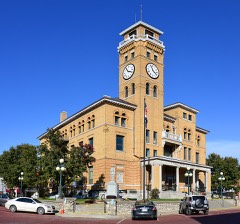 | Harrisonville Courthouse Square Historic District | district | 1994 | 94000315 |
| O'Bannon Homestead | building | 1979 | 79001356 | |
| Pleasant Hill Downtown Historic District | district | 2005 | 04000781 | |
| St. Peter's Episcopal Church | building | 1982 | 82003132 | |
| Stumbaugh Post No. 180 GAR Hall | building | 2000 | 00000694 | |
| Watkins Family Farm Historic District | district | 2007 | 07000376 |
Every wildfire the federal occurrence database records inside this county: 10 of them, burning about 38 acres. None started naturally and none was recorded as arson. Each settlement page carries the fires within five miles of it.
| Reported cause | Fires |
|---|---|
| Debris and open burning | 8 |
| Missing data/not specified/undetermined | 1 |
| Recreation and ceremony | 1 |
The five largest, by the area the report gives. None of them was recorded as arson.
| Date | Cause | Size | Reported by | Name on the report |
|---|---|---|---|---|
| 4 January 2018 | Missing data/not specified/undetermined | 16 acres | Missouri Department of Conservation | 165862-01917-01042018-1402 |
| 11 February 2003 | Recreation and ceremony | 15 acres | Missouri State Fire Marshal's Office | not named |
| 13 March 1996 | Debris and open burning | 2.0 acres | Missouri Department of Conservation | not named |
| 14 March 1992 | Debris and open burning | 1.0 acres | Missouri Department of Conservation | not named |
| 14 March 1992 | Debris and open burning | 1.0 acres | Missouri Department of Conservation | not named |
| 16 March 1992 | Debris and open burning | 1.0 acres | Missouri Department of Conservation | not named |
| 15 March 1995 | Debris and open burning | 1.0 acres | Missouri Department of Conservation | not named |
| 15 March 1995 | Debris and open burning | 1.0 acres | Missouri Department of Conservation | not named |
Every settlement page carries the fires within five miles of it - see the settlement index below.
The NOAA Storm Events Database holds 778 reports for this county, causing 4 deaths, 33 injuries and about $36,401,340 in recorded property damage. Each settlement page carries the reports that name it.
| Kind of event | Reports |
|---|---|
| Hail | 382 |
| Thunderstorm Wind | 281 |
| Flash Flood | 57 |
| Tornado | 41 |
| Flood | 14 |
| Heavy Rain | 2 |
| Lightning | 1 |
The most serious of them, by death, then injury, then recorded damage. The accounts are quoted exactly as the forecast office filed them.
| When | Event | Place named | Harm | What the report says |
|---|---|---|---|---|
| May 1977 | Tornado (F3) | not stated | 2 killed, 15 hurt, $25,000,000 | no account filed |
| April 1964 | Tornado (F3) | not stated | 1 killed, 10 hurt, $2,500,000 | no account filed |
| August 2003 | Thunderstorm Wind | Garden City | 1 killed, 2 hurt, $150,000 | Two mobile homes destroyed with two injuries. One of these injured died as a result of their injuries on September 3, 2003. One house had major damage with one injury. Numerous trees down or damaged along with outbuildings. |
| May 1999 | Thunderstorm Wind | Archie | 3 hurt, $50,000 | Roofs were torn off 2 houses by thunderstorm wind gusts. |
| May 2003 | Tornado (F1) | Freeman | 1 hurt, $1,000,000 | Tornado touched down 1 mile southeast of Freeman with F0 to F1 damage along a three mile track to 2 miles north northeast of Freeman where it lifted. Several RV's were flipped over in a RV park with one person injured. Tornado also did substantial damage to empty fuel tanks at a fuel farm, adjacent to the RV park. |
| June 2011 | Thunderstorm Wind | Belton | 1 hurt, $40,000 | A large number of trees were blown down. Several landed on mobile homes, with significant damage reported to one. One minor injury was reported, when a home owner sustained cuts climbing out a window. |
| April 2011 | Thunderstorm Wind | Lake Winnebago | 1 hurt, $30,000 | Thunderstorm wind gusts were estimated up to 70 mph. One injury was reported when a tree fell on a car. Buildings were reported damaged and trees were blown down, around Timber Street. |
| April 1995 | Hail | Harrisonville | $3,000,000 | ,,,,,,,,Thunderstorm Winds (G52) Gunn City,16,0924CST,0,0,0,0,500K,200K,Hail (1.75) Very large hail caused significant damage along a four-mile-wide path across the county from Cleveland to Harrisonville to Gunn City. The hail, driven by winds up to 60 mph shattered windows and punched holes in roofs. Numerous cars were damaged, including 95 percent of cars in each of two dealerships. A greenhouse was also destroyed near Gunn City. Some of the early wheat and alfalfa crops also suffered damage. |
| April 1964 | Tornado (F3) | not stated | $2,500,000 | no account filed |
| May 2004 | Flash Flood | Dayton | $500,000 | Torrential rainfall overnight with up to 8 inches in the area. 22 homes were evacuated in southern Freeman and 11 more families were evacuated from Lake Annette. |
| April 1995 | Hail | Belton | $500,000 | Large hail caused significant damage to cars at several car dealerships. |
| May 2003 | Tornado (F2) | Garden City | $200,000 | Tornado briefly touched down at Highway 7 and County Road Z interchange. No damage and was reported by storm chaser. Tornado touched back down just north of the interchange, and then continued intermittently for 4 miles to the Johnson county line around Latour, near the inersection of Routes 2 and 131. |
| October 1998 | Flash Flood | Pleasant Hill | $200,000 | no account filed |
| May 2020 | Thunderstorm Wind | Garden City | $100,000 | Winds of around 70 to 80 mph occurred in Garden City as a strong, decaying thunderstorm moved into that area. While the storm was severe, the winds in and around Garden City were somewhat unique to the event and the damage across the city indicated some enhanced winds, probably associated with a significant downburst. While the official estimate is around 70 to 80 mph winds, it's plausible that faster winds were experienced in that area with this event solely based on the damage. |
| March 2006 | Tornado (F2) | Creighton | $75,000 | Tornado crossed from Bates county into Cass county...6 miles south-southwest of Creighton at 2005 CST. It moved northeast and exited Cass county into Henry county at 2007 CST...2 miles south of Creighton. F1 damage to several structures was noted. |
| June 2011 | Thunderstorm Wind | Freeman | $50,000 | Thunderstorm wind gusts were estimated up to 70 mph. Tree and house damage was reported. Damage was reported to a gas station. |
| July 1994 | Thunderstorm Wind | Peculiar | $50,000 | A community center under construction in Peculiar was heavily damaged and large trees were blown down in Belton. |
| February 2007 | Tornado (EF1) | Gunn City | $30,000 | Tornado touched down at 10:05 PM CST, 1 mile east of Gunn City. The EF1 tornado destroyed a moble home before exiting the county into Johnson county at 10:06 PM CST, 2 miles east northeast of Gunn City. |
| September 2001 | Lightning | Belton | $25,000 | Lightning struck a house and the ensuing fire severely damaged the roof. |
| February 1999 | Thunderstorm Wind | Raymore | $25,000 | Outbuilding destroyed by thunderstorm winds. |
| June 1999 | Flood | Archie | $25,000 | Heavy rainfall from late-night thunderstorms produced urban flooding in the town of Archie. The area around City Hall and a city park were flooded. Standing water was reported inside the city hall, and a police cruiser parked outside was damaged by the flood waters. |
| June 2006 | Hail | Creighton | $25,000 | no account filed |
| May 1965 | Tornado (F1) | not stated | $25,000 | no account filed |
| April 1965 | Tornado (F1) | not stated | $25,000 | no account filed |
| April 1961 | Tornado (F1) | not stated | $25,000 | no account filed |
| April 1960 | Tornado (F3) | not stated | $25,000 | no account filed |
| September 1955 | Tornado (F1) | not stated | $25,000 | no account filed |
| June 2021 | Thunderstorm Wind | Harrisonville | $20,000 | There was a report of a roof blown off of a church in Harrisonville. |
| May 1995 | Thunderstorm Wind | Pleasant Hill | $20,000 | Winds gusted up to between 70 and 80 mph at the National Weather Service Office on the north side of Pleasant Hill. |
| July 2018 | Hail | Lake Winnebago | $10,000 | A storm producing golf ball sized hail did damage to NWS staff vehicles. |
| June 2010 | Tornado (EF0) | Harrisonville | $10,000 | Storm survey and eye witness accounts, confirm that an EF0 tornado touched down at 17:39 CST a little over one half mile south of Harrisonville. The tornado traveled around 2 miles to the east, before lifting at 17: 44 CST. A church had a roof blown off. There was also minor damage to a commercial building, and a number of trees were also damaged. |
| March 2006 | Thunderstorm Wind | Strasburg | $10,000 | Thunderstorm wind damage to residence. |
| March 2002 | Thunderstorm Wind | Garden City | $10,000 | Roof tiles blown off. Automobile had windshield shattered and roof dented in. TV antenna blown over. A single wide trailer moved 4 feet of its foundation. |
| April 1995 | Hail | Cleveland | $10,000 | ,,,,,,,,Thunderstorm Winds (G52) Gunn City,16,0924CST,0,0,0,0,500K,200K,Hail (1.75) Very large hail caused significant damage along a four-mile-wide path across the county from Cleveland to Harrisonville to Gunn City. The hail, driven by winds up to 60 mph shattered windows and punched holes in roofs. Numerous cars were damaged, including 95 percent of cars in each of two dealerships. A greenhouse was also destroyed near Gunn City. Some of the early wheat and alfalfa crops also suffered damage. |
| May 1995 | Thunderstorm Wind | Raymore | $10,000 | Severe thunderstorms produced damaging winds, with trees and power lines downed around the junction of Route J and Route 195. |
| May 2004 | Thunderstorm Wind | Archie | $8,000 | Power lines and poles down. Also part of a roof blown off and a door blown off. |
| August 2004 | Thunderstorm Wind | Garden City | $8,000 | Two barns destroyed and a grove of trees flattened. |
| April 2011 | Thunderstorm Wind | Belton | $7,500 | A roof was reported blown off a trailer home. Thunderstorm wind gusts were estimated up to 70 mph. |
| April 2011 | Thunderstorm Wind | Raymore | $5,000 | At the intersection of 195th Street and School Road, several power poles were reported to be leaning. One wooden power pole was split. Several outbuildings and one barn were reported destroyed or blown down. Thunderstorm wind gusts were estimated up to 70 mph. |
| June 2009 | Thunderstorm Wind | Drexel | $5,000 | Highway Patrol reported a mobile home park was hit with winds up to 70 mph. Five trailers were damaged. |
| August 2008 | Thunderstorm Wind | Creighton | $5,000 | Tree limbs up to 14 inches in diameter were reported down. Damage was reported to gutters on a home, with a front porch post blown off. Damage was also reported to the chimney. |
| July 2004 | Thunderstorm Wind | Pleasant Hill | $5,000 | 6 inch trees down and roof damage reported. |
| April 2007 | Hail | Harrisonville | $5,000 | no account filed |
| June 1996 | Thunderstorm Wind | Drexel | $5,000 | no account filed |
| May 2004 | Thunderstorm Wind | Belton | $4,000 | Siding damaged on house...large tree limbs down...large satellite dish damaged...2 by 4 supporting bird house snapped...between 210 and 211 block of Highway Y. |
| June 2010 | Flood | Pleasant Hill | $3,000 | An off duty NWS meteorologist, reported flooding near the the intersection of Front Street and Highway 58. Five homes had minor flooding. |
| June 2005 | Thunderstorm Wind | Raymore | $3,000 | Large tree down on car. |
| March 2000 | Thunderstorm Wind | Archie | $3,000 | Thunderstorm winds up to 75 mph damaged a farm near Archie. Three grain bins were knocked from their bases, and two of them were blown several hundred feet by thunderstorm winds. |
| August 1998 | Thunderstorm Wind | Drexel | $3,000 | Thunderstorm winds knocked down large tree limbs in Drexel. |
| May 1995 | Thunderstorm Wind | Pleasant Hill | $3,000 | Severe thunderstorms produced hail up to baseball size in several places around the county, and also produced wind gusts up to 80 mph. Numerous trees and large branches were downed around both the Pleasant Hill and Belton areas. |
| April 1961 | Tornado (F1) | not stated | $2,500 | no account filed |
| May 1955 | Tornado (F1) | not stated | $2,500 | no account filed |
| June 2004 | Thunderstorm Wind | Freeman | $2,000 | Power lines down. |
| June 2004 | Thunderstorm Wind | Harrisonville | $2,000 | Power lines down. |
| June 2004 | Thunderstorm Wind | Strasburg | $2,000 | Trees and power lines down. |
| May 2001 | Thunderstorm Wind | Raymore | $2,000 | Thunderstorm winds damaged several barns and downed numerous trees, at the intersection of Hwy 58 and Prairie Road. |
| May 1995 | Hail | Pleasant Hill | $2,000 | Severe thunderstorms produced hail up to baseball size in several places around the county, and also produced wind gusts up to 80 mph. Numerous trees and large branches were downed around both the Pleasant Hill and Belton areas. |
| July 1995 | Thunderstorm Wind | Harrisonville | $2,000 | Harrisonville PD reported thunderstorm wind gusts to 75 mph at Peculiar and roof torn off of a barn near Garden City. |
| May 1995 | Thunderstorm Wind | Belton | $2,000 | Severe thunderstorms produced hail up to baseball size in several places around the county, and also produced wind gusts up to 80 mph. Numerous trees and large branches were downed around both the Pleasant Hill and Belton areas. |
| May 1995 | Hail | Peculiar | $2,000 | Severe thunderstorms produced hail up to baseball size in several places around the county, and also produced wind gusts up to 80 mph. Numerous trees and large branches were downed around both the Pleasant Hill and Belton areas. |
The Survey's mineral resources record lists 55 workings inside this county. 8 still produce and 47 are closed or unrecorded. Each settlement page carries the workings within five miles of it.
| Commodity | Workings |
|---|---|
| Stone, Crushed/Broken | 51 |
| Clay | 2 |
| Sand and Gravel, Construction | 2 |
The least common of them first, because a county's hundredth gravel pit says nothing its first ten did not.
| Where | Site | Commodity | Status | Recorded |
|---|---|---|---|---|
| Unknown - Clay | Clay | Past Producer | ||
| Unknown - Clay | Clay | Past Producer | ||
| Unknown - S&G | Sand and Gravel, Construction | Past Producer | ||
| Unknown S&G | Sand and Gravel, Construction | Past Producer | ||
| Blue Valley Mines | Stone, Crushed/Broken | Past Producer | ||
| Blue Valley Mines | Stone, Crushed/Broken | Past Producer | ||
| Cleveland Quarry & Plant | Stone, Crushed/Broken | Producer | ||
| Cowger Quarry | Stone, Crushed/Broken | Past Producer | ||
| Garden City Quarry | Stone, Crushed/Broken | Producer | ||
| Greenwood Quarry and Mill | Stone, Crushed/Broken | Producer | ||
| Harrisonville Birch Plant | Stone, Crushed/Broken | Past Producer | ||
| Harrisonville Plant | Stone, Crushed/Broken | Producer | ||
| Lees Summit Quarry | Stone, Crushed/Broken | Past Producer | ||
| Limpus Harrisonville Quarry | Stone, Crushed/Broken | Producer | ||
| Main City Quarry - Plant | Stone, Crushed/Broken | Producer | ||
| McKee Quarry and Mill | Stone, Crushed/Broken | Producer | ||
| Peculiar Quarry | Stone, Crushed/Broken | Producer | ||
| Unknown - Ls | Stone, Crushed/Broken | Past Producer | ||
| Unknown - Ls | Stone, Crushed/Broken | Past Producer | ||
| Unknown - Ls | Stone, Crushed/Broken | Past Producer | ||
| Unknown - Ls | Stone, Crushed/Broken | Past Producer | ||
| Unknown - Ls. | Stone, Crushed/Broken | Past Producer | ||
| Unknown - Ls. | Stone, Crushed/Broken | Past Producer | ||
| Unknown - Ls. | Stone, Crushed/Broken | Past Producer | ||
| Unknown - Ls. | Stone, Crushed/Broken | Past Producer | ||
| Unknown - Ls. | Stone, Crushed/Broken | Past Producer | ||
| Unknown - Ls. | Stone, Crushed/Broken | Past Producer | ||
| Unknown - Ls. | Stone, Crushed/Broken | Past Producer | ||
| Unknown - Ls. | Stone, Crushed/Broken | Past Producer | ||
| Unknown - Ls. | Stone, Crushed/Broken | Past Producer | ||
| Unknown - Ls. | Stone, Crushed/Broken | Past Producer | ||
| Unknown - Ls. | Stone, Crushed/Broken | Past Producer | ||
| Unknown - Ls. | Stone, Crushed/Broken | Past Producer | ||
| Unknown - Ls. | Stone, Crushed/Broken | Past Producer | ||
| Unknown - Ls. | Stone, Crushed/Broken | Past Producer | ||
| Unknown - Ls. | Stone, Crushed/Broken | Past Producer | ||
| Unknown - Ls. | Stone, Crushed/Broken | Past Producer | ||
| Unknown - Ls. | Stone, Crushed/Broken | Past Producer | ||
| Unknown - Ls. | Stone, Crushed/Broken | Past Producer | ||
| Unknown - Ls. | Stone, Crushed/Broken | Past Producer | ||
| Unknown - Ls. | Stone, Crushed/Broken | Past Producer | ||
| Unknown - Ls. | Stone, Crushed/Broken | Past Producer | ||
| Unknown - Ls. | Stone, Crushed/Broken | Past Producer | ||
| Unknown - Ls. | Stone, Crushed/Broken | Past Producer | ||
| Unknown - Ls. | Stone, Crushed/Broken | Past Producer | ||
| Unknown - Ls. | Stone, Crushed/Broken | Past Producer | ||
| Unknown - Ls. | Stone, Crushed/Broken | Past Producer | ||
| Unknown - Ls. | Stone, Crushed/Broken | Past Producer | ||
| Unknown - Ls. | Stone, Crushed/Broken | Past Producer | ||
| Unknown - Ls. | Stone, Crushed/Broken | Past Producer | ||
| Unknown - Ls. | Stone, Crushed/Broken | Past Producer | ||
| Unknown - Ls. | Stone, Crushed/Broken | Past Producer | ||
| Unknown - Ls. | Stone, Crushed/Broken | Past Producer | ||
| Unknown - Ls. Quarries | Stone, Crushed/Broken | Past Producer | ||
| West Line Quarry | Stone, Crushed/Broken | Past Producer |
History of Cass County, Missouri devotes a chapter to each township: its boundaries and streams, who settled it and when, the mills, the schools and the churches. All 4 are reproduced here in full. Each row shows the township's own shape and where it lies in the county, drawn from the Census Bureau's boundary. Which settlements belong to which township is computed from that same boundary, not taken from the book.
| Shape and position in the county | Township | Settlements in it | Length | Sections |
|---|---|---|---|---|
| Index Township | Garden City, Gunn City, Hadsell | 187 words | 1 | |
| Peculiar Township | Coleman, Huber, Ore | 195 words | 0 | |
| Pleasant Hill Township | Baldwin Park, Pleasant Hill, Wyoming | 680 words | 0 | |
| Raymore Township | Harrelson, Raymore | 370 words | 1 |
One book written about this county, cut here where the book itself is cut, at its printed chapters: 41 chapters in all. Every chapter is public domain, machine-read from the scan and reproduced complete. A chapter already given under one of the county's towns is not repeated in this list.
Named settlements recorded in the Geographic Names Information System, each with the topographic sheets covering it. Villages, hamlets and abandoned places alike. Each is shown with the nearest named watercourse or landform and the survey quadrangle it falls on.
Polk township · 64080 · On East Branch Crawford Creek · East Lynne quadrangle
13 sheets, 1887 to 1983
No longer a settlement
Camp Branch township · 64743 · On Crooked Branch · East Lynne quadrangle
13 sheets, 1887 to 1983
Big Creek township · 64080 · On Middle Big Creek · Pleasant Hill quadrangle
15 sheets, 1887 to 1990
Index township · 64747 · On Crawford Creek · East Lynne quadrangle
13 sheets, 1887 to 1983
Grand River township · 64701 · On Town Creek · Harrisonville quadrangle
14 sheets, 1887 to 1983
Big Creek township · 64034 · On Alexander Creek · Pleasant Hill quadrangle
15 sheets, 1887 to 1990
Coldwater township · 64742 · On Cave Spring Creek · Freeman quadrangle
19 sheets, 1887 to 1983
Grand River township · 64701 · Near Emrick Hill · Austin quadrangle
14 sheets, 1887 to 1983
Camp Branch township · 64701 · East Lynne quadrangle
13 sheets, 1887 to 1983
No longer a settlement
Pleasant Hill township · 64080 · On Middle Big Creek · Pleasant Hill quadrangle
15 sheets, 1887 to 1990
Union township · 64012 · On West Fork East Creek · West Line quadrangle
19 sheets, 1887 to 1983
Camp Branch township · 64747 · Garden City quadrangle
13 sheets, 1887 to 1983
No longer a settlement
Grand River township · 64701 · Near Emrick Hill · Austin quadrangle
14 sheets, 1887 to 1983
No longer a settlement
Polk township · 64090 · On East Branch Crawford Creek · Strasburg quadrangle
15 sheets, 1887 to 1990
Pleasant Hill township · 64080 · On Middle Big Creek · Pleasant Hill quadrangle
15 sheets, 1887 to 1990
No longer a settlement
The vanished settlements of Cass County: the places named above that are no longer on the map.