 Block
From the record
8 National Register listings published here.
Sources: the National Register database, National Park Service
103 topographic sheets cover 42 settlements here, and 8 properties are on the National Register of Historic Places.
8 National Register listings published here.
Sources: the National Register database, National Park Service
Every property in this county listed on the National Register of Historic Places, with the year it was listed and the federal nomination document.
| Photograph | Property | Type | Listed | Reference |
|---|---|---|---|---|
| Dam and Spillway in the Hatchery Area at Montauk State Park | structure | 1985 | 85000528 | |
 | Dent County Courthouse | building | 1972 | 72000711 |
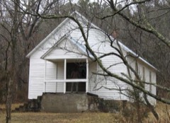 | Lower Parker School | district | 1991 | 91000604 |
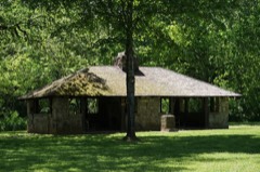 | Montauk State Park Open Shelter | building | 1985 | 85000529 |
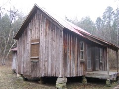 | Nichols Farm District | district | 1989 | 89002129 |
| Nova Scotia Ironworks Historic District | district | 2003 | 03000793 | |
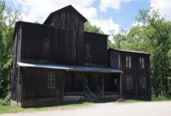 | Old Mill at Montauk State Park | building | 1985 | 85001478 |
| W. A. Young House | building | 1989 | 88000147 |
Every wildfire the federal occurrence database records inside this county: 755 of them, burning about 19,906 acres. 7 started naturally and 186 were recorded as arson. Each settlement page carries the fires within five miles of it.
| Reported cause | Fires |
|---|---|
| Debris and open burning | 352 |
| Arson/incendiarism | 186 |
| Missing data/not specified/undetermined | 147 |
| Equipment and vehicle use | 37 |
| Recreation and ceremony | 10 |
| Natural | 7 |
| Smoking | 7 |
| Power generation/transmission/distribution | 5 |
| Other causes | 2 |
| Misuse of fire by a minor | 2 |
The five largest, by the area the report gives. Three of them were set deliberately.
| Date | Cause | Size | Reported by | Name on the report |
|---|---|---|---|---|
| 1 November 2011 | Arson/incendiarism | 4,761 acres | Mark Twain National Forest | MINNINGHAW |
| 22 March 2007 | Missing data/not specified/undetermined | 750 acres | Missouri Department of Conservation | MATHES FIRE |
| 30 March 2006 | Missing data/not specified/undetermined | 539 acres | Mark Twain National Forest | SCHOOL HOUSE HOLLOW |
| 3 April 2011 | Equipment and vehicle use | 522 acres | Mark Twain National Forest | 75 FIRE |
| 12 April 2018 | Missing data/not specified/undetermined | 512 acres | Mark Twain National Forest | BUNKER SOUTH |
| 10 November 2010 | Arson/incendiarism | 378 acres | Mark Twain National Forest | HICKORY HOLLOW |
| 28 October 2000 | Debris and open burning | 373 acres | Mark Twain National Forest | HUZZAH |
| 2 April 2000 | Arson/incendiarism | 355 acres | Mark Twain National Forest | INDIAN CREEK |
Every settlement page carries the fires within five miles of it - see the settlement index below.
The NOAA Storm Events Database holds 401 reports for this county, causing 4 deaths, 4 injuries and about $20,442,550 in recorded property damage. Each settlement page carries the reports that name it.
| Kind of event | Reports |
|---|---|
| Hail | 131 |
| Thunderstorm Wind | 121 |
| Flash Flood | 53 |
| Flood | 49 |
| Heavy Rain | 25 |
| Tornado | 20 |
| Wildfire | 1 |
| Lightning | 1 |
The most serious of them, by death, then injury, then recorded damage. The accounts are quoted exactly as the forecast office filed them.
| When | Event | Place named | Harm | What the report says |
|---|---|---|---|---|
| December 2010 | Tornado (EF1) | Lecoma | 2 killed, $450,000 | The NWS survey team determined that an EF-1 tornado occurred. The tornado was estimated to be 100 yards wide along County Road 2050 near Lecoma with estimated winds of 90 to 100 mph. The tornado tracked approximately 1.5 miles before entering into rural Phelps County. Several structures had extensive damage or were destroyed along its path including a mobile home near Lecoma where 2 fatalities occurred. |
| May 2017 | Flood | Jack | 1 killed, $10,000 | The Missouri State Highway Patrol reported that a man drowned near a low water crossing at County Road 2430 and Dry Fork Creek. The man attempted to drive across a flooded low water crossing but the car was swept away. |
| November 2020 | Flood | Sligo | 1 killed | A vehicle was swept of the low water crossing over Highway TT at Crooked Creek. A driver with a six-year old passenger drove into the flooded low water crossing northeast of Salem. The driver was able to swim to safety, but the 6-year old was swept downstream and drowned. |
| June 1994 | Tornado (F1) | Salem to | 2 hurt, $50,000 | A tornado touched down along Highway 32 southwest of Salem and moved southeast. One home sustained substantial window and moderate roof damage. A mobile home was completely destroyed while a second received roof and window damage. Two churches along the track sustained minor damage with numerous trees uprooted or sheared off. Two people sustained minor injuries. |
| May 1957 | Tornado (F3) | not stated | 2 hurt, $25,000 | no account filed |
| November 2024 | Flash Flood | Sligo | $15,000,000 | Dent County suffered $15M in damages, with $8M to infrastructure at Montauk State Park, along with two homes destroyed, five having major damage and another 20 with minor damage. An additional $7M occurred to roads and bridges along with some homes. Heaviest damages were along the Current River near Montauk State Park, Spring Creek near Salem, and Crooked Creek and Meramec River near Sligo. |
| April 2017 | Flash Flood | Salem | $1,000,000 | Several homes and business sustained flood damage across Dent County. Numerous roads and bridges were severely damaged or washed away across the county. This report will contain the total dollar estimate for flood damage to infrastructure, businesses and homes across Dent County. |
| May 2009 | Thunderstorm Wind | Coulstone | $1,000,000 | Fifty to 80 mph winds swept across mainly southern sections of Dent County. Thousands of trees were damaged, while power poles were also impacted leaving hundreds of residences without power. Several outbuildings and homes also experienced damage. Montauk State Park observed significant tree damage with an extended period of power outage. The community of Salem experienced signficiant tree and power pole damage. |
| March 2008 | Flash Flood | Hobson | $1,000,000 | Seven to nine inches of rain fell over Dent County. Flooding caused major damage to county roads and bridges. All low areas that typically flood during periods of excessive rainfall were flooded. |
| April 2011 | Flood | Montauk | $500,000 | Highway 119 was closed due to high water and campers were evacuated from Montauk State Park.||The total cost estimate for flooding damages for Dent County for this entire episode has been included. This includes roads, bridges, and structures which were affected. |
| October 2021 | Tornado (EF1) | Gladden | $225,000 | A National Weather Service storm survey confirmed that an EF-1 tornado with winds estimated at 100 mph began near Gladden, MO. The tornado then caused some uplift to a portion of the roof on a house which resulted in the partial failure of an exterior wall near County Road 5510. The tornado continued traveling towards the northeast, where it uprooted and snapped numerous trees before completely destroying a barn and small shed as it crossed over Highway N southeast of Turtle, MO. Numerous additional trees were uprooted and snapped at their trunks as the tornado crossed County Road 5380 and continued into a heavily wooded area. |
| May 2023 | Hail | Stone Hill | $200,000 | Hail from half dollar to baseballs in sized occurred as multiple rounds of storms moved through the region over a 30 minute period. The area is rather rural but some campers and a few vehicles were damaged. |
| May 2025 | Tornado (EF0) | Gano | $80,000 | A NWS storm survey confirmed an EF-0 tornado with maximum wind speeds of 85 mph damaged or destroyed outbuildings, downed powerlines, and uprooted trees. |
| March 2023 | Hail | Jadwin | $80,000 | Golf ball sized hail was reported. Some minor vehicle damage occurred. |
| June 1999 | Tornado (F2) | Lecoma | $60,000 | no account filed |
| May 2025 | Tornado (EF0) | Salem | $55,000 | A NWS storm survey determined that an EF-0 tornado with maximum wind speeds of 80 mph developed just south of Salem off of State Highway Z and traveled northeast, ending east of Salem near County Road 4185. Numerous trees were uprooted and barns were damaged. |
| June 1998 | Thunderstorm Wind | Gladden | $55,000 | no account filed |
| March 2017 | Tornado (EF1) | Short Bend | $50,000 | A NWS storm survey found an EF-1 rated tornado touched down in the Short Bend area of northeastern Dent County or about nine miles northeast of Salem, Missouri. Maximum winds were estimated to be up to 100 mph and a path length or 2.5 miles. There was minor damage to several homes and cabins. One roof was completely destroyed. A damaged barn was moved off the foundation. Numerous trees were uprooted or snapped along the path. |
| August 2009 | Thunderstorm Wind | Salem | $50,000 | Severe thunderstorm wind gusts uprooted several trees and snapped power poles over much of Dent County according to the emergency manager. A convenience store in Salem sustained roof damage. |
| April 1993 | Thunderstorm Wind | Cherryville | $50,000 | The county sheriff's office reported 1.00-inch-diameter hail at the north edge of the Montauk State Park. Power lines were also knocked down south of Salem. |
| October 2021 | Lightning | Lenox | $40,000 | A large hay barn was witnessed being struck by lightning. The structure was destroyed by a subsequent fire as a result of the lightning strike. |
| May 2025 | Tornado (EF1) | New Hope | $30,000 | A NWS storm survey determined that a short lived EF-1 tornado with maximum wind speeds of 90 mph damaged a barn and uprooted trees along and east of Highway Z to the west of Custer. |
| March 2024 | Thunderstorm Wind | Salem | $30,000 | Several residences in Salem city limits had roof damage, a few duplex style residences had the majority of shingles blown off the roofs. A large section of privacy fence knocked over in the city limits of Salem. |
| May 2023 | Hail | Stone Hill | $30,000 | Golf ball to tennis ball sized hail was reported in a mostly rural area. One home and a business suffered roof damage. |
| May 2025 | Tornado (EF0) | Max | $25,000 | A NWS storm survey determined that a small EF-0 tornado with maximum wind speeds of 80 mph developed southwest of Highway EE and traveled northeast towards the Meramec River. Trees were snapped and uprooted in the valley and a barn was damaged. |
| May 2017 | Thunderstorm Wind | Salem | $25,000 | Numerous trees and power lines were blown down across the city along with power outages. Winds were estimated up to 80 mph. |
| May 1978 | Tornado | not stated | $25,000 | no account filed |
| August 2019 | Thunderstorm Wind | Salem | $15,000 | Numerous tree limbs and several power lines were reported down in Salem. |
| December 2018 | Thunderstorm Wind | Lecoma | $15,000 | Moderate roof damage occurred to a home near Lacoma. |
| March 2008 | Thunderstorm Wind | Doss | $15,000 | Straight line thunderstorm winds destroyed a pole barn. |
| March 2024 | Thunderstorm Wind | Montauk | $13,000 | Several trees were down and shingles were off a roof of a home on County Road 6633. |
| March 2024 | Thunderstorm Wind | Salem | $10,000 | A resident west of Salem suffered a collapsed gazebo and roof ripped off their hay barn, ruining all their hay. |
| March 2024 | Thunderstorm Wind | Jadwin | $10,000 | A house in Jadwin had a tree blow onto the house causing partial collapse of the structure. A public weather station nearby measured 69 mph winds. |
| May 2024 | Hail | Howes Mill | $10,000 | Report of hail sizes 2 inches in diameter. |
| May 2023 | Hail | Short Bend | $10,000 | Golf ball to hen egg sized hail was reported in a mostly rural area. One home had minor roof damage. |
| March 2022 | Thunderstorm Wind | Lenox | $10,000 | A barn suffered minor to moderate damage from high winds near the Lenox area. |
| May 2019 | Thunderstorm Wind | Lecoma | $10,000 | Numerous trees were uprooted or damaged and windows were blown out of a home. The report was received via social media. |
| May 2011 | Hail | Montauk | $10,000 | no account filed |
| April 2002 | Hail | Salem | $10,000 | no account filed |
| August 2000 | Thunderstorm Wind | Salem | $10,000 | no account filed |
| April 1996 | Thunderstorm Wind | Turtle | $10,000 | no account filed |
| January 2000 | Thunderstorm Wind | Salem | $8,000 | no account filed |
| May 2025 | Thunderstorm Wind | Doss | $5,000 | Trees and branches were down on CR5080 and Highway 19 south of Salem. |
| April 2018 | Thunderstorm Wind | Salem | $5,000 | A couple of trees and power lines were blown down in Salem. |
| April 2013 | Thunderstorm Wind | Salem | $5,000 | Several large trees were reported down across County Road 2240. Roof and deck damage were also reported to a home in that area. |
| August 2011 | Thunderstorm Wind | Salem | $5,000 | Emergency manager estimated wind gusts up to 60 mph. Several trees and power lines were blown down in the city of Salem. A tree fell on a house. |
| March 2006 | Thunderstorm Wind | Salem | $5,000 | Severe thunderstorm wind gusts blew a roof off of a large shed. |
| July 2006 | Thunderstorm Wind | Salem | $5,000 | Severe thunderstorm wind gusts downed a few power lines over central Dent County. |
| August 2006 | Thunderstorm Wind | Salem | $5,000 | Thunderstorm wind gusts downed a few power lines. |
| June 2005 | Thunderstorm Wind | Salem | $5,000 | Severe thunderstorm wind gusts downed a few power poles north of Salem. |
| June 1994 | Thunderstorm Wind | Salem | $5,000 | Wind gusts as high as 60 mph damaged some roofs and tore off shingles in the Salem area. |
| June 1994 | Hail | Salem | $5,000 | The public reported golf ball size hail along Highway 68 in extreme northern Dent County at 0335 CST. Golf ball-size hail and wind gusts to 65 mph were reported in Salem by the county sheriff, and numerous large trees were blown down near Bunkner. |
| April 1993 | Thunderstorm Wind | Salem | $5,000 | The county sheriff's office reported 1.00-inch-diameter hail at the north edge of the Montauk State Park. Power lines were also knocked down south of Salem. |
| June 1999 | Thunderstorm Wind | Lenox | $5,000 | no account filed |
| April 1997 | Thunderstorm Wind | Anutt | $5,000 | no account filed |
| May 1996 | Thunderstorm Wind | Lenox | $5,000 | no account filed |
| July 1996 | Thunderstorm Wind | Salem | $5,000 | no account filed |
| July 1996 | Thunderstorm Wind | Salem | $5,000 | no account filed |
| November 1995 | Thunderstorm Wind | Salem | $5,000 | no account filed |
| May 2024 | Thunderstorm Wind | Jack | $4,000 | Four large trees toppled or split. |
The Survey's mineral resources record lists 145 workings inside this county. 2 still produce and 143 are closed or unrecorded. Each settlement page carries the workings within five miles of it.
| Commodity | Workings |
|---|---|
| Iron | 126 |
| Sand and Gravel, Construction | 12 |
| Stone, Crushed/Broken | 5 |
| Copper | 1 |
| Lead | 1 |
The least common of them first, because a county's hundredth gravel pit says nothing its first ten did not.
| Where | Site | Commodity | Status | Recorded |
|---|---|---|---|---|
| Unknown - Copper | Copper | Past Producer | ||
| Unknown - Lead | Lead | Past Producer | ||
| Smith Plant | Stone, Crushed/Broken | Producer | ||
| Smith Quarry | Stone, Crushed/Broken | Past Producer | ||
| Smith Quarry | Stone, Crushed/Broken | Producer | ||
| Unknown - Ls | Stone, Crushed/Broken | Past Producer | ||
| Unknown - Ls | Stone, Crushed/Broken | Past Producer | ||
| Barksdale Diggings | Sand and Gravel, Construction | Past Producer | ||
| Unknown - S+G | Sand and Gravel, Construction | Past Producer | ||
| Unknown - S+G | Sand and Gravel, Construction | Past Producer | ||
| Unknown - S+G | Sand and Gravel, Construction | Past Producer | ||
| Unknown - S+G | Sand and Gravel, Construction | Past Producer | ||
| Unknown - S+G | Sand and Gravel, Construction | Past Producer | ||
| Unknown - S+G | Sand and Gravel, Construction | Past Producer | ||
| Unknown - S+G | Sand and Gravel, Construction | Past Producer | ||
| Unknown - S+G | Sand and Gravel, Construction | Past Producer | ||
| Unknown - S+G | Sand and Gravel, Construction | Past Producer | ||
| Unknown - S+G | Sand and Gravel, Construction | Past Producer | ||
| Unknown - S+G | Sand and Gravel, Construction | Past Producer | ||
| Arnold Mine | Iron | Past Producer | Surface | |
| Arnold Mine | Iron | Past Producer | ||
| Benton Creek Mine | Iron | Past Producer | ||
| Blackwell Bank | Iron | Past Producer | ||
| Blair Mine | Iron | Past Producer | Unknown | |
| Blair Mine | Iron | Past Producer | ||
| Blair Mine | Iron | Past Producer | ||
| Bowman Mine | Iron | Past Producer | ||
| Brewer Pit | Iron | Past Producer | ||
| Bunker Bank | Iron | Occurrence | Limonite | |
| Bunker Bank | Iron | Past Producer | ||
| Causey Mine | Iron | Past Producer | Limonite | |
| Causey Mine | Iron | Past Producer | ||
| Clark Mine | Iron | Past Producer | Unknown | |
| Clark Mine | Iron | Past Producer | ||
| Eddington Bank | Iron | Past Producer | ||
| Eddington Mine | Iron | Past Producer | Limonite | |
| Ferguson Mine | Iron | Past Producer | Hematite | |
| Ferguson Mine | Iron | Past Producer | ||
| Fitzwater Mine | Iron | Past Producer | 1880 | |
| Fitzwater Mine West | Iron | Past Producer | ||
| Fitzwater Mines East | Iron | Past Producer | ||
| Grover Bank | Iron | Past Producer | ||
| Grover Mine | Iron | Past Producer | ||
| Hawkins Mine | Iron | Past Producer | 1879, 1907 | |
| Hawkins Mine | Iron | Past Producer | ||
| Hayes Mine | Iron | Past Producer | Surface | |
| Hayes Mine | Iron | Past Producer | ||
| Hayes Mine | Iron | Past Producer | ||
| Horse Hollow Bank | Iron | Occurrence | Surface | |
| Howe Mill Bank | Iron | Occurrence | Limonite | |
| Howe Mill Mine | Iron | Past Producer | ||
| Hutchins Creek Bank | Iron | Past Producer | ||
| Hutchins Creek Mine | Iron | Past Producer | ||
| J. Lamb Mine | Iron | Past Producer | ||
| J.W.Brewer Prospect | Iron | Prospect | ||
| Jamison Bank | Iron | Past Producer | ||
| Jamison Mine | Iron | Past Producer | Underground | |
| Kerr Mine | Iron | Past Producer | Surface | |
| Kerr Mine | Iron | Past Producer | ||
| Lenox Mine | Iron | Past Producer | Limonite | |
| Lenox Mine | Iron | Past Producer | ||
| Mont. Rouge Mine | Iron | Past Producer | ||
| Montauk Mine | Iron | Past Producer | ||
| Norris Mine | Iron | Past Producer | Hematite | |
| Norris Mine | Iron | Past Producer | ||
| Nova Scotia Mine | Iron | Past Producer | Surface/Underground | |
| Nova Scotia Mine | Iron | Past Producer | ||
| Orchard Mine | Iron | Past Producer | 1877, 1880 | |
| Orchard Mine | Iron | Past Producer | ||
| Orchard Mine | Iron | Past Producer | ||
| Orchard Mine | Iron | Past Producer | ||
| Pittsburgh Bank | Iron | Past Producer | ||
| Plank Mine | Iron | Past Producer | Limonite | |
| Plank Mine | Iron | Past Producer | ||
| Pomeroy Mine | Iron | Past Producer | Limonite | |
| Pomeroy Mine | Iron | Past Producer | ||
| Pomeroy Mine | Iron | Past Producer | ||
| Preston Mine | Iron | Past Producer | Surface/Underground | |
| Preston Mine | Iron | Past Producer | ||
| Red Hill Mine | Iron | Past Producer | Limonite | |
| Red Hill Mine | Iron | Past Producer | ||
| Riverside - Ziegler Mine | Iron | Past Producer | Surface | |
| Shafer Mine | Iron | Past Producer | ||
| Simmons Mountain | Iron | Past Producer | 1872, 1892 | |
| Simmons Mtn. Mine | Iron | Past Producer | ||
| Slater Mine | Iron | Past Producer | Hematite | |
| Slater Mine | Iron | Past Producer | ||
| Slater Mine | Iron | Past Producer | ||
| Sligo Bank | Iron | Occurrence | ||
| Sligo Bank | Iron | Past Producer | ||
| Sligo Mine | Iron | Past Producer | Hematite | |
| Sligo Mine | Iron | Past Producer | ||
| Sligo Mine | Iron | Past Producer | ||
| Sligo Mine | Iron | Past Producer | ||
| Stephens - Woodside Mine | Iron | Past Producer | Surface/Underground | |
| Stephens-Woodside Mine | Iron | Past Producer | ||
| Swinney Land | Iron | Occurrence | Limonite | |
| Thomas Mine | Iron | Past Producer | 1879, 1892 | |
| Thomas Mine | Iron | Past Producer | ||
| Tower Mine | Iron | Past Producer | ||
| Unknown - Iron | Iron | Past Producer | ||
| Unknown - Iron | Iron | Past Producer | ||
| Unknown - Iron | Iron | Past Producer | ||
| Unknown - Iron | Iron | Past Producer | ||
| Unknown - Iron | Iron | Past Producer | ||
| Unknown - Iron | Iron | Past Producer | ||
| Unknown - Iron | Iron | Past Producer | ||
| Unknown - Iron | Iron | Past Producer | ||
| Unknown - Iron | Iron | Past Producer | ||
| Unknown - Iron | Iron | Past Producer | ||
| Unknown - Iron | Iron | Prospect | ||
| Unknown - Iron | Iron | Past Producer | ||
| Unknown - Iron | Iron | Past Producer | ||
| Unknown - Iron | Iron | Past Producer | ||
| Unknown - Iron | Iron | Past Producer | ||
| Unknown - Iron | Iron | Past Producer | ||
| Unknown - Iron | Iron | Past Producer | ||
| Unknown - Iron | Iron | Past Producer | ||
| Unknown - Iron | Iron | Past Producer | ||
| Unknown - Iron | Iron | Past Producer | ||
| Unknown - Iron | Iron | Past Producer | ||
| Unknown - Iron | Iron | Past Producer | ||
| Unknown - Iron | Iron | Past Producer | ||
| Unknown - Iron | Iron | Past Producer | ||
| Unknown - Iron | Iron | Past Producer | ||
| Unknown - Iron | Iron | Past Producer | ||
| Unknown - Iron | Iron | Past Producer | ||
| Unknown - Iron | Iron | Past Producer | ||
| Unknown - Iron | Iron | Past Producer | ||
| Unknown - Iron | Iron | Past Producer | ||
| Unknown - Iron | Iron | Past Producer | ||
| Unknown - Iron | Iron | Past Producer | ||
| Unknown - Iron | Iron | Past Producer | ||
| Unknown - Iron | Iron | Past Producer | ||
| Unknown - Iron | Iron | Past Producer | ||
| Unknown - Iron | Iron | Past Producer | ||
| Unknown - Iron | Iron | Past Producer | ||
| Unknown - Iron | Iron | Past Producer | ||
| Walker Mine | Iron | Past Producer | ||
| Watkins Mine | Iron | Past Producer | 1879 | |
| Watkins Mine | Iron | Past Producer | ||
| Wiggins Mine | Iron | Past Producer | ||
| Williams Mine | Iron | Past Producer | Surface/Underground | |
| Williams Mine | Iron | Past Producer | ||
| Ziegler-Riverside Mine | Iron | Past Producer |
Named settlements recorded in the Geographic Names Information System, each with the topographic sheets covering it. Villages, hamlets and abandoned places alike. Each is shown with the nearest named watercourse or landform and the survey quadrangle it falls on.
Meramec township · 65560 · Near Denny Hollow · Howes Mill Spring quadrangle
19 sheets, 1941 to 1999
Short Bend township · 65560 · Seaton quadrangle
20 sheets, 1928 to 1989
No longer a settlement
Short Bend township · 65560 · On Cattail Creek · Cook Station quadrangle
19 sheets, 1932 to 1989
Spring Creek West township · 65560 · Near Elk Hollow · Salem quadrangle
17 sheets, 1941 to 1989
Spring Creek East township · 65560 · On Whitaker Creek · Short Bend quadrangle
18 sheets, 1941 to 1989
Sinkin township · 63629 · In Falk Mill Hollow · Loggers Lake quadrangle
20 sheets, 1945 to 1999
No longer a settlement
Sinkin township · 63629 · Near Falk Mill Hollow · Loggers Lake quadrangle
20 sheets, 1945 to 1999
Meramec township · 65560 · Stone Hill quadrangle
19 sheets, 1941 to 1999
No longer a settlement
Meramec township · 65560 · Near Gambling Hollow · Short Bend quadrangle
18 sheets, 1941 to 1989
Short Bend township · 65560 · On Fishwater Creek · Short Bend quadrangle
18 sheets, 1941 to 1989
Short Bend township · 65560 · Near Dry Hollow · Cook Station quadrangle
19 sheets, 1932 to 1989
Meramec township · 65560 · Near MacIntire Hollow · Stone Hill quadrangle
19 sheets, 1941 to 1999
The vanished settlements of Dent County: the places named above that are no longer on the map.