 Block
From the record
8 National Register listings published here.
Sources: the National Register database, National Park Service
78 topographic sheets cover 50 settlements here, and 8 properties are on the National Register of Historic Places.
8 National Register listings published here.
Sources: the National Register database, National Park Service
Every property in this county listed on the National Register of Historic Places, with the year it was listed and the federal nomination document.
| Photograph | Property | Type | Listed | Reference |
|---|---|---|---|---|
| Bennett Spring State Park Hatchery-Lodge Area Historic District | district | 1985 | 85000504 | |
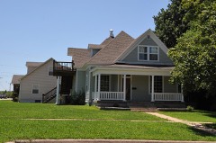 | Ralph E. Burley House | building | 1994 | 94000704 |
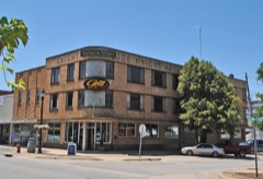 | Joe Knight Building | building | 2005 | 05000995 |
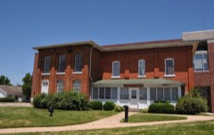 | Laclede County Jail | building | 1980 | 80002372 |
| Missouri Farmers Association - Producers Creamery Company Dairy Plant | building | 2025 | 100011654 | |
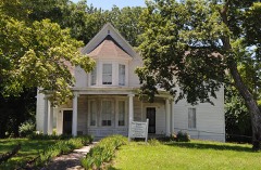 | Ploger-Moneymaker Place | building | 1982 | 82003150 |
| Rice-Stix Building, The | building | 2019 | 100004220 | |
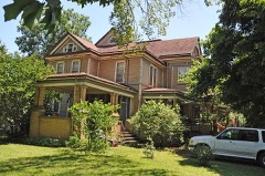 | Wallace House | building | 1984 | 84002579 |
Every wildfire the federal occurrence database records inside this county: 805 of them, burning about 31,936 acres. 3 started naturally and 362 were recorded as arson. Each settlement page carries the fires within five miles of it.
| Reported cause | Fires |
|---|---|
| Arson/incendiarism | 362 |
| Debris and open burning | 311 |
| Missing data/not specified/undetermined | 89 |
| Equipment and vehicle use | 17 |
| Smoking | 12 |
| Misuse of fire by a minor | 4 |
| Railroad operations and maintenance | 4 |
| Natural | 3 |
| Recreation and ceremony | 2 |
| Power generation/transmission/distribution | 1 |
The five largest, by the area the report gives. Four of them were set deliberately.
| Date | Cause | Size | Reported by | Name on the report |
|---|---|---|---|---|
| 17 March 2009 | Missing data/not specified/undetermined | 2,160 acres | Missouri Department of Conservation | MOUNTAIN CREEK |
| 6 March 2016 | Arson/incendiarism | 1,027 acres | Missouri Department of Conservation | 134355-05300-03062016-1200 |
| 19 September 2000 | Arson/incendiarism | 1,005 acres | Missouri Department of Conservation | not named |
| 14 March 2009 | Missing data/not specified/undetermined | 688 acres | Missouri Department of Conservation | JUNCTION 2 FIRE |
| 2 March 2012 | Missing data/not specified/undetermined | 646 acres | Missouri Department of Conservation | KINFOLK RD |
| 18 February 1994 | Arson/incendiarism | 597 acres | Missouri Department of Conservation | not named |
| 24 February 2002 | Arson/incendiarism | 497 acres | Missouri Department of Conservation | not named |
| 2 March 2012 | Missing data/not specified/undetermined | 462 acres | Missouri Department of Conservation | MAIN DR. |
Every settlement page carries the fires within five miles of it - see the settlement index below.
The NOAA Storm Events Database holds 691 reports for this county, causing 4 deaths, 26 injuries and about $128,092,050 in recorded property damage. Each settlement page carries the reports that name it.
| Kind of event | Reports |
|---|---|
| Hail | 244 |
| Thunderstorm Wind | 211 |
| Flash Flood | 110 |
| Flood | 68 |
| Tornado | 28 |
| Heavy Rain | 23 |
| Lightning | 6 |
| Wildfire | 1 |
The most serious of them, by death, then injury, then recorded damage. The accounts are quoted exactly as the forecast office filed them.
| When | Event | Place named | Harm | What the report says |
|---|---|---|---|---|
| May 2006 | Flash Flood | Sleeper | 1 killed, 2 hurt, $10,000 | Flash flooding occured over a low water crossing located along Riley Drive approximately 2.5 miles northeast of Sleeper. A van carrying eight passengers tried to cross the low water bridge and was swept off of the road. All eight people were washed downstream. Six of the passengers were washed up along a bank, while one person was wrapped around a tree. A 22 year old man was found dead approximately one mile downstream of the low water crossing. Two individuals suffered complications from hypothermia. |
| August 2007 | Flash Flood | Lebanon | 1 killed, $5,500,000 | Tropical Storm Erin remnants impacted areas of Laclede County. Flash flooding occurred county wide causing road closures to a section of Highway 32 near Pinetree Road, West Elm Road between Drury Road and Springfield Road, a section of Route BB northwest of Sleeper and north of Route F, the intersection of Highway 32 and Highway K, the intersection of Route BB and Highway F, the intersection of Route T and Highway FF, the outer road of interstate 44 at Route N, and a section of a secondary road near Sleeper. A United State Postal employee delivering rural mail drove into a washed out bridge and was swept away by flood water. |
| October 2009 | Lightning | Phillipsburg | 1 killed, $1,000 | Lightning struck a cattle rancher as he was checking his cattle. The rancher and one calf were killed from the bolt. |
| January 2020 | Flash Flood | Morgan | 1 killed | Excessive rain caused flash flooding along the Osage Fork River at Auburn Road. A 53 year old female attempted to drive across the flooded low water crossing and her vehicle became disabled. The victim exited the vehicle and attempted to swim to shore but was unsuccessful. |
| January 2008 | Tornado (EF3) | Conway | 12 hurt, $8,000,000 | This is an extension of the Webster County tornado. A National Weather Service storm survey revealed that an EF-3 tornado tracked across Laclede County. Numerous homes and outbuildings south of Lebanon were destroyed while 12 were injured. |
| February 2012 | Tornado (EF1) | Phillipsburg | 5 hurt, $750,000 | An EF-1 tornado tracked from 2 miles northwest of Philipsburg to 1 mile southeast of Lebanon. Several frame homes had roof damaged, one mobile home was destroyed, damage occurred to the roof of the Tracker Marine Boat Plant, the Lowe's Garden Center was severely damaged and numerous trees were uprooted. Several other businesses were damaged. |
| November 1960 | Tornado (F2) | not stated | 3 hurt, $25,000 | no account filed |
| April 1993 | Tornado (F0) | Competition | 2 hurt, $500,000 | A small tornado touched down destroying a mobile home and severely damaging a ranch house. Numerous outbuildings were damaged and a dump truck was rolled 300 yards. Two people were injured in the mobile home, one seriously and one minor. The county sheriff followed the tornado about 0.5 mile before it lifted. |
| May 1996 | Tornado (F1) | Conway | 1 hurt, $500,000 | no account filed |
| July 2005 | Thunderstorm Wind | Eldridge | 1 hurt, $200,000 | A severe thunderstorm produced intense straight line winds and golf ball size hail in the community of Eldridge. Several trees were downed from this storm along with a few homes sustaining structural damage. A roof was blown off of a large lumber yard. An eight year old boy was injured but not hospitalized when a tree fell into his frame home. |
| April 2026 | Hail | Conway | $76,500,000 | A hail swath from a mile to 3 miles wide began near Conway and continued to the north-northeast across Laclede County. Hail from quarters to 3 inches in size fell along a path from Conway to Phillipsburg to Eldridge as a left moving supercell moved across the County. Along the storms path, numerous homes, vehicles, businesses, equipment, crops, livestock and other structures were damaged by hail before the storm passed into southeastern Camden County. |
| April 2026 | Hail | Lebanon Jones Fld Ar | $20,000,000 | Hail from golf ball to hen egg in size was reported across portions of Lebanon including the Lebanon Airport where pictures of golf ball hail were provided. Damage occurred to homes, vehicles, equipment, outbuildings and general aviation aircraft at the airport. |
| November 1995 | Tornado (F2) | Lebanon to | $3,000,000 | A tornado skipped across the Lebanon area, destroying several buildings including the Tracker Marine plant, and heavily damaging another 30 homes. |
| April 2017 | Flash Flood | Hazelgreen | $1,000,000 | Several homes and roads sustained flood damage across Laclede County. The Gasconade River near Hazelgreen hit a new record river level. Interstate 44 near mile marker 143 was closed down due to flooding. The flooding severely damaged I-44. Bennett Spring State Park suffered some flood damage. This report will contain the total dollar estimate for flood damage to infrastructure, businesses, and homes across Laclede County. |
| December 2015 | Flash Flood | Russ | $1,000,000 | Route B was closed due to flooding at North Cobb Creek. Nearly all low water crossings across the county were flooded. There were numerous county roads that had flood damage. There was extensive damage to the campgrounds at Bennett Spring State Park including the fish hatchery and cabins. This storm report will contain the damage estimates for the entire county for this event. |
| May 2009 | Thunderstorm Wind | Conway | $1,000,000 | Widespread wind damage occurred across central and southern Laclede County. Trees, outbuildings, and power poles were the primary items that were damaged. In Conway, several homes experienced minor roof damage. Rural areas south of Lebanon experienced the most intense wind speeds. In Lebanon, a few trees were knocked over, however, structural damage was minimal. |
| March 2008 | Flash Flood | Prosperine | $1,000,000 | Four to nine inches of rain fell over Laclede County. The southeast section of the county experienced the greatest rainfall totals as widespread flooding occurred over county roads. |
| August 2013 | Flash Flood | Conway | $750,000 | This storm report will include the total estimated damages for the flooding event. Several homes had water in them along Highway J near Conway. Several high water rescues were performed. Several low water crossings and roadways were damaged due to the water throughout the county. |
| July 2015 | Flash Flood | Falcon | $500,000 | A low water crossing near Falcon was flooded. This storm report will contain the overall flood damage estimates across the entire Laclede County for this storm event. There were several episodes and heavy rainfall events which led to a compound affect to the flooding damage. Numerous roads, bridges, and low water crossings were heavily damaged. |
| February 2012 | Tornado (EF1) | Bennett Spgs | $500,000 | A brief EF1 tornado touchdown damaged 20 recreational vehicles, a pole barn and numerous trees. An antique shop and two homes also received minor roof damage. |
| December 2010 | Lightning | Lebanon | $500,000 | A lightning strike struck a large two story home just north of Lebanon. The resultant fire burned down the home and was a complete lost. |
| May 2009 | Tornado (EF2) | Jones Lebanon Arpt | $500,000 | A National Weather Service storm survey revealed that an EF-2 tornado touched down near the small community of Oakland. This tornado damaged numerous outbuildings and destroyed a mobile home. |
| January 2008 | Flash Flood | Ira | $500,000 | Training tornadic supercells caused widespread areas of flash flooding across Laclede County. Numerous roads and low water crossings were washed away. A few specific locations that received this flooding include areas along Brush Creek from Highway PP to County Road J638, a section of Highway J, a low water crossing two miles north of Sleeper, and a section of Highway 32. |
| March 2008 | Tornado (EF2) | Lebanon | $500,000 | A National Weather Service storm survey revealed that an EF-2 tornado caused damage to several homes and businesses on the north side of Lebanon. A bus was also overturned at Esther Elemetary School. |
| March 2000 | Wildfire | Countywide | $350,000 | no account filed |
| April 2026 | Hail | Lebanon Jones Fld Ar | $250,000 | Hail up to the size of golf balls was reported. Some shingle and vehicle damage was reported. |
| April 2026 | Hail | Brush Creek | $250,000 | Pictures of hail measured at 3 inches in diameter were received from the public. This hail fell in a mostly rural location though a few homes in the area received hail damage to roofs, outbuildings and equipment. A few vehicles suffered damage as well. |
| March 2025 | Tornado (EF1) | Southard | $250,000 | An EF1 tornado with peak winds around 90 mph started just west of Lynchburg and tracked northeast into far northwestern Texas County. In Laclede County, the tornado damaged numerous barns and damaged the roof of a home. Numerous trees were uprooted and damaged. The tornado then tracked northeast into Texas County. |
| July 2023 | Hail | Phillipsburg | $250,000 | Hail up to tennis balls in size was reported along I-44. Multiple vehicles suffered damage. |
| July 2023 | Hail | Phillipsburg | $250,000 | Hail up to golf balls in size was reported at Redmons Candy Factory along I-44. Multiple vehicles suffered damage. |
| April 2019 | Thunderstorm Wind | Brush Creek | $250,000 | A National Weather Service storm survey confirmed that up to 75 mph straight line winds produced a swath of damage beginning southwest of Lebanon near the intersection of Highway 32 and Macon Drive and continuing northeast into the eastern portions of Lebanon. Numerous trees were damaged, uprooted or snapped in a swath as wide as 400 yards in some locations. All trees were laying towards the northeast. A utility pole snapped and a transformer fell on a vehicle causing a car fire in the parking lot of the Elm Street Eatery. High winds and falling trees caused damage to several roofs on the south side of Lebanon. One large two foot diameter tree fell on a home causing moderate structural damage. The roof of the Ozark Hills Theater was peeled off and thrown 100 yards to the northeast. |
| July 2015 | Flood | Pease | $250,000 | Route J was closed at the Osage Fork of the Gasconade River due to flooding. This storm report will contain the overall storm damage estimates across Laclede County for this storm event. Numerous roads, bridges, and low water crossings were heavily damaged. |
| April 2013 | Hail | Conway | $250,000 | Emergency manager reported numerous windows were damaged due to golf ball size hail. I-44 was briefly shut down near mile marker 121 due to hail covered roadways. The estimated damage cost will be for the entire county for this storm in this report. |
| April 2011 | Flood | Falcon | $250,000 | Evacuations occurred at several resorts along the Gasconade River near Falcon as the river rose rapidly.||The total cost estimate for flooding damages for Laclede County for this entire episode has been included. This includes roads, bridges, and structures which were affected. |
| February 2008 | Flash Flood | Sleeper | $250,000 | Widespread flash flooding occurred across Laclede County. Specific locations that experienced this flooding included a section of Amethyst Road near its intersection with Highway J, a section of Pacific Road four miles northeast of Lebanon, the intersection of Green Hills and Park Road, low lying roads in the city of Lebanon, a section of Highway B near its intersection with Highway O, a couple of low water crossings on Highway FF near its intersection with Highway 133, a section of Highway BB two miles south of its intersection with Highway F, and several low areas along the Osage Fork River. |
| April 1982 | Tornado (F1) | not stated | $250,000 | no account filed |
| July 2023 | Hail | Ira | $125,000 | Hail up to two inches in size was reported. A few vehicles reported having cracked windshields. |
| April 2024 | Tornado (EF0) | Morgan | $100,000 | A NWS storm survey indicated an EF-0 tornado caused intermittent damage to outbuildings and trees along Highway J southeast of Phillipsburg. Some trees were uprooted and a few snapped with debris falling in a convergent pattern. Tornado width was 100 yards with maximum wind speeds of 70 to 80 mph. |
| May 2017 | Tornado (EF1) | Nebo | $100,000 | A NWS storm survey confirmed an EF-1 tornado touched down near the Falcon area in Laclede County. A house sustained moderate to major damage. There were numerous trees snapped and uprooted. Radar confirmed a well defined tornado debris signature over the path of this tornado. Estimated maximum wind speeds were up to 100 mph. |
| May 2017 | Tornado (EF1) | Brush Creek | $100,000 | The roof of a trucking business near mile mark 123 along I-44 was damaged along with multiple trucks overturned in a parking lot. This tornado uprooted numerous trees and damaged several outbuildings across rural Laclede County. |
| May 2009 | Flash Flood | Dove | $100,000 | A National Weather Service storm survey revealed that significant flash flooding occurred across much of Laclede County. Several county roads, low water crossings, and drainage culverts were washed out. |
| January 2008 | Tornado (EF2) | Phillipsburg | $100,000 | A National Weather Service storm survey revealed that an EF-2 tornado tracked across rural southwest Laclede County. The tornado was tracking directly toward Lebanon, but lifted approximately two miles out of town. One home and numerous outbuildings were destroyed. |
| March 2006 | Tornado (F0) | Competition | $80,000 | This tornado is a continuation of the Wright County tornado that crossed into Laclede County near the community of Competition. The tornado left a three mile swath of damage across rural southeast Laclede County damaging six homes and destroying none. This long tracked tornado finally lifted three miles northeast of Competition. |
| April 2024 | Tornado (EF0) | Russ | $75,000 | A NWS storm survey concluded that an EF-0 tornado caused an intermittent path of damage to outbuildings including one large equipment barn. The associated convergent debris pattern of roofing panels and varying trees extended eastward along Camelia Road between Highway H and Royal Drive. The tornado had a width of 100 yards with maximum wind speeds of 80 mph. |
| May 2021 | Thunderstorm Wind | Conway | $75,000 | A tractor trailer was blown over on Interstate 44 west bound near exit 113 Route J and Y at mile marker 113. |
| May 2024 | Hail | Lebanon | $50,000 | A swath of baseball to 3 inch size hail fell north of Lebanon. |
| May 2020 | Thunderstorm Wind | Brush Creek | $50,000 | Significant roof damage occurred to the Barber Elementary School. This damage was associated with the first of two severe storms to strike the Lebanon area. |
| May 2018 | Thunderstorm Wind | Lebanon | $50,000 | There was three commercial structures with significant sign damage. There was roof damage at several businesses including the mall. There were several homes with roof or shingle damage. There were at least two power poles blown down. |
| July 2016 | Flash Flood | Conway | $50,000 | A portion of I-44 was briefly flooded in spots between Mile Markers 111 to 117. The interstate was briefly closed due to an undisclosed number of crashes. There were three swift water rescues reported by emergency management. |
| June 2015 | Flash Flood | Lebanon | $50,000 | There was a high water rescue at Omega Street and Dove KOA Campground. This storm report will contain the overall storm damage estimates across the entire Laclede County for this storm event. Several roads, bridges, and low water crossings were damaged. |
| March 2012 | Flood | Falcon | $50,000 | Flooding occurred along the Gasconade River in southeastern Laclede County. Water rose into a home near the river and Highway 35 south of Falcon. Evacuations of a nearby resort occurred due to rising river levels. |
| April 1994 | Tornado (F1) | Lebanon | $50,000 | The Sheriff's office reported signs blown down, flags ripped from poles, and power lines down. Also, an airplane was flipped over at a nearby airport. |
| February 2023 | Thunderstorm Wind | Jones Lebanon Arpt | $45,000 | Several large trees were reported down with large limbs reported down on a home. A barn suffered significant damage from straight line winds. |
| September 2020 | Thunderstorm Wind | Bennett Spgs | $40,000 | Multiple power outages were reported as power lines and poles were downed by high winds. |
| April 2000 | Thunderstorm Wind | Lebanon | $35,000 | no account filed |
| May 2020 | Thunderstorm Wind | Sleeper | $30,000 | Several large signs were blown down along Interstate 44. |
| May 2008 | Lightning | Brush Creek | $30,000 | A house caught on fire as a result of a lightning strike. The house was heavily damaged from the fire. |
| July 1999 | Thunderstorm Wind | Lebanon | $30,000 | no account filed |
| May 2024 | Hail | Lebanon | $25,000 | Report of baseball size hail. |
| August 2022 | Thunderstorm Wind | Lebanon | $25,000 | Thunderstorm winds caused significant damage to a barn and moderate damage to the roof of a home. |
The Survey's mineral resources record lists 36 workings inside this county. 1 still produces and 35 are closed or unrecorded. Each settlement page carries the workings within five miles of it.
| Commodity | Workings |
|---|---|
| Stone, Crushed/Broken | 22 |
| Sand and Gravel, Construction | 8 |
| Iron | 3 |
| Zinc | 1 |
| Lead, Zinc | 1 |
| Zinc, Lead | 1 |
The least common of them first, because a county's hundredth gravel pit says nothing its first ten did not.
| Where | Site | Commodity | Status | Recorded |
|---|---|---|---|---|
| Unknown - Lead-Zinc | Lead, Zinc | Past Producer | ||
| Unknown - Zinc | Zinc | Past Producer | ||
| Wheeler Mines | Zinc, Lead | Past Producer | ||
| Ambrose Clark Bank | Iron | Past Producer | ||
| Gregory Bank | Iron | Past Producer | ||
| Unknown - Iron | Iron | Past Producer | ||
| Unknown - S&G | Sand and Gravel, Construction | Past Producer | ||
| Unknown - S+G | Sand and Gravel, Construction | Past Producer | ||
| Unknown - S+G | Sand and Gravel, Construction | Past Producer | ||
| Unknown - S+G | Sand and Gravel, Construction | Past Producer | ||
| Unknown - S+G | Sand and Gravel, Construction | Past Producer | ||
| Unknown - S+G | Sand and Gravel, Construction | Past Producer | ||
| Unknown - S+G | Sand and Gravel, Construction | Past Producer | ||
| Unknown - S+G | Sand and Gravel, Construction | Past Producer | ||
| Baumgarten Quarry | Stone, Crushed/Broken | Past Producer | ||
| Lebanon Qsuarry | Stone, Crushed/Broken | Unknown | ||
| Mayfields Quarry | Stone, Crushed/Broken | Past Producer | ||
| Stony Point Quarry | Stone, Crushed/Broken | Past Producer | ||
| Unknown - Ls | Stone, Crushed/Broken | Past Producer | ||
| Unknown - Ls | Stone, Crushed/Broken | Past Producer | ||
| Unknown - Ls | Stone, Crushed/Broken | Past Producer | ||
| Unknown - Ls | Stone, Crushed/Broken | Past Producer | ||
| Unknown - Ls | Stone, Crushed/Broken | Past Producer | ||
| Unknown - Ls | Stone, Crushed/Broken | Past Producer | ||
| Unknown - Ls | Stone, Crushed/Broken | Past Producer | ||
| Unknown - Ls | Stone, Crushed/Broken | Past Producer | ||
| Unknown - Ls | Stone, Crushed/Broken | Past Producer | ||
| Unknown - Ls | Stone, Crushed/Broken | Past Producer | ||
| Unknown - Ls | Stone, Crushed/Broken | Past Producer | ||
| Unknown - Ss | Stone, Crushed/Broken | Past Producer | ||
| Unknown - Ss | Stone, Crushed/Broken | Past Producer | ||
| Unknown - Ss | Stone, Crushed/Broken | Past Producer | ||
| Unknown - Ss | Stone, Crushed/Broken | Past Producer | ||
| Unknown - Ss | Stone, Crushed/Broken | Past Producer | ||
| Unknown - Ss | Stone, Crushed/Broken | Past Producer | ||
| Willard Quarry & Plant | Stone, Crushed/Broken | Producer |
Named settlements recorded in the Geographic Names Information System, each with the topographic sheets covering it. Villages, hamlets and abandoned places alike. Each is shown with the nearest named watercourse or landform and the survey quadrangle it falls on.
Gasconade township · 65534 · On Nelson Creek · Brownfield quadrangle
17 sheets, 1943 to 2004
Spring Hollow township · 65536 · Lebanon quadrangle
14 sheets, 1941 to 1982
No longer a settlement
Spring Hollow township · 65536 · Near Danceyard Hollow · Bennett Springs quadrangle
14 sheets, 1939 to 1982
Eldridge township · 65463 · On Prairie Branch · Eldridge East quadrangle
14 sheets, 1933 to 1982
Gasconade township · 65470 · Near Wilcox Hollow · Drew quadrangle
17 sheets, 1943 to 2004
Franklin township · 65470 · On Sutton Branch · Competition quadrangle
17 sheets, 1931 to 2004
Washington township · 65536 · Near Sharpe Hollow · Russ quadrangle
14 sheets, 1941 to 1982
Gasconade township · 65470 · Near Big Sleepy Hollow · Drew quadrangle
17 sheets, 1943 to 2004
May/Smith township · 65556 · Near Wilson Hollow · Richland quadrangle
14 sheets, 1943 to 1982
Eldridge township · 65536 · Near Mill Hollow · Eldridge West quadrangle
16 sheets, 1934 to 1982
No longer a settlement
May/Smith township · 65556 · On Similin Creek · Drynob quadrangle
17 sheets, 1943 to 2004
May/Smith township · 65556 · On Prairie Creek · Richland quadrangle
14 sheets, 1943 to 1982
Phillipsburg township · 65722 · Phillipsburg quadrangle
14 sheets, 1939 to 1982
No longer a settlement
Eldridge township · 65463 · Near Clark Hollow · Eldridge West quadrangle
16 sheets, 1934 to 1982
Osage township · 65536 · On South Fork North Cobb Creek · Oakland quadrangle
14 sheets, 1941 to 1982
Eldridge township · 65463 · Near Fishtrap Hollow · Eldridge West quadrangle
16 sheets, 1934 to 1982
No longer a settlement
Eldridge township · 65463 · On Sweet Hollow Creek · Eldridge West quadrangle
16 sheets, 1934 to 1982
No longer a settlement
Eldridge township · 65463 · Near Tom Hollow · Eldridge West quadrangle
16 sheets, 1934 to 1982
No longer a settlement
The vanished settlements of Laclede County: the places named above that are no longer on the map.