 Block
From the record
9 National Register listings published here.
Sources: the National Register database, National Park Service
60 topographic sheets cover 24 settlements here, and 9 properties are on the National Register of Historic Places.
9 National Register listings published here.
Sources: the National Register database, National Park Service
Every property in this county listed on the National Register of Historic Places, with the year it was listed and the federal nomination document.
| Photograph | Property | Type | Listed | Reference |
|---|---|---|---|---|
| James B. Brown House | building | 1984 | 84002603 | |
| John Garth House | building | 1977 | 77000813 | |
| Greenlawn Methodist Church and Cemetery | building | 2007 | 07000569 | |
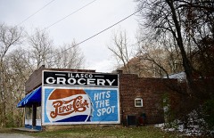 | Ilasco Historic District | district | 2016 | 16000343 |
 | Lock and Dam No. 22 Historic District | district | 2004 | 04000182 |
 | Ralls County Courthouse and Jail-Sheriff's House | building | 1972 | 72000728 |
 | Saverton School | building | 1998 | 98001505 |
 | St. Paul Catholic Church | building | 1979 | 79001392 |
 | St. Peter's Catholic Church | building | 1980 | 80002392 |
Every wildfire the federal occurrence database records inside this county: 60 of them, burning about 1,642 acres. None started naturally and 2 were recorded as arson. Each settlement page carries the fires within five miles of it.
| Reported cause | Fires |
|---|---|
| Debris and open burning | 37 |
| Missing data/not specified/undetermined | 15 |
| Equipment and vehicle use | 3 |
| Arson/incendiarism | 2 |
| Recreation and ceremony | 1 |
| Smoking | 1 |
| Fireworks | 1 |
The five largest, by the area the report gives. One of them was set deliberately.
| Date | Cause | Size | Reported by | Name on the report |
|---|---|---|---|---|
| 31 October 1999 | Arson/incendiarism | 835 acres | Missouri Department of Conservation | not named |
| 31 October 1999 | Missing data/not specified/undetermined | 200 acres | Missouri Department of Conservation | not named |
| 5 November 1999 | Missing data/not specified/undetermined | 150 acres | Missouri Department of Conservation | not named |
| 8 March 2020 | Fireworks | 60 acres | Missouri Department of Conservation | 190315-06417-03082020-1635 |
| 14 August 1999 | Debris and open burning | 55 acres | Missouri Department of Conservation | not named |
| 21 March 1997 | Debris and open burning | 40 acres | Missouri Department of Conservation | not named |
| 14 February 1994 | Debris and open burning | 40 acres | Missouri Department of Conservation | not named |
| 15 November 1996 | Equipment and vehicle use | 25 acres | Missouri Department of Conservation | not named |
Every settlement page carries the fires within five miles of it - see the settlement index below.
The NOAA Storm Events Database holds 224 reports for this county, causing no deaths, 14 injuries and about $1,712,650 in recorded property damage. Each settlement page carries the reports that name it.
| Kind of event | Reports |
|---|---|
| Thunderstorm Wind | 109 |
| Hail | 73 |
| Flash Flood | 17 |
| Tornado | 12 |
| Flood | 10 |
| Lightning | 3 |
The most serious of them, by death, then injury, then recorded damage. The accounts are quoted exactly as the forecast office filed them.
| When | Event | Place named | Harm | What the report says |
|---|---|---|---|---|
| August 1985 | Thunderstorm Wind | not stated | 13 hurt | no account filed |
| August 1996 | Lightning | Center | 1 hurt | no account filed |
| July 2021 | Thunderstorm Wind | Rensselaer | $1,300,000 | An NWS storm survey discovered a macroburst that first initiated to the north of Rensselaer, MO. This macroburst caused extensive tree damage in town, especially on the western side of Rensselaer where several large branches and trees were snapped or uprooted and a few roofs sustained damage. Winds in this area were determined to be around 80 mph. The large swath of damaging winds then pushed south towards Mark Twain State Park. Extensive tree damage was noted in the state park. In addition, the Blackjack Marina sustained quite a bit damage from straight line winds around 80 mph. These winds were strong enough to cause damage to several boats, damage to the metal roofing of the marina, and the winds were even able to pull part of the marina off its mooring. The dollar amount damage to the marina is estimated to be around a million dollars. The worst of the damage occurred to the south of the marina in the town of Perry, MO. Extensive tree damage was noted in this area along with some damage to roofs and siding to a number of residences. The degree of tree and structural damage was consistent with fairly widespread 80 mph winds across town, with localized areas of 90 mph present in some of the observed damage. Straight line wind damage continued to the south of Perry, but it became less intense and more scattered in nature south of town. No deaths or injuries were reported. |
| July 2008 | Flood | Hatch | $200,000 | Rainfall of 7 - 10 inches fell across North Central Missouri causing flooding at Mark Twain Lake and along the Salt River. This represented the first flooding of the Salt River since the completion of Clarence Cannon Dam which created Mark Twain Lake in 1984. The crest at New London represented the 8th highest crest of record, resulting in the flooding of numerous farm houses and state roads. Thirty families had to be evacuated from their homes due to the flooding. At least 30 roads had to be closed. Agricultural losses were estimated at $10 million. Initial public assistance damage estimates were put at $200,000. |
| June 2008 | Flood | Ilasco | $55,000 | The Mississippi River at Saverton, MO crested at 27.97 feet on 6/18/2008. This is the second highest crest ever recorded. Ten homes in the Saverton area were flooded. The lock and dam at Saverton was over topped by the river. Highway 79 was closed at a couple of locations. There were no other towns affected as the rest of the county along the river is open flood plain. The County estimated public infrastructure damage at $55,000. No agricultural losses were reported. |
| June 2022 | Thunderstorm Wind | Center | $50,000 | Widespread wind damage across Ralls County, especially in Center, New London and portions of Hannibal in northeastern Ralls County. There were numerous tree limbs blown down as well as power lines. In Center, a tree was blown down onto a house causing moderate roof damage. In New London, another large tree was blown down onto a house causing moderate roof damage. A tree was blown down onto Highway HH north of New London. |
| May 2008 | Tornado (EF0) | Center | $30,000 | A tornado initially formed near the intersection of Highway 19 and County Road 209. Power pole and tree damage was noted at this location. The tornado moved east northeast and caused more tree damage about 3/4 mile south of Highway 19 and Clarence Cannon Lane. The tornado crossed Highway P about 1 mile south of Center. Large power poles were bent over about 20 degrees at this location. The tornado moved east northeast and damaged a modular home and a machine shed near Kingbird and Vesper Drive. About 100 yards east of this location a mobile home was turned onto its side. |
| April 1975 | Tornado (F2) | not stated | $25,000 | no account filed |
| February 2000 | Thunderstorm Wind | Center | $20,000 | no account filed |
| June 2000 | Tornado (F0) | Rensselaer | $10,000 | The County Sheriff reported a brief tornado west of Rensselaer. Trees were uprooted and a barn heavily damaged. |
| May 1995 | Thunderstorm Wind | New London | $7,500 | Strong winds uprooted trees and destroyed a chicken coop along Highway 61. Closer to New London, the county sheriff reported many large trees blown down. |
| June 1994 | Thunderstorm Wind | New London | $5,000 | Several large trees were blown down along Highway 19 northeast of Center. Trees were also knocked down in New London with one damaging the corner of a house. Rainfall up to four inches was reported by a local newspaper. |
| June 1994 | Thunderstorm Wind | Center | $5,000 | The county sheriff reported trees and power poles down in Center. A billboard sign was also blown down north of New London along Highway 61. |
| October 2021 | Thunderstorm Wind | New London | $1,000 | Thunderstorm winds blew down a large tree near the Ralls County Sheriff's office in New London. |
| April 2013 | Flood | Ilasco | $1,000 | The Mississippi River rose to major flood levels along the border of Ralls County. The river crested on the 21st through 22nd, but continued above flood stage into May. Damage was limited to a few roads closed and flooding of agricultural lowlands. |
| May 2013 | Flood | Ilasco | $1,000 | no account filed |
| June 1994 | Thunderstorm Wind | Perry | $500 | The county sheriff reported large trees down three to four miles north of Perry on County Road J. |
| June 1994 | Thunderstorm Wind | New London | $500 | The county sheriff reported trees and power poles down in Center. A billboard sign was also blown down north of New London along Highway 61. |
| June 1994 | Thunderstorm Wind | Center | $500 | Several large trees were blown down along Highway 19 northeast of Center. Trees were also knocked down in New London with one damaging the corner of a house. Rainfall up to four inches was reported by a local newspaper. |
| May 1973 | Tornado (F1) | not stated | $250 | no account filed |
| May 1995 | Thunderstorm Wind | New London | $200 | Strong winds uprooted trees and destroyed a chicken coop along Highway 61. Closer to New London, the county sheriff reported many large trees blown down. |
| July 1995 | Thunderstorm Wind | Center | $200 | Power lines and poles were blown down east of Center. |
| June 2025 | Flood | Flinthill | - | Heavy rain caused waters on Camp Creek to rise out of their banks. This resulted in flooding at Camp Creek Lane and Highway O where a police truck was moved by flood water. |
| July 2025 | Thunderstorm Wind | Saverton | - | Thunderstorm winds knocked down a large tree which blocked Highway 79 at an unknown location. |
| July 2023 | Thunderstorm Wind | Saverton | - | Thunderstorm winds blew down several large tree limbs and power lines onto Highway 79 just southwest of Saverton. |
| June 2023 | Thunderstorm Wind | New London | - | Thunderstorm winds blew down several large trees, numerous tree limbs and several power lines, especially between New London and Old Highway 79. Some of the fallen trees blocked Highway V just east of New London. |
| April 2021 | Thunderstorm Wind | Center | - | Thunderstorm winds damaged a large trampoline. |
| April 2021 | Thunderstorm Wind | New London | - | Thunderstorm winds blew over several large trees onto Buford Cave Lane. |
| June 2021 | Flash Flood | Spalding | - | Up to five inches of rain fell in about a two hour period causing flash flooding. Numerous roads were flooded including Highway A in New London, U.S. Highway 61 south of New London, and the intersection of U.S. Highway 61 and Highway 19. Also, Highway 19 just southwest of Center and the intersection of Kingbird Lane and Highway F. |
| June 2021 | Thunderstorm Wind | Perry | - | Thunderstorm winds blew down numerous tree limbs around town. |
| June 2021 | Thunderstorm Wind | Ilasco | - | Thunderstorm winds blew down a large tree onto a house causing major damage to the walls, which were buckling under the weight of the fallen tree. Several windows were broken on the house as well. |
| December 2021 | Thunderstorm Wind | New London | - | Thunderstorm winds snapped a telephone pole in town. |
| June 2020 | Thunderstorm Wind | Perry | - | Thunderstorm winds blew down a large tree onto Highway B south of Perry. |
| May 2020 | Flash Flood | New London | - | Up to 3 inches of rain fell in about a two hour period over portions of Ralls County causing flash flooding. Highway F, just north of intersection with Highway C, was flooded where it crosses over Spencer Creek. Also, Highway 19 between Perry and Center was closed due to flooding. |
| July 2020 | Flash Flood | Center | - | Up to three inches of rain caused flash flooding in and around the Spalding area. Water two to three feet deep was over Highway M about 3.5 miles west of U.S. Highway 61. Also, a vehicle was stuck in water up to 18 inches deep on Highway H just south of intersection with Highway A. |
| November 2020 | Thunderstorm Wind | Ilasco | - | Thunderstorm winds blew down a 12 inch diameter tree blocking New London Gravel Road. |
| April 2019 | Hail | Joanna | - | A wide swath of large hail fell across portions of Ralls County, from the Mark Twain Lake area eastward to Center. The largest hail reported was golf ball sized. |
| April 2019 | Thunderstorm Wind | Center | - | Thunderstorm winds blew down numerous large tree limbs around town. |
| July 2019 | Thunderstorm Wind | New London | - | Thunderstorm winds blew down a 12 inch diameter tree in town. |
| June 2019 | Thunderstorm Wind | Flinthill | - | Thunderstorm winds blew down numerous large tree limbs. |
| June 2019 | Thunderstorm Wind | Perry | - | Thunderstorm winds blew down trees across multiple roads in Ralls County, including near Ilasco. |
| June 2019 | Thunderstorm Wind | Liberty Hall | - | Thunderstorm winds blew down a large tree onto Highway 154 just east of intersection with Idaho Road. |
| June 2019 | Thunderstorm Wind | Liberty Hall | - | Thunderstorm winds blew down a large tree onto Highway 154 just east of intersection with Idaho Road. |
| May 2019 | Thunderstorm Wind | Liberty Hall | - | Thunderstorm winds blew over portions of an field irrigator, bent a section of it and drove another portion of it into the ground. |
| June 2018 | Thunderstorm Wind | Saverton | - | Thunderstorm winds blew down a tree across a road just south southwest of Saverton. |
| March 2018 | Flash Flood | Hutchinson | - | Between 2 and 4 inches of rain fell in a short amount of time causing flash flooding. Several roads were flooded including the intersection of Highway F and Seely Lane and at the intersection of Highways F and AB. |
| May 2018 | Thunderstorm Wind | Hunington | - | Thunderstorm winds blew down several large trees between Huntington, Rensselaer and the southern sections of Hannibal. Some of the trees fell onto Highway DD and Highway O. |
| March 2017 | Thunderstorm Wind | Center | - | Thunderstorm winds blew down numerous large tree limbs and a couple of street signs. |
| March 2017 | Tornado (EF0) | Perry | - | A local storm chaser documented multiple brief touchdowns of a very weak EF0 tornado along an almost seven mile path extending from one mile north of Perry, MO to one mile south of Landing, MO near Missouri Highway J. There was no visible damage observed from this tornado. The total amount of time that the funnel was in contact with the ground was estimated to be less than one minute. |
| July 2016 | Thunderstorm Wind | New London | - | Thunderstorm winds bent two power poles over Highway 19 just southwest of New London, blocking the roadway. |
| July 2016 | Thunderstorm Wind | New London | - | Thunderstorm winds blew down several power lines around town. |
| July 2016 | Thunderstorm Wind | Perry | - | A line of severe storms moved through Ralls County. Numerous trees, tree limbs and power lines were blown down across the county, especially in Perry, Center and New London. |
| July 2014 | Thunderstorm Wind | Flinthill | - | Thunderstorm winds blew down several large tree limbs as well as a stop sign at the intersection of U.S. Highway 61 and Highway HH. |
| July 2014 | Thunderstorm Wind | Center | - | Thunderstorm winds blew down numerous power lines between Center and New London. |
| April 2013 | Thunderstorm Wind | Hassard | - | Two grain bins, located on Highway J just north of Hazard Lane, in far northwestern Ralls County, sustained minor damage. The grain elevator sustained minor damage as well. There was minor tree limb damage that extended for about a mile south of the grain bins. |
| April 2013 | Thunderstorm Wind | Rensselaer | - | Thunderstorm winds blew a wooden swing set approximately 100 yards. |
| May 2013 | Thunderstorm Wind | Hassard | - | Thunderstorm winds blew down numerous large tree limbs along Highway J and Highway A. |
| May 2013 | Flash Flood | Ilasco | - | Up to three inches of rain fell in a short amount of time causing flash flooding. Bear Creek was running out of its banks and flooding a mobile home park on the south side of Hannibal just off of Warren Barrett Drive on Ledbetter Lane. Also, Highway 79 near intersection with Monkey Run Trail had water flowing over it. |
| June 2013 | Flood | Ilasco | - | The Mississippi River started June in flood and hit major flood levels cresting on the 1st. The river fell below flood stage on the 21st. Damage was limited to some flooded roads and flooded farmland. |
| June 2011 | Thunderstorm Wind | Spalding | - | Thunderstorm winds blew down several large trees onto Highway HH about 3 miles east southeast of Rensselaer. Further to the east on Trabue Lane, about a mile west of U.S. Highway 61, a house had a large section of shingles removed. |
The Survey's mineral resources record lists 34 workings inside this county. 8 still produce and 26 are closed or unrecorded. Each settlement page carries the workings within five miles of it.
| Commodity | Workings |
|---|---|
| Stone, Crushed/Broken | 26 |
| Sand and Gravel, Construction | 4 |
| Salt | 2 |
| Aluminum, Iron, Silica, Titanium, Water, Free | 1 |
| Clay | 1 |
The least common of them first, because a county's hundredth gravel pit says nothing its first ten did not.
| Where | Site | Commodity | Status | Recorded |
|---|---|---|---|---|
| Hannibal Plant - Shale Pit | Clay | Producer | ||
| Hudson Shale | Aluminum, Iron, Silica, Titanium, Water, Free | Occurrence | ||
| Freemores Lick | Salt | Past Producer | ||
| Unknown | Salt | Past Producer | ||
| Edward Cooper S+G Pit | Sand and Gravel, Construction | Past Producer | ||
| Unknown | Sand and Gravel, Construction | Past Producer | ||
| Unknown | Sand and Gravel, Construction | Past Producer | ||
| Unknown | Sand and Gravel, Construction | Past Producer | ||
| Al Plant - Quarry & Plant | Stone, Crushed/Broken | Producer | ||
| Burlington Mine | Stone, Crushed/Broken | Producer | ||
| Central Stone #1 Huntington Quarry | Stone, Crushed/Broken | Producer | ||
| Central Stone #9 | Stone, Crushed/Broken | Producer | ||
| Central Stone Co. Quarry #6 | Stone, Crushed/Broken | Producer | ||
| Central Stone Plant #1 | Stone, Crushed/Broken | Producer | ||
| Central Stone Quarry # 5 | Stone, Crushed/Broken | Past Producer | ||
| Clayton's Quarry | Stone, Crushed/Broken | Past Producer | ||
| Fullgrat Quarry | Stone, Crushed/Broken | Past Producer | ||
| Megowan Quarry | Stone, Crushed/Broken | Past Producer | ||
| Odell Quarry | Stone, Crushed/Broken | Past Producer | ||
| Sss Quarry # 2 - New London | Stone, Crushed/Broken | Producer | ||
| Unknown | Stone, Crushed/Broken | Past Producer | ||
| Unknown | Stone, Crushed/Broken | Past Producer | ||
| Unknown | Stone, Crushed/Broken | Past Producer | ||
| Unknown | Stone, Crushed/Broken | Past Producer | ||
| Unknown | Stone, Crushed/Broken | Past Producer | ||
| Unknown | Stone, Crushed/Broken | Past Producer | ||
| Unknown | Stone, Crushed/Broken | Past Producer | ||
| Unknown | Stone, Crushed/Broken | Past Producer | ||
| Unknown | Stone, Crushed/Broken | Past Producer | ||
| Unknown | Stone, Crushed/Broken | Past Producer | ||
| Unknown | Stone, Crushed/Broken | Past Producer | ||
| Unknown | Stone, Crushed/Broken | Past Producer | ||
| Unknown | Stone, Crushed/Broken | Past Producer | ||
| Unknown | Stone, Crushed/Broken | Past Producer |
Named settlements recorded in the Geographic Names Information System, each with the topographic sheets covering it. Villages, hamlets and abandoned places alike. Each is shown with the nearest named watercourse or landform and the survey quadrangle it falls on.
Saline township · 63436 · Near Johnson Hollow · Center quadrangle
12 sheets, 1903 to 1991
Salt River township · 63352 · On Middle Lick Creek · Hutchison quadrangle
16 sheets, 1890 to 1986
Clay township · 63401 · On Crooked Creek · Hannibal West quadrangle
17 sheets, 1932 to 1986
No longer a settlement
Saverton township · 63401 · On Marble Creek · Hannibal East quadrangle
17 sheets, 1932 to 1993
Saline township · 63456 · On Indian Creek · Clarence Cannon Dam quadrangle
12 sheets, 1903 to 1990
Jasper township · 63436 · On Hippo Branch · Spencerburg quadrangle
17 sheets, 1890 to 1986
Saverton township · 63401 · On Marble Creek · Hannibal East quadrangle
17 sheets, 1932 to 1993
Spencer township · 63459 · On Turkey Creek · New London quadrangle
17 sheets, 1932 to 1991
Saverton township · 63459 · Near Epperson Island · Hannibal SE quadrangle
18 sheets, 1932 to 1991
Saverton township · 63467 · On Hascall Creek · Hannibal East quadrangle
17 sheets, 1932 to 1993
Salt River township · 63462 · On Little Indian Creek · Clarence Cannon Dam quadrangle
12 sheets, 1903 to 1990
The vanished settlements of Ralls County: the places named above that are no longer on the map.