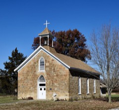
Listed on the National Register of Historic Places in 2007.
From the record
“Greenlawn Methodist Church and Cemetery, also known as Scobee Chapel and Greenlawn Memorial Chapel, is a historic Methodist church and cemetery located near Perry, Ralls County, Missouri. The church was built about 1883, and is a one-story, rectangular frame building on a stone pier foundation.”
Wikipedia article Greenlawn Methodist Church and Cemetery, CC BY-SA 4.0.
One of 9 National Register listings published here for Ralls County · listed in 2007 · category: Building.
National Register reference number.07000569- the number the National Park Service assigned this property when it was listed, and the key its nomination file is catalogued under at the National Archives.
Fires near this property
3 since 1996
Regional context, not property-specific
evidence. The
federal wildfire occurrence database
lists 3 fires within 5 miles of Greenlawn Methodist Church and Cemetery
between 1996 and 1997, burning about 43 acres in total. None started naturally. None was recorded as arson.
Distance is straight-line from the map coordinates, so a fire counted
here may appear on a neighbouring settlement's page as well.
Reported cause
Fires
Debris and open burning
2
Missing data/not specified/undetermined
1
The most recent of
them, most recent first, with the day each was reported and the service
that recorded it.
Regional context, not property-specific
evidence. The federal mineral resources record lists
2 workings within 5 miles of Greenlawn Methodist Church and Cemetery: 1 producer, 1 past producer.
1 still produces. What was taken out: Stone, Crushed/Broken. Distance is straight-line from the
map coordinates, so a quarry counted here may appear on a neighbouring
settlement's page as well.
Regional context, not property-specific
evidence. The National Weather Service names
Perry, the town this property stands in, in 34 storm reports between 1994 and 2021: 16 thunderstorm wind, 16 hail, 2 tornado.
No death or injury is recorded in these reports. Each account below is quoted exactly as the forecast office
filed it, from the NOAA Storm Events Database, and each date
opens the federal record of that event.
A local storm chaser documented multiple brief touchdowns of a very weak EF0 tornado along an almost seven mile path extending from one mile north of Perry, MO to one mile south of Landing, MO near Missouri Highway J. There was no visible damage observed from this tornado. The total amount of time that the funnel was in contact with the ground was estimated to be less than one minute.
A line of severe storms moved through Ralls County. Numerous trees, tree limbs and power lines were blown down across the county, especially in Perry, Center and New London.
The tornado formed around 425 pm CDT 1.5 miles north of Clarence Cannon Dam on County Highway J. Three businesses at this location sustained damage. A convenience store suffered minor exterior damage to shingles, siding, windows and trim. A pole barn suffered substantial roof damage from an airborne camper that was blown from an outdoor storage lot to the east. Damage from this building was scattered 200-300 feet. Four campers in the outdoor lot were damaged with two of these being completely destroyed. Two boats were also flipped over. A camper dealership was located directly across highway J. This building sustained extensive damage. An attached service bay to the south was completely leveled. The second story above the office was obliterated with only the west facing wall left standing. At least 30 campers sustained some type of damage. Eight to ten were completely destroyed. Some of the camper frames were found 150 to 200 feet north of their initial positions. Debris from this area was scattered over 1/4 mile away. Three 1x3 inch boards were found stuck in the dealerships hard packed gravel lot. There was also substantial tree damage. Cedar trees with a diameter of 12 to 15 inches were snapped off at ground level bordering the dealership lot. The tornado was 350 yards wide at this location and produced F2 damage. The tornado continued northeast for 1.3 miles and damaged a pole barn on Clinton Road. The pole barn suffered light roof and trim damage. Southwest of the pole barn, an isolated cedar tree 1.5 to 2 feet in diameter was snapped off 3 feet above the ground. The top portion of the tree was found 150 feet to the northeast. The tornado was 100 yards at this location and produced F1damage. The tornado continued 1.7 miles northeast passing through the Salt River Valley. On township road CC, there was a 2 foot square metal sign buried 4-6 inches into a tilled field. At this location, the tornado was 40 yards wide and produced F0 damage. The tornado dissipated just northeast of this location.
Thunderstorm wind gusts caused damage in Perry. Trees and power lines were downed and some utility poles broken. Some storage sheds at homes were destroyed and a trailer at a construction site was destroyed.
Hail reached golf ball-size hail but no damage was reported by the local police department or the Missouri Highway Patrol. The hail fell for several minutes.
No historic map-sheet match is published
for this property yet. That does not mean no map exists. This record needs
a coordinate-quality review before it can be joined to a sheet boundary.
Browse the county's mapped places while that work is
pending.
Listed places nearby
1 within 8 miles
Other National Register properties close
enough to walk or drive between, ordered by distance from this one. Both
positions come from the same geocoding pass that matched these properties
to their map sheets.
Listing record. National Park Service National Register of Historic Places, listed-properties dataset, current to 2026-05-22.
Map join. Address geocoded through the United States Census geocoder, then tested against the published boundary of every sheet in the USGS Historical Topographic Map Collection.
How this page is made. Listing fields come from federal records; map-sheet coverage is a labelled coordinate-to-boundary calculation, not a source-field claim.
Wildfire. Short, Karen C. 2022. Spatial wildfire occurrence data for the United States, 1992-2020 [FPA_FOD_20221014]. 6th Edition. Fort Collins, CO: Forest Service Research Data Archive. https://doi.org/10.2737/RDS-2013-0009.6 Collected with United States Government funding and usable without additional permissions or fees.
Mines and quarries. USGS Mineral Resources Data System (MRDS) https://mrdata.usgs.gov/mrds/ A work of the United States government, no copyright under 17 U.S.C. 105.
Storms. NOAA National Centers for Environmental Information, Storm Events Database https://www.ncei.noaa.gov/stormevents/ A work of the United States government, no copyright under 17 U.S.C. 105. Narratives are quoted verbatim from the National Weather Service report and are not edited or summarised.
 Block