BlockBefore
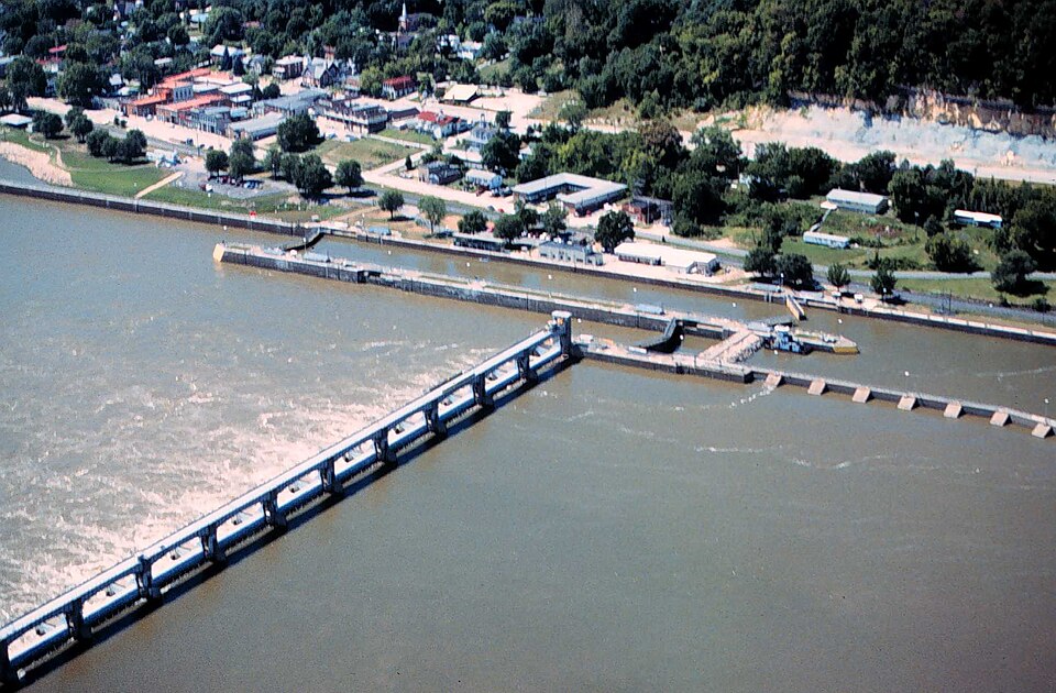
Photograph of Lock and Dam No. 24
Photograph by USGS, Public domain. Via Wikimedia Commons.

Lock and Dam No. 24 Historic District

Listed on the National Register of Historic Places in 2004.

From the record

One of 21 National Register listings published here for Pike County · listed in 2004 · category: District.

Sources: the case file at the National Archives · the National Register database, National Park Service · the Wikipedia article
The listing

  • Address. 350 N. First St., Clarksville, 63336
  • When was it listed? March 2004
  • Category. district
  • Township. Calumet township
  • National Register reference number. 04000183 - the number the National Park Service assigned this property when it was listed, and the key its nomination file is catalogued under at the National Archives.

Mines and quarries near this property

6 within 5 miles

Regional context, not property-specific evidence. The federal mineral resources record lists 6 workings within 5 miles of Lock and Dam No. 24 Historic District: 5 past producers, 1 producer. 1 still produces. What was taken out: Stone, Crushed/Broken. Distance is straight-line from the map coordinates, so a quarry counted here may appear on a neighbouring settlement's page as well.

Where SiteCommodity StatusRecorded
Clifford QuarryStone, Crushed/BrokenPast Producer
N392229Stone, Crushed/BrokenProducer
Oakwood QuarryStone, Crushed/BrokenPast Producer
UnknownStone, Crushed/BrokenPast Producer

Every working recorded in Pike County

Storms near this property

9 since 1996

Regional context, not property-specific evidence. The National Weather Service names Clarksville, the town this property stands in, in 9 storm reports between 1996 and 2018: 4 hail, 3 thunderstorm wind, 1 flood, 1 tornado. No death or injury is recorded in these reports. Each account below is quoted exactly as the forecast office filed it, from the NOAA Storm Events Database, and each date opens the federal record of that event.

WhenEvent Place namedHarm What the report says
May 2018Thunderstorm WindClarksville-Thunderstorm winds blew down several power lines as well as trees. The trees were blown down onto Highway W on south side of Clarksville.
April 2011Tornado (EF0)Clarksville-The tornado touched down in the south side of Clarksville, damaging trees, removing shingles from several homes, and damaging fencing and several carports in the area. Several windows on the east side of the Catholic Church were also broken. Witnesses report that after the tornado exited Clarksville the funnel began to cross the Mississippi River, but dissipated before crossing into Calhoun County, Illinois. Total length of this tornado was 0.4 miles, with a maximum width of about 50 yards. The damage in this area was rated EF0, with winds of 70 to 75 mph.
August 2007FloodClarksville-Heavy rain upstream caused minor flooding on the Mississippi River. At Clarksville and Louisiana, the river peaked about 2 feet over flood stage and was still in flood when the month ended.
September 2003Thunderstorm WindClarksville-Amateur radio spotters reported trees down on Highway 79 north of Clarksville.
July 2003Thunderstorm WindClarksville-A construction crane at Lock and Dam 24 was blown over by thunderstorm wind gusts. A shed and fence were also damaged when the crane fell.
April 2011HailClarksville-no account filed
March 2006HailClarksville-no account filed
April 1996HailClarksville-no account filed

Every storm recorded in Pike County

Map coverage status

No historic map-sheet match is published for this property yet. That does not mean no map exists. This record needs a coordinate-quality review before it can be joined to a sheet boundary. Browse the county's mapped places while that work is pending.

Listed places nearby

5 within 8 miles

Other National Register properties close enough to walk or drive between, ordered by distance from this one. Both positions come from the same geocoding pass that matched these properties to their map sheets.

Sources for this property

National Archives recordThe nomination case file for reference 04000183 in Record Group 79.
Wikipedia articleCommunity-written account of this property, licensed CC BY-SA.
Pike CountyAll 21 listed properties in this county.

Provenance

  • Listing record. National Park Service National Register of Historic Places, listed-properties dataset, current to 2026-05-22.
  • Map join. Address geocoded through the United States Census geocoder, then tested against the published boundary of every sheet in the USGS Historical Topographic Map Collection.
  • How this page is made. Listing fields come from federal records; map-sheet coverage is a labelled coordinate-to-boundary calculation, not a source-field claim.
  • Mines and quarries. USGS Mineral Resources Data System (MRDS) https://mrdata.usgs.gov/mrds/ A work of the United States government, no copyright under 17 U.S.C. 105.
  • Storms. NOAA National Centers for Environmental Information, Storm Events Database https://www.ncei.noaa.gov/stormevents/ A work of the United States government, no copyright under 17 U.S.C. 105. Narratives are quoted verbatim from the National Weather Service report and are not edited or summarised.