 Block
From the record
One of 2 National Register listings published here for Bollinger County · listed in 2005 · category: Building.
Sources: the case file at the National Archives · the National Register database, National Park Service
Listed on the National Register of Historic Places in 2005.
One of 2 National Register listings published here for Bollinger County · listed in 2005 · category: Building.
Sources: the case file at the National Archives · the National Register database, National Park Service
Regional context, not property-specific evidence. The federal wildfire occurrence database lists 20 fires within 5 miles of Will Mayfield College Arts and Science Building between 1997 and 2019, burning about 93 acres in total. None started naturally. None was recorded as arson. Distance is straight-line from the map coordinates, so a fire counted here may appear on a neighbouring settlement's page as well.
| Reported cause | Fires |
|---|---|
| Debris and open burning | 13 |
| Missing data/not specified/undetermined | 5 |
| Equipment and vehicle use | 2 |
The most recent of them, most recent first, with the day each was reported and the service that recorded it.
| Date | Cause | Size | Reported by | Name on the report |
|---|---|---|---|---|
| 19 August 1999 | Debris and open burning | 1.0 acres | Missouri Department of Conservation | not named |
| 19 August 1999 | Debris and open burning | 6.0 acres | Missouri Department of Conservation | not named |
| 19 August 1999 | Debris and open burning | 4.0 acres | Missouri Department of Conservation | not named |
| 18 August 1999 | Equipment and vehicle use | 1.0 acres | Missouri Department of Conservation | not named |
| 18 August 1999 | Debris and open burning | 2.0 acres | Missouri Department of Conservation | not named |
| 12 August 1999 | Debris and open burning | 1.0 acres | Missouri Department of Conservation | not named |
| 10 August 1999 | Debris and open burning | 2.0 acres | Missouri Department of Conservation | not named |
| 30 July 1999 | Debris and open burning | 1.0 acres | Missouri Department of Conservation | not named |
Regional context, not property-specific evidence. The federal mineral resources record lists 36 workings within 5 miles of Will Mayfield College Arts and Science Building: 35 past producers, 1 occurrence. None of them still produces. What was taken out: Clay, Iron, Stone, Crushed/Broken, Coal. Distance is straight-line from the map coordinates, so a quarry counted here may appear on a neighbouring settlement's page as well.
| Where | Site | Commodity | Status | Recorded |
|---|---|---|---|---|
| Unknown | Sand and Gravel, Construction | Past Producer | ||
| Baker Mine | Iron, Coal | Past Producer | ||
| Hahn Quarry | Stone, Crushed/Broken | Past Producer | ||
| Tibbs Bank | Iron, Coal | Past Producer | ||
| Turley & Briggs Quarry | Stone, Crushed/Broken | Past Producer | ||
| Caldwell Bank | Iron | Past Producer | ||
| Duke M.E. Land | Iron | Occurrence | ||
| Hahn Mine | Clay, Iron | Past Producer | ||
| Jesse Lutes Bank | Clay, Iron | Past Producer | ||
| Turkey Hill Bank | Iron | Past Producer |
Regional context, not property-specific evidence. The National Weather Service names Marble Hill, the town this property stands in, in 78 storm reports between 1993 and 2023: 30 thunderstorm wind, 23 hail, 11 flash flood, 5 flood. The reports record 1 death and 16 injuries. Each account below is quoted exactly as the forecast office filed it, from the NOAA Storm Events Database, and each date opens the federal record of that event.
| When | Event | Place named | Harm | What the report says |
|---|---|---|---|---|
| April 2002 | Tornado (F3) | Marble Hill | 1 killed, 16 hurt, $4,000,000 | This strong tornado with peak winds near 180 MPH touched down in a rural area southwest of Marble Hill. A total of 19 residences were severely damaged, and 6 were destroyed. Approximately 10 of the residences were mobile homes and 15 were single-family homes. Another 50 outbuildings, such as barns and sheds, were destroyed or damaged. Seven people were inside a house that was demolished. One of the victims, a 12-year-old boy, was thrown about 50 yards from the house and fatally injured. Several others in the immediate area, possibly the other occupants of the house, were thrown into a nearby lake and swam to safety. Of the 16 people injured in the tornado, four were air lifted to hospitals with serious injuries. Cars were stacked atop cars. Several residents were trapped inside the debris of their homes for up to 3 hours. The large number of trees down across roads delayed the arrival of rescue teams. |
| August 2023 | Flash Flood | Marble Hill | $20,000,000 | Significant flash flooding was reported from the Marble Hill area west-southwest along Highway 34 to the county line. Between 40 and 50 homes and businesses were damaged by flooding in the county. Highway 34 was shut down as a nearby creek flowed over it. At one point, 22 county highways and roads were flooded. Several county roadways were washed out, including bridges. Some of the washouts were 8 to 10 feet deep. Flooding occurred at the main bridge in Marble Hill. Sixteen individuals were rescued from floodwaters throughout the county. Up to 6 feet of water was flowing in some locations. Water flowing 3 to 4 feet deep was observed in Marble Hill. Water was in buildings in Glenallen. Close to the Wayne County line, water was into numerous campers at Twin Bridges Park. Significant flooding occurred near the intersection of Highway Y and Highway 34. Water rescues occurred at the Castor River Campground west of Grassy. The two-day rainfall total at the Marble Hill co-op observation site was 5.73 inches, which occurred on the 13th and 14th. Total flood damage to public infrastructure in the county was conservatively estimated at 18.2 million dollars. Some of this total may have occurred in other flash flood events earlier in the month. |
| May 2000 | Hail | Marble Hill | $1,000,000 | Spotters reported golf ball size hail in Marble Hill, and baseball size hail in Leopold. Two car dealerships in Marble Hill reported their entire inventory of vehicles received damage. One insurance agent in Marble Hill received hail-damage claims on 10 homes and 60 vehicles. Of those 60 vehicles, 20 were declared total losses. Damage to homes consisted almost entirely of roof damage. Newspaper photos showed baseball size hail covering the ground on Highway 51, 2 miles south of the Marble Hill city limit. |
| June 1994 | Thunderstorm Wind | Marble Hill | $500,000 | Numerous large trees and power lines were blown down in Grassy. A swath of damaging wind and hail nearly 15 miles wide destroyed a new 100 x 30 foot pole barn and knocked down numerous trees between Marble Hill and Advance. A lumber shed on Highway 34 was completely destroyed as well. |
| July 2012 | Thunderstorm Wind | Marble Hill | $100,000 | Numerous trees were blown down, causing power outages. A two-foot diameter tree fell on a residence. A large storage building was damaged. The roof of a downtown auto parts store was damaged. |
| May 2007 | Thunderstorm Wind | Marble Hill | $100,000 | In Marble Hill, large trees and numerous power poles were blown down. An 80-year-old oak tree damaged an upper deck on a house and crushed two storage buildings. Tree limbs fell on electrical lines near the city pump house. A 12-inch tree limb blocked a road. North of Marble Hill, near the intersection of Highway 51 North and Highway M, a building under construction was flattened. |
| May 1997 | Flash Flood | Marble Hill | $100,000 | Thunderstorms produced rainfall amounts from 2 to 5 inches in northern Bollinger County within several hours time. Dozens of roads across the county were closed by flooding. Parts of Marble Hill and Lutesville were evacuated due to severe flooding of Crooked Creek. Cane Creek and the Castor River also flooded. A local official stated this was the worst flash flooding since 1983 in Bollinger County. |
| February 1999 | Thunderstorm Wind | Marble Hill | $50,000 | Thunderstorm winds blew a house trailer off its foundation and partially unroofed a machine shed. A large old building was destroyed. |
| March 2023 | Flash Flood | Marble Hill | $30,000 | Floodwaters from Crooked Creek covered U.S. Highway 51 and entered a store on the north side of town. |
| October 2007 | Thunderstorm Wind | Marble Hill | $30,000 | A wind gust to 70 mph was measured 4 miles south of Marble Hill, where trees were blown down. Five downed trees and some power lines blocked streets in the city of Marble Hill. Business signs were overturned. Power lines were down in the Leopold area. Numerous power outages were reported. |
| March 2015 | Thunderstorm Wind | Marble Hill | $20,000 | Trees and power lines were blown down in Marble Hill. Small trees were blown down elsewhere across the county. |
| September 2012 | Thunderstorm Wind | Marble Hill | $20,000 | Numerous trees were down in and around the city limits. |
| April 1996 | Thunderstorm Wind | Marble Hill | $20,000 | no account filed |
| April 1996 | Flash Flood | Marble Hill | $20,000 | no account filed |
| April 2021 | Thunderstorm Wind | Marble Hill | $15,000 | A carport was blown over a fence. A large rotted tree landed on a house, causing extensive damage. |
| May 1996 | Thunderstorm Wind | Marble Hill | $10,000 | no account filed |
| July 1997 | Thunderstorm Wind | Marble Hill | $8,000 | Large tree limbs and power lines were blown down. |
| April 2020 | Flash Flood | Marble Hill | $5,000 | Continuous heavy rain and hail occurred for nearly one hour, resulting in significant road flooding near Marble Hill. Residents were trapped at their home. |
| February 2009 | Flood | Marble Hill | $5,000 | Crooked Creek rose out of its banks. In Marble Hill, the city park and several side streets were flooded. A laundry facility was flooded, prompting an evacuation of the business. The flooding occurred mostly in an area designated as a flood buyout area that may be used as a park. |
| August 1998 | Flash Flood | Marble Hill | $5,000 | A very slow-moving thunderstorm dumped excessive rainfall over a small part of Bollinger County near Marble Hill. The heaviest rain fell just north and west of Marble Hill. Rainfall amounts were estimated up to 2.5 inches in 45 minutes in an isolated spot. Numerous small streams were out of their banks near Marble Hill, and an eighth of a mile of county road was covered with water just outside the Marble Hill city limits. |
| October 1998 | Thunderstorm Wind | Marble Hill | $5,000 | A very intense microburst struck the Marble Hill area. Damage began on the southwest edge of Marble Hill and continued northeast across Crooked Creek. Damage was concentrated primarily on the northeast bank of Crooked Creek along a narrow corridor of trees parallelling the creek. One home was slightly damaged, and one outbuilding was demolished. The path length was less than a mile. The average wind speed in the microburst area was in the 70 to 90 MPH range. Based on National Weather Service damage surveys, a gust around 110 MPH occurred over a very small area of most concentrated damage along Crooked Creek. Nearly 100 percent of the trees in this forested area were snapped or uprooted. The strongest winds occurred outside the city, so dollar damage amounts were relatively low. |
| July 1997 | Thunderstorm Wind | Marble Hill | $5,000 | Trees and power lines were down. |
| May 1996 | Thunderstorm Wind | Marble Hill | $5,000 | no account filed |
| May 2017 | Thunderstorm Wind | Marble Hill | $4,000 | Roof shingles were damaged. |
| October 2001 | Thunderstorm Wind | Marble Hill | $3,000 | Across northern parts of the county, numerous trees were blown down, some across roads. |
| July 1997 | Thunderstorm Wind | Marble Hill | $3,000 | Power lines were down. |
| July 1997 | Thunderstorm Wind | Marble Hill | $3,000 | High winds knocked down large trees, blocking Route B and Highway 51 near Marble Hill. |
| May 2004 | Thunderstorm Wind | Marble Hill | $2,000 | At Marble Hill, a large tree was downed by wind into power lines. Large trees were damaged on County Road 402 in the Leopold and Marble Hill area. |
| June 2018 | Thunderstorm Wind | Marble Hill | $1,000 | A tree was blown down. |
| May 1993 | Hail | Marble Hill | $500 | Hog Creek rose out of the banks and cause flash flooding at Marble Hill. Heavy rain also caused flooding at Zalma. All hail and flood events were reported by the county sheriff. |
| April 2023 | Hail | Marble Hill | - | The hail occurred at County Roads 371 and 458. |
| July 2015 | Heavy Rain | Marble Hill | - | Two inches of rain in under an hour produced some street flooding. |
| March 2015 | Heavy Rain | Marble Hill | - | A trained spotter reported a heavy downpour of rain and hail amounting to almost one inch in ten minutes. |
| March 2015 | Hail | Marble Hill | - | Dime-size hail covered the ground. |
| May 2015 | Flood | Marble Hill | - | Eight to ten inches of water was over a road approximately eight miles west of Marble Hill. A foot of water was over Highway 51 about one-half mile north of Highway 72. |
| September 2014 | Funnel Cloud | Marble Hill | - | The county emergency management director reported a funnel cloud. |
| May 2010 | Flash Flood | Marble Hill | - | Highway 34 was covered with at least three to four inches of water. Several streets were covered with running water. Hurricane Creek was out of its banks. |
| April 2008 | Flood | Marble Hill | - | Crooked Creek went slightly over its banks, but no buildings were flooded. |
| June 2008 | Heavy Rain | Marble Hill | - | A co-operative observer measured 4.30 inches of rain in Marble Hill. An unofficial observation from a nearby location showed 4.65 inches. The emergency management director reported four inches fell in one hour. No major problems were reported. |
| April 2007 | Thunderstorm Wind | Marble Hill | - | Numerous tree limbs were down on DD Highway. |
| May 2007 | Heavy Rain | Marble Hill | - | Up to two inches of water was reported over Highway 34. |
| April 2006 | Thunderstorm Wind | Marble Hill | - | Two cedar trees were blown down. |
| September 2006 | Hail | Marble Hill | - | Quarter-size hail fell on the south side of the city. |
| April 2005 | Hail | Marble Hill | - | Nickel-size hail was reported on Highway 51. |
| May 2004 | Flash Flood | Marble Hill | - | The fire department reported two inches of water over Highway 72 in Marble Hill. |
| May 2004 | Thunderstorm Wind | Marble Hill | - | A linear path of downed trees was reported east of Marble Hill, south of Highway 34. |
| August 2004 | Heavy Rain | Marble Hill | - | High water closed State Highway UU just east of Scopus for a short period of time. |
| May 2003 | Tornado (F0) | Marble Hill | - | Damage was mainly to trees. A barn/outbuilding was damaged or destroyed. |
| August 2003 | Thunderstorm Wind | Marble Hill | - | Several trees and limbs were blown down, landing across streets and power lines. |
| July 2002 | Flood | Marble Hill | - | Thunderstorms produced torrential rainfall. Up to 3 inches per hour was reported by a spotter north of Marble Hill. One and a half inches per hour was reported in Marble Hill. Some low water crossings were flooded north of Marble Hill. |
| July 2001 | Thunderstorm Wind | Marble Hill | - | The road department reported trees down on a county road. |
| October 2001 | Thunderstorm Wind | Marble Hill | - | Spotters estimated wind gusts to 80 MPH. |
| May 2000 | Hail | Marble Hill | - | Golf ball hail was reported between Marble Hill and Leopold. |
| May 2000 | Tornado (F0) | Marble Hill | - | A spotter reported the funnel cloud "went down and back up." The path length was very short in a rural area. |
| May 1998 | Thunderstorm Wind | Marble Hill | - | Trees were down near Marble Hill. |
| November 1998 | Thunderstorm Wind | Marble Hill | - | A few trees were down countywide. |
| July 1997 | Flood | Marble Hill | - | County Road 100 was impassable due to flooding. Water was over other roadways. |
| May 1993 | Hail | Marble Hill | - | Hog Creek rose out of the banks and cause flash flooding at Marble Hill. Heavy rain also caused flooding at Zalma. All hail and flood events were reported by the county sheriff. |
| May 2017 | Hail | Marble Hill | - | no account filed |
| April 2015 | Hail | Marble Hill | - | no account filed |
No historic map-sheet match is published for this property yet. That does not mean no map exists. This record needs a coordinate-quality review before it can be joined to a sheet boundary. Browse the county's mapped places while that work is pending.
Other National Register properties close enough to walk or drive between, ordered by distance from this one. Both positions come from the same geocoding pass that matched these properties to their map sheets.
| Photograph | Property | Distance | Listed |
|---|---|---|---|
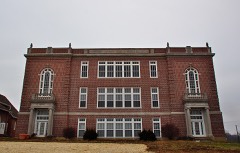 | Will Mayfield College Campus | 0.1 miles | 2013 |
| National Archives record | The nomination case file for reference 05000929 in Record Group 79. |
| Bollinger County | All 2 listed properties in this county. |