 Block
From the record
2 National Register listings published here.
Sources: the National Register database, National Park Service
79 topographic sheets cover 40 settlements here, and 2 properties are on the National Register of Historic Places.
2 National Register listings published here.
Sources: the National Register database, National Park Service
Every property in this county listed on the National Register of Historic Places, with the year it was listed and the federal nomination document.
| Photograph | Property | Type | Listed | Reference |
|---|---|---|---|---|
| Will Mayfield College Arts and Science Building | building | 2005 | 05000929 | |
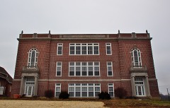 | Will Mayfield College Campus | building | 2013 | 12001176 |
Every wildfire the federal occurrence database records inside this county: 62 of them, burning about 356 acres. None started naturally and 4 were recorded as arson. Each settlement page carries the fires within five miles of it.
| Reported cause | Fires |
|---|---|
| Debris and open burning | 35 |
| Missing data/not specified/undetermined | 14 |
| Equipment and vehicle use | 6 |
| Arson/incendiarism | 4 |
| Smoking | 1 |
| Power generation/transmission/distribution | 1 |
| Recreation and ceremony | 1 |
The five largest, by the area the report gives. Two of them were set deliberately.
| Date | Cause | Size | Reported by | Name on the report |
|---|---|---|---|---|
| 4 March 2018 | Debris and open burning | 46 acres | Missouri Department of Conservation | 176610-00915-03042018-0630 |
| 18 July 1999 | Missing data/not specified/undetermined | 33 acres | Missouri Department of Conservation | not named |
| 10 March 2007 | Arson/incendiarism | 30 acres | Mark Twain National Forest | ARTESIAN WELL |
| 31 July 1999 | Debris and open burning | 20 acres | Missouri Department of Conservation | not named |
| 13 April 2001 | Arson/incendiarism | 15 acres | Missouri Department of Conservation | not named |
| 22 November 2018 | Debris and open burning | 12 acres | Missouri Department of Conservation | 177993-00902-11222018-1500 |
| 10 August 1999 | Missing data/not specified/undetermined | 10 acres | Missouri Department of Conservation | not named |
| 31 October 1996 | Missing data/not specified/undetermined | 10 acres | Missouri Department of Conservation | not named |
Every settlement page carries the fires within five miles of it - see the settlement index below.
The NOAA Storm Events Database holds 328 reports for this county, causing 12 deaths, 30 injuries and about $50,060,000 in recorded property damage. Each settlement page carries the reports that name it.
| Kind of event | Reports |
|---|---|
| Hail | 110 |
| Thunderstorm Wind | 105 |
| Flash Flood | 42 |
| Tornado | 30 |
| Flood | 23 |
| Heavy Rain | 11 |
| Funnel Cloud | 6 |
| Lightning | 1 |
The most serious of them, by death, then injury, then recorded damage. The accounts are quoted exactly as the forecast office filed them.
| When | Event | Place named | Harm | What the report says |
|---|---|---|---|---|
| April 2023 | Tornado (EF2) | Grassy | 5 killed, 4 hurt, $2,000,000 | The tornado moved northeast across central Bollinger County, passing just north and west of Marble Hill. The most severe damage occurred in Glenallen (near Marble Hill), where several fatalities and injuries occurred. All five occupants of a demolished mobile home were killed there, including two teenagers, a middle-aged adult, and two older adults. Several manufactured homes were totally destroyed. Approximately a couple of dozen homes suffered major structural damage, including roof damage, broken windows, and collapse of walls. Severe tree damage occurred in the vicinity of Glenallen, where hundreds of trees were snapped at the base. A dozen or so farm outbuildings sustained major damage along the path of the tornado. Peak winds were estimated near 130 mph at Glenallen. The maximum path width and damage rating were assigned to the Glenallen area along Highway 34. The tornado was very close to dissipating when it crossed into Cape Girardeau County. |
| November 2019 | Flash Flood | Sedgewickville | 3 killed, 2 hurt, $50,000 | Flash flooding of two creeks resulted in two separate fatal incidents involving vehicles swept off roads. In the first incident, a vehicle carrying four people was swept away at the low water crossing of the Little Whitewater Creek on County Road 356. This location is several miles south of Sedgwickville. Two of the occupants lost their lives, and the other two were treated for injuries. The survivors were the 33-year-old male driver and a 2-year-old boy. Two young boys aged 5 and 8 years old were killed. The location of the flash flood fatalities was in a hilly area, where numerous low water crossings are prone to frequent inundation. A volunteer firefighter familiar with the area estimated the water depth was 3 to 4 feet where the driver of the SUV attempted to cross the creek. The injured victims were airlifted or taken by ambulance to regional hospitals with moderate to serious injuries. The victims were all members of the same family. In the second incident, a truck was swept away at the low water crossing of Upper Whitewater Creek on County Road 234. This location is a couple miles east of Sedgwickville. The 48-year-old male driver from Louisiana was killed. The vehicle was found upside down in the water. |
| April 2002 | Tornado (F3) | Marble Hill | 1 killed, 16 hurt, $4,000,000 | This strong tornado with peak winds near 180 MPH touched down in a rural area southwest of Marble Hill. A total of 19 residences were severely damaged, and 6 were destroyed. Approximately 10 of the residences were mobile homes and 15 were single-family homes. Another 50 outbuildings, such as barns and sheds, were destroyed or damaged. Seven people were inside a house that was demolished. One of the victims, a 12-year-old boy, was thrown about 50 yards from the house and fatally injured. Several others in the immediate area, possibly the other occupants of the house, were thrown into a nearby lake and swam to safety. Of the 16 people injured in the tornado, four were air lifted to hospitals with serious injuries. Cars were stacked atop cars. Several residents were trapped inside the debris of their homes for up to 3 hours. The large number of trees down across roads delayed the arrival of rescue teams. |
| March 2008 | Flood | Patton | 1 killed, $4,800,000 | Historic flooding occurred after 12 to 14 inches of rain fell in 48 hours. One man was killed in Marble Hill when his pickup truck was swept off a highway into Crooked Creek. Most of the major highways in the county were closed for at least part of the day. Evacuations were conducted in some places, especially in Glenallen. About 23 people were rescued from a subdivision near Zalma due to flooding of the Castor River. Evacuation shelters were opened. Numerous water rescues were conducted around the county. Marble Hill was described as cut in half by severe flooding of Crooked Creek, which rose 8 to 10 feet above a major state highway into town. Much of Marble Hill was inundated. Schools were closed, businesses shut down, and campgrounds were evacuated. Many gravel roads were washed out, and many small bridges were destroyed. Initial estimates were that 75 percent of the county's roads were damaged. The emergency management director for the county reported 14 businesses and 15 homes in Marble Hill suffered severe damage. Fifteen homes in Glenallen and 30 homes in Zalma were severely damaged. A school and other public buildings were extensively damaged. A mobile home was washed away and smashed into trees. |
| May 2002 | Flash Flood | Countywide | 1 killed, $500,000 | no account filed |
| March 2023 | Flood | Hahn | 1 killed, $25,000 | One person drowned on the evening of the 25th after their car was driven into floodwaters that covered Missouri Highway H near County Road 706, just east of the Castor River Conservation Area. This was lingering flooding from a heavy rain event that occurred Thursday, March 23 through Friday, March 24. The victim was a 70-year-old woman from a neighboring county. She called for help at least twice after her car was in the water, but the car became submerged before first responders could arrive. |
| June 1977 | Tornado (F2) | not stated | 4 hurt, $250,000 | no account filed |
| October 1984 | Tornado (F1) | not stated | 3 hurt, $250,000 | no account filed |
| March 2019 | Tornado (EF2) | Grisham | 1 hurt, $60,000 | A National Weather Service damage survey revealed damage from an EF-2 tornado that started along County Road 844, only about a mile from the Madison County line. This tornado was spawned by the same supercell that produced a tornado inside Madison County. Due to the densely forested terrain, it could not be determined whether the Madison County track was connected to the Bollinger County track. The Bollinger County tornado formed along the headwaters of Crooked Creek in extreme western Bollinger County. The tornado then moved east across Highway 51. Several small sheds were moved or damaged along the path. Numerous trees were uprooted or snapped along the path as well. A man received minor scratches on his back when the tornado demolished his single-wide mobile home on County Road 344. The mobile home was tied down, but winds rolled the mobile home frame about 25 yards. The frame of the mobile home was twisted. The tornado attained its maximum EF-2 intensity rating at the site of the mobile home. Where the tornado crossed Highway 51, two small outbuildings were moved about 20 feet, and metal was peeled off the roof of a barn. The tornado ended along County Road 342 about eight miles north-northeast of Marble Hill. Peak winds were estimated near 120 mph where the mobile home was destroyed. |
| August 2023 | Flash Flood | Marble Hill | $20,000,000 | Significant flash flooding was reported from the Marble Hill area west-southwest along Highway 34 to the county line. Between 40 and 50 homes and businesses were damaged by flooding in the county. Highway 34 was shut down as a nearby creek flowed over it. At one point, 22 county highways and roads were flooded. Several county roadways were washed out, including bridges. Some of the washouts were 8 to 10 feet deep. Flooding occurred at the main bridge in Marble Hill. Sixteen individuals were rescued from floodwaters throughout the county. Up to 6 feet of water was flowing in some locations. Water flowing 3 to 4 feet deep was observed in Marble Hill. Water was in buildings in Glenallen. Close to the Wayne County line, water was into numerous campers at Twin Bridges Park. Significant flooding occurred near the intersection of Highway Y and Highway 34. Water rescues occurred at the Castor River Campground west of Grassy. The two-day rainfall total at the Marble Hill co-op observation site was 5.73 inches, which occurred on the 13th and 14th. Total flood damage to public infrastructure in the county was conservatively estimated at 18.2 million dollars. Some of this total may have occurred in other flash flood events earlier in the month. |
| May 2009 | Thunderstorm Wind | North Patton | $8,000,000 | Thousands of trees were blown down, primarily across northern parts of the county. A lot of structural damage occurred along Highway 72. About 250 homes received some degree of damage, ranging from loose shingles to roofs lifted off. Many barns and outbuildings were destroyed. The Patton and Sedgewickville areas were the hardest hit. In particular, the area from Sedgewickville west to the Madison County line suffered extreme damage. Trees fell on houses, roads, and power lines. Power poles were snapped. Extended power outages lasting 3 to 5 days were widespread. A 28-foot camper was overturned in Sedgewickville. Nearby, a manufacturing company was heavily damaged. Six cars parked in front of the building were crushed by metal beams. The roof of the building was torn off. Across the damage area, emergency workers conducted door-to-door welfare checks. Food and water were distributed to those without power. Blocked roads were a major setback to recovery efforts. The damage was almost all north of Marble Hill. |
| March 2025 | Tornado (EF3) | Sitzke Store | $3,000,000 | An EF-3 tornado touched down northeast of Greenville in Wayne County and proceeded northeast to the Bollinger County line southeast of Gravelton. It continued northeast to near the southeast corner of Madison County and eventually dissipated just west of Hurricane. The tornado snapped or uprooted thousands of trees along its path. Two houses sustained major damage and over a dozen homes had at least some minor damage. One barn lost its roof and one wooden power pole was destroyed. The estimated peak wind speed was 140 mph. The total path length was 28.6 miles. |
| May 2000 | Hail | Marble Hill | $1,000,000 | Spotters reported golf ball size hail in Marble Hill, and baseball size hail in Leopold. Two car dealerships in Marble Hill reported their entire inventory of vehicles received damage. One insurance agent in Marble Hill received hail-damage claims on 10 homes and 60 vehicles. Of those 60 vehicles, 20 were declared total losses. Damage to homes consisted almost entirely of roof damage. Newspaper photos showed baseball size hail covering the ground on Highway 51, 2 miles south of the Marble Hill city limit. |
| November 2005 | Flash Flood | Countywide | $750,000 | Several water rescues were conducted after 6 to 9 inches of rain fell, causing major flooding of the Castor River. The river flooded across Highway 34 near the Wayne County line, leaving several people trapped. Boats from the sheriff department, the State Water Patrol, and the Department of Conservation were involved in the rescues. Four people were stranded when their vehicle was swept off a flooded county road south of the Twin Bridges Campground. The four people were picked up by a passing boat, but the boat motor was not strong enough for the current. The four people were finally rescued by a state trooper in another boat. The Twin Bridges Campground was completely flooded. One of the permanent trailers in the campground was surrounded by water. The trailer occupants were rescued from the roof of the trailer by boat. At the Castor River campground, several RV's and campers were heavily damaged by the river flooding. Water came up to the bridge on Highway 51 at Zalma. A bridge was washed out on County Road 350 and another was badly damaged on County Road 348. In Marble Hill, floodwaters from Crooked Creek invaded several homes and a few businesses. On the Lutesville side of the creek, a few cars were flooded, and a few people were trapped in their apartments. A co-operative observer in Marble Hill measured 7.92 inches from the overnight and early morning round of storms. The automated gage at Patterson reported 7.23 inches. There was an unofficial report of 10 inches from a resident along Crooked Creek. The resident reported that a cabin on five-foot stilts was flooded with a foot of water, and that entire trees were swept down the creek. |
| April 2017 | Flash Flood | Dongola | $500,000 | Significant flash flooding of creeks and roads occurred around the county. In Marble Hill, Crooked Creek rose far outside its banks into portions of the city. Floodwaters crept into nearby homes and crossed the main road through town. A few inches of water were observed in a business. Highway 51 was closed due to Crooked Creek flooding. Buildings on both sides of Highway 51 were flooded. About six homes were damaged, and two were destroyed. One business received major damage. Elsewhere in the county, flooding of roads occurred, mainly in the southern part of the county. Highway H was flooded just before Highway 51, along with an area near the junction of Highways 51 and 91. |
| June 1994 | Thunderstorm Wind | Marble Hill | $500,000 | Numerous large trees and power lines were blown down in Grassy. A swath of damaging wind and hail nearly 15 miles wide destroyed a new 100 x 30 foot pole barn and knocked down numerous trees between Marble Hill and Advance. A lumber shed on Highway 34 was completely destroyed as well. |
| October 2021 | Tornado (EF1) | Gipsy | $400,000 | The tornado crossed into Bollinger County from Wayne County. The tornado directly affected the community of Zalma, where the school gymnasium roof was damaged. Air conditioning units were blown off the school roof. The top half of a two-story barn was destroyed. There was roof damage to a chicken house. Otherwise, the majority of the path was through densely wooded farm country, where numerous trees were uprooted or snapped. Peak winds were estimated near 105 mph. |
| April 2006 | Hail | Arab | $350,000 | Baseball size hail was reported in Zalma. Golf ball hail was reported elsewhere in southwest Bollinger County. Dozens of residents in southern portions of the county reported damage. A resident near Zalma reported extensive hail damage to his home, mainly to the west end of the house and garage. Holes were punched in the vinyl siding, and a skylight was busted. Several other houses in the vicinity were damaged. At least one vehicle was extensively damaged by hail. |
| May 2011 | Flood | Alliance | $350,000 | no account filed |
| October 2014 | Tornado (EF1) | Zalma | $250,000 | The tornado destroyed two small barns and a few small silos. The silos were blown toward the west across a road. A mobile home was shifted off its foundation. At a residence next to the mobile home, the roof of the front porch was blown over the house. A carport collapsed on vehicles. Minor damage occurred to a home, mainly to windows. Numerous trees were snapped and uprooted along the path. One tree landed on a house. A 40-by-60 foot shed was destroyed. Peak winds were estimated near 105 mph. |
| April 2011 | Tornado (EF1) | Sedgewickville | $200,000 | The south half of a roof was torn completely off, including the roof decking. A power pole was snapped. Debris was hanging in trees along the damage path. Dozens of trees were snapped or uprooted. At the end of the path, a mobile home was blown into a shed. Rescue crews had difficulty reaching a woman trapped inside the mobile home because of flooded roads. Both the shed and mobile home were demolished. Peak winds were estimated near 100 mph. The average path width was 50 yards. |
| April 2011 | Thunderstorm Wind | Sitzke Store | $150,000 | Winds were estimated from 70 to 75 mph in a wide area, mainly north and west of Marble Hill. Widespread damage to trees and power lines occurred. The roofs were damaged on some homes. A tree went through the roof of a house on Highway Y off Route 34. Many sheds were damaged. |
| January 1999 | Thunderstorm Wind | Arab | $150,000 | Thunderstorm winds estimated near 95 MPH overturned a vehicle. A house along Highway 51 was heavily damaged and pushed off its foundation. In the same area, a small shed and a large truck shed were destroyed. Along Highway C, a church lost part of its roof, and a small front porch was torn off and deposited behind the building. |
| March 2025 | Tornado (EF1) | North Patton | $100,000 | An EF-1 tornado touched down near County Road 906 southwest of Precinct and moved northeast to the Perry County line near Highway KK. The tornado destroyed a carport and shed on the same property along Highway 51 and took the roof off a barn also along Highway 51. Otherwise, the tornado damaged trees all along its path through Bollinger County. The estimated peak wind was 90 mph. The tornado went on to produce EF-2 damage in Perry County and then crossed the Mississippi River into Randolph County Illinois. The total path length was 33.5 miles. |
| July 2012 | Thunderstorm Wind | Marble Hill | $100,000 | Numerous trees were blown down, causing power outages. A two-foot diameter tree fell on a residence. A large storage building was damaged. The roof of a downtown auto parts store was damaged. |
| February 2012 | Tornado (EF1) | Grisham | $100,000 | Six to eight homes sustained roof damage along Highway 72. The roof damage consisted mainly of shingle damage. Ten larger barns received roof damage over a five-mile area. Numerous trees were uprooted and snapped. Numerous power poles were down. The average path width was 800 yards. Peak winds were estimated near 90 mph. |
| May 2007 | Thunderstorm Wind | Marble Hill | $100,000 | In Marble Hill, large trees and numerous power poles were blown down. An 80-year-old oak tree damaged an upper deck on a house and crushed two storage buildings. Tree limbs fell on electrical lines near the city pump house. A 12-inch tree limb blocked a road. North of Marble Hill, near the intersection of Highway 51 North and Highway M, a building under construction was flattened. |
| May 1997 | Flash Flood | Marble Hill | $100,000 | Thunderstorms produced rainfall amounts from 2 to 5 inches in northern Bollinger County within several hours time. Dozens of roads across the county were closed by flooding. Parts of Marble Hill and Lutesville were evacuated due to severe flooding of Crooked Creek. Cane Creek and the Castor River also flooded. A local official stated this was the worst flash flooding since 1983 in Bollinger County. |
| May 2000 | Tornado (F1) | Sturdivant | $75,000 | The tornado caused moderate to heavy damage to one residence, and minor damage to a second residence. Tree limbs were speared into walls of the heavily damaged home. Three storage buildings and a horse barn were destroyed. A number of trees were uprooted. |
| May 1995 | Thunderstorm Wind | Arab | $75,000 | A house was destroyed by thunderstorm winds in excess of 100 MPH. Only a few interior walls were left standing. |
| May 2024 | Tornado (EF1) | Grisham | $70,000 | An EF-1 tornado began in Marquand in Madison County, then traveled southeast into Bollinger County near County Rd 846, causing uprooted trees and large broken branches. It crossed County Rd 844, and then went on to cause a swath of substantial tree damage (snapped and uprooted trees) near Crooked Creek. The tornado then moved in a more easterly direction south of the Hawn Creek Access area, before crossing County Rd 848. A home had part of its porch lifted up and damaged in this location along with large tree limbs broken. The tornado then caused a fairly decent swath of tree damage in some forested areas north of County Rd 846/Hwy 00. At the end of the tornado track, the roof of a barn was destroyed and the debris was tossed onto the adjacent home, causing roof damage. Estimated peak winds for the Bollinger County portion of this tornado, and the tornado as a whole, were 100 mph. |
| October 2013 | Tornado (EF1) | Leopold | $70,000 | This tornado contained peak winds near 95 mph. Dozens of trees were snapped and uprooted. A pavilion was damaged by a falling tree. Some shingles were blown off a few homes. |
| February 2012 | Tornado (EF2) | Mayfield | $70,000 | Several large trees were snapped or uprooted. The walls of a machine shed were blown out and a large barn was collapsed. The tornado path continued into Cape Girardeau County. |
| March 2009 | Tornado (EF1) | Leopold | $60,000 | Several houses received major shingle damage. A barn was destroyed. Two-by-fours were driven through the exterior wall of a well-built home. A garage wall was blown out. A few other barns sustained significant structural damage. The damage path was not continuous. Peak winds were estimated near 85 mph. The tornado continued into Cape Girardeau County. |
| June 2019 | Thunderstorm Wind | Patton | $50,000 | Widespread damaging winds crossed much of the county. Numerous trees and power lines were down in parts of Bollinger County. At least one vehicle was damaged by a falling tree. Power lines were down at Patton. Four miles south-southwest of Patton, trees were snapped, and there was damage to the porch on a house. |
| December 2013 | Flash Flood | Gipsy | $50,000 | A water rescue was conducted by the fire department on Highway P and TT near the border of Wayne County. Flash flooding of Crooked Creek surrounded a restaurant in Marble Hill. Parts of Highways H, P, and W were closed. |
| April 2013 | Thunderstorm Wind | Zalma | $50,000 | Trees were uprooted, and tree limbs were broken. Homes lost shingles. Barns and sheds were damaged. A large tree was uprooted on Highway 51 about a mile north of Zalma. |
| April 2006 | Hail | Zalma | $50,000 | A resident in the southeast part of the county reported hail dented the metal roof on his home. Dozens of residents in southern portions of the county reported hail damage. On Highway 51 near Highway W, the hail was deep enough to plow. |
| October 2004 | Hail | Patton Jct | $50,000 | Hail up to the size of tennis balls was reported 4 miles north of Sedgewickville with this supercell thunderstorm. Quarter to golf ball size hail was reported in Sedgewickville and Patton Junction. |
| April 2002 | Hail | Glenallen | $50,000 | Very large hail fell in the Marble Hill area. Tennis ball size hail was reported a few miles south of Marble Hill, and ping pong ball to golf ball size hail fell at Glenallen and near Lutesville. Windows were knocked out of a few homes and vehicles. The hail caused damage to siding and outdoor furniture, as well. |
| February 1999 | Thunderstorm Wind | Marble Hill | $50,000 | Thunderstorm winds blew a house trailer off its foundation and partially unroofed a machine shed. A large old building was destroyed. |
| April 1994 | Thunderstorm Wind | Patton Junction | $50,000 | A local newspaper reported wind damage to a home along Highway 51. The second floor and roof were ripped off the house and spread debris some 100 yards away. No injuries were reported. |
| June 1994 | Thunderstorm Wind | Dongola | $50,000 | Numerous large trees and power lines were blown down in Grassy. A swath of damaging wind and hail nearly 15 miles wide destroyed a new 100 x 30 foot pole barn and knocked down numerous trees between Marble Hill and Advance. A lumber shed on Highway 34 was completely destroyed as well. |
| April 1994 | Hail | Grassy | $50,000 | Windshields were broken out of several cars. |
| April 1994 | Hail | Zalma | $50,000 | Windshields were broken out of several cars. |
| November 1993 | Tornado (F0) | Zelma | $50,000 | A small tornado touched down briefly knocking power lines and a few trees down. A few barns, homes, and an area school also suffered light damage. |
| June 2000 | Flash Flood | Grassy | $50,000 | no account filed |
| April 2024 | Thunderstorm Wind | Lodge | $40,000 | Downburst winds downed a few trees near the intersection of DD and County Rd 822. Additionally, a shed had its roof blown off and another small shed was blown over. Two tractor trailer cab shells were blown over as well. |
| May 2024 | Thunderstorm Wind | Beesville | $40,000 | Trees were downed by thunderstorm winds onto two separate homes near the intersection of County Rd 840 and Hwy 00. |
| May 2011 | Thunderstorm Wind | Lutesville | $40,000 | Wind speeds were estimated from 70 to 80 mph over much of the county. Trees were blown down on several roadways. One tree fell on a home along Highway 72. |
| May 2003 | Tornado (F2) | Grassy | $40,000 | A mobile home, a house, and a barn was destroyed. Most of the damage was on County Road 702. Peak winds were estimated around 130 MPH. |
| May 1999 | Thunderstorm Wind | Countywide | $40,000 | Numerous trees and power lines were down. Trees were blown down across a highway. A shop building blew down with a man inside, but he was not injured. The county emergency management director estimated wind speeds up to 80 MPH. |
| March 2023 | Flash Flood | Marble Hill | $30,000 | Floodwaters from Crooked Creek covered U.S. Highway 51 and entered a store on the north side of town. |
| January 2020 | Tornado (EF1) | Patton Jct | $30,000 | The tornado briefly touched down along Highway 72. The workshop portion of a home-workshop combination building was destroyed. The roof was torn off a nearby barn. Debris was thrown to the east about 100 yards, to the south about 100 feet, and to the west less than 20 feet. A few trees were uprooted. Peak winds were estimated near 105 mph. |
| May 2015 | Thunderstorm Wind | Zalma | $30,000 | Extensive damage occurred within the town limits of Zalma. About two dozen trees were uprooted or snapped. At least one tree landed on a house, and another tree hit a vehicle. |
| May 2011 | Tornado (EF1) | Grisham | $30,000 | The tornado continued into Bollinger County from Madison County. Hundreds of trees were uprooted and snapped. Peak winds were estimated near 100 mph. The average path width was 200 yards. |
| October 2007 | Thunderstorm Wind | Marble Hill | $30,000 | A wind gust to 70 mph was measured 4 miles south of Marble Hill, where trees were blown down. Five downed trees and some power lines blocked streets in the city of Marble Hill. Business signs were overturned. Power lines were down in the Leopold area. Numerous power outages were reported. |
| May 2023 | Hail | Leopold | $25,000 | The hail was reported to be at least the size of quarters. |
| April 1999 | Thunderstorm Wind | Glenallen | $25,000 | Several trees were blown down, and barn roofs were blown away. |
| April 1968 | Tornado (F2) | not stated | $25,000 | no account filed |
The Survey's mineral resources record lists 94 workings inside this county. 2 still produce and 92 are closed or unrecorded. Each settlement page carries the workings within five miles of it.
| Commodity | Workings |
|---|---|
| Clay | 42 |
| Iron | 39 |
| Stone, Crushed/Broken | 10 |
| Sand and Gravel, Construction | 7 |
| Coal | 2 |
| Lead | 1 |
| Zinc, Copper | 1 |
| Nickel, Cobalt | 1 |
The least common of them first, because a county's hundredth gravel pit says nothing its first ten did not.
| Where | Site | Commodity | Status | Recorded |
|---|---|---|---|---|
| Higdon Mine | Lead, Zinc, Copper, Nickel, Cobalt | Prospect | 1963 | |
| Baker Mine | Iron, Coal | Past Producer | ||
| Tibbs Bank | Iron, Coal | Past Producer | ||
| Bollinger County Highway Dept. Sg | Sand and Gravel, Construction | Producer | ||
| Trentham S&G Plant | Sand and Gravel, Construction | Producer | ||
| Unknown | Sand and Gravel, Construction | Past Producer | ||
| Unknown | Sand and Gravel, Construction | Past Producer | ||
| Unknown | Sand and Gravel, Construction | Past Producer | ||
| Unknown | Sand and Gravel, Construction | Past Producer | ||
| Unknown | Sand and Gravel, Construction | Past Producer | ||
| Hahn Quarry | Stone, Crushed/Broken | Past Producer | ||
| Sharp Pit | Clay, Stone, Crushed/Broken | Past Producer | ||
| Turley & Briggs Quarry | Stone, Crushed/Broken | Past Producer | ||
| Unknown | Stone, Crushed/Broken | Past Producer | ||
| Unknown | Stone, Crushed/Broken | Past Producer | ||
| Unknown | Stone, Crushed/Broken | Past Producer | ||
| Unknown | Stone, Crushed/Broken | Past Producer | ||
| Unknown | Stone, Crushed/Broken | Past Producer | ||
| Unknown | Stone, Crushed/Broken | Past Producer | ||
| Unknown | Clay, Stone, Crushed/Broken | Past Producer | ||
| Bollinger Land | Iron | Past Producer | ||
| Caldwell Bank | Iron | Past Producer | ||
| Cozean Mine | Iron | Past Producer | ||
| Critts Land | Iron | Prospect | ||
| Fox Bank | Iron | Past Producer | ||
| Gale Slinkard Mine | Iron | Past Producer | ||
| Gilmore Mine | Iron | Past Producer | ||
| Glenn Emma Mine | Iron | Past Producer | 1873, 1875 | |
| Glenn Emma Mine | Iron | Past Producer | ||
| Hahn Mine | Clay, Iron | Past Producer | ||
| Howell Land | Iron | Past Producer | ||
| Jesse Lutes Bank | Clay, Iron | Past Producer | ||
| Lemon Land | Iron | Past Producer | ||
| Lornug Bank | Clay, Iron | Past Producer | ||
| Lutes Diggings | Iron | Past Producer | ||
| Lux Bank | Iron | Past Producer | ||
| Mcgregor Bank | Iron | Past Producer | ||
| Murdock Bank | Iron | Past Producer | ||
| Myers Bank | Iron | Past Producer | Marcasite | |
| Myers Bank | Iron | Past Producer | ||
| Nifong Bank | Iron | Occurrence | Limonite | |
| Nifong Bank | Iron | Past Producer | ||
| Pavlick Bank | Iron | Past Producer | ||
| Reed Bank | Iron | Occurrence | ||
| Revelle Bank | Iron | Past Producer | ||
| Rhodes Bank | Iron | Past Producer | ||
| Rhodes Prospect | Iron | Past Producer | ||
| Richards Mine | Iron | Past Producer | ||
| Robbins Bank | Iron | Past Producer | ||
| Rogers Bank | Iron | Past Producer | ||
| Shell Bank | Iron | Past Producer | ||
| Shrum Mine | Iron | Past Producer | ||
| Turkey Hill Bank | Iron | Past Producer | ||
| Unknown | Iron | Past Producer | ||
| Unknown | Iron | Past Producer | ||
| Unknown | Iron | Past Producer | ||
| Unknown | Iron | Past Producer | ||
| Bauscher Mine | Clay | Past Producer | ||
| Chas Flueher Clay Pit | Clay | Past Producer | ||
| Crawford Pit | Clay | Past Producer | ||
| Cushman Pit | Clay | Past Producer | ||
| Dobshutz Pit | Clay | Past Producer | ||
| Einwechter Pit | Clay | Past Producer | ||
| Elledge Clay Pit | Clay | Prospect | ||
| Jones Pit | Clay | Past Producer | ||
| Kinder Pit | Clay | Past Producer | ||
| Low Pit | Clay | Past Producer | ||
| Lutz Pit | Clay | Past Producer | ||
| Lyley Pit | Clay | Past Producer | ||
| Mcclinich Pit | Clay | Past Producer | ||
| Mcmanus Pit | Clay | Past Producer | ||
| Menninger Pit | Clay | Past Producer | ||
| Morgan Pit | Clay | Past Producer | ||
| Nenninger Mine | Clay | Past Producer | ||
| Pat Huskey Mine | Clay | Past Producer | ||
| Reilly Pit | Clay | Past Producer | ||
| Slemmer Pit | Clay | Past Producer | ||
| Smith Pit | Clay | Past Producer | ||
| Snyder Pit | Clay | Past Producer | ||
| Sommers Pit | Clay | Past Producer | ||
| Stam Mine | Clay | Past Producer | ||
| Stemm Mine | Clay | Past Producer | ||
| Stenum Pit | Clay | Past Producer | ||
| Stevens Pit | Clay | Past Producer | ||
| Unknown | Clay | Past Producer | ||
| Unknown | Clay | Past Producer | ||
| Unknown | Clay | Past Producer | ||
| Unknown | Clay | Past Producer | ||
| Unknown | Clay | Past Producer | ||
| Unknown | Clay | Past Producer | ||
| Unknown | Clay | Past Producer | ||
| Unknown | Clay | Past Producer | ||
| Waldo Pit | Clay | Past Producer | ||
| Weasmer Pit | Clay | Past Producer |
Named settlements recorded in the Geographic Names Information System, each with the topographic sheets covering it. Villages, hamlets and abandoned places alike. Each is shown with the nearest named watercourse or landform and the survey quadrangle it falls on.
Union township · 63781 · On Shrum Creek · Sedgewickville quadrangle
17 sheets, 1923 to 1987
Crooked Creek township · 63764 · On Turkey Creek · Glenallen quadrangle
18 sheets, 1933 to 1989
Whitewater township · 63781 · On Bollinger Creek · Sedgewickville quadrangle
17 sheets, 1923 to 1987
Lorance township · 63760 · On Granny Creek · Burfordville quadrangle
18 sheets, 1933 to 1987
Crooked Creek township · 63751 · On Turkey Creek · Hurricane quadrangle
19 sheets, 1933 to 2000
Crooked Creek township · 63764 · On Alex Branch · Hurricane quadrangle
19 sheets, 1933 to 2000
Lorance township · 63764 · On Dockins Branch · Marble Hill quadrangle
19 sheets, 1933 to 1987
Crooked Creek township · 63655 · On Summers Creek · Hurricane quadrangle
19 sheets, 1933 to 2000
Lorance township · 63764 · On Hurricane Creek · Marble Hill quadrangle
19 sheets, 1933 to 1987
Lorance township · 63764 · On Hurricane Creek · Marble Hill quadrangle
19 sheets, 1933 to 1987
Union township · 63662 · On Baltimore Creek · Patton quadrangle
19 sheets, 1910 to 2000
Union township · 63662 · On Baltimore Creek · Patton quadrangle
19 sheets, 1910 to 2000
Crooked Creek township · 63764 · On Shrum Branch · Hurricane quadrangle
19 sheets, 1933 to 2000
Crooked Creek township · 63764 · On Henson Branch · Hurricane quadrangle
19 sheets, 1933 to 2000
The vanished settlements of Bollinger County: the places named above that are no longer on the map.