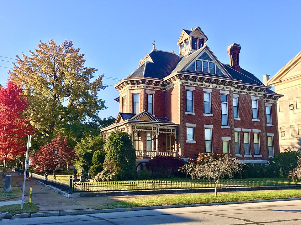
Built in 1891 (Victorian architecture). Listed on the National Register of Historic Places in 2020.
From the record
“The Elijah Thomas Webb Residence is a historic home in Webb City, Missouri. It was added to the National Register of Historic Places in 2020 as an "outstanding example of a high-style Queen Anne residence." The three-story building was built c. 1891 and has retained many of its original details.”
Wikipedia article Elijah Thomas Webb Residence, CC BY-SA 4.0.
One of 43 National Register listings published here for Jasper County · listed in 2020 · category: Building · built in 1891, Victorian architecture.
Galena, Empire City, Thurman, Webb City, Carterville, Oronogo, Smithfield, Carl Junction, and Blende City, are, strictly speaking, little more than suburban towns, each paying royalty to the great city around which they cluster, and upon which they are in great part dependent.
Telephone Exchange. - In the fall of 1881 Mr. C. W. McDaniel, of the Joplin Telephone Company, constructed, by right of franchise purchased, lines connecting Joplin with Carthage, Oronogo, Webb City, Carterville, Galena, and Empire Cit}-, Kansas. In October of that year these lines were put in operation. In an almost incredibly short time a sufficient number of persons agreed to take instruments to warrant the company in erecting wires and poles throughout the entire city. The fact that there are upwards of two hundred instruments in use on this line, certainly speaks well for the popularity and influence of the telephone, and particularly tiie liberality and enterprise of Joplin citizens. A telephone wire runs from the central oflice to the White Lead- works; another to the Zinc-works; one to the Granby Mining and Smelting Company's Works; also, one to the Southwest Lead and Zinc Company's Works. All the railroad offices, banks, hotels, the prin- cipal business houses and residences have their telephones. The lines from the first have been under the able supervision and management of Mr. Charles W, McDaniel.
Regional context, not property-specific
evidence. The
federal wildfire occurrence database
lists 21 fires within 5 miles of Elijah Thomas Webb House
between 1993 and 2020, burning about 116 acres in total. None started naturally. None was recorded as arson.
Distance is straight-line from the map coordinates, so a fire counted
here may appear on a neighbouring settlement's page as well.
Reported cause
Fires
Debris and open burning
11
Missing data/not specified/undetermined
10
The most recent of
them, most recent first, with the day each was reported and the service
that recorded it.
Regional context, not property-specific
evidence. The federal mineral resources record lists
815 workings within 5 miles of Elijah Thomas Webb House: 807 past producers, 6 producers, 1 unknown, 1 occurrence.
6 still produce. What was taken out: Zinc, Lead, Lead, Zinc, Stone, Crushed/Broken, Zinc. Distance is straight-line from the
map coordinates, so a quarry counted here may appear on a neighbouring
settlement's page as well.
Regional context, not property-specific
evidence. The National Weather Service names
Webb City, the town this property stands in, in 47 storm reports between 1994 and 2026: 23 thunderstorm wind, 18 hail, 4 flash flood, 1 funnel cloud.
No death or injury is recorded in these reports. Each account below is quoted exactly as the forecast office
filed it, from the NOAA Storm Events Database, and each date
opens the federal record of that event.
A NWS storm survey found straight line wind damage across portions of Webb City. Damage was focused in a path to the east northeast bending the steel Walmart sign and moving cart corrals. Damage included pulling the eve of a roof back on a nearby strip mall and blowing two HVAC units off a roof. A few small to medium sized trees were blown over. Numerous limbs were then downed from Webb City to Carthage. Wind speed was estimated at 70 to 80 mph.
Heavy thunderstorms produced torrential rainfall across Jasper County which lead to flooding. Several roads were closed to motorists by high water in and near Carthage. The intersection of County Road 170 and Jack Pine Road near the Spring River was closed and impassable to motorists. The intersection of Locust and Civil War roads was also closed to traffic due to high water. In Webb City, Mo., the intersection of Main Street and Broadway was closed to motorists with several inches of water covering the roads. In Carl Junction, Mo., roads and walkways in the Carl Junction Park were closed to traffic for several hours.
No historic map-sheet match is published
for this property yet. That does not mean no map exists. This record needs
a coordinate-quality review before it can be joined to a sheet boundary.
Browse the county's mapped places while that work is
pending.
Listed places nearby
6 within 8 miles
Other National Register properties close
enough to walk or drive between, ordered by distance from this one. Both
positions come from the same geocoding pass that matched these properties
to their map sheets.
Listing record. National Park Service National Register of Historic Places, listed-properties dataset, current to 2026-05-22.
Map join. Address geocoded through the United States Census geocoder, then tested against the published boundary of every sheet in the USGS Historical Topographic Map Collection.
How this page is made. Listing fields come from federal records; map-sheet coverage is a labelled coordinate-to-boundary calculation, not a source-field claim.
Wildfire. Short, Karen C. 2022. Spatial wildfire occurrence data for the United States, 1992-2020 [FPA_FOD_20221014]. 6th Edition. Fort Collins, CO: Forest Service Research Data Archive. https://doi.org/10.2737/RDS-2013-0009.6 Collected with United States Government funding and usable without additional permissions or fees.
Mines and quarries. USGS Mineral Resources Data System (MRDS) https://mrdata.usgs.gov/mrds/ A work of the United States government, no copyright under 17 U.S.C. 105.
Storms. NOAA National Centers for Environmental Information, Storm Events Database https://www.ncei.noaa.gov/stormevents/ A work of the United States government, no copyright under 17 U.S.C. 105. Narratives are quoted verbatim from the National Weather Service report and are not edited or summarised.
 Block