 Block
From the record
One of 63 National Register listings published here for Buchanan County · listed in 2014 · category: Building.
Sources: the National Register database, National Park Service · the Wikipedia article
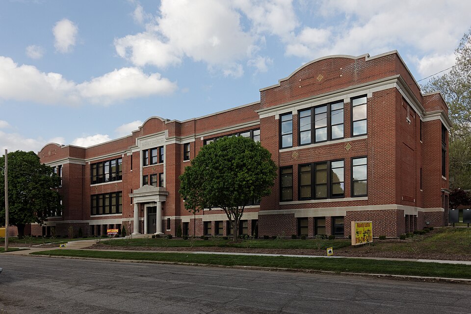
Listed on the National Register of Historic Places in 2014.
One of 63 National Register listings published here for Buchanan County · listed in 2014 · category: Building.
Sources: the National Register database, National Park Service · the Wikipedia article
The chapter on Washington Township in History of Buchanan County and the City of St. Joseph and Representative Citizens : 1826 to 1904, published 1904 names St. Joseph. This is what it says, exactly as the scans read.
Some of the early farms in Washington township now form a part of the city of St. Joseph. The following persons are mentioned in history as having settled prior to 1840: John H. Whitehead, William Whitehead, Henr}- \\\ Hanson, James Cochran, Frederick Waymire, William Pugh, Clayborne F. Palmer, A. C. Hyde, Thomas, John and Elisha Sollars. Stephen Parker, Isaac and Michael ^liller, James G. Karnes, Alexander Fudge, Leroy Kauffman, Benjamin Williams, Jacoli (iroschon. Logan Jones, Edward Maxwell, _F)hn H. Cox, Da\id Ewing, William Sallee, Joseph Davis, George Coughern, Michael Rogers, F.
Passage source: History of Buchanan County and the City of St. Joseph and Representative Citizens : 1826 to 1904, published 1904.
Washington township has three justices of the peace and one constable, who are stationed at St. Joseph. There are four post offices in the township, besides St. Joseph - Stock Yards (South St. Joseph), Vories (South Park), Inza (Hyde's Addition) and Saxton.
Passage source: History of Buchanan County and the City of St. Joseph and Representative Citizens : 1826 to 1904, published 1904.
Machine-read from a century-old scan, so expect the errors a machine makes: misspelled names, dropped words, stray characters.
Read the whole chapter on Washington Township - 190 words on its settlement, mills, schools and churches.
Regional context, not property-specific evidence. The federal wildfire occurrence database lists 8 fires within 5 miles of Neely Elementary School between 1995 and 2018, burning about 806 acres in total. None started naturally. 1 was recorded as arson. Distance is straight-line from the map coordinates, so a fire counted here may appear on a neighbouring settlement's page as well.
| Reported cause | Fires |
|---|---|
| Missing data/not specified/undetermined | 5 |
| Debris and open burning | 1 |
| Equipment and vehicle use | 1 |
| Arson/incendiarism | 1 |
The most recent of them, most recent first, with the day each was reported and the service that recorded it.
| Date | Cause | Size | Reported by | Name on the report |
|---|---|---|---|---|
| 14 September 2017 | Equipment and vehicle use | 1.0 acres | Doniphan County | 017-108 |
| 10 April 2018 | Missing data/not specified/undetermined | 2.5 acres | Missouri Department of Conservation | 177644-01110-04102018-1806 |
| 26 March 1995 | Arson/incendiarism | 1.0 acres | Missouri Department of Conservation | not named |
| 15 March 2015 | Missing data/not specified/undetermined | 400 acres | Kansas Forest Service | 28 |
| 14 March 2015 | Missing data/not specified/undetermined | 400 acres | Kansas Forest Service | 27 |
| 31 December 2001 | Missing data/not specified/undetermined | 1.0 acres | Missouri Department of Conservation | not named |
| 7 January 2018 | Missing data/not specified/undetermined | under an acre | Missouri Department of Conservation | 165953-01180-01072018-1213 |
| 14 January 2016 | Debris and open burning | under an acre | Kansas Forest Service | 5 |
Regional context, not property-specific evidence. The federal mineral resources record lists 24 workings within 5 miles of Neely Elementary School: 23 past producers, 1 producer. 1 still produces. What was taken out: Stone, Crushed/Broken, Sand and Gravel, Construction. Distance is straight-line from the map coordinates, so a quarry counted here may appear on a neighbouring settlement's page as well.
| Where | Site | Commodity | Status | Recorded |
|---|---|---|---|---|
| St Joseph Dredge | Sand and Gravel, Construction | Producer | ||
| Unknown | Sand and Gravel, Construction | Past Producer | ||
| Unknown | Sand and Gravel, Construction | Past Producer | ||
| Unknown | Sand and Gravel, Construction | Past Producer | ||
| Unknown | Sand and Gravel, Construction | Past Producer | ||
| City Quarry | Stone, Crushed/Broken | Past Producer | ||
| Farmer & Dunn Quarry | Stone, Crushed/Broken | Past Producer | ||
| Heuemander Quarry | Stone, Crushed/Broken | Past Producer | ||
| Heumander Quarry | Stone, Crushed/Broken | Past Producer | ||
| Roth Quarry | Stone, Crushed/Broken | Past Producer |
No historic map-sheet match is published for this property yet. That does not mean no map exists. This record needs a coordinate-quality review before it can be joined to a sheet boundary. Browse the county's mapped places while that work is pending.
Other National Register properties close enough to walk or drive between, ordered by distance from this one. Both positions come from the same geocoding pass that matched these properties to their map sheets.
| Photograph | Property | Distance | Listed |
|---|---|---|---|
| Jesse James House | 0.4 miles | 1980 | |
| John Patee House | 0.5 miles | 1966 | |
 | Western Tablet and Stationery Company, Building #2 | 0.5 miles | 2007 |
 | Robidoux School | 0.5 miles | 1983 |
| Pony Express Stables | 0.5 miles | 1970 | |
| Patee Town Historic District | 0.7 miles | 2002 |
| National Archives record | The nomination case file for reference 14000328 in Record Group 79. |
| Wikipedia article | Community-written account of this property, licensed CC BY-SA. |
| Buchanan County | All 63 listed properties in this county. |