
BlockBefore
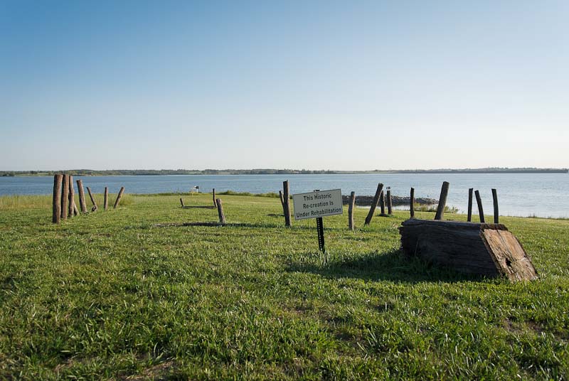
Photograph of Aker Cemetery
Photograph by Bob Simrak, CC BY-SA 3.0. Via Wikimedia Commons.

Aker Cemetery

Listed on the National Register of Historic Places in 1974.

From the record

“Aker Cemetery is a historic cemetery located near Smithville, Missouri. The Aker Cemetery is the only remaining evidence of the initial settlers in the area.”

Wikipedia article Aker Cemetery, CC BY-SA 4.0.

One of 39 National Register listings published here for Clay County · listed in 1974 · category: Site.

Sources: the Wikipedia article · the case file at the National Archives · the National Register database, National Park Service

The listing

  • What is counted as historic. The nomination lists 1 site as contributing to the listing.
  • Address. NE of Smithville off MO W, Smithville, 64089
  • When was it listed? November 1974
  • Category. site
  • Township. Platte township
  • National Register reference number. 74001071 - the number the National Park Service assigned this property when it was listed, and the key its nomination file is catalogued under at the National Archives.

Fires near this property

16 since 2006

Regional context, not property-specific evidence. The federal wildfire occurrence database lists 16 fires within 5 miles of Aker Cemetery in 2006, burning about 15 acres in total. None started naturally. 2 were recorded as arson. Distance is straight-line from the map coordinates, so a fire counted here may appear on a neighbouring settlement's page as well.

Reported cause Fires
Missing data/not specified/undetermined9
Arson/incendiarism2
Recreation and ceremony2
Equipment and vehicle use1
Smoking1
Debris and open burning1

The most recent of them, most recent first, with the day each was reported and the service that recorded it.

DateCause SizeReported by Name on the report
9 August 2006Missing data/not specified/undetermined1.0 acresMissouri State Fire Marshal's Officenot named
23 August 2006Missing data/not specified/undeterminedunder an acreMissouri State Fire Marshal's Officenot named
4 July 2006Missing data/not specified/undetermined1.0 acresMissouri State Fire Marshal's Officenot named
31 July 2006Missing data/not specified/undetermined1.0 acresMissouri State Fire Marshal's Officenot named
2 July 2006Missing data/not specified/undetermined1.0 acresMissouri State Fire Marshal's Officenot named
30 June 2006Smoking1.0 acresMissouri State Fire Marshal's Officenot named
10 June 2006Equipment and vehicle useunder an acreMissouri State Fire Marshal's Officenot named
28 May 2006Missing data/not specified/undeterminedunder an acreMissouri State Fire Marshal's Officenot named

Every fire recorded in Clay County

Mines and quarries near this property

7 within 5 miles

Regional context, not property-specific evidence. The federal mineral resources record lists 7 workings within 5 miles of Aker Cemetery: 7 past producers. None of them still produces. What was taken out: Stone, Crushed/Broken. Distance is straight-line from the map coordinates, so a quarry counted here may appear on a neighbouring settlement's page as well.

Where SiteCommodity StatusRecorded
UnkStone, Crushed/BrokenPast Producer
UnknownStone, Crushed/BrokenPast Producer

Every working recorded in Clay County

Storms near this property

60 of 76 shown

Regional context, not property-specific evidence. The National Weather Service names Smithville, the town this property stands in, in 76 storm reports between 1996 and 2025: 37 hail, 30 thunderstorm wind, 5 flash flood, 3 tornado. The reports record 2 injuries. Each account below is quoted exactly as the forecast office filed it, from the NOAA Storm Events Database, and each date opens the federal record of that event.

WhenEvent Place namedHarm What the report says
August 2000Thunderstorm WindSmithville2 hurt, $800,000Thunderstorm winds estimated at 80 mph tore through the Smithville Lake area. Extensive damage was done to a marina, where 40 to 45 boats were damaged, and two of four docks were damaged. A nearby campground was also hit hard, as approximately 20 camping trailers were damaged. Two campers were hospitalized, including one that was inside an RV that rolled over.
September 2010Thunderstorm WindSmithville$150,000Numrous reports of wind damage reported around Smithville Lake. Trees were reported down on homes and fences were blown down. Smith Forks church camp attendant, reported several tents were blown over into Smithville Lake. All persons were accounted for and uninjured. Thunderstorm wind gusts were estimated up to 80 mph.
September 2010Thunderstorm WindSmithville$10,000A roof was blown off a house. Docks on Smithville Lake were separated from the shore. Thunderstorm wind gusts were estimated up to 80 mph.
July 1996Thunderstorm WindSmithville$7,000no account filed
April 2004Tornado (F0)Smithville$5,000Brief landspout tornado. Tore off part of a metal roof from a local business.
May 2025Thunderstorm WindSmithville-Several downed trees on 188th Street.
May 2025HailSmithville-Social media report of half dollar sized hail north of Smithville.
March 2025Thunderstorm WindSmithville-Tree fell onto a house.
May 2025HailSmithville-Social media report of quarter sized hail in Smithville.
June 2025Thunderstorm WindSmithville-Downed wires north of 188th Street south of Trimble.
June 2025Thunderstorm WindSmithville-Damage and blown debris at a construction site near Smithville Lake.
June 2025Thunderstorm WindSmithville-Private weather sensor measured 59 knot wind gust near Smithville.
May 2025Thunderstorm WindSmithville-Private weather station measured a peak gust of 57 knots.
May 2024HailSmithville-Quarter sized hail was reported on the south side of Smithville Lake.
October 2024Thunderstorm WindSmithville-Several reports of power lines down and widespread power outages north of Smithville.
June 2021Thunderstorm WindSmithville-A ten inch tree limb was down in Smithville.
July 2020Tornado (EF0)Smithville-A weak storm moving north exhibited some enhanced low level rotation as it crossed a east to west oriented surface boundary. Several reports came to the office about a potential brief tornado in the Smithville area. Some video evidence was submitted and it was confirmed to be a brief tornado that caused no damage to the Smithville area.
August 2019Thunderstorm WindSmithville-Public reported 60 mph wind.
September 2019HailSmithville-Reported from MPing.
May 2019Flash FloodSmithville-Twelve inches of water was running over HWY 92 just east of Tillman Road near Smithville.
June 2018Thunderstorm WindSmithville-A storm produced strong winds near Smithville. Several tree branches were broken and power lines came down along HWY 92.
August 2017Flash FloodSmithville-US HWY 169 was closed in Smithville due to high water over the road.
March 2017Tornado (EF2)Smithville-On the evening of March 6, a supercell ahead of a squall line produced a strong tornado that impacted the city of Smithville near Smithville Lake. The tornado formed just west of HWY 169 and did some minor damage to a neighborhood just east of HWY 169. More significant damage was done to a neighborhood along Route W, just east of HWY 169 before the tornado crossed Smithville Lake into Clinton County. At this neighborhood near the intersection of HWY 169 and Route W several houses were completely destroyed with roofs gone, but most external and interior walls still standing. There were also a couple residences that had compete failure of the structure as wind entered through garage doors and uplifted the entire house off the foundation. EF-2 rating was obtained mainly due to lack of structural failure of a majority of the residences. The house that was lifted off the foundation appeared to be a sliding house with winds entering in through a garage door. Surrounding residences had major damage, but not complete failure of structure. Despite the widespread damage from this tornado there were no injuries reported. This tornado crossed Route W and started across Smithville Lake, where it crossed into Clinton County.
March 2017Thunderstorm WindSmithville-Estimated 60 mph winds with trailers being moved near the Smithville Hospital. Could be associated with rear flank downdraft from the nearby supercell producing the Smithville Tornado.
April 2014HailSmithville-The spotter also estimated 60 to 65 mph winds and the combination of hail and wind stripped paint off of the porch supports. Some roof damage also occurred.
May 2014HailSmithville-This hail report was relayed via social media.
July 2014Thunderstorm WindSmithville-Filled water cans flew off the porch in estimated 65 mph winds near Smithville, Missouri.
April 2014Thunderstorm WindSmithville-Estimated 60 to 65 mph winds with ping pong ball sized hail.
August 2012Thunderstorm WindSmithville-Thunderstorm wind gusts were estimated up to 60 mph in Excelsior Springs.
May 2011Thunderstorm WindSmithville-Thunderstorm wind gusts were estimated up to 60 mph.
April 2010Thunderstorm WindSmithville-Thunderstorm wind gusts were estimated to 60 mph.
September 2010Thunderstorm WindSmithville-Thunderstorm wind gusts were estimated up to 60 mph.
September 2010Flash FloodSmithville-One foot of flowing water was reported, across Highway DD near Smithville Lake.
August 2010Thunderstorm WindSmithville-Thunderstorm wind gusts were estimated up to 65 mph.
June 2010Thunderstorm WindSmithville-Thunderstorm winds were estimated up to 70 mph.
May 2007FloodSmithville-The Little Platte River at Smithville crested at 28.27 feet, or 1.27 feet above flood stage.
May 2004Flash FloodSmithville-Numerous roads closed in Smithville due to heavy rains.
June 1998HailSmithville-A Kansas City television station reported one inch diameter hail at Smithville. This hail was also reported to cover the ground.
August 2019HailSmithville-no account filed
September 2019HailSmithville-no account filed
May 2017HailSmithville-no account filed
August 2017HailSmithville-no account filed
March 2016HailSmithville-no account filed
June 2015HailSmithville-no account filed
May 2014HailSmithville-no account filed
March 2012HailSmithville-no account filed
May 2011HailSmithville-no account filed
April 2010HailSmithville-no account filed
May 2010HailSmithville-no account filed
September 2010HailSmithville-no account filed
March 2006HailSmithville-no account filed
April 2005HailSmithville-no account filed

Every storm recorded in Clay County

Map coverage status

No historic map-sheet match is published for this property yet. That does not mean no map exists. This record needs a coordinate-quality review before it can be joined to a sheet boundary. Browse the county's mapped places while that work is pending.

Listed places nearby

1 within 8 miles

Other National Register properties close enough to walk or drive between, ordered by distance from this one. Both positions come from the same geocoding pass that matched these properties to their map sheets.

Photograph PropertyDistance Listed
Downtown Smithville Historic District2.4 miles2014

Sources for this property

National Archives recordThe nomination case file for reference 74001071 in Record Group 79.
Wikipedia articleCommunity-written account of this property, licensed CC BY-SA.
Clay CountyAll 39 listed properties in this county.

Provenance

  • Listing record. National Park Service National Register of Historic Places, listed-properties dataset, current to 2026-05-22.
  • Map join. Address geocoded through the United States Census geocoder, then tested against the published boundary of every sheet in the USGS Historical Topographic Map Collection.
  • How this page is made. Listing fields come from federal records; map-sheet coverage is a labelled coordinate-to-boundary calculation, not a source-field claim.
  • Wildfire. Short, Karen C. 2022. Spatial wildfire occurrence data for the United States, 1992-2020 [FPA_FOD_20221014]. 6th Edition. Fort Collins, CO: Forest Service Research Data Archive. https://doi.org/10.2737/RDS-2013-0009.6 Collected with United States Government funding and usable without additional permissions or fees.
  • Mines and quarries. USGS Mineral Resources Data System (MRDS) https://mrdata.usgs.gov/mrds/ A work of the United States government, no copyright under 17 U.S.C. 105.
  • Storms. NOAA National Centers for Environmental Information, Storm Events Database https://www.ncei.noaa.gov/stormevents/ A work of the United States government, no copyright under 17 U.S.C. 105. Narratives are quoted verbatim from the National Weather Service report and are not edited or summarised.