BlockBefore
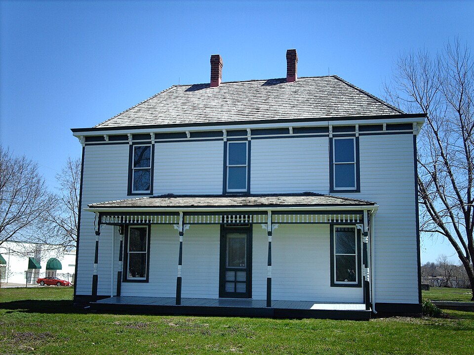
Photograph of Harry S. Truman Farm Home
Photograph by Nationalparks, CC BY-SA 2.5. Via Wikimedia Commons.

Young, Solomon, Farm-Truman, Harry S., Farm

A National Historic Landmark. Listed on the National Register of Historic Places in 1978.

From the record

“Truman Farm Home, also known as the Solomon Young Farm, is a historic farm property at 12301 Blue Ridge Blvd in Grandview, Missouri. The farm property, first developed in the 1860s, was the residence of future U.S. president Harry S.”

Wikipedia article Harry S. Truman Farm Home, CC BY-SA 4.0.

One of 414 National Register listings published here for Jackson County · listed in 1978 · category: District · a National Historic Landmark.

Sources: the Wikipedia article · the case file at the National Archives · the National Register database, National Park Service

The listing

  • Listed as. Young, Solomon, Farm--Truman, Harry S., Farm - the National Register files a house under its owner's surname.
  • Address. 12121 and 12301 Blue Ridge Extension, Grandview, 64030
  • When was it listed? May 1978
  • Category. district
  • Township. Washington township
  • National Register reference number. 78001650 - the number the National Park Service assigned this property when it was listed, and the key its nomination file is catalogued under at the National Archives.

What happened here

An account from the chapter on Washington township. The inset identifies its exact source book and publication year.

From The History of Jackson County, Missouri, Containing a History of the County, Its Cities, Towns, Etc., Biographical Sketches of Its Citizens, Jackson County in the Late War... History of Missouri, Map of Jackson County .., published 1881 - Washington Township

New Santa Fe

This little post village is situated on the west line of Missouri, about midway in Washington township. It now contains one store and post-office and a few dwelhng houses. Being on the State line between a free and a slave State, it has experienced some of the most remarkable events that have been known on a turbulent border: the Border Ruffian War of 1855-6, the awful commotions of the Civil War, and the bands of outlaws, murderers and robbers since the War of the Rebellion ceased have haunted this section to an unwonted degree.

Read the rest of this passage

The ground it stands on

4,827 words

This property stands in Washington Township. The History of Jackson County, Missouri, Containing a History of the County, Its Cities, Towns, Etc., Biographical Sketches of Its Citizens, Jackson County in the Late War... History of Missouri, Map of Jackson County .., published 1881 gives that township a chapter of its own.

The chapter covers washington township organized february g^ 18^6, the orders of court fixing the boundaries, first election held at the house of anson mccrackin, the lost townships, physical features, old settlers.

Machine-read from a century-old scan, so expect the errors a machine makes: misspelled names, dropped words, stray characters.

Read the whole chapter on Washington Township - 4,827 words on its settlement, mills, schools and churches.

Fires near this property

25 since 2006

Regional context, not property-specific evidence. The federal wildfire occurrence database lists 25 fires within 5 miles of Young, Solomon, Farm-Truman, Harry S., Farm between 2006 and 2018, burning about 36 acres in total. 1 started naturally. 2 were recorded as arson. Distance is straight-line from the map coordinates, so a fire counted here may appear on a neighbouring settlement's page as well.

Reported cause Fires
Missing data/not specified/undetermined16
Equipment and vehicle use3
Debris and open burning2
Arson/incendiarism2
Natural1
Misuse of fire by a minor1

The most recent of them, most recent first, with the day each was reported and the service that recorded it.

DateCause SizeReported by Name on the report
29 September 2007Arson/incendiarism1.0 acresMissouri State Fire Marshal's Officenot named
16 September 2007Missing data/not specified/undeterminedunder an acreMissouri State Fire Marshal's Officenot named
13 September 2007Missing data/not specified/undeterminedunder an acreMissouri State Fire Marshal's Officenot named
3 August 2007Missing data/not specified/undeterminedunder an acreMissouri State Fire Marshal's Officenot named
23 August 2007Missing data/not specified/undetermined1.0 acresMissouri State Fire Marshal's Officenot named
23 August 2007Missing data/not specified/undetermined10 acresMissouri State Fire Marshal's Officenot named
17 August 2007Missing data/not specified/undeterminedunder an acreMissouri State Fire Marshal's Officenot named

Every fire recorded in Jackson County

Mines and quarries near this property

10 of 12 shown

Regional context, not property-specific evidence. The federal mineral resources record lists 12 workings within 5 miles of Young, Solomon, Farm-Truman, Harry S., Farm: 10 past producers, 2 producers. 2 still produce. What was taken out: Stone, Crushed/Broken. Distance is straight-line from the map coordinates, so a quarry counted here may appear on a neighbouring settlement's page as well.

Where SiteCommodity StatusRecorded
Beyer Mine and MillStone, Crushed/BrokenProducer
Beyer QuarryStone, Crushed/BrokenProducer
UnknownStone, Crushed/BrokenPast Producer
Unknown-LsStone, Crushed/BrokenPast Producer

Every working recorded in Jackson County

Storms near this property

37 since 1995

Regional context, not property-specific evidence. The National Weather Service names Grandview, the town this property stands in, in 37 storm reports between 1995 and 2025: 17 thunderstorm wind, 16 hail, 3 flash flood, 1 heavy rain. The reports record 3 injuries. Each account below is quoted exactly as the forecast office filed it, from the NOAA Storm Events Database, and each date opens the federal record of that event.

WhenEvent Place namedHarm What the report says
August 1996Thunderstorm WindGrandview3 hurt, $150,000no account filed
December 2008Thunderstorm WindGrandview$5,000Power lines and trees were downed and a roof was damaged at an apartment complex.
June 1995HailGrandview$3,000Hail up to one inch in diameter was reported by a spotter at the intersection of Interstate 435 and U.S. Route 71. The hail broke out a window on the spotter's car.
April 2010Thunderstorm WindGrandview$2,000A telephone pole was snapped in two, at High Grove Road and Raytown Road in Blue Springs, near the entrance of O'Donnell Park.
May 2007Heavy RainGrandview$2,000Three inches of rain has been measured since this morning.
August 2010Thunderstorm WindGrandview$400Thunderstorm wind gusts were estimated up to 60 mmph, with road signs blown down.
March 2025Thunderstorm WindGrandview-Downed tree at a residence in Grandview.
April 2024Thunderstorm WindGrandview-Power lines downed just east of the state line west of Grandview.
July 2024Thunderstorm WindGrandview-Downed trees and wires in Grandview.
May 2024Thunderstorm WindGrandview-Shortly before 3 PM CST, public reported tree limbs down due to estimated 60 mph wind gusts from a severe thunderstorm moving through downtown Grandview, MO.
May 2024Thunderstorm WindGrandview-Three inch tree limbs broken; power poles broken near the Grandview Triangle.
September 2023HailGrandview-Social media report of quarter sized hail in Grandview.
July 2019Flash FloodGrandview-Several cars were stalled in and around the Grandview area due to rising flood water.
May 2018Thunderstorm WindGrandview-Signs were down and tree damage was reported at Harry S Truman Road.
March 2017Thunderstorm WindGrandview-A narrow swath of wind, perhaps consistent with a mesovortex did some damage to portions of Grandview. Power lines were reported down across the city and several structures had some minor roof and siding damage. Straight line thunderstorm wind was determined to the be the cause due to the unidirectional layout of the debris field.
July 2014Thunderstorm WindGrandview-A trained spotter reported a 60 mph wind gust near Grandview.
May 2013Thunderstorm WindGrandview-Thunderstorm wind gusts were estimated up to 60 mph.
June 2011Thunderstorm WindGrandview-Thunderstorm wind gusts were estimated up to 75 mph.
March 2007Flash FloodGrandview-Numerous locations along US HWY 71 between Blue Parkway and 150th Street impassable due to high water.
February 2007Flash FloodGrandview-Numerous locations along US HWY 71 between Blue Parkway and 150 Street impassable due to high water.
July 2000Thunderstorm WindGrandview-An off-duty NWS employee reported a tree 3 feet in diameter was downed.
May 2017HailGrandview-no account filed
October 2014HailGrandview-no account filed
April 2011HailGrandview-no account filed
May 2011HailGrandview-no account filed
May 2007HailGrandview-no account filed
March 2006Thunderstorm WindGrandview-no account filed
March 2006HailGrandview-no account filed
September 2004HailGrandview-no account filed
March 2003HailGrandview-no account filed
May 2003HailGrandview-no account filed
March 2000HailGrandview-no account filed
May 2000HailGrandview-no account filed
April 2000HailGrandview-no account filed
July 1996Thunderstorm WindGrandview-no account filed

Every storm recorded in Jackson County

Map coverage status

No historic map-sheet match is published for this property yet. That does not mean no map exists. This record needs a coordinate-quality review before it can be joined to a sheet boundary. Browse the county's mapped places while that work is pending.

Listed places nearby

6 within 8 miles

Other National Register properties close enough to walk or drive between, ordered by distance from this one. Both positions come from the same geocoding pass that matched these properties to their map sheets.

Sources for this property

National Archives recordThe nomination case file for reference 78001650 in Record Group 79.
Wikipedia articleCommunity-written account of this property, licensed CC BY-SA.
Jackson CountyAll 414 listed properties in this county.

Provenance

  • Listing record. National Park Service National Register of Historic Places, listed-properties dataset, current to 2026-05-22.
  • Map join. Address geocoded through the United States Census geocoder, then tested against the published boundary of every sheet in the USGS Historical Topographic Map Collection.
  • How this page is made. Listing fields come from federal records; map-sheet coverage is a labelled coordinate-to-boundary calculation, not a source-field claim.
  • Wildfire. Short, Karen C. 2022. Spatial wildfire occurrence data for the United States, 1992-2020 [FPA_FOD_20221014]. 6th Edition. Fort Collins, CO: Forest Service Research Data Archive. https://doi.org/10.2737/RDS-2013-0009.6 Collected with United States Government funding and usable without additional permissions or fees.
  • Mines and quarries. USGS Mineral Resources Data System (MRDS) https://mrdata.usgs.gov/mrds/ A work of the United States government, no copyright under 17 U.S.C. 105.
  • Storms. NOAA National Centers for Environmental Information, Storm Events Database https://www.ncei.noaa.gov/stormevents/ A work of the United States government, no copyright under 17 U.S.C. 105. Narratives are quoted verbatim from the National Weather Service report and are not edited or summarised.