BlockBefore
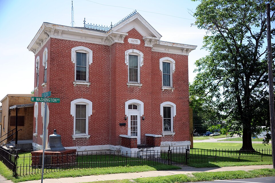
Photograph of Carroll County Sheriff's Quarters and Jail
Photograph by Keith Snyder, CC BY-SA 4.0. Via Wikimedia Commons.

Carroll County Sheriff's Quarters and Jail

Listed on the National Register of Historic Places in 1979.

From the record

“Carroll County Sheriff's Quarters and Jail is a historic combined sheriffs residence and jail located in Carrollton, Carroll County, Missouri. It was built in 1878 and consists of the two-story brick residence with an attached jail, constructed in 1958 to replace the original jail, which had collapsed.”

Wikipedia article Carroll County Sheriff's Quarters and Jail, CC BY-SA 4.0.

One of 5 National Register listings published here for Carroll County · listed in 1979 · category: Building.

Sources: the Wikipedia article · the case file at the National Archives · the National Register database, National Park Service · the Wikipedia article

The listing

  • What is counted as historic. The nomination lists 1 building as contributing to the listing.
  • Address. 101 W. Washington St., Carrollton, 64633
  • When was it listed? October 1979
  • Category. building
  • Township. Carrollton township
  • Architectural style. Neoclassical architecture
  • National Register reference number. 79001355 - the number the National Park Service assigned this property when it was listed, and the key its nomination file is catalogued under at the National Archives.

The ground it stands on

4,119 words

The chapter on Carrollton Township in History of Carroll County, Missouri : Carefully Written and Compiled from the Most Authentic Official and Private Sources, Including a History of Its Townships, Cities, Towns and Villages, Together with a Condensed History of Missouri ; the Constitution of the United States, and State of Missouri ; a Military Record of Its Volunteers in Either Army of the Great Civil War ; General and Local Statistics ; Miscellany ; Reminiscences, Grave, Tragic and Humorous ; Biographical Sketches of Prominent Men and Citizens Identified with the Interests of the Country, published 1881 names Carrollton. This is what it says, exactly as the scans read.

Carrollton, the county seat Carroll county, is located on the line of the Wabash, St. Louis & Pacific railroad, 209 miles north-west of St. Louis, .and 66 miles east of Kansas City. It is located on a high bluff* overlooking the Mirrouri river bottoms, and contains a population of nearly 4,000 souls. Statistics can'be produced showing that her annual trade is far ahead of any towns on the line of the railroad or river, and is constantly increasing. She can boast of more fine, large business houses than any town outside of the metropolis of the state, and probably St. Joseph and Kansas City. She has more large hearted, public spirited citizens, more energy, more git-up and go ahead than half a dozen ordinary county, towns.

Passage source: History of Carroll County, Missouri : Carefully Written and Compiled from the Most Authentic Official and Private Sources, Including a History of Its Townships, Cities, Towns and Villages, Together with a Condensed History of Missouri ; the Constitution of the United States, and State of Missouri ; a Military Record of Its Volunteers in Either Army of the Great Civil War ; General and Local Statistics ; Miscellany ; Reminiscences, Grave, Tragic and Humorous ; Biographical Sketches of Prominent Men and Citizens Identified with the Interests of the Country, published 1881.

The first improvements made in the present limits of the city, was by John Standley, the report of which is found in the history of Carrollton township. The next was by Morgan P. Ellis, on lot 5, block 9, corner of Main and Benton streets, and now occupied by the commodious storehouse of Baum & David. About this time John Trotter put up a log house near where the African M. E. church is located.

Passage source: History of Carroll County, Missouri : Carefully Written and Compiled from the Most Authentic Official and Private Sources, Including a History of Its Townships, Cities, Towns and Villages, Together with a Condensed History of Missouri ; the Constitution of the United States, and State of Missouri ; a Military Record of Its Volunteers in Either Army of the Great Civil War ; General and Local Statistics ; Miscellany ; Reminiscences, Grave, Tragic and Humorous ; Biographical Sketches of Prominent Men and Citizens Identified with the Interests of the Country, published 1881.

Machine-read from a century-old scan, so expect the errors a machine makes: misspelled names, dropped words, stray characters.

Read the whole chapter on Carrollton Township - 4,119 words on its settlement, mills, schools and churches.

Fires near this property

20 since 1992

Regional context, not property-specific evidence. The federal wildfire occurrence database lists 20 fires within 5 miles of Carroll County Sheriff's Quarters and Jail between 1992 and 2019, burning about 122 acres in total. None started naturally. None was recorded as arson. Distance is straight-line from the map coordinates, so a fire counted here may appear on a neighbouring settlement's page as well.

Reported cause Fires
Debris and open burning12
Missing data/not specified/undetermined7
Smoking1

The most recent of them, most recent first, with the day each was reported and the service that recorded it.

DateCause SizeReported by Name on the report
9 April 1992Debris and open burning1.0 acresMissouri Department of Conservationnot named
6 April 1992Debris and open burning4.0 acresMissouri Department of Conservationnot named
6 April 1992Debris and open burning1.0 acresMissouri Department of Conservationnot named
4 April 1994Debris and open burning2.0 acresMissouri Department of Conservationnot named
16 April 2019Missing data/not specified/undetermined5.2 acresMissouri Department of Conservation178604-01749-04162019-1533
16 April 2019Missing data/not specified/undetermined7.1 acresMissouri Department of Conservation178603-01749-04162019-1040
8 March 2018Missing data/not specified/undetermined3.8 acresMissouri Department of Conservation176253-01749-03082018-1223
8 March 1997Debris and open burning5.0 acresMissouri Department of Conservationnot named

Every fire recorded in Carroll County

Mines and quarries near this property

8 within 5 miles

Regional context, not property-specific evidence. The federal mineral resources record lists 8 workings within 5 miles of Carroll County Sheriff's Quarters and Jail: 8 past producers. None of them still produces. What was taken out: Stone, Crushed/Broken, Sand and Gravel, Construction. Distance is straight-line from the map coordinates, so a quarry counted here may appear on a neighbouring settlement's page as well.

Where SiteCommodity StatusRecorded
Unknown - S & GSand and Gravel, ConstructionPast Producer
Minnis + Trotten QuarryStone, Crushed/BrokenPast Producer
Unknown - LimestoneStone, Crushed/BrokenPast Producer
Unknown - LsStone, Crushed/BrokenPast Producer

Every working recorded in Carroll County

Storms near this property

60 of 71 shown

Regional context, not property-specific evidence. The National Weather Service names Carrollton, the town this property stands in, in 71 storm reports between 1995 and 2023: 37 hail, 28 thunderstorm wind, 4 flash flood, 2 tornado. No death or injury is recorded in these reports. Each account below is quoted exactly as the forecast office filed it, from the NOAA Storm Events Database, and each date opens the federal record of that event.

WhenEvent Place namedHarm What the report says
March 2002Thunderstorm WindCarrollton$25,000Roof blown off a house. Silo blown over onto church.
May 2000Thunderstorm WindCarrollton$10,000Thunderstorm winds damaged the roof of a home east of Carrollton.
August 2006Thunderstorm WindCarrollton$2,000Trees...large limbs...and a power pole down.
June 2004Thunderstorm WindCarrollton$2,000Power lines down.
April 2010Thunderstorm WindCarrollton$1,000A power pole was broken on Highway D near Highway E.
March 2006Thunderstorm WindCarrollton$1,000Roof damage to building on Highway 65.
July 2006Thunderstorm WindCarrollton$1,000Several trees and power lines downed.
August 2023Thunderstorm WindCarrollton-Power line downed in Carrollton and power is out.
August 2016Flash FloodCarrollton-Flash flooding washed out a basement, causing a house to come off the foundation. Cost of this damage is unknown.
July 2016Thunderstorm WindCarrollton-Several large trees of unknown size or condition were down in Carrolton.
April 2014Thunderstorm WindCarrollton-Trees blown onto power lines and buildings damage in town.
June 2010Thunderstorm WindCarrollton-Thunderstorm winds were estimated up to 60 mph.
June 2010Flash FloodCarrollton-Water was reported over Highway UU, near Big Creek.
June 2009Thunderstorm WindCarrollton-Thunderstorm wind gusts to 60 mph were estimated.
July 2008Flash FloodCarrollton-Route E was closed due to high water.
August 2007Tornado (EF0)Carrollton-Delayed report received from public via broadcast media. Brief tornado touchdown at 1405 CST. No damage noted.
August 2006Thunderstorm WindCarrollton-Trees and limbs down in town.
July 2005Thunderstorm WindCarrollton-6 to 8 inch tree limbs blown down.
March 2000Thunderstorm WindCarrollton-The sheriff's department reported 60 mph winds in Carrollton.
April 2000HailCarrollton-Quarter size hail covered the ground west of Carrollton.
June 2000Tornado (F0)Carrollton-Two citizens reported that a tornado touched down briefly in open bottomland, and moved east 1 mile. The tornado lifted after approximately two minutes on the ground, without doing any damage.
September 2000Thunderstorm WindCarrollton-The Carrollton Fire Department recorded at 61 mph wind gust.
August 2000Thunderstorm WindCarrollton-Tree limbs up to 6 inches in diameter were downed.
February 1999Thunderstorm WindCarrollton-62 MPH wind gust reported at Carrollton.
August 1998Thunderstorm WindCarrollton-The Carrollton Fire Department reported a 60 MPH wind gust during a thunderstorm at Carrollton.
June 1998HailCarrollton-Quarter-size hail was reported by a spotter 10 miles west of Carrollton.
July 1995HailCarrollton-A severe thunderstorm produced quarter-size hail in Carrollton. Very heavy rain also fell with the storm as 1.3 inches were measured in 15 minutes at Carrollton.
September 1995Thunderstorm WindCarrollton-A severe thunderstorm knocked numerous trees down in Carrollton.
June 1995Thunderstorm WindCarrollton-The sheriff's office at Carrollton reported a wind gust to 65 mph.
April 2019HailCarrollton-no account filed
May 2019HailCarrollton-no account filed
April 2014HailCarrollton-no account filed
June 2011HailCarrollton-no account filed
May 2010HailCarrollton-no account filed
April 2010HailCarrollton-no account filed
May 2009HailCarrollton-no account filed
June 2008HailCarrollton-no account filed
June 2008Thunderstorm WindCarrollton-no account filed
June 2008HailCarrollton-no account filed
July 2008HailCarrollton-no account filed
June 2008Thunderstorm WindCarrollton-no account filed
June 2007HailCarrollton-no account filed
October 2007HailCarrollton-no account filed
April 2006HailCarrollton-no account filed
March 2006HailCarrollton-no account filed
May 2005HailCarrollton-no account filed
March 2003HailCarrollton-no account filed
March 2002Thunderstorm WindCarrollton-no account filed
May 2002HailCarrollton-no account filed
May 2002Thunderstorm WindCarrollton-no account filed
May 2002HailCarrollton-no account filed
June 2002Thunderstorm WindCarrollton-no account filed

Every storm recorded in Carroll County

Map coverage status

No historic map-sheet match is published for this property yet. That does not mean no map exists. This record needs a coordinate-quality review before it can be joined to a sheet boundary. Browse the county's mapped places while that work is pending.

Listed places nearby

3 within 8 miles

Other National Register properties close enough to walk or drive between, ordered by distance from this one. Both positions come from the same geocoding pass that matched these properties to their map sheets.

Photograph PropertyDistance Listed
Wilcoxson and Company Bankunder 500 feet1983
Carroll County Court Houseunder 500 feet1995
U.S. Post Office0.3 miles1977

Sources for this property

National Archives recordThe nomination case file for reference 79001355 in Record Group 79.
Wikipedia articleCommunity-written account of this property, licensed CC BY-SA.
Carroll CountyAll 5 listed properties in this county.

Provenance

  • Listing record. National Park Service National Register of Historic Places, listed-properties dataset, current to 2026-05-22.
  • Map join. Address geocoded through the United States Census geocoder, then tested against the published boundary of every sheet in the USGS Historical Topographic Map Collection.
  • How this page is made. Listing fields come from federal records; map-sheet coverage is a labelled coordinate-to-boundary calculation, not a source-field claim.
  • Wildfire. Short, Karen C. 2022. Spatial wildfire occurrence data for the United States, 1992-2020 [FPA_FOD_20221014]. 6th Edition. Fort Collins, CO: Forest Service Research Data Archive. https://doi.org/10.2737/RDS-2013-0009.6 Collected with United States Government funding and usable without additional permissions or fees.
  • Mines and quarries. USGS Mineral Resources Data System (MRDS) https://mrdata.usgs.gov/mrds/ A work of the United States government, no copyright under 17 U.S.C. 105.
  • Storms. NOAA National Centers for Environmental Information, Storm Events Database https://www.ncei.noaa.gov/stormevents/ A work of the United States government, no copyright under 17 U.S.C. 105. Narratives are quoted verbatim from the National Weather Service report and are not edited or summarised.