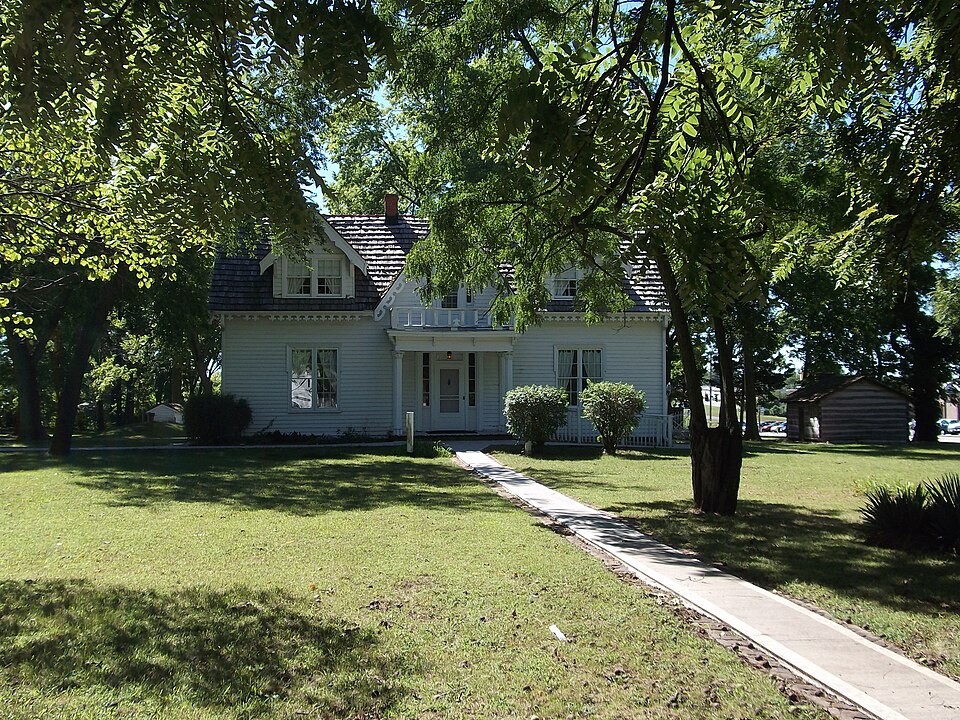
National Register reference number.79001376- the number the National Park Service assigned this property when it was listed, and the key its nomination file is catalogued under at the National Archives.
For many years education and schools did not receive that attention which their importance demands. The age in which we now live, tells to each reflecting mind, these are a part 0/ the body poliiic. But pioneer life had its charms, in roving among the wilds of nature. Education and schools did not occupy enough of their thoughts. It required an effort to build the first school house. This rude structure was about three hundred yards south of the present residence of Mr. T. W. Green. The people then called it "Science Hill." But one and another taught several good "subscription schools" there - averaging from fifty to sixty scholars. Now, within four miles .of the spot where stood "Science Hill school house," are eight or nine well organized school districts - each having a good school house ; and furnished with the latest and best patented seats, etc. Few if any of them have less than seven or eight months' school in each year. Self interest, if nothing else, will compel them in the near future to build a high school at Raytown, and perhaps also at other places. When this shall be accomplished Brooking township will be one of the most inviting localites for a country residence to be found any where in the great State of Missouri.
Brooking township has ever been the home of good, skillful physicians. Dr. Samuel Hobbs, deceased, was one of the most successful practitioners the county ever had. Dr. R. Hewitt, was also a good physician, and resided for many years in Raytown. Dr. M. T. Smith now has an extensive practice, and is a skillful physician.
Regional context, not property-specific
evidence. The
federal wildfire occurrence database
lists 40 fires within 5 miles of Rice-Tremonti House
between 2007 and 2008, burning about 124 acres in total. 1 started naturally. 3 were recorded as arson.
Distance is straight-line from the map coordinates, so a fire counted
here may appear on a neighbouring settlement's page as well.
Reported cause
Fires
Missing data/not specified/undetermined
27
Recreation and ceremony
5
Debris and open burning
4
Arson/incendiarism
3
Natural
1
The most recent of
them, most recent first, with the day each was reported and the service
that recorded it.
Regional context, not property-specific
evidence. The federal mineral resources record lists
34 workings within 5 miles of Rice-Tremonti House: 30 past producers, 4 producers.
4 still produce. What was taken out: Stone, Crushed/Broken, Clay. Distance is straight-line from the
map coordinates, so a quarry counted here may appear on a neighbouring
settlement's page as well.
Regional context, not property-specific
evidence. The National Weather Service names
Raytown, the town this property stands in, in 42 storm reports between 1993 and 2025: 19 hail, 17 thunderstorm wind, 3 flash flood, 1 flood.
No death or injury is recorded in these reports. Each account below is quoted exactly as the forecast office
filed it, from the NOAA Storm Events Database, and each date
opens the federal record of that event.
Large hail fell at various locations in the eastern Kansas City suburbs, including along Interstate 435, Highway 350, and near Blue Ridge Mall. Numerous car dealerships along Noland Road in Independence reported substantial damage to automobiles. Many city owned vehicles had damage, including broken windows and dents.
A line of severe thunderstorms produced several tornadoes, one of which impacted neighborhoods of Raytown. The extent of the damage was to large trees, some of which fell onto houses, causing some roof and structural damage.
An elm tree limb approximately 12 to 14 feet long came down on a home. The condition of the limb is unknown and the extent of the damage to the home is also unknown. This report was received via social media.
No historic map-sheet match is published
for this property yet. That does not mean no map exists. This record needs
a coordinate-quality review before it can be joined to a sheet boundary.
Browse the county's mapped places while that work is
pending.
Listed places nearby
6 within 8 miles
Other National Register properties close
enough to walk or drive between, ordered by distance from this one. Both
positions come from the same geocoding pass that matched these properties
to their map sheets.
Listing record. National Park Service National Register of Historic Places, listed-properties dataset, current to 2026-05-22.
Map join. Address geocoded through the United States Census geocoder, then tested against the published boundary of every sheet in the USGS Historical Topographic Map Collection.
How this page is made. Listing fields come from federal records; map-sheet coverage is a labelled coordinate-to-boundary calculation, not a source-field claim.
Wildfire. Short, Karen C. 2022. Spatial wildfire occurrence data for the United States, 1992-2020 [FPA_FOD_20221014]. 6th Edition. Fort Collins, CO: Forest Service Research Data Archive. https://doi.org/10.2737/RDS-2013-0009.6 Collected with United States Government funding and usable without additional permissions or fees.
Mines and quarries. USGS Mineral Resources Data System (MRDS) https://mrdata.usgs.gov/mrds/ A work of the United States government, no copyright under 17 U.S.C. 105.
Storms. NOAA National Centers for Environmental Information, Storm Events Database https://www.ncei.noaa.gov/stormevents/ A work of the United States government, no copyright under 17 U.S.C. 105. Narratives are quoted verbatim from the National Weather Service report and are not edited or summarised.
 Block