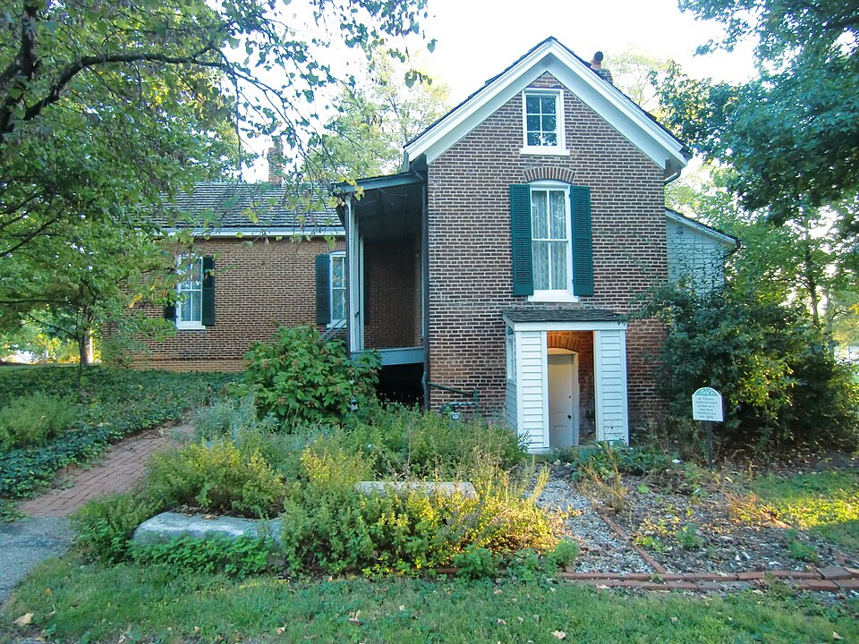
Built in 1870. Listed on the National Register of Historic Places in 1979.
From the record
“Payne-Gentry House is a historic one story, red brick, vernacular-style cottage home located in Bridgeton, St. The Payne-Gentry house contains the only surviving historic Missouri house with a restored doctor's office from the 19th century period.”
Wikipedia article Payne-Gentry House, CC BY-SA 4.0.
One of 663 National Register listings published here for St. Louis County · listed in 1979 · category: Building · built in 1870.
National Register reference number.79003202- the number the National Park Service assigned this property when it was listed, and the key its nomination file is catalogued under at the National Archives.
Fires near this property
1 since 2014
Regional context, not property-specific
evidence. The
federal wildfire occurrence database
lists 1 fire within 5 miles of Payne-Gentry House
in 2014, burning about 1 acre in total. None started naturally. None was recorded as arson.
Distance is straight-line from the map coordinates, so a fire counted
here may appear on a neighbouring settlement's page as well.
Reported cause
Fires
Missing data/not specified/undetermined
1
The most recent of
them, most recent first, with the day each was reported and the service
that recorded it.
Regional context, not property-specific
evidence. The federal mineral resources record lists
5 workings within 5 miles of Payne-Gentry House: 4 past producers, 1 producer.
1 still produces. What was taken out: Stone, Crushed/Broken, Clay. Distance is straight-line from the
map coordinates, so a quarry counted here may appear on a neighbouring
settlement's page as well.
Regional context, not property-specific
evidence. The National Weather Service names
Bridgeton, the town this property stands in, in 28 storm reports between 1993 and 2025: 18 hail, 7 thunderstorm wind, 2 tornado, 1 flash flood.
The reports record 2 injuries. Each account below is quoted exactly as the forecast office
filed it, from the NOAA Storm Events Database, and each date
opens the federal record of that event.
The tornado began in Bridgeton on Pennridge Drive, just northeast of St. Charles Rock Road. A skating rink in this location suffered EF-1 roof damage. The tornado moved northeast causing sporadic EF-0 and EF-1 tree damage for about 3 miles crossing Highway 370 in the process. The tornado intensified to EF-2 strength in Hazelwood near Woodcrest Lane where the roof was torn off a home. The tornado was also at its maximum width at this location reaching 500 yards wide. Along Teson Road, north of Howdershell Road, 10 apartment buildings were damaged with 5 buildings losing portions of their roofs. The tornado then turned a bit to the east and caused EF-2 damage at Lynn Haven Lane and Howdershell Road. Two homes at this location lost most of their roofs. Also, across the street on the north side of Howdershell Road a strip mall had small portions of the roof removed, as well as glass windows and doors shattered. Tree damage, EF-0 to EF-1 strength, occurred along Lamplight Lane, Coach Light Lane, Caposele Lane, and Gerardini Drive. Several homes on these streets suffered roof damage from falling trees and large tree limbs. The area from Lynn Haven Lane to Gerardini Drive had the highest concentration of damage. As the tornado moved east northeast into Florissant sporadic EF-0 to EF-1 tree damage occurred to just east of St. Ferdinand Park along Beverly Drive. Also, just south of St. Ferdinand Park, another strip mall at the intersection of Lindbergh Boulevard and St. Jean Street sustained minor roof damage. The tornado moved very fast, covering 6.75 miles in about 5 minutes. Sporadic thunderstorm wind gust damage, mainly tress uprooted or large limbs downed, was noted north and south of the tornado track. Several business signs were also damaged along Lindbergh Blvd. in Florissant. Two people sustained minor injuries. One had a broken leg and another just had some scrapes and bruises. Almost 400 structures sustained some kind of damage. Fifty five of these structures were either destroyed or sustained significant damage. The tornado was rated EF-2 overall. The maximum path width was 500 yards and the path length was 6.75 miles.
Downburst winds damaged numerous roofs and toppled large trees in suburbs surrounding Lambert Field. Damage was very localized and accompanied by very heavy rain.
Storm spotters reported hail up to 1.25 inch in diameter near Creve Coeur Lake at 2128 CST. A roof was damaged on a restaurant on north Highway 67 in Florissant shortly after that. Emergency Management officials reported 1.00-inch-diameter hail up a foot deep along buildings in Bridgeton.
The tornado touched down approximately 50 yards north of the intersection of Earth City Express Way and St. Charles Rock Road. A stop sign and minor tree damage occurred at this location. Video from a storm chaser showed the tornado then travelled over Interstate 370 east of the Earth City Express Way/I-370 interchange, lofting debris. The tornado was also observed and videotaped while passing west and northwest of the Mills Outlet Mall. Tree branch damage was found on Garner Lane northwest of the mall and near the intersection of Teson Road and Aubuchon Road. The tornado paralleled Aubuchon Road and then hit two machine sheds. About 90 percent of the panels from one machine shed were removed while 40 percent of the panels were removed from the second machine shed. The tornadic damage was 40 yards wide at this location. The tornado continued to move northeast and travelled over Charbonier Road and caused more minor tree damage just north of the road. The tornado then lifted and dissipated. Overall, the tornado was rated EF0. It was on the ground for 4.22 miles with a max path width of 40 yards.
Up to three inches of rain fell in a short amount of time causing flash flooding. Several roads were flooded including Aubuchon Road and Teson Road in north county and Theiss Road in south county.
No historic map-sheet match is published
for this property yet. That does not mean no map exists. This record needs
a coordinate-quality review before it can be joined to a sheet boundary.
Browse the county's mapped places while that work is
pending.
Listed places nearby
6 within 8 miles
Other National Register properties close
enough to walk or drive between, ordered by distance from this one. Both
positions come from the same geocoding pass that matched these properties
to their map sheets.
Listing record. National Park Service National Register of Historic Places, listed-properties dataset, current to 2026-05-22.
Map join. Address geocoded through the United States Census geocoder, then tested against the published boundary of every sheet in the USGS Historical Topographic Map Collection.
How this page is made. Listing fields come from federal records; map-sheet coverage is a labelled coordinate-to-boundary calculation, not a source-field claim.
Wildfire. Short, Karen C. 2022. Spatial wildfire occurrence data for the United States, 1992-2020 [FPA_FOD_20221014]. 6th Edition. Fort Collins, CO: Forest Service Research Data Archive. https://doi.org/10.2737/RDS-2013-0009.6 Collected with United States Government funding and usable without additional permissions or fees.
Mines and quarries. USGS Mineral Resources Data System (MRDS) https://mrdata.usgs.gov/mrds/ A work of the United States government, no copyright under 17 U.S.C. 105.
Storms. NOAA National Centers for Environmental Information, Storm Events Database https://www.ncei.noaa.gov/stormevents/ A work of the United States government, no copyright under 17 U.S.C. 105. Narratives are quoted verbatim from the National Weather Service report and are not edited or summarised.
 Block